General Information
Nahiya (Subdistrict)
Mabeta
Also Known As
Amaro, Anbar, Anbarli, Emara, أنبار, انبارلي, عماورو
Tribes
Badîna
Families, Clans, etc.
Bîro, Ehmed Rûto, Gilkawî, Mehemedê Elî, Mûsa, Nivîsê, Osman Axa Şorbe

Photos
Basic Information about Emara
Source: Afrin Flo
Etymology: Named after the original founder or owner, possibly related to the 'Elewa ancestors
Springs: Delîb
Wells: Bîra Deferê
Other Landmarks: Sarînc
Summaries
I. Summary from TirejAfrin Site (English) of Emara
Source: https://www.tirejafrin.com/site/kura%20afrin%20%20%20mebetli%20-%20emara.htm
It is stated in the book جبل الكرد (عفرين) دراسة جغرافية Çiyayê Kurmênc (Efrîn): A Geographical Study by د. محمد عبدو علي Dr. Mihemed Ebdo Elî:
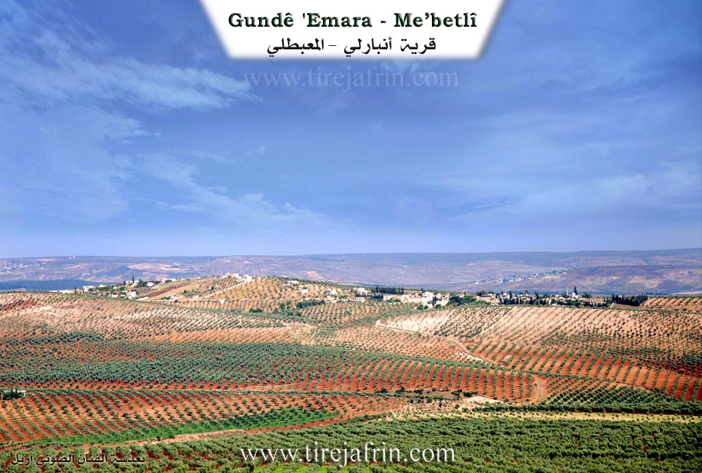
Emara, Anbarlî, Anbar, /654 inhabitants - 340 hectares - 8km - 430m/:
The name is pronounced "Emara". As for "Ambarlû", it is a Kurdish tribe found around the city of Bedlîs and the regions of Dêrsim, Mûş, and Amed /B. Lerch, p.49/. It is a medium-sized village located on a high limestone slope, surrounded by wide fields of olives.
It is stated in the book عفرين .... نهرها وروابيها الخضراء Efrîn... Her River and Her Green Hills by the writer عبدالرحمن محمد Ebdulrehman Mihemed from the village of Qetme:
Anbarlî: A village in Çiyayê Kurmênc, belonging to the Mabeta district, Efrîn region, Heleb governorate. It is a small village located in the central part of Çiyayê Kurmênc on the slope of a high limestone rocky elevation. It is furrowed by small torrents descending southward towards agricultural lands with clay soil. It is located 10km towards the northeast from the district center.
It is bordered to the north by a slope and a fertile plain planted with olive trees, the high mountain heights of Çiyayê Hawarê, and the villages of Daxoba and Rûta. It is bordered to the south by a slope, a wide and agriculturally fertile plain, Newala Zerafke (Zerafke valley), and the villages of Eyn Hecerê Mezin and Biçûk. It is bordered to the west by a slope, a plain, Kaniya Zerafke (Zerafke spring), and the villages of Ebrez and Şêx Kêlo. To the east is the village of Şêx Hotko at a distance of 700m.
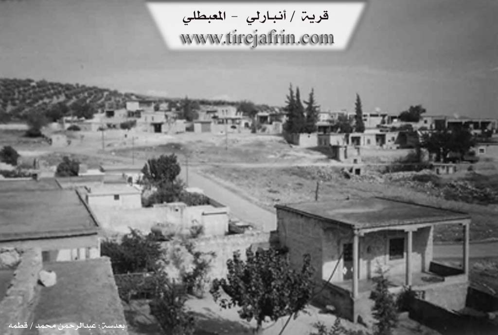
The number of its houses is about 55, and its age is about 350 years. Its old residences are made of stone and mud with flat wooden roofs, while the modern ones are concrete, spreading towards the east and west and around the public road. An electricity network and a primary school are available, as well as a small mosque in the center of the village.
The village drinks from cisterns that collect rainwater in winter, and currently from artesian wells dug next to the houses. It is connected to the district center by a paved road that passes through its center to several neighboring villages.
The residents work in rain-fed agriculture on an area of 340 hectares (grains, olives, and melons), and irrigated agriculture from the waters of Zerafke, a tributary of the Efrîn river (pomegranates, cotton, summer vegetables, sugar beet), alongside raising sheep and goats. A modern olive press is available there. It is a beautiful village in terms of construction and its excellent location overlooking Deşta Kitix (Kitix plains).
Among its most important families are: the family of Ehmed Rûto and Osman Axa Şorbe (brother of Eslan Axa, and their origin is from the village of Şorbe).
Village Mukhtar: Sebrî Emîn Arslan
Preparation and execution:
Director of the Tirej Efrîn site: Ebdulrehman Hacî Osman
20/12/2013
II. Summary of Emara from Afrin Flo
Source: https://www.youtube.com/watch?v=5et9bqWmbyI
The village of 'Emara, located in the Efrîn region, is described by its residents as an ancient settlement with roots tracing back to the Roman era. According to local oral history shared by an elder named 'Ezîz, the village derives its name from its original founder or owner; he mentions that the 'Elewa people were the first to settle there and the name reflects this lineage. The historical depth of the village is anchored by its most prominent landmark, Bîra Deferê. This well is attributed to the Rûma (Romans) and is celebrated for its reliable water source which has never dried up.
Historically, the social and daily life of 'Emara revolved around Bîra Deferê. Before the advent of modern plumbing, the entire community, along with neighboring areas like Ma'melo, utilized this well for washing clothes, cleaning wool, and watering livestock. In the past, the village architecture consisted largely of earthen houses (xaniyê axê), and the community relied on four communal cisterns, referred to as sarînc, for water storage. There is also a water source known as Delîb, estimated to be between 30 and 45 years old, which served the village before modern infrastructure was established.
The social structure of 'Emara includes several distinct lineages. One shopkeeper identifies himself as Şiyar Mecîd Gilkawî, indicating the presence of the Gilkawî family. Other residents mention connections to specific patriarchs such as Nivîsê, Bîro, and Mûsa. The village also hosts residents with origins from outside the immediate vicinity; an elder named Mes'ûd notes that he originates from Badîna, though he has lived in 'Emara for a long time.
Economically, the village has transitioned from a purely agrarian lifestyle to one integrated with the urban economy of Efrîn. While elders recall a past defined by herding sheep, tending vineyards, and plowing with draft animals, the younger generation largely works in textile workshops (werşeyê xiyata) or commutes to the city for labor. Despite these changes, the residents maintain a reputation for being "kîbar" (gentle or decent) and hospitable, preserving the communal spirit of their village.
Transcriptions and Subtitles
| Source | Video | Subtitles | Transcript |
|---|---|---|---|
| Afrin Flo 1 | Watch Video | Download SRT | View Transcript |
Foundation/Origin Information of Emara
No specific origin story, but mentions important families: Ahmad Ruto family and Othman Agha Shorba (originally from Shorba Oghli village).
Source: TirejAfrin Site
Founded by the Amaro family. The original settlement ("Gundê kevin") was located higher up on the mountain.
Source: Afrin Flo Transcript
Possible Village Name Meaning of Emara
The name "Amara" or "Ambarlo" refers to a Kurdish tribe found around Badlis city and other regions.
Source: TirejAfrin Site