General Information
Nahiya (Subdistrict)
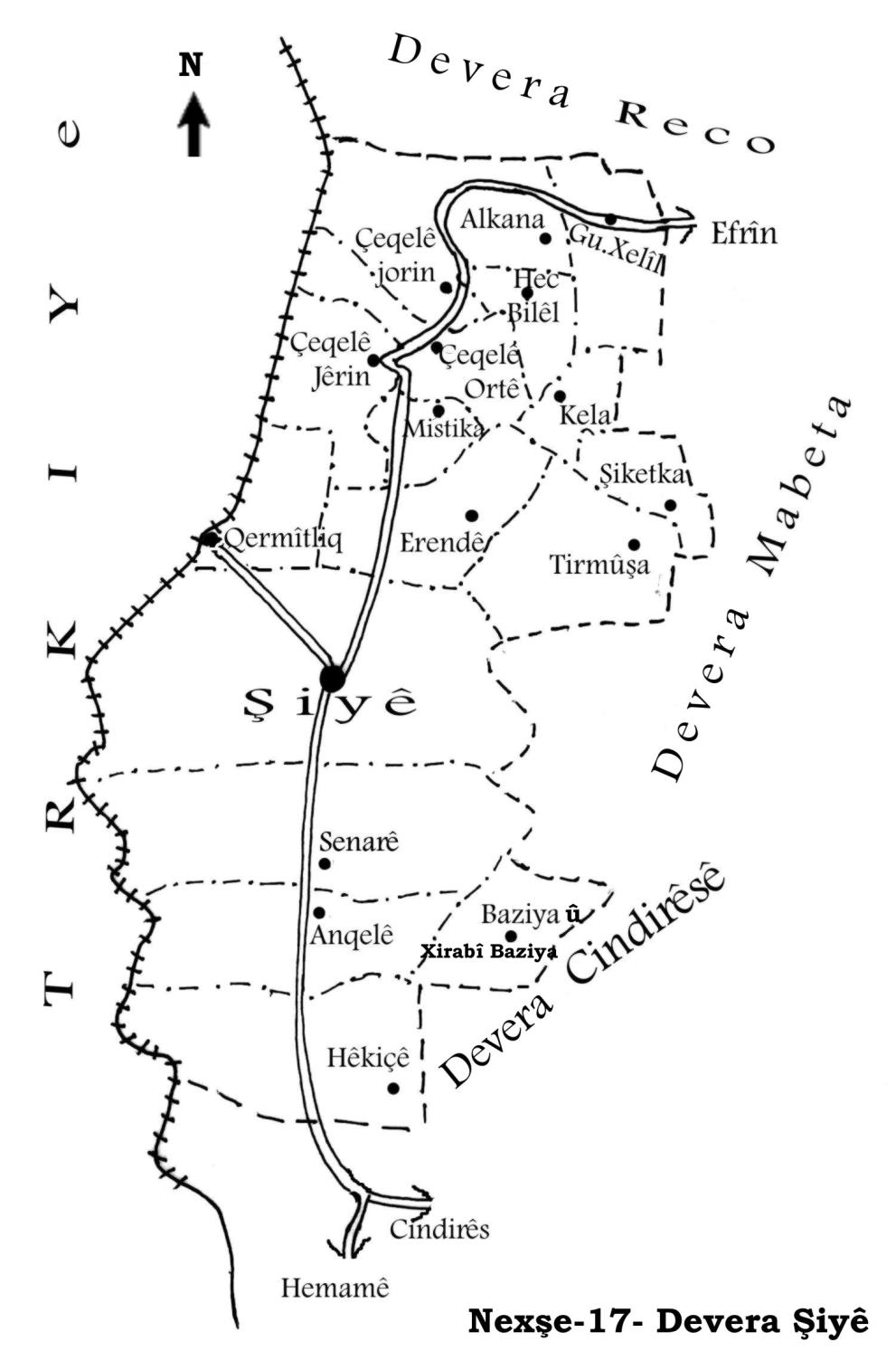
Şiyê
Also Known As
Al-Mazina, Arandê, Arenda, Erendê, أرندة, ارنده, المزينة
Tribes
Qazoxlî
Families, Clans, etc.
Behrî Henan, Ehmed Erendê, Evdikê, Hemoş, Heyder Yûsif, Zeqle, Çolaq
Photos
Basic Information about Erendê
Source: Afrin Flo
Etymology: Speakers suggest the name derives from Arande or Erendîn, interpreted locally as A-rind-ê, meaning "the beautiful one" or "it is beautiful"
Springs: Cewê Arende
Wells: Bîra Obzê
Other Landmarks: Gelî
Summaries
I. Summary from TirejAfrin Site (English) of Erendê
Source: https://www.tirejafrin.com/site/kura%20afrin%20%20%20shiye%20-%20arende.htm
According to the book Çiyayê Kurmênc (Efrîn): A Geographical Study by Dr. Mihemed Ebdo Elî: Erend, Erende, El Muzeyne / 2483 inhabitants, 505 hectares, 6km, 500m /:
We do not know a clear meaning for its name. As for the Arabized name "El Muzeyne", the translator believed that the Kurdish name is from "beauty", so he Arabized it to El Muzeyne.
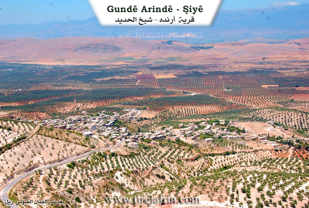
It is a medium sized village located on the southern side of the valley of Şiyê at the western slope of the height of Sifrê Dada mountain.
According to the book Efrîn... Her River and Her Green Hills by the writer Ebdulrehman Mihemed from the village of Qetme: Erend is a village in Çiyayê Kurmênc, following the district of Şêx El Hedîd, Efrîn area, Heleb governorate.
It is a large village located in the western section of the mentioned mountain, at the western slope of a limestone height called Çiyayê Welî Sifrê Dada and at the beginning of a water stream descending westwards where the flat agricultural lands extend, covered by alluvial soil. It is 6km away from the town of Şêx El Hedîd towards the northeast.
It is bordered to the north by a deep stream and the village of Mistikanlî, to the south by a plain planted with olive trees and the town of Şêx El Hedîd, to the west by a wide plain planted with olive trees and the village of Qeramitliq, and to the east by a high and rugged mountain chain planted with forestry trees and the village of Turmişkanlî.
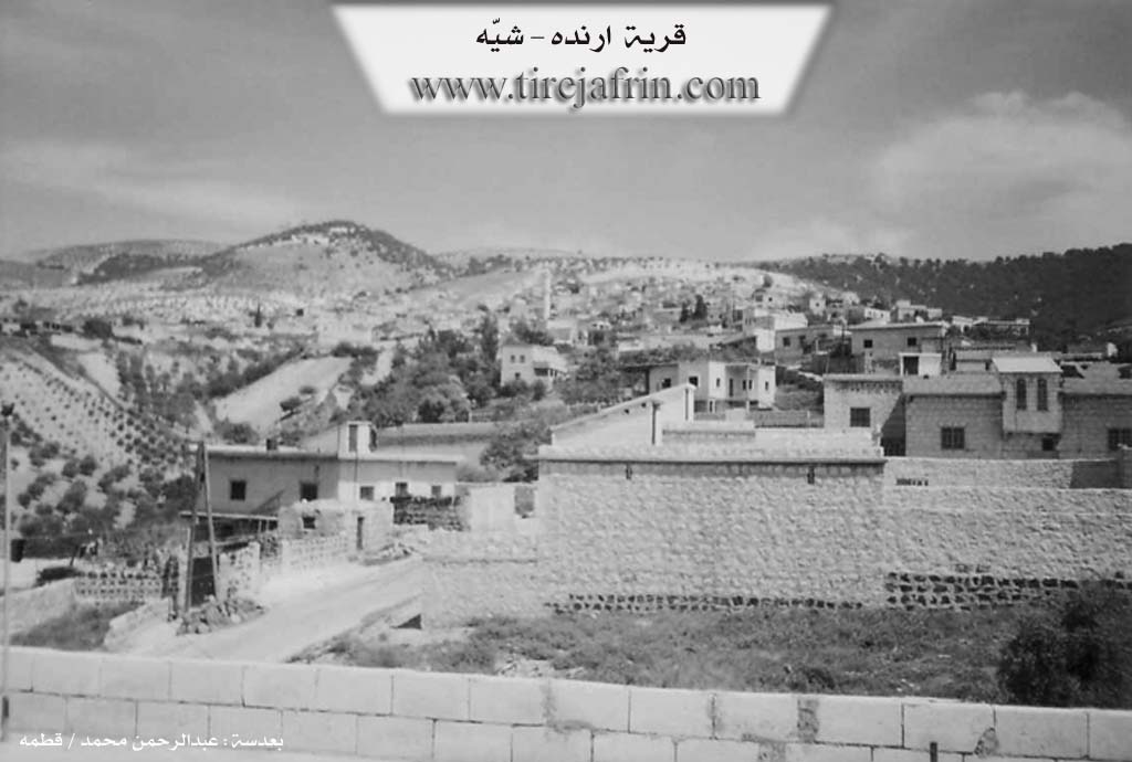
The number of its houses reaches about 150 houses and its age is about 400 years according to the account of residents. Its old dwellings are mud and stone with flat wooden roofs, and the modern ones are cement and stone extending north and west adjacent to the transportation roads with the neighboring villages.
Available in it are an electricity network, telephone, a primary school, another preparatory school, and a mosque in the center of the village. The residents drink from rainwater which is collected in cisterns dug next to the houses, and recently from a water network connected to the irrigation network of the villages of the Şêx El Hedîd center.
The residents work in rain fed agriculture (olives, grains, legumes, vines) on an area reaching 505 hectares. Olive trees constitute 90% of the agriculture alongside the raising of sheep and goats. It is connected to the center of the district by a winding asphalt road and it belongs to the municipality of Şêx El Hedîd. The farm of Kîlanlî follows it.
Mukhtar of the village: Xalid Hebeş
Sources:
- Book: جبل الكرد (عفرين) دراسة جغرافية Çiyayê Kurmênc (Efrîn): A Geographical Study by د. محمد عبدو علي Dr. Mihemed Ebdo Elî.
- Book: عفرين .... نهرها وروابيها الخضراء Efrîn... Her River and Her Green Hills by عبدالرحمن محمد Ebdulrehman Mihemed from the village of Qetme.
Preparation and execution:
- Manager of Tirej Efrîn site: Ebdulrehman Hacî Osman
- 20/12/2013
II. Summary of Erendê from Afrin Flo
Source: https://www.youtube.com/watch?v=y3H6WV9GodA
The village of Erendê, occasionally referred to as Arande or Aranda, is situated in the Efrîn region of northwestern Syria. Historically connected to the administrative district of Reco, the village is now administratively linked to the sub-district of Şiyê. According to local elders, the name Erendê is believed to be rooted in the Kurdish phrase A-rind-ê, signifying "the beautiful one" or relating to the concept of beauty (rind). While there were attempts by authorities to change the name to Mizrê, the residents continue to use the original Kurdish designation.
The social structure of Erendê is comprised of approximately 300 to 350 households, though a significant portion of the population has emigrated to Aleppo, Turkey, and Europe due to regional instability. Prominent local figures featured in the documentary include Ehmed Erendê (known as Ebu Mihemed), Qazoxlî Behrî Henan, Reşîd Heyder Yûsif, and Mhemedê Hemoş. The speaker Qazoxlî identifies his lineage as part of the Qazoxlî tribe or clan. The village is also home to the Evdikê family, specifically the house of Reşîdê Evdikê, and the Zeqle family, known for their well-tended gardens.
Life in Erendê has undergone a significant transition from traditional subsistence to modern challenges. In the past, the economy relied heavily on plowing (jût) with oxen and processing wheat into bulgur, a communal activity described vividly by an elderly female resident. Water scarcity was a defining hardship of the older era; women were forced to trek long distances to Şiyê or the Bîra Obzê (the Well of Obzê) to fetch water in tins or to wash clothes in the Gelî (valley).
Today, the village agriculture has shifted toward olive cultivation, sumac (simaq) harvesting, and personal gardens filled with figs (encûr), lemons (lêmûn), and maize (garisê Misirê), such as the one maintained by Zeqle. However, the community faces severe infrastructural difficulties, including a lack of electricity, forcing residents to rely on solar panels, and persistent water shortages that require purchasing water by the truckload. Bread is no longer baked locally in traditional ovens but is imported from Şiyê.
Culturally, the village retains a deep connection to Kurdish oral traditions. The documentary highlights the legacy of Mistefa Çolaq, a singer from the past remembered by the locals. Contemporary residents express a strong sense of nostalgia, contrasting the physical hardships of the past with the social fragmentation of the present, noting that while technology has made labor easier, the communal bonds and "taste" of life have diminished. The lyrics of songs performed in the village reference regional locations like Gundê Hulincê, Cindirêsê, and Deşta Qermetiqê, anchoring Erendê within the broader cultural geography of Efrîn.
Transcriptions and Subtitles
| Source | Video | Subtitles | Transcript |
|---|---|---|---|
| Afrin Flo 1 | Watch Video | Download SRT | View Transcript |
Foundation/Origin Information of Erendê
Established by the Jumblat family, who migrated from the mountains.
Source: Afrin Flo Transcript
Possible Village Name Meaning of Erendê
The meaning is unclear. The Arabized name "Al-Mazina" may come from a belief that the Kurdish name relates to "beauty."
Source: TirejAfrin Site
Two possible origins: 1) From Kurdish for "the place of the mill," referencing its historical water mills. 2) From the Arabic word "rende," meaning "beauty."
Source: Afrin Flo Transcript