General Information
Nahiya (Subdistrict)
Efrîn
Also Known As
Fafertinê, Fafirtin, Fafirtîn, Fafîn, Fefertînê, Kevnarê, فافرتين, فوفرتينة
Families, Clans, etc.
Mala Qesim, Mala Êlalka, Mala Şêxê, Malê Hano

Photos
Basic Information about Fafirtîn
Source: Ax û Welat
Etymology: Derived from 'ba firtone' (storm wind) due to the strong winds prevalent in the area
Foundation Date/Period: 2nd or 3rd century AD
Caves: Şikefta Rûş
Number of Caves: 360
Ruins: Kinîse, Keleha Xerab, Batût, Banasor, Sûrk, Bazêr
Other Landmarks: Kela Semanê, Basûfan, Bircê, Silêman, Şêx Aqîl, Qubtan el Cebel, Daraze
Summaries
I. Summary from TirejAfrin Site (English) of Fafirtîn
Source: https://www.tirejafrin.com/site/kura%20afrin%20markaz-fafrtin.htm
The following details appeared in the book جبل الكرد (عفرين) دراسة جغرافية Çiyayê Kurmênc (Efrîn): A Geographical Study by د. محمد عبدو علي Dr. Mihemed Ebdo Elî:
Fafertîn / 735 inhabitants, 35 km, 550 m /:
Ebdullah Hecar believes it is a Syriac name meaning "village of fig fruits".
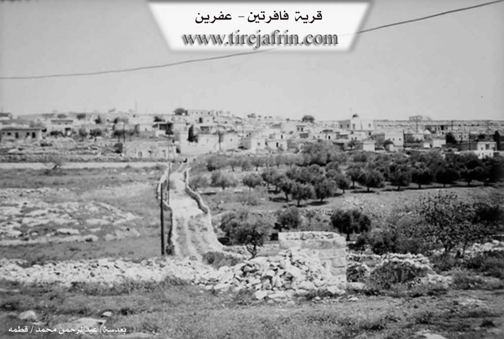
It is a small village of Şêrewa. It contains the remains of the altar of the oldest dated church in Syria from the fourth century AD "372 AD", and beside it is a tomb and an old cemetery. There are two archaeological sites to the south west and south east of it by about 1 km, and they are rich in their many ruins.
The following appeared in the book عفرين .... نهرها وروابيها الخضراء Efrîn... Her River and Her Green Hills by the writer عبدالرحمن محمد Ebdulrehman Mihemed from the village of Qetme:
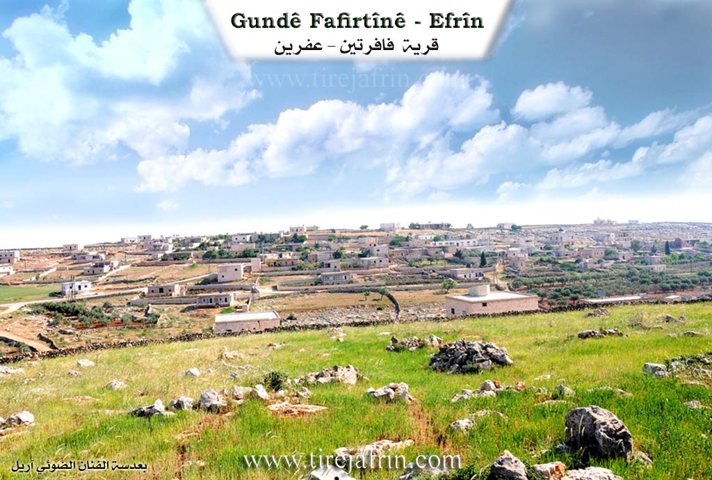
Fafertîn is a village in Çiyayê Semen, following the subdistrict of Nahetiye gundên navend, Efrîn region, Aleppo governorate. It is a large village located on the southern slope of a limestone plateau, in the southern part of Çiyayê Semen north of Çiyayê Rekîm and on the left side of Geliyê Fafertîn which passes south of the village heading towards the south east. It is 30 km away from the city of Efrîn towards the south.
It is surrounded by small fields with alluvial clay soil. The settlement of the area is ancient as evidenced by the presence of ruins in it dating back to the Roman and Byzantine eras, including remains of church walls in addition to tombs and wells carved into the rock, and columns, capitals, and lintels scattered throughout the village.
It is bordered to the north by a rugged mountain range and the village of Kebşîn and Birc Heyder. To the south, a slope and valley and the village of Kefertîn and Qibtan el-Cebel. To the west, a rugged mountain range and the farm of Birc Silêman. To the east, a rugged mountain range and valley and the village of Şêx Eqîl.
The number of its houses reaches about 100 houses and the age of the village is about 400 years. Its old dwellings are made of mud and wood and the modern ones are of stones and reinforced concrete. An electricity network is available there, as well as a modern paved road passing through the center of the village. It has a primary school and a modern mosque.
The residents work in rain fed agriculture on an area of 160 hectares, including "grains", alongside raising sheep and cows. They drink from pools and cisterns and by transport from the waters of neighboring villages when needed. It connects with the city of Efrîn by a paved road and a road passes through its center with a length of 7 km.
Village Mukhtar: Diyab Ehmed
Sources:
- Book: جبل الكرد (عفرين) دراسة جغرافية Çiyayê Kurmênc (Efrîn): A Geographical Study by د. محمد عبدو علي Dr. Mihemed Ebdo Elî.
- Book: عفرين .... نهرها وروابيها الخضراء Efrîn... Her River and Her Green Hills by عبدالرحمن محمد Ebdulrehman Mihemed from the village of Qetme.
Preparation and execution:
- Manager of Tirej Efrîn site: Ebdulrehman Hacî Osman
- 20/12/2013
II. Summary of Fafirtîn from Ax û Welat
Source: https://www.youtube.com/watch?v=dFOk2px_Pxo
Fafirtînê is a historically significant village located in the Şêrawa district of the Efrîn region, situated within the Çiyayê Lêlûn (also known as Çiyayê Kurmênc) mountains. The village's name is locally believed to be derived from "ba firtone" (storm wind), referring to the strong winds that characterize the high-altitude terrain.
History and Origins
The area has a deep historical footprint dating back to the Roman and Byzantine eras, specifically between the 2nd and 7th centuries AD. The village is home to the oldest church (Kinîse) in Syria, a basilica constructed in 372 AD. This site once served as a pilgrimage destination where monks were buried.
The modern settlement of the village is attributed to two founding brothers, Ezdîn and Quriş, from whom the current population descends. Approximately 75 years ago, the village also received migrants from the village of Şêx Aqîl following a conflict with Qubtan el Cebel. Historically, the residents of Fafirtînê were Êzîdî Kurds. However, the community underwent a forced conversion to Islam roughly 60 to 70 years ago. Before this conversion, the villagers buried their dead in the nearby Êzîdî village of Basûfan.
Social Structure and Life
The village describes itself as a single extended family, though it is divided into distinct lineages such as Mala Şêxê, Mala Êlalka, Mala Qesim, and Malê Hano. The local economy is driven by stone quarrying ("kargehên keveran"), livestock rearing, and agriculture, particularly olive and grain farming. The village has a strong communal spirit, with residents actively participating in collective work and defense; seven local martyrs, including Şehîd Şêro and Şehîd Nûjiyan, are honored, and the village communes are named after them.
Landmarks and Features
Fafirtînê is renowned for its immense number of caves. Historical records indicate the existence of 360 caves in and around the village, which were used as primary dwellings by the ancestors of the current residents before stone houses were built. Notable sites within the village include the ancient Kinîse and a ruin known as Keleha Xerab (The Ruined Castle), which contains wine presses and carvings of the sun and grapevines. The surrounding landscape is dotted with other historical ruins such as Batût, Banasor, Sûrk, and Bazêr, and the village lies just 7 kilometers from the famous Kela Semanê (Saint Simeon Stylites).
II. Ax û Walat Book 2
82
FAFIRTÎNÊ
16.1.2017
The village of Fafirtînê is affiliated with the Şêrewa district of the Efrînê canton, located about 30km south of the city of Efrînê. This is the last village of the Şêrewa district, located 7 km from the Se’man castle.
It is expected that the name Fafirtînê means (Fig Fronts). The oldest church in Syria was found in the village of Fafirtînê, and its history dates back to 372 BC.
Quriş and Ezdîn are considered the two founders of the village, meaning they were the first people to settle in the village.
The village of Fafirtînê was built in a historical location where there are many historical things; around 200 caves, a church, and cisterns are still witnesses to its deep history. The thing that attracts attention
83
is that there are historical shapes and symbols on the caves, showing that the village has an ancient history.
To the east is the village of Şêx Aqîl, where 75 years ago, as a result of a war between the village of Qubtan El-Cebel and the village of Şêx Aqîl, many people moved to the village of Fafirtînê and settled there.
To the south, there are 3 ruins: Batût, Banesor, and Sorq. To the west are the ruin of Bazêr, the Se’man castle, and the villages of Birc Silêman and Basofanê. And to the north are the village of Kibêşîn and Birc Heyderê.
The villagers make their living primarily from raising livestock like sheep, goats, and cows, and they sell their products in the markets of the city of Efrînê and provide for their household needs. Besides animal husbandry, some families cultivate olive groves, and the village farmers also plant their fields with wheat, barley, lentils, vetch, and vegetables.
Many people from the village are engaged in the work of stone cutting. Before the Rojava revolution, they worked in foreign countries like Lebanon, but now they work in the stone factories around Efrînê. A number of men and women from the village work in the institutions and bodies of the Autonomous Administration.
There are 7 martyrs from the village:
Şehd Sorxwîn, Bawer, Dijwar, Şêro, Şiyar and şehîd Nûjiyan.
The village commune is named after Ş. Şêro, and the women's commune is named after Ş. Nûjiyan.
84
The Şêrewa region is generally known for its stones and rocks. There are also 7 stone quarries around the village, so most of the village's people work in those quarries.
Agricultural fields are scarce in the village because all the land is rocky, so the village farmers plowed their fields with animals.
Many wars and battles took place in this region. In the past, fighters would hide in the mountains in this region.
The village of Fafirtînê faced many attacks from gang groups, but like many villages in the district, the people of the village heroically rose up against them and, shoulder to shoulder with the YPG and YPJ, broke their attacks and defeated them.
Transcriptions and Subtitles
| Source | Video | Subtitles | Transcript |
|---|---|---|---|
| Ax û Welat 1 | Watch Video | Download SRT | View Transcript |
Possible Village Name Meaning of Fafirtîn
Abdullah Hajjar believes it is a Syriac name meaning "village of fig fruits."
Source: TirejAfrin Site