General Information
Nahiya (Subdistrict)
Cindires
Also Known As
Firêriyê, فريرية
Tribes
Benî Zeyd, Bûsibê
Families, Clans, etc.
Al Emo, Emo

Photos
Basic Information about Firêriyê
Source: Tirej Afrin
Etymology: The name is believed to be a compound of: wide (Fere) and road (R), meaning the Wide Path
Foundation Date/Period: Approximately 200 years ago
Hills: Çiyayê Kurmênc, Çiyayê Seman
Other Landmarks: Çemê Efrîn, Deşta Cindirês, Zelaqa Şerqî, Zelaqa Xerbî
Summaries
I. Summary from TirejAfrin Site (English) of Firêriyê
Source: https://www.tirejafrin.com/site/kura%20afrin%20Cindires%20-%20fireriye.htm
In the book جبل الكرد (عفرين) دراسة جغرافية Çiyayê Kurmênc (Efrîn): A Geographical Study by د. محمد عبدو علي Dr. Mihemed Ebdo Elî: Firriy, Ferîriyê /1554 inhabitants, 13075 hectares, 12km, 195m/:
I believe that the name is a compound of: wide (Fere) and road (R), meaning "The Wide Path."
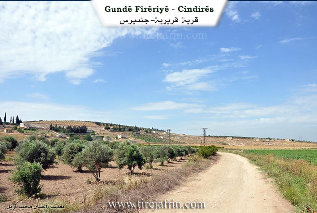
It is a large village located 2km away from Çemê Efrîn. It contains beautiful villas belonging to the sons of Al Emo, and it is considered a main center for them.
In the book: عفرين .... نهرها وروابيها الخضراء Efrîn... Her River and Her Green Hills by the writer عبدالرحمن محمد Ebdulrehman Mihemed from the village of Qetme:
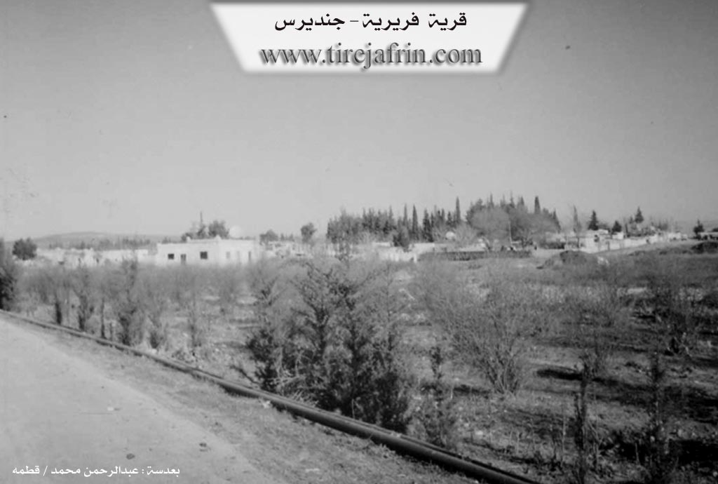
Firriyê: A village in Çiyayê Kurmênc following the Cindirês district, Efrîn region, Heleb governorate. It is a large village located in the eastern part of Deşta Cindirês at a distance of 2km from the valley of Çemê Efrîn to the north. It is 12km away from the town of Cindirês towards the east. Its soil is fertile alluvial, rich in groundwater.
It is bordered to the north by a fertile plain planted with olive trees and the village of Tel Hemû. To the south, a fertile agricultural plain planted with olive trees, the course of the valley of Çemê Efrîn, and the village of Celemê in the far south with the borders of Idlib governorate and Çiyayê Seman. To the west, a fertile agricultural plain and the village of Remadiyê. To the east, a fertile plain planted with olive trees and the village of Kefer Zît on a high mountain rise.
The number of its houses is about 135 houses, and the age of the village is about 200 years according to the statements of one of the village residents. The first to inhabit the village was the Al Emo family, and Rifet Al Emo was among the founders of the village. Its old houses are made of mud, their roofs made of branches and straw on two opposite slopes, while the modern ones are stone and cement. Currently, there are two luxurious villas on the northern side of the village belonging to Dr. Omer Al Emo and his family.
An electricity network is available. The village drinks from a water network connected to the artesian well in the neighboring village of Ghazawiyê. It has a primary and preparatory school, a mosque, a telephone center, an agricultural association, and a party division. A municipality house was established there two years ago. The road from it to Cindirês and the neighboring villages is asphalted.
Two farms follow it: Zelaqa Şerqî and Zelaqa Xerbî. Most of its residents work in the cultivation of olives, grains, and legumes via rainfed farming (1075 hectares) and irrigated farming (300 hectares) by pumping from Çemê Efrîn for the cultivation of sugar beets, pomegranates, and summer vegetables, alongside raising sheep and cows.
Among its most important families: the Al Emo family.
Village Mukhtar: Omer Feyzî Al Emo
Preparation and execution:
Director of Tirej Efrîn website: Ebdulrehman Hacî Osman
20/12/2013
II. Summary of Firêriyê from Multi Channel
Firêriyê is located in the eastern part of the Cindirês plain in the Efrîn region. Initially the village and its surrounding lands were the exclusive property of the Kurdish Emo family, who were the original landowners and local aghas. The historical landscape of the village shifted significantly in the mid twentieth century. Nomadic Arab pastoralists belonging to the Benî Zeyd tribe migrated from Fah, a village in the eastern countryside of Heleb. These pastoralists originally wandered with their camels and small flocks of sheep through various local villages including Cilmê, Îskan, Şadêrê, Xezawiyê, Ebû Keib and Hecîler, before settling in Firêriyê around 1962. The elder Subhî Husên recounts how the villagers previously worked as peasant farmers under the strict rule of the aghas who could evict anyone they pleased. Following the Syrian agrarian reform laws of 1967, the lands previously controlled entirely by these landlords were distributed among the peasant farmers, fundamentally transforming the local social and economic structure and allowing residents to build their own homes and expand their livestock ownership.
Today Firêriyê is home to roughly four hundred families encompassing over five thousand residents. The population is a mix of the indigenous Kurdish landowners from the Emo family and Arab settlers primarily from the Benî Zeyd tribe alongside a few families from the Bûsibê tribe. The village has also recently accommodated around one hundred displaced families from Hema, Seraqib and Meera who live in tents or houses provided freely by the village council. Social cohesion remains strong among the Benî Zeyd members who maintain their traditional Arab folk dances like Welde and Qoser and sing traditional Bedouin songs during local celebrations.
Bordered by Tel Hemo to the north, Cilmê to the south, Keferzîtê to the east and Cindirês to the west, Firêriyê covers about one thousand hectares of fertile alluvial soil. It is located just north of Çemê Efrînê. The local economy relies heavily on irrigated agriculture drawing water from the local dam and artesian wells. Farmers cultivate winter crops like wheat, barley, lentils, cauliflower, cabbage, spinach and radishes as well as summer vegetables and potatoes. Nearly five hundred hectares are planted with olive trees. Animal husbandry is the second major economic pillar with locals raising around five thousand Awassi sheep, several hundred Baladi goats and about one hundred head of cattle. However residents face significant economic hardships today due to high customs fees on trade routes to Daret Izze, expensive fodder, a severe lack of grazing lands and frequent livestock diseases.
Transcriptions and Subtitles
| Source | Video | Subtitles | Transcript |
|---|---|---|---|
| Multi Channel 1 | Watch Video | Download SRT | View Transcript |
Foundation/Origin Information of Firêriyê
The first to settle in the village was the Al Ammu family, who are considered among the founders of the village.
Source: TirejAfrin Site
Possible Village Name Meaning of Firêriyê
Believed to be composed of the Kurdish words for spacious, Fere (فره), and road, Rê (ره), meaning "the wide path" (الدرب الواسع).
Source: TirejAfrin Site