General Information
Nahiya (Subdistrict)
Reco
Also Known As
Gahunda, Gewenda, Kawenda, كاوندة, كاونده, كاوندا, Kaniya Şehîdan
Families, Clans, etc.
Elbiraqa, Hisika, Memşê, Mistkalo, Şêro, Şêxo

Photos
Basic Information about Gewenda
Source: Ax û Welat
Etymology: From the phrase Gah Hinda meaning lost oxen, later Arabized to Gawanda
Foundation Date/Period: Approximately 400 years ago
Springs: Kaniya Defterê
Hills: Çiyayê Mîdana
Shrines: Ziyareta Şêx Mûs
Ruins: Şeqîf
Wells: Sehrînc
Other Landmarks: Meydana, Rezê Çelûçê
Summaries
I. Summary from TirejAfrin Site (English) of Gewenda
Source: https://www.tirejafrin.com/site/kura%20afrin%20%20%20Reco%20-%20Gewenda.htm
The following text appeared in the book: عفرين .... نهرها وروابيها الخضراء Efrîn... Her River and Her Green Hills by the writer عبدالرحمن محمد Ebdulrehman Mihemed from the village of Qetme:
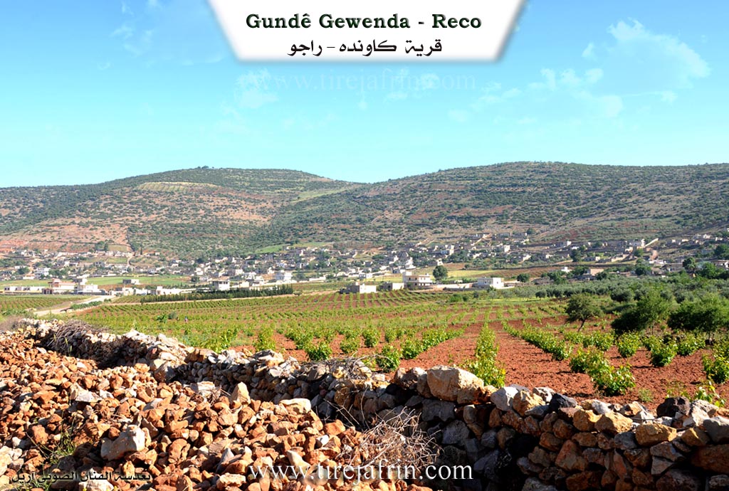
Kawende: A village in Çiyayê Kurmênc following the Reco subdistrict, Efrîn region, Heleb governorate. It is a large village located on the gentle southern slope of Mount Beîfê, which has an elevation of 909 meters in the northwestern part of Çiyayê Kurmênc. It overlooks the alluvial Meydanlî plain from the south and west. It is 20 km away from the town of Reco towards the northeast.
It is bordered to the north by a high mountain range, the Turkish border, and the village of Benderklî. To the south, it is bordered by a fertile plain planted with olive trees, grains, and fruit trees, and the village of Ceylanlî and the village of Bilalîko. To the east, it is bordered by a high mountain range, a deep watercourse, and the village of Şenkilî. To the west, at a distance of 1 km, are the village of Dodo and Şêx Mihemedlî.
The number of its houses reaches approximately 110 houses, and its age is about 500 years. Its old houses are made of stone and mud with flat wooden roofs, while the modern ones are cement and have spread towards the south. An electricity network is available, as well as a drinking water network from a well belonging to the state, a primary school, and a middle school. It is connected to the subdistrict center and neighboring villages by a paved road. There is also a shrine in the southern side of the village among the trees, a water spring, and a cemetery for the village.
The residents work in rain fed agriculture on an area amounting to 386 hectares (olives, grapevines, grains, legumes, summer vegetables), alongside raising sheep and goats. It is one of the Meydaniyan villages. Among the holders of higher degrees in the village: Şêxo Şêxo (PhD in Electrical Engineering, Russia).
Village Mukhtar: Reşîd Mistkalo
Preparation and execution: Manager of the Tirej Efrîn site: Ebdulrehman Hacî Osman 20/12/2013
Sources:
- Book: عفرين .... نهرها وروابيها الخضراء Efrîn... Her River and Her Green Hills by عبدالرحمن محمد Ebdulrehman Mihemed from the village of Qetme.
II. Summary of Gewenda from Ax û Welat
Source: https://www.youtube.com/watch?v=nGDwL6HkeT8
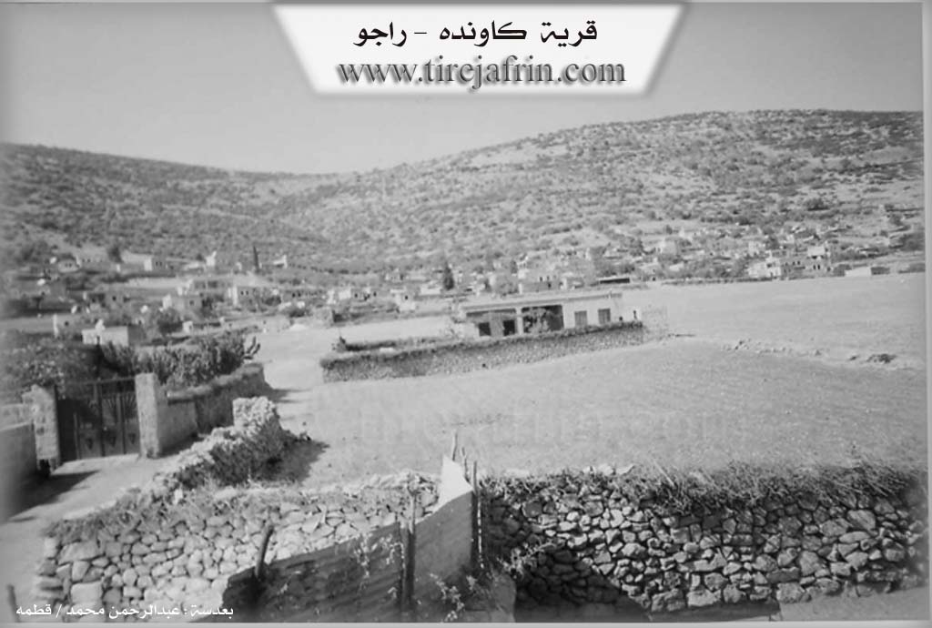
The village of Gahinda, officially known in administrative records as Gawanda, is situated in the Reco district of the Efrîn canton. It is one of seven distinct villages clustered around the Meydana plain, a broad flatland flanked by Çiyayê Mîdana. According to village elder Remzi, the name Gahinda originates from the phrase "Gah Hinda" (meaning "lost oxen"), referring to a legend where settlers' oxen went missing in the area. The Arabization of the region later shifted the pronunciation to Gawanda. The other six villages sharing the Meydana plain are Dûdê, Welîkli, Kurrê, Sêmala, Miskûtlî, and Gazê.
The current settlement was founded approximately 400 years ago. However, the community’s origins trace back to a nearby ancient site called Şeqîf. An elder describes Şeqîf as a significant city or fortress that existed over 1,350 years ago, characterized by defensive walls and cisterns (Sehrînc). The inhabitants were forced to abandon Şeqîf and move about 700 meters to the current site of Gahinda due to successive wars involving the Menxol (Mongols), Teter (Tatars), and Romaniyan (Romans/Byzantines). The modern village was established by four primary families: Hisika, Memşê, Şêro, and Elbiraqa. The Hisikê and Memşê families were already present when the ancestors of the Şêro and Elbiraqa lineages, specifically individuals named Elî and Qasim, migrated from the El Ezîz area.
A central feature of the village's daily life is Kaniya Defterê, a deep water source located in the plain. Although referred to as a spring (kanî), it is a well dug 15 meters deep during the French Mandate period in 1932. It has served as the primary water source for both residents and livestock, specifically designated in the past for watering animals in stone troughs. The village is also renowned for its viticulture, particularly a grape variety called Çelû grown in the Rezê Çelûçê vineyards, which thrive in the iron-rich soil.
The spiritual center of Gahinda is the Ziyareta Şêx Mûs (Shrine of Sheikh Mus). Villagers believe Şêx Mûs was a historical figure or warrior associated with a "lion" (şêr), who was killed in battle and asked to be buried near the Meydana. The shrine is a site of pilgrimage for those seeking cures or fertility. A distinctive ritual involves driving wooden pegs or nails into the wall or nearby trees; if the peg holds firm, it is believed the supplicant’s wish, often for a child, will be granted. Many children in the village are named Şêxmûs in his honor.
In recent history, Gahinda has earned the title Kaniya Şehîdan (Spring of Martyrs) due to the high number of local youth lost in conflicts; residents note that 17 martyrs died in a span of just three years. The village is also known for its traditional culinary customs, such as the preparation of Nanê rûnê, a pastry made with grease and grape molasses, and Vişvişk.
Transcriptions and Subtitles
| Source | Video | Subtitles | Transcript |
|---|---|---|---|
| Ax û Welat 1 | Watch Video | Download SRT | View Transcript |