General Information
Nahiya (Subdistrict)
Cindires
Also Known As
Gorda, Gordan, كوردان, گوردان
Families, Clans, etc.
Cemîl Behrî Kinê, Hec-kebate, Tîto

Photos
Basic Information about Gorda
Source: Ax û Welat
Caves: Şkefta odê
Number of Caves: 40
Trees: Dara Çinarê
Wells: Bîra cîk
Summaries
I. Summary from TirejAfrin Site (English) of Gorda
Source: https://www.tirejafrin.com/site/kura%20afrin%20Cindires%20-%20Gorda.htm
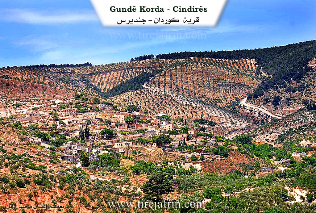
Based on the book جبل الكرد (عفرين) دراسة جغرافية Çiyayê Kurmênc (Efrîn): A Geographical Study by د. محمد عبدو علي Dr. Mihemed Ebdo Elî: Gorda, Gordan /1350 inhabitants - 380 hectares - 15km - 550m/:
It is stated in the Ferhenga Goranî that Gord means a blunt sword that does not cut or kill. The Ferhenga Kurdistan states that it comes from: strength and courage, and is also a marking on certain types of goats. As for Gord as a name for the village, it is the proper name of a woman from the village of Swiya who resided in that location, and it was named after her. Her old place of residence still exists south of the village of Swiya and is called Xirab Gord.
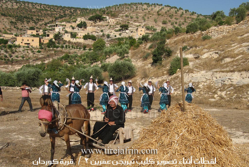
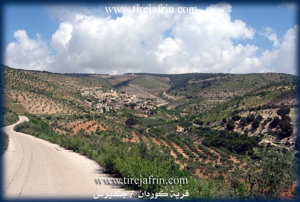
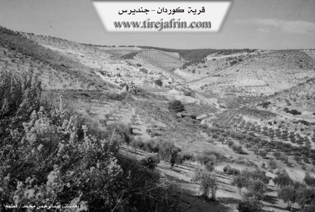
The village is surrounded by mountains from the east, north, and west. On some surrounding peaks, as well as in the village site, there are remains of many ancient ruins. These locations have names: Bena Dirêj (The Long Rise/Height), Poz Kol (The Barren Peak), and Xirab Kortliq, which is also an ancient dwelling place. The current Gordan is a small village located on the western side of the Ola Cehnim valley (Valley of Hell/Death), which is a wooded and rugged valley where those wanted by authorities sometimes take refuge. The village is considered an area rich in archaeological finds, and it contains numerous caves that were used for habitation in ancient times. There is an old water well near the village.
It is stated in the book عفرين .... نهرها وروابيها الخضراء Efrîn... Her River and Her Green Hills by the writer عبدالرحمن محمد Ebdulrehman Mihemed from the village of Qetme:
Kûrdan: A village in Çiyayê Kurmênc, administratively belonging to the Jindirês district, Efrîn region, Heleb governorate. It is a small village located at the southern edge of the middle section of the mentioned mountain block, where a number of gullies descending from the north converge into a single course heading south. It is overlooked by limestone mountain slopes furrowed by gullies. It is 15km away from Jindirês towards the north.
It is bordered to the north by a very deep gully and a high, steep mountain chain planted with olive and forest trees, and the villages of Rûtanlî and Îkî Axûr; to the south by a deep gully heading towards the Jindirês plain and the villages of Miska Jêrîn and Zindakan; to the west by a gully and mountainous heights planted with olive and oak trees and the village of Çobanlî; and to the east by a deep gully, mountainous heights planted with olive and oak trees, and the villages of Xeltanê Rojava and Xeltanê Rojhilat.
The number of its houses reaches 45, and its age is approximately 300 years. Its old houses are stone and mud with flat wooden roofs, while the modern ones are cement, extending north and west along the transportation roads. A electricity network and a primary school are available. There is a Roman water well at the bottom of the village. It is connected to the district center by a paved road reaching the center of the village. The village drinks from the water of old wells in the bottom of the valley on the northern side of the village and from cisterns collecting rain water. Most of its residents work in the cultivation of olives, grains, vines, and figs via rain-fed agriculture (380 hectares) and the raising of sheep and goats.
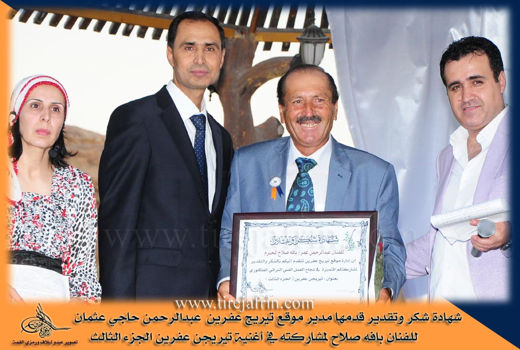
The village site is mountainous, steep, and very rugged. Among its most important families is the Cemîl Behrî Kinê family. It is noted that the popular folkloric artist Ebû Selah is a son of this village - Koma Hawar.
Village Mukhtar: Mihemed Ehmed Xûrşîd
Sources
Book: جبل الكرد (عفرين) دراسة جغرافية Çiyayê Kurmênc (Efrîn): A Geographical Study by د. محمد عبدو علي Dr. Mihemed Ebdo Elî.
Book: عفرين .... نهرها وروابيها الخضراء Efrîn... Her River and Her Green Hills by عبدالرحمن محمد Ebdulrehman Mihemed from the village of Qetme.
Preparation and execution by the manager of the Tirej Efrîn site: Ebdulrehman Hacî Osman.
20/12/2013
II. Summary of Gorda from Ax û Welat
Source: https://www.youtube.com/watch?v=c5LgQVpmUnA
The village of Gorda, situated in the Cindirêsê district of the Efrîn region (historically referred to as Çiyayê Kurmênc), serves as the focal point for the life and legacy of the renowned artist Bavê Selah (born Ebdulrehman Omer). While the transcript does not detail the ancient founding of the village itself, it presents Gorda as a cradle of artistic preservation and resistance against cultural erasure. Bavê Selah was born in Gorda in 1952 and, following his death on July 14, 2016, was laid to rest in the same soil, cementing the village's reputation as the home of a "cultural ambassador" for the Kurds of Rojava.
The social fabric described in the documentary centers on the artistic lineage of Bavê Selah. He did not emerge in isolation but from a "family of art." His mother, Gulîzar Yûsif, was a dengbêj who sang epic songs, and she was the daughter of Ibrahîmê Tirko, a famous dengbêj of the region. This intergenerational transmission of culture was supplemented by Bavê Selah's apprenticeship under Adîk, a master musician from the neighboring village of Kora, who taught him the tembûr. The narrative also highlights the sacrifices of this family; Bavê Selah was the father of seven children, one of whom, Dîvar, joined the Freedom Movement and was martyred.
Gorda and its residents lived under the intense pressure of the Syrian Baathist regime. Bavê Selah was arrested multiple times, with his final detention occurring in 2011, because the regime viewed his preservation of Kurdish history and music as a political threat equivalent to forming a party. A significant portion of his work involved resisting the "Arabization" of the region. Together with colleagues Perîşan, Ebdurehman Hacî Osman, Nûrî Qornehesen, and Şêro Menan, he launched a project called Tîrêj Efrîn. This initiative used music to record and restore the original Kurdish names of villages in Efrîn that the government had officially renamed.
Culturally, the village is associated with the preservation of deep folklore. Through Bavê Selah, the community maintained a connection to historical Kurdish figures and epics, including Memê Alan, Derwêşê Evdî, Melayê Cizîrî, and Feqiyê Teyran. Peers describe Bavê Selah as the "Mandela of Efrîn" and a "library of art," noting that he traveled extensively—from Amed and Cûlemerg (specifically the village of Miskê) to international stages—yet always remained rooted in the heritage of Çiyayê Kurmênc and his home village of Gorda.
II. Summary of Gorda from Ax û Welat 2
Source: https://www.youtube.com/watch?v=AgbS6SPIwOs
The village of Gurda is located in the Cindirêsê district of the Efrîn canton situated within the mountainous terrain of Çiyayê Kurmênc. According to local resident and teacher Ismet the history of the village is deeply ancient and dates back to the era of the Kûtiyan or Gutians approximately 10,000 years ago. He asserts that the village contains archaeological evidence linking it to this prehistoric period and compares it to other historical sites in the region such as Kîmarê and Kûtana. While the village currently comprises about fifty households the residents historically lived in the surrounding mountains. Elders recall that there were previously 40 caves used as homes before stone masonry houses were constructed roughly 300 to 500 years ago.
The social history of Gurda is defined by the specific families and individuals who developed the land. Ismet notes that the Hec-kebate family has deep roots in the village. He lists five specific men responsible for transforming the wild mountainous landscape into agricultural land for olive and fruit trees. These figures include Îbşê Hec-kebe, Emîkê Nêsir, Reşdê Îbê, Hesê Elîkê, and Emerê Şêxê. The village is also known for producing educated and artistic figures. Cemîlê Kinê a noted poet and judge born in 1877 was a native of Gurda. Other notable residents include the intellectual Arif Rêhanî and the female dengbêj known as Gulu who was the mother of the artist Bavê Selah. Ismet also highlights a woman named Zaîde who was among the first educated females in the 1940s when caves served as learning cells.
Daily life in Gurda was traditionally centered around agriculture and the use of natural resources. Villagers formerly used a threshing device called a cercer to process wheat and barley. Water management was crucial in this mountain environment with specific features like Bîra cîk a well that residents sometimes accessed through the cave systems. One specific cave known as Şkefta odê was partitioned for living and stabling livestock. Today the village retains a connection to its environment through practices like beekeeping as detailed by Ciwan. A living monument to the village history is the Dara Çinarê a massive plane tree estimated to be over 250 years old which stands as a central landmark in the community.
Transcriptions and Subtitles
| Source | Video | Subtitles | Transcript |
|---|---|---|---|
| Ax û Welat 1 | Watch Video | Not Available | View Transcript |
| Ax û Welat 2 | Watch Video | Download SRT | View Transcript |
Foundation/Origin Information of Gorda
A woman named Gord from Sêwiya village settled in the location, and it was named after her.
Source: TirejAfrin Site
Possible Village Name Meaning of Gorda
Gord means strength and courage, or marks on goats. The village was named after a woman named Gord who settled there.
Source: TirejAfrin Site