General Information
Nahiya (Subdistrict)
Efrîn
Also Known As
Kîbêşînê, كباشين

Photos
Basic Information about Kîbêşînê
Source: Tirej Afrin
Etymology: The name is believed to be derived from the appearance of Italian monks in Mount Lîlon who wore blue caps; Kub or Kum in Kurdish means cap, while Qub also means dome, and Şn means blue, thus meaning Blue Cap or Blue Dome
Foundation Date/Period: approx 400 years
Hills: Şêrwan, Lîlon, Simean, Cewber
Other Landmarks: Zekiye, Zûq
Summaries
I. Summary from TirejAfrin Site (English) of Kîbêşînê
Source: https://www.tirejafrin.com/site/kura%20afrin%20markaz-%20Kobashen.htm
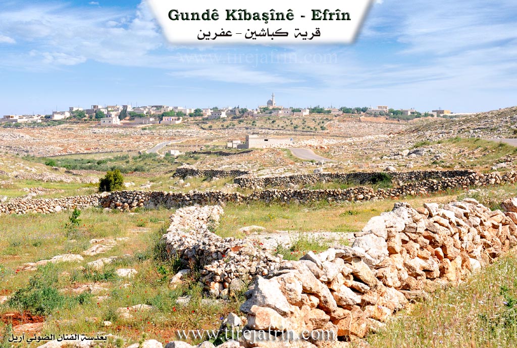
Kibşn, Kibaşîn has 953 inhabitants, covers 258 hectares, is located 37 kilometers away, and sits at an altitude of 545 meters.
It is stated in the book Çiyayê Kurmênc (Efrîn): A Geographical Study by Dr. Mihemed Ebdo Elî regarding Kibaşîn: It is believed that the name "Kibaşîn" is derived from the appearance of Italian monks who used to worship in Mount Lîlon and put on blue caps. Kub or Kum means cap in Kurdish, while Qub also means dome. Şn is in the sense of the color blue. Thus, the word is Kurdish meaning "Blue Cap" or "Blue Dome." In news from 1836, Naum Bakhash mentions in his notebooks (Vol 1, p 49) the existence of a monastery for Maronite Capuchin fathers in Heleb. As for Khuri Barsoum, he says that the name is Aramaic meaning "stallions" or "rams" (p 265), but I believe this is far from correct.
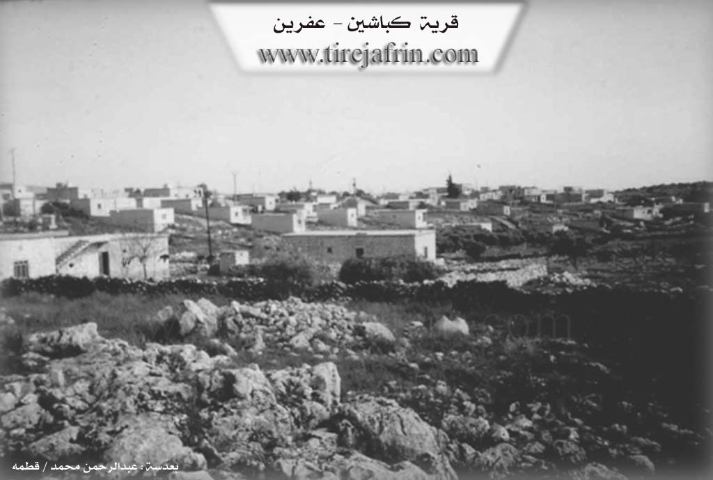
It is a medium sized village among the villages of Mount Şêrwan. It contains archaeological remains including remnants of church walls, lintels, columns, and wells carved into the rock dating back to the Roman and Byzantine eras.
It is stated in the book Efrîn... Her River and Her Green Hills by the writer Ebdulrehman Mihemed from the village of Qetme that Kibaşîn is a village in Mount Lîlon and Simean. It belongs to the Central Villages subdistrict, Efrîn region, Heleb governorate. It is a large village located at the end of the southern slope of Mount Cewber in the southern part of Mount Simean and on the left side of the Zekiye valley which heads from the northwest toward the southeast. It overlooks the Zûq valley from the east and lies to the southeast of Efrîn city at a distance of 30km.
It is bordered to the north by a rugged mountain range of rocks and the villages of Kefernabo and Kalote; to the south by a slope, a valley, a rugged mountain range, and the villages of Fafertîn and Şêx Eqîl; and to the east by a rugged mountain range of rocks and the village of Zûqa Mezin. The number of its houses reaches approximately 90 houses, and the age of the village is approximately 400 years. The settlement of the area is very old, indicated by the remaining ruins of some church walls, lintels, columns, tombs, and wells carved into the rock. These date back to the Roman and Byzantine eras. Its dwellings are stone and mud with wooden roofs, while currently they are of reinforced concrete and stone.
Its residents work in grain cultivation on an area of 258 hectares, as well as raising sheep and cows. An electricity network is available in the village. They drink from a public network that draws its water from a well in the south of the village of Zûqa Mezin, located 3km east of the village. The village contains a primary school, a mosque, a modern villa located on the eastern side of the village, and a health center. It is connected to Efrîn city by an asphalt road.
Village Mukhtar: Mihemed Heyder Ehmed
Sources:
- Book: جبل الكرد (عفرين) دراسة جغرافية Çiyayê Kurmênc (Efrîn): A Geographical Study by د. محمد عبدو علي Dr. Mihemed Ebdo Elî.
- Book: عفرين .... نهرها وروابيها الخضراء Efrîn... Her River and Her Green Hills by عبدالرحمن محمد Ebdulrehman Mihemed from the village of Qetme.
Preparation and Execution:
- Manager of Tirej Efrîn site: Ebdulrehman Hacî Osman
- 20/12/2013
II. Summary of Kîbêşînê from Ax û Welat
Source: https://www.youtube.com/watch?v=Z-wjWSw2Edg
The village of Kibêşîn is located in the rocky mountain terrain of Çiyayê Lêlûn within the broader Herêma Şêrewa region. According to local elders, the ancestors of the village originally migrated from Şengalê in the eastern region. Upon arriving in the area, they initially lived in tents and local caves, specifically at a site called Şikeftê Berxika. This early settlement was located opposite the current village on slopes referred to as Baniyê Gund, Baniyê Pêşî, and Baniyê Hember. The modern village area itself contains 28 caves where residents also lived in the past.
To build permanent homes, the villagers gathered stones at night from nearby areas such as Basfanê and the ruins of Kela Semanê. Because the area lacks soil, they constructed unique stone domed houses. During the spring, wild grass would grow on these stone domes, giving them a green or blue appearance. As a result, neighboring settlements called the village Quba Hişîn or Quba Hecşîna, meaning Blue Domes. Later, state authorities officially altered the name to Kibêşîn.
Geographically, Kibêşîn is surrounded by Arab villages to the east, south, and west. These include nearby towns like Nubul, Zehra, Heyan, Eledanê, Qibtanê, and Darizê. Despite this, the villagers historically maintained a strong Kurdish identity and aligned themselves politically and administratively with Efrîn, which is 23 kilometers away. A past village leader explicitly refused government attempts to transfer their administrative registry to Ezaz, insisting that their people belonged with Efrîn. During recent conflicts, the youth of the village, alongside the YPG, defended their lands at locations like Tepe Sekînî.
The landscape is completely composed of solid rock. Unlike other parts of the region such as Deşta Cûmê or Deşta Hemqê, olive trees do not thrive here. Instead, the local economy relies heavily on raising sheep and cows. Agriculture is exceptionally arduous. Villagers plow the rocky soil using a specialized single animal setup called an ebcar to plant wheat, barley, lentils, vetch, and apple trees.
In the past, village weddings lasted for three days, featuring drums and communal dancing. Singers would perform traditional songs without microphones. Due to the high number of guests visiting the village, every household maintains a tandoor oven specifically to bake traditional sesame pastries called kade. In the spring, the villagers forage for a variety of wild edible herbs to make meals, including derzîdank, tolik, nankê çûkê, kerbeş, xardel, sîbûnik, tahlo, and çaqir.
Transcriptions and Subtitles
| Source | Video | Subtitles | Transcript |
|---|---|---|---|
| Ax û Welat 1 | Watch Video | Download SRT | View Transcript |
Possible Village Name Meaning of Kîbêşînê
Believed to be derived from Italian monks who wore blue caps (Kurdish: Kub/Kum = cap, Şîn = blue). Another opinion is that it is Aramaic meaning: the males, the rams.
Source: TirejAfrin Site