General Information
Nahiya (Subdistrict)
Bilbilê
Also Known As
Kerê, صاغر, صاغر اوبه سي
Tribes
Jernasî

Photos
Basic Information about Kerê
Source: Afrin 366
Etymology: Originally called Tilê Guh Vêş or Gola Guh Vêş; currently known as Erebê Karrê or Karrê
Hills: Tilê Guh Vêş
Summaries
I. Summary from TirejAfrin Site (English) of Kerê
Villages of Bilbile District / bilbile
Şāġir Oba Si (صاغر اوبه سي) - Gu. Kerê
===
According to the book 'جبل الكرد' 'Mountain of the Kurds' / Afrin City / Geographical Study:
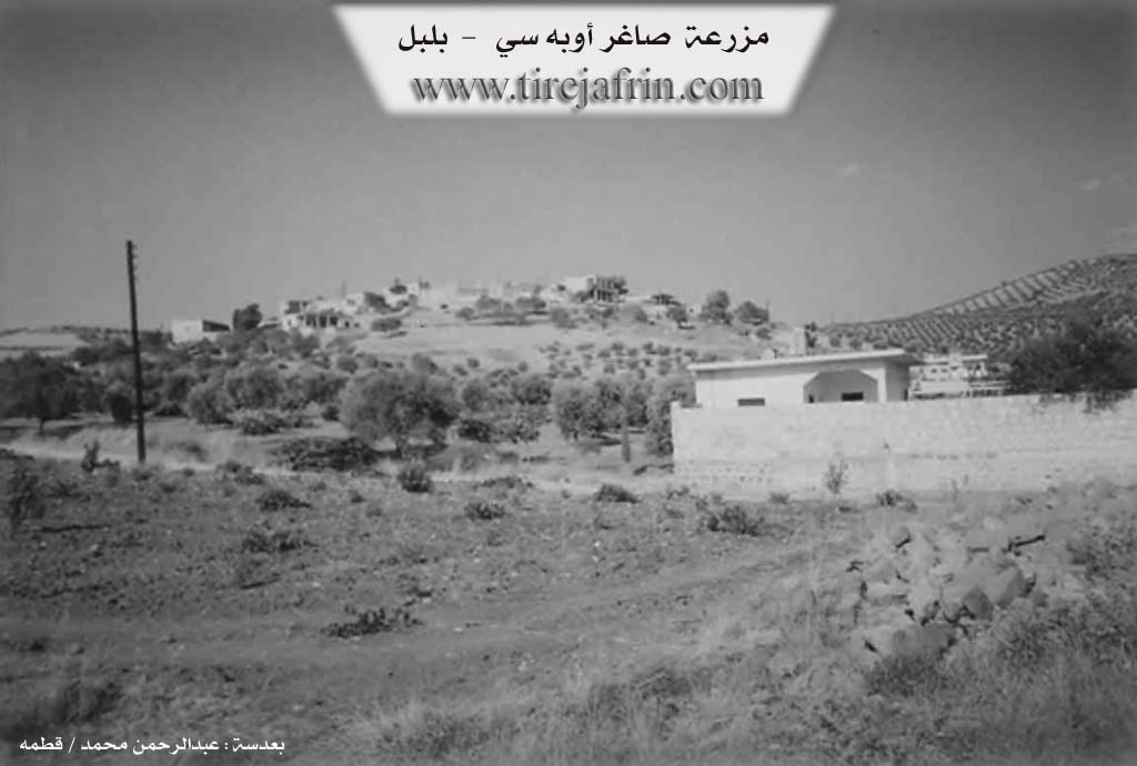
Gundî Kerê, Şāġir Oba Si (صاغر أوبه سى), Şāġir (صاغر) /1142N- 20km - 200E - 630m/:
- The name means "deaf" in Kurdish, and it is a nickname for its first inhabitant. The Ottoman name means "deaf people's community."
- A small village located on the southeastern slope of a mountain elevation, Jarqa Valley (وادي جرقا) flows to its south.
According to the book: Afrin... Her River and Green Hills:
Şāġir Oba Si (صاغر اوبه سي): A village in Kurdistan Mountain (جبل الكرد) belonging to Bilbile District (ناحية بلبل), Afrin (منطقة عفرين), Aleppo Governorate (محافظة حلب).
It is a medium-sized village established on a rocky plateau on the southeastern slope of Kilsi Mountain (جبل كلسي) located in the central and north-central part of the aforementioned mountain mass, surrounded by streams that feed Jarqah Valley (وادي جرقة) to its south, 20km away from Bilbile town (بلدة بلبل) to the southwest. It overlooks from the south-west and west its agricultural lands with fertile clay soil. It is bounded to the north by a rough rocky mountain chain and oak trees and Kurzîl Bilbile village (قرية كورزيل بلبل), to the south by a slope and the Rajo-Kotānlī road (طريق راجو كوتانلي) and nearby Ashūnah village (قرية عشونة) 500m away, to the west by Sîlî Valley (وادي سيلي) and a mountain chain and Kîlānlī village (قرية كيلانلي), and to the east by a rough mountain chain and Qotānlī village (قرية قوطانلي). The number of houses is 50 houses and its age is approximately 300 years. Its old dwellings are stone-clay with flat wooden roofs, and the modern ones are concrete that extended to the southeast and are increasing. It has an electricity network, an elementary school, and a modern olive press. The village drinks from artesian wells and from cisterns that collect rainwater. Most of its inhabitants work in cultivating olives, grains, and vines rainfed on an area of /200/ hectares, in addition to raising sheep and goats. It is connected to Bilbile town (بلدة بلبل) by a paved road that passes near it to Rajo town (بلدة راجو).
Village headman: Rashīd Ibrāhīm (رشيد ابراهيم)
Sources:
- Book 'جبل الكرد' 'Mountain of the Kurds' (Afrin City) Geographical Study by Dr. Mohammed Abdo Ali (الدكتور محمد عبدو علي).
- Book: Afrin... Her River and Green Hills by writer Abdul Rahman Mohammed (عبدالرحمن محمد) from Qatmah village (قرية قطمه).
- Studies by Tîrêj Soft Center (مركز تيريج سوفت) / Abdul Rahman Haji Osman (عبدالرحمن حاجي عثمان)
- Some village residents.
Prepared and executed by: Tîrêj Afrin website manager: Abdul Rahman Haji Osman (عبدالرحمن حاجي عثمان)
20 / 12 / 2013
II. Summary of Kerê from Afrin 366
Source: https://www.youtube.com/watch?v=bGOEpCFTum0
The village of Erebê Karrê (also frequently referred to simply as Karrê) is located in the highlands of the Afrin region. While the village administratively belongs to the district of Bilbilê (approximately 25 kilometers away), the residents note that it is geographically much closer to Raco, which is only about 10 to 12 kilometers away. The village is situated in a cold, mountainous area where heavy snows are known to block roads, requiring machinery to clear them.
The oral history of Erebê Karrê describes a migration that originated far from the region. According to an elder interviewed in the documentary, the ancestors of the current residents came from Şengal (Sinjar). They belonged to the Jernasî line (branch/tribe). The migration was prompted by hardship in their homeland; the elder speaks metaphorically of their lands becoming "black" or ruined ("Melkê wî li wir reş bûn"), forcing them to rise and migrate ("Em serî hildin ko bibin"). Upon arriving in their current location, they established scattered homes before eventually consolidating into the village seen today.
Before acquiring its current name, the location was known as Tilê Guh Vêş or Gola Guh Vêş. The term "Til" suggests the settlement was associated with a mound or hill. The village maintains a strong historical or administrative connection to the nearby village of Benaviyê; at one point in the transcript, a resident identifies the location essentially as "Gund Benaviyê," suggesting Erebê Karrê may be considered an extension or satellite of the larger Benaviyê community.
Structurally, the village is comprised of approximately 85 households. It features traditional stone architecture, including courtyards dating back to the mid-20th century (one specific house is noted as being built in 1952). There is a mosque in the village, situated near a water drainage system described by the host. The local economy is tied to agriculture, specifically the olive harvest, with residents discussing the fluctuating prices of olive oil tins.
Socially, the older generation reflects on the changes in the community. They contrast the "past", which was characterized by fear and insecurity but possessed wealth, youth, and robust social bonds, with the "present," which offers more safety but lacks the "taste" (tehm) or social cohesion of the old days. The residents lament that while material conditions and safety may have improved, the deep interpersonal value ("qîmet") people once held for one another has diminished.
Transcriptions and Subtitles
| Source | Video | Subtitles | Transcript |
|---|---|---|---|
| Afrin 366 1 | Watch Video | Download SRT | View Transcript |
Possible Village Name Meaning of Kerê
The name means "deaf" in Kurdish, and it is a nickname for its first inhabitant. The Ottoman name Şāġir Oba Si means "deaf people's community."
Source: TirejAfrin Site