General Information
Nahiya (Subdistrict)
Reco
Also Known As
Musik, Musiya, Mûskê, موسيك اوبه سي, موسيكو, موسيه
Tribes
Mûsa Beg
Families, Clans, etc.
Boxrî, Mala Ebu Hemdo, Mala Meyrîtê, Malbata Mirawol, Malê Ebû Osman, Malê Hesenin, Malê Muxtar, Malê Wehbe Merî, Malê Xalo, Malê Xalê Mirî, Mûso

Photos
Basic Information about Mûskê
Source: Afrin 366
Foundation Date/Period: 300 years ago
Springs: Avê Kergû, Kahnok
Hills: Hurata, Hişnav, Sêlavtolyê, Pşê malê, Sahala jûr
Ruins: Hurata
Other Landmarks: Sah a Kelvrê, Dukanê xalê Mirî
Summaries
I. Summary from TirejAfrin Site (English) of Mûskê
Source: https://www.tirejafrin.com/site/kura%20afrin%20%20%20Reco%20-%20Muska.htm
Village Mûsêk, Mûsêk Obasî, Mûsiyê
2590 inhabitants, 126 hectares, 4 km, 750 m elevation
It is stated in the book Çiyayê Kurmênc (Efrîn): A Geographical Study:
The first person to reside in that location and found the village was named "Mîso Mîsk", which is a verbal variation of the name "Mûsa", and the village derived its name from him. The meaning in Ottoman writing implies "Group of Mûsêk". Furthermore, "Mûsa Beg" is a large Kurdish tribe found in Kobanê (Ayn al Arab), Qamişlo, and Southern Kurdistan. There is a town with the same name (Mûsa Beg) on the Turkish side near the city of Kilîs, which is currently the center of a district.
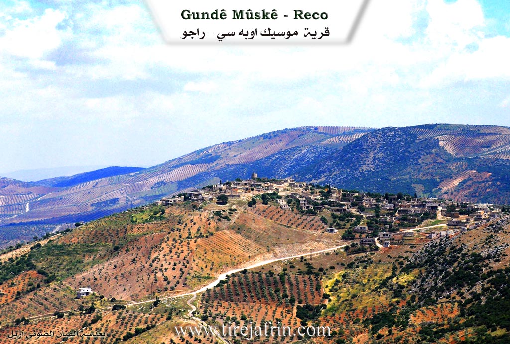
It is a small village located on the northern slope of Çiyayê Etmana. Its slopes descend steeply toward the west, north, and east.
It is stated in the book Efrîn... Her River and Her Green Hills: Mûsêk is a village in Çiyayê Kurmênc belonging to the Reco district, Efrîn region, Heleb governorate. It is a large village situated atop a rolling rocky elevation on the northern slope of a limestone mountain. Its slopes descend steeply toward the west, north, and east. Its soil is clay. It is 4 km away from the town of Reco in the south east direction.
It is bordered on the north by a harsh slope, a railway line, the town of Reco, and the village of Hec Xelîl. It is bordered on the south by a rugged rocky mountain range and the villages of Hemşilê and Behdîna. It is bordered on the east by a deep valley called Geliyê Teyra and the villages of Şêx Bîlal and Golya Jorîn. It is bordered on the west by a slope, a valley, a high mountain range, and the village of Derwîş Obasî.
The number of its houses is about 100 and its age is about 350 years. Its old dwellings are of stone and mud with flat wooden roofs, while the modern ones are cement and have extended toward the east and the outskirts. An electricity network is available in the village. The village drinks from pools and cisterns dug in the homes which store winter rainwater, while others have dug artesian wells for drinking water.
The residents work in rain fed agriculture (olives, vines) on an area of 126 hectares on the adjacent slopes. They raise sheep and goats. The village connects with the township and the region via a leveled dirt road that is not paved. The village is divided into two parts: The Upper Section located in the northern side and the Lower Section in the southern side.
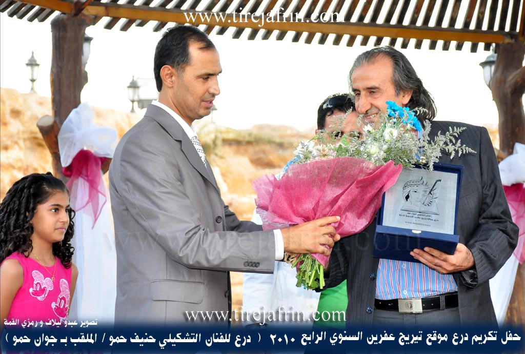
Among its most important families are the Mûso family (Heme Mûske) from the Kobanê area (the first who founded the village), and the village was named Mûsêk in relation to them. Also the Boxrî family. It is mentioned that the plastic artist Henîf Hemo, Ibrahîm Hemo, the guitarist Mistefa Hemo, (Ismet Izet and Mihemed Hemo) who are among the founders of folklore groups in Efrîn, the artist Salih Şadyar, and the organ player Ibrahîm Henan are sons of this village.
Village Mukhtar: Osman Nûrî Husên
Sources of Information:
- Book: جبل الكرد (عفرين) دراسة جغرافية Çiyayê Kurmênc (Efrîn): A Geographical Study by د. محمد عبدو علي Dr. Mihemed Ebdo Elî.
- Book: عفرين .... نهرها وروابيها الخضراء Efrîn... Her River and Her Green Hills by عبدالرحمن محمد Ebdulrehman Mihemed from the village of Qetme.
- Studies of Navenda Tîrêj Soft / Ebdulrehman Hacî Osman.
- Some residents of the villages.
Preparation and execution: Director of the Tîrêj Efrîn website: Ebdulrehman Hacî Osman 20/12/2013
II. Summary of Mûskê from Afrin 366
Source: https://www.youtube.com/watch?v=Rp5LvAxgV1c
The village of Mûskê (occasionally referred to as Mîskê) is located in the Reco district of the Afrin region, situated geographically below the village of Dewrîş. According to the village elder, Ebû Osman (referred to as Xalo), the community has a known history spanning approximately 300 years. He recounts a lineage where his father and grandfather both lived to be 100 years old, linking the current generation directly to the village's earlier eras. Historically, the economy of Mûskê was defined by the production of charcoal (kûmir) and the raising of livestock (pez). Over time, the village experienced development and agricultural shifts, transitioning toward the cultivation of olive trees (zeytûn) and orchards.
The social structure of Mûskê has evolved significantly. While the village originally consisted of about 110 households, the number has grown to approximately 210. However, actual residency has declined due to emigration; only about 50 households currently reside within the village, while roughly 150 families have relocated to Haleb (Aleppo). The documentary highlights a scattered diaspora, with former residents now living in Lubnan, Alemaniya, and Fransa. Specific families and houses mentioned include Malbata Mirawol, Malê Wehbe Merî, Mala Ebu Hemdo, Malê Hesenin, and the family of the headman, Malê Muxtar.
The landscape of Mûskê is marked by specific named localities. The filming team travels through areas such as Hurata, which contains ruins and old houses, and Hişnav (corrected by a local from the name Sêmoncê). Other notable spots include Sêlavtolyê, Pşê malê, and Sahala jûr. The terrain is compared to Sah a Kelvrê, another regional landmark. Water scarcity is a noted issue; while tankers now supply water, residents recall historical water sources like Avê Kergû and Kahnok. Infrastructure improvements were previously made by people from Kimsûrê, particularly regarding the road, though it remains difficult to traverse.
Culturally, the village retains traditional knowledge, particularly regarding hunting. Xalo describes the practice of catching partridges (kew) using nets (daf). This activity typically takes place in Sibat (February) when the birds pair off. The residents also maintain traditional culinary practices, preparing sorma (stuffed vegetables) and frîk (green wheat), while noting a health-conscious avoidance of sugar. The village contains basic amenities, including a school (mekteb) serving up to the sixth grade, a mosque (camî), and a shop known as Dukanê xalê Mirî. Despite the challenges of depopulation and difficult roads, the remaining residents express a deep emotional connection to their ancestral land.
Transcriptions and Subtitles
| Source | Video | Subtitles | Transcript |
|---|---|---|---|
| Afrin 366 1 | Watch Video | Download SRT | View Transcript |
Foundation/Origin Information of Mûskê
Among its most important families: Âl Muso Hamah Muska from Ain Arab region the first to establish the village.
Source: TirejAfrin Site
Possible Village Name Meaning of Mûskê
The first person to settle in that location and establish the village was called "Miso - Misk", a dialectal variation of the name "Musa", and the village derived its name from him. The Ottoman writing means "Musk's group". Musa Bik is also a large Kurdish tribe. The village was named Musik after its founders.
Source: TirejAfrin Site