General Information
Nahiya (Subdistrict)
Cindires
Also Known As
Madaya, Medaya, Midaya, فيلك, مدايا
Tribes
Gewenda
Families, Clans, etc.
Alparaqo, Apûlaro, Hemîd Axa Fîlk, Hesenkê, Mala Keliha, Mala Mihê Omer, Mala Qêwilo, Mala Seyîdo, Mala Şebî, Mihê Mistê, Şero

Photos
Basic Information about Medaya
Source: Tirej Afrin
Etymology: The name approaches the Arabic pronunciation
Foundation Date/Period: 150 years
Summaries
I. Summary from TirejAfrin Site (English) of Medaya
Source: https://www.tirejafrin.com/site/kura%20afrin%20Cindires%20-%20filik.htm
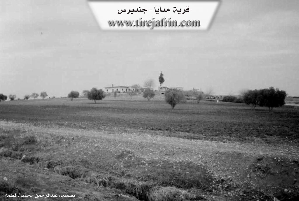
It is stated in the book جبل الكرد (عفرين) دراسة جغرافية Çiyayê Kurmênc (Efrîn): A Geographical Study by د. محمد عبدو علي Dr. Mihemed Ebdo Elî: Gund Flik, village of Feylek /160m/:
It was founded by the so called Fîlik from the village of Birmice, and he was an agent for the Aghas, so he built several houses for residence on agricultural lands that were belonging to them, and it was named after him.
It is located opposite Dîwan Tehtanî on the right bank of the river Efrîn, and it was abandoned in the seventies of the last century after the application of the Agrarian Reform Law.
And it is stated in the book: عفرين .... نهرها وروابيها الخضراء Efrîn... Her River and Her Green Hills by the writer عبدالرحمن محمد Ebdulrehman Mihemed from the village of Qetme:
Fîlik: A farm in the valley of the river Efrîn near the western Çiyayê Seman range following the township of Cindirês, region of Efrîn, governorate of Heleb.
It is a small farm located opposite the village of Dîwan Tehtanî on the right bank of the river Efrîn founded by the so called Fîlik from the village of Birmice affiliated with the township of Mabeta and it was named after him.
It is bordered on the north by a fertile agricultural plain planted with olive trees and the town of Cindirês; and on the south at a distance of 500m the course of the river Efrîn and Dîwan Tehtanî in the far south; and on the west an agricultural plain and the village of Medaya; and on the east the course of the river Efrîn and the village of Tel Selûr.
Currently, the inhabitants abandoned it in the seventies of the twentieth century and there is no one in it, and it consists of agricultural land near the river Efrîn.
Preparation and execution:
Manager of the site Tirej Efrîn: Ebdulrehman Hacî Osman
20/12/2013
Sources:
- Book: جبل الكرد (عفرين) دراسة جغرافية Çiyayê Kurmênc (Efrîn): A Geographical Study by د. محمد عبدو علي Dr. Mihemed Ebdo Elî.
- Book: عفرين .... نهرها وروابيها الخضراء Efrîn... Her River and Her Green Hills by عبدالرحمن محمد Ebdulrehman Mihemed from the village of Qetme.
II. Summary of Medaya from Multi Channel
The documentary explores Meydanê, a village located near the border of Tirkiye in the Raco district of the Efrîn region. Historically, this broader region was known during the Ottoman era as Cebel Ekrad. According to local elders, Meydanê was founded between 300 and 500 years ago. It is actually a cluster of seven smaller settlements collectively called Meydaniyat. These include Gewenda, Gundê Dodo, Wekîlkosê, Gundê Gazê, Gundê Kerê Şêx Mihemedlî, Miskûtlî, and Sêmala.
The primary tribal group in the area is the Gewenda tribe. Within this tribe, several families reside. The two largest families are the Alparaqo and the Şero. Other notable families include Hesenkê, Mala Keliha, Apûlaro, Mala Qêwilo, Mala Şebî, and Mala Seyîdo. Local history traces the roots of the Mihê Mistê lineage back to an ancestor named Alo, who had three sons named Hesen, Silêman, and Omer.
The area is steeped in ancient history. Above the village of Gewenda lie the ruins of an ancient city known as Şeqîf. Locals state that Şeqîf was a major settlement thousands of years ago, and its massive stone blocks and structural foundations are still visible today. The region is also home to sacred sites. The oldest is Ziyareta Hecer. Another highly revered site is Ziyareta Şêx Mûsê Enzelî. According to local legend, Şêx Mûsê Enzelî fled from oppression and hid in an oak forest near the village. He was martyred and buried there. The landscape holds memories of his flight, particularly a hill named Girê Donxiz.
Today, Meydanê is renowned for its agricultural heritage, specifically its traditional grape products. Villagers like Behrî Bekir and Şaban Şêxo process local grape varieties like Dûkilkan and Mûş to make natural sweets. These include sunciq, dimis, basteq, and qerme. The residents take immense pride in preserving these ancient natural methods which are passed down through generations. The village women also keep culinary traditions alive by preparing a local stuffed dish called qabilme using traditional molds and ovens.
Despite its rich culture, the village faces modern hardships. Locals express frustration over the poor condition of the main commercial road connecting Meydan Ekbes to the outside world. Furthermore, many educated residents have fled to places like Ewropa, Almanya, and Rûsya due to conflict and lack of opportunity. Among the notable figures mentioned from the village are Mihemed Şêxo, Umer Şêxo, Ustad Beşîr, and Ebdilrezaq Mistikalo. Despite the mass emigration, the remaining elders remain deeply attached to their ancestral land, emphasizing their enduring identity.
Transcriptions and Subtitles
| Source | Video | Subtitles | Transcript |
|---|---|---|---|
| Multi Channel 1 | Watch Video | Download SRT | View Transcript |
Foundation/Origin Information of Medaya
It was inhabited in the early last century and was a village belonging to Hamid Agha Vilk. The old village became abandoned. Recently, one of the residents bought it and built three houses on it.
Source: TirejAfrin Site
Possible Village Name Meaning of Medaya
The name is close to the Arabic pronunciation.
Source: TirejAfrin Site