General Information
Nahiya (Subdistrict)
Şera
Also Known As
Al-Mahbaba, Naz Ushaghi, Naza, المحببة, ناز اوشاغي, نازو اوشاغي, نازاه
Families, Clans, etc.
Elkûre, Mihemedoka, Rabna

Photos
Basic Information about Naza
Source: Afrin 366
Shrines: Nebî Hûrî
Ruins: Kela Hûrî
Other Landmarks: Meydankê, Hesen Dêra, Geliyê Tîra, Dêwrîş, Derimbilbilê, Eşrefiyê
Summaries
I. Summary from TirejAfrin Site (English) of Naza
Source: https://www.tirejafrin.com/site/kura%20afrin%20%20sheran%20-%20naza.htm
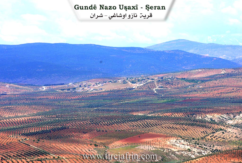
The following is stated in the book جبل الكرد (عفرين) دراسة جغرافية Çiyayê Kurmênc (Efrîn): A Geographical Study: Naza, Naz Uşaxî, the beloved. Population: 1873. Altitude: 500m. Distance: 4km.
Naza: A compound name consisting of two words. "Naz": a female proper noun meaning pampering or delight; and "an": meaning mother. The full meaning is: "Mother Naz." The Ottoman name is Naz Uşaxî, meaning "Children of Naz."
It is a medium sized village, known for its many singers in both ancient and modern times, such as Hes Naz, 'Evd Şe'r, Ebû Idrîs, and others.
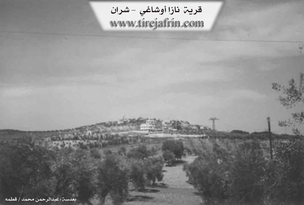
As stated in the book عفرين .... نهرها وروابيها الخضراء Efrîn... Her River and Her Green Hills: Naz Uşaxî is a village in Çiyayê Kurmênc, administratively belonging to the Şeran district of the Efrîn area, Heleb governorate (1959 inhabitants). It is a large village located in the northern part of the mentioned mountain, on the eastern slope of a limestone plateau. It overlooks an alluvial plain to the east that descends slowly towards the valley of Çemê Efrîn (Afrin River). It is located 9 km northwest of the town of Şeran.
It is bordered to the north by a slope, a valley, and a mountain range planted with forest trees, as well as the villages of Bîlê and Qizilbaş. To the south, it is bordered by a wide, fertile agricultural slope, the valley of Çemê Efrîn (Afrin River), and the town of Meydankê. To the east, there is a slope and a valley planted with olive trees and the village of Qerqîna Piçûk. To the west, there is a slope planted with olive trees, the village of Hesen Dêra, and the Riya Bilbil-Meydankê (Bilbil Meydankê road).
The number of houses is approximately 85, and its age is about 400 years according to the accounts of the village residents. Its old dwellings are made of stone and mud with flat wooden roofs, while the modern ones are made of stone and reinforced concrete. An electricity network and drinking water belonging to the state are available due to the presence of a water tank in the center of the village. A paved road reaches the center of the village and continues from there to Kela Nebî Hûrî (Castle of Nebî Hûrî). The village contains a primary school and a mosque. Administratively, it belongs to the municipality of Meydankê and has telephone service.
The residents of the village work in the cultivation of olives and vines and in raising sheep. There are also two modern olive presses at the bottom of the village. The village is one of the old villages in the center of the subdistrict and the region.
Among the families present in the village are: the Elkûre family, the Mihemedoka family, and the Rabna family. There are many holders of university degrees and institute diplomas.
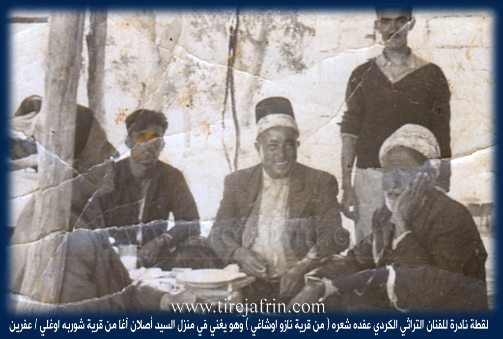
It is mentioned that the fighter Xelîl Hecî Xelîl (Xal Rebano), Ehmed Hesen, Îbiş Xelîl, and Arif Xelîl were among the individuals who resisted the French occupation (from the Murid movement), as mentioned to our site by Mr. Ismet Xelîl, a son of this village. It is also mentioned that the folk heritage artist 'Evdê Şe're and Hesen Nazê are sons of this village.
Village Mukhtar: Zekeriya Xelîl Henan.
Sources of Information:
- Book: جبل الكرد (عفرين) دراسة جغرافية Çiyayê Kurmênc (Efrîn): A Geographical Study by د. محمد عبدو علي Dr. Mihemed Ebdo Elî.
- Book: عفرين .... نهرها وروابيها الخضراء Efrîn... Her River and Her Green Hills by عبدالرحمن محمد Ebdulrehman Mihemed from the village of Qetme.
- Studies of Navenda Tirej Soft / Ebdulrehman Hacî Osman.
- Some residents of the villages.
Preparation and execution: Site Manager of Tirej Efrîn: Ebdulrehman Hacî Osman 20/12/2013
II. Summary of Naza from Afrin 366
Source: https://www.youtube.com/watch?v=QPR2XCICahM
The documentary profiles the village of Nozo (also referred to as Nazo), situated in the Efrîn region of northwestern Syria. Geographically, the village is located approximately 10 kilometers from the city center and about 2 to 3 kilometers from Meydankê. It sits in a scenic location with clear views of the surrounding landmarks; residents and the host note that the road to Nebî Hûrî and the site of Kela Hûrî (Huri Castle) are visible from the village, as well as the nearby Geliyê Tîra (Valley of Tîra).
Historically, Nozo displays a mixture of ancient heritage and modern development. The host highlights a specific "hewşek kevnar" (ancient courtyard/house) which bears an inscription of the year 1382, suggesting a deep historical footprint in the area. Traditional earthen architecture ("xaniyê axê") stands alongside newer construction. An elder named Ebû Mihemed, aged 67, estimates that the village contains between 140 and 150 households ("hewş"). However, the documentary emphasizes the emptiness of the village, with many homes locked ("bapê kilîte") and a significant portion of the population living in the diaspora, particularly in Tirkiyê and Kurdistan.
The village economy is deeply rooted in olive cultivation. The transcript depicts the olive harvest in detail, showing workers hand-picking the fruit ("zêtûn"). Notably, many of the workers harvesting the land in Nozo are originally from the neighboring village of Hesen Dêra, indicating strong regional labor ties. Additionally, the village has an entrepreneurial spirit; a textile workshop run by a local named Ebû Şêro is featured. This workshop employs 10 to 15 people and produces items like hat liners ("kume çokate"). While the host mentions being in Eşrefiyê during the workshop segment (likely a district or location where the villager's business is based), the owner is explicitly identified as a villager of Nozo.
Socially, the village is defined by its close-knit relationships with neighboring communities like Derimbilbilê, Dêwrîş, and Meydankê. Throughout the recording, residents express a poignant longing for their displaced relatives, sending greetings to family members named Enes, Zekeriya, and Ehmed who are living abroad. The village is portrayed as a place of natural beauty ("tebîetê şêrîn") and agricultural abundance, though currently quiet due to the displacement of its original inhabitants.
Transcriptions and Subtitles
| Source | Video | Subtitles | Transcript |
|---|---|---|---|
| Afrin 366 1 | Watch Video | Download SRT | View Transcript |
Possible Village Name Meaning of Naza
A compound name of two words "Naz" a feminine proper name meaning affection; and "an": meaning mother, so the complete meaning is: "Mother Naz". The Ottoman name, Naz Ushaghi, means "children of Naz".
Source: TirejAfrin Site