General Information
Nahiya (Subdistrict)
Mabeta
Also Known As
Goçera, Gu.Omo, Mala Sini, Omo, Umo, اومو, مالا سيني, گوچَرا
Tribes
Delikî, Goçer, Icêlî, Koçera
Families, Clans, etc.
Balo, Bazo, Bozo, Cûno, Delo, Hatino, Hemdî, Kulîko, Mala Delo, Mala Elî Ereb, Mala Heco, Mala Hemdê, Mala Henî Silo, Mala Mela, Mala Mihemedî Sîno, Mala Mixtar, Mala Omo, Mala Xalê Remzî, Omo, Reşo, Silo, Sîno

Photos
Basic Information about Omo
Source: Afrin 366
Foundation Date/Period: 350-500 years ago
Caves: Qulê Henîfe
Hills: Zinarê Înê
Ruins: Kevro, Kupriya biniya avê
Other Landmarks: Ayn Hecerê, Reka Êsê
Summaries
I. Summary from TirejAfrin Site (English) of Omo
Source: https://www.tirejafrin.com/site/kura%20afrin%20%20%20mebetli%20-%20omo.htm
Gund Omo
According to the book Çiyayê Kurmênc (Efrîn): A Geographical Study by Dr. Mihemed Ebdo Elî, the village is known as Gund Omo.
Etymology
The village is known by three Kurdish names:
Village of Omo: A proper name derived from Omer.
Mala Sînê: Meaning the house of Sînê (mal + Sînê), where Sînê is also a proper name.
Goçera: Named as such because its inhabitants belong to the Kurdish Goçer tribe.
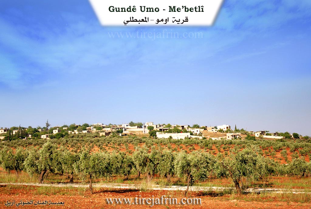
Location and Geography
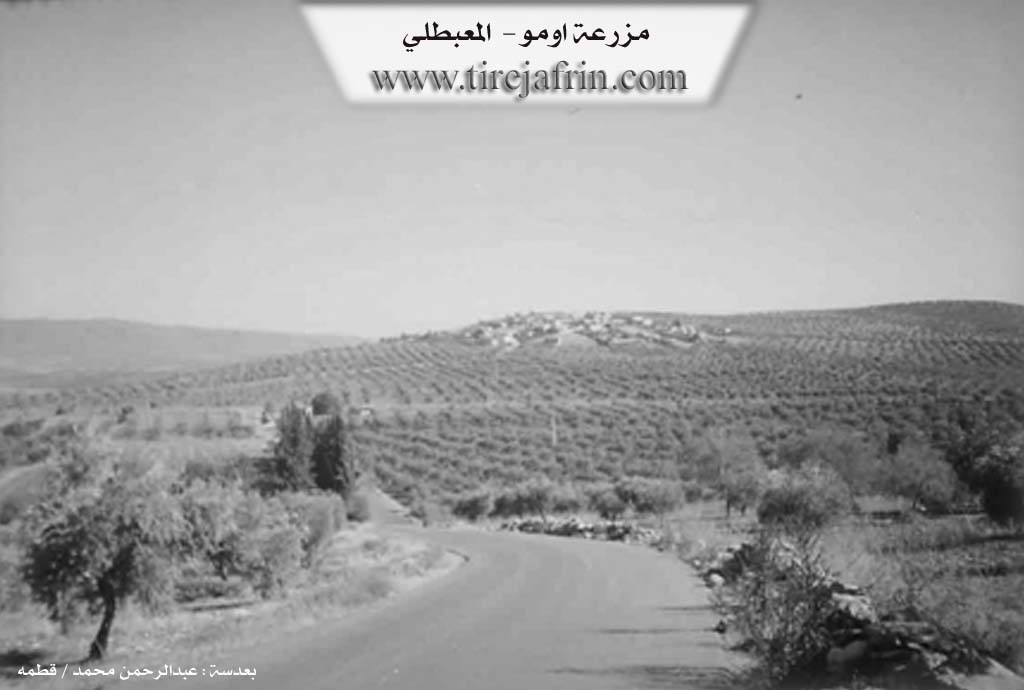
According to the book Efrîn... Her River and Her Green Hills by the writer Ebdulrehman Mihemed from the village of Qetme, Omo is a farm (hamlet) in Çiyayê Kurmênc, administratively belonging to the Mabeta sub-district, Efrîn region, Heleb governorate.
It is a small hamlet located in the central part of the mentioned mountain, atop a limestone plateau that slopes slowly northward toward Geliyê Zerafkê. It is bordered to the north by a slope, Geliyê Zerafkê, the plain of Kitix, and the villages of Anbarlî and Şêx Hûtko. To the south, it is bordered by a slope, a plain planted with olive trees, and the village of Kokan Jêrîn. To the west, it is bordered by a slope, several watercourses, the town of Mabeta, and the farm of Qitranlî. To the east, it is bordered by a slope, a plain planted with olive trees, and the village of Eyn Hecerê Biçûk.
Infrastructure and Statistics
The number of houses in the village is about 30, and its age is approximately 150 years. Its houses are made of stone and cement, expanding westward and northward. An electricity network is available, as well as a water network drawn from the well of Kokan Jêrîn. There is a paved road reaching the center of the village.
Agriculture and Economy
Its inhabitants work in rain-fed agriculture (olives, vines, and walnuts) and irrigated agriculture using artesian wells for summer vegetables and pomegranate trees, alongside raising sheep and goats.
Social Structure
Among its most important families is the Omo family, who were the first to inhabit the village.
Administration
Village Mukhtar: Namî Mihemed Osman.
Sources
Book: جبل الكرد (عفرين) دراسة جغرافية Çiyayê Kurmênc (Efrîn): A Geographical Study by د. محمد عبدو علي Dr. Mihemed Ebdo Elî.
Book: عفرين .... نهرها وروابيها الخضراء Efrîn... Her River and Her Green Hills by عبدالرحمن محمد Ebdulrehman Mihemed from the village of Qetme.
Preparation and execution:
Manager of Tirej Efrîn site: Ebdulrehman Hacî Osman
20/12/2013
II. Summary of Omo from Afrin 366
Source: https://www.youtube.com/watch?v=qRYX82Tcr3I
The documentary focuses on Gundê Emo, a village situated in the Efrîn region, specifically highlighting its rugged geography and historical depth. The host and the guests, including the elder Abû Semîr, explore the village's ancient roots, which are visible in the surviving stone structures and natural formations. According to the host, the village contains ruins and caves that date back approximately 350 to 500 years. One specific landmark, referred to simply as Kevro (The Stone), is a massive stone structure estimated to be 350–400 years old. In the past, the villagers used this site to thresh wheat (genim dikutan), indicating its central role in the agricultural life of the community.
The geography of Gundê Emo is defined by dramatic cliffs and caves. A prominent natural landmark is Zinarê Înê, a cliff or rock formation located below the village proper. The area is dotted with numerous caves (şikat), which the host notes were inhabited by people centuries ago. One specific cave is identified as Qulê Henîfe. During a difficult climb into one of the high caves, the host discovers a stone basin (jirn) and various graffiti left by visitors. Written on the cave walls are names such as Reşo, Xoşnav, Mirdne, and Ehmed, with one date explicitly visible: 1999.
The documentary also sheds light on the region's historical connectivity. At the bottom of the valley, near the water, lies an ancient bridge referred to as Kupriya biniya avê or the iron bridge (cısrê asinî), associated with a location called Ayn Hecerê. The host explains that this area was historically a transit hub where water was once plentiful. An old road known as Reka Êsê passed through here, connecting the region to major cities; people historically traveled this route between Efrîn, Heleb (Aleppo), and Şam (Damascus).
Social history is conveyed through oral storytelling by Abû Semîr. He recounts a legend involving a figure named Şêx Reşîdê Be'dîno and a man named Heyderê Zeynêbê. In the story, Heyderê Zeynêbê challenges Şêx Reşîd regarding a heavy load of firewood. Şêx Reşîd reportedly used 18 stones to braid into his hair (kiziya xwe) to help carry the massive load to his mother, exhibiting great strength. The story also mentions Heyderê Hebeş. These narratives, shared over a breakfast in the fields, illustrate the village's rich oral tradition and the community's deep connection to their ancestors and the landscape.
II. Summary of Omo from Ax û Welat
Source: https://www.youtube.com/watch?v=PHPiwrPIayI
The documentary explores the village of Omo, also historically referred to as Înhacerê or Ên Hecer. Situated in the Afrin region within the Mabeta district, the village is built upon a hill named Çinarê. According to village elders and local historical accounts, the village was established in the mid eighteenth century. Dates of foundation are cited as 1750, 1751, 1752, or 1753. One elder notes that the precise foundation date was even inscribed on the stones of an old house in the village. The settlement takes its name from the Omo family, named after their grandfather Omo, who are recognized as the original founders.
The founding families belonged to the Koçera tribe, specifically the Delikî branch. Following the arrival of the Omo family, several other families migrated to the area to help build and expand the village. The Sîno family arrived from Gulîka. Other notable lineages include the Cûno, Kulîko, Hatino, and Balo, the latter having relatives in the northern regions. The Bazo or Bozo family migrated from Alciya in the Şera district, while the Delo family relocated from Wanê. Additionally, the Silo family and the Hemdî family, who are of Arab descent belonging to the Icêlî tribe, arrived from the village of Sicoyê in the Ezazê region. Today, the village comprises around fifty five to eighty houses, and the families live together with a strong sense of unity.
The landscape surrounding Omo is abundant in water sources and natural landmarks. Villagers rely heavily on local springs, including Kaniya Ziravkê, Kaniya Kokanê, Kaniya Êşê, and Kaniya Bikê. In the past, the flowing waters of Kaniya Ziravkê powered historic watermills, most notably Aşê Hanîm Bûzû, which served several surrounding villages before modern machinery eventually replaced it. The wider geography includes hills and valleys such as Girê Ziravkê, Çiyayê Henan omo, Qiraca Mala Sîno, Geliyê Qurtê, Geliyê Xinzîr, and Geliyê Awra Mistê. Furthermore, the village features distinct geological formations like Kevirê Koxkê and a rocky area known as Zinarê Îniyê. A local elder mentions there are two caves in the rocky terrain, while the narrator specifically names Şikefta Dawe and Şikefta Darmîn.
Historically, the villagers sustained themselves through animal husbandry, particularly herding sheep and producing dairy. Over time, as herds dwindled, the local economy shifted toward agriculture. Residents now cultivate wheat, lentils, chickpeas, and olives to produce oil. In addition to their agricultural pursuits, the village boasts a high education rate and maintains local workshops. Villagers also practice traditional herbal medicine, with elders passing down ancient remedies using local flora for various ailments, a tradition that underscores their deep connection to the environment of Çiyayê Kurmênc. Finally, the village honors its fallen members, with a local square named Meydanoka Şehîd Qehreman dedicated to figures like Şehîd Can Efrîn.
II. Summary of Omo from Afrin 366 2
Source: https://www.youtube.com/watch?v=jvUGirbHr7I
The documentary explores Gundê Omo, a picturesque agricultural village located in the heart of Çiyayê Kurmênc within the Efrîn region. Administratively, the community belongs to the Mabetan district. According to local elder Ebû Nîzar, the village has a history spanning approximately 270 years. It was originally established by a man named Omo, which is how the settlement acquired its primary name. However, during its early years when it consisted of only three or four households, the community was known as Mezrea Sîno. This alternate name honored an early village mukhtar named Mhemedê Sîno and is still used in some official records today.
The social fabric of the village is woven from several interconnected families. The original founding lineage is Mala Omo. Other prominent families include Mala Mihemedî Sîno, Mala Hemdê, Mala Henî Silo, Mala Delo, and Mala Elî Ereb. Through generations of intermarriage, these households have formed a deeply unified community. Currently, the village contains around 60 households. In older times, this unity was displayed during communal activities, such as when the entire village would gather in the main square to boil bulgur wheat together.
The geographical setting of the village is striking, offering sweeping views of neighboring areas like Cindirês, Şorbe Xwînê, and Şora Hawar. The surrounding terrain is rich with historical and natural landmarks. The area features ancient caves, notably Kaf Norin and Kaf Ereb. Another popular local spot is Zinara Îneyê, a well maintained recreational area with water pools and seating where residents and visitors from places like Meydankê gather for picnics. The village graveyard holds generations of ancestors, including notable figures like Hecî Mihemed Alî.
Agriculturally, the village thrives on fertile lands planted with olives, grapes, figs, and historically pomegranates. Due to a lack of modern state infrastructure, the community relies entirely on solar panels for electricity and privately dug wells for water. Previously, a historic shared well near Mefraqa Kûkanê provided water to seven surrounding villages, including Kûkanê Foqanî, Kûkanê Tehtanî, Dargirê, and Cûqê.
Cultural life remains vibrant in the village. The community is home to a traditional Kurdish dengbêj named Emar Îbrahîm, who has been playing the tenbûr since the 1970s. He preserves the musical heritage of the region, singing traditional songs and historical epics about figures such as Mihemed Elî and Hisênê Beto. His music reflects the deep emotional ties the residents have to their ancestral land in Çiyayê Kurmênc and Çiyayê Lêlûn.
II. Ax û Walat Book 2
OMO
22.4.2016
[Image of the village of Omo]
The village of Omo is on a hill named (Zinarê Înê) to the south of the village on the Efrîn-Reco road after the road to Kokanê village. The village of Omo is affiliated with the Mabeta district of the Efrîn canton, located 7 km east of the town of Mabeta and 10 km north of the city of Efrîn.
The name of the village of Omo comes from the Omo family, who are known as the founders of the village and were from the Koçer tribe. After them, the Sîno family came from the village of Gulîka and the village was populated. It is said that the village was founded in 1752.
It is worth mentioning that the village of Omo is also known by the name Ênhecerê.
48
To the north of the village are Henan Omo mountain and Qiracê Mala Sîno where there is a spring named Ziravkê, the Ziravkê hill and the Êş spring, Kevirê Kuxkê,
To the east, the Behîvê ridge, the Kortê valley, the Xenzîr valley, the Dawûd cave, the Darmîn cave, the Xirabe Mill, and the village of Ênhecera Biçûk
To the south, the Efrîn-Reco road and the village of Kokanê, and to the west, the Orê Mistê valley.
The villagers rely on the Ziravkê and Kokanê springs to obtain water.
Around 55 houses and nearly 1000 people live there, of whom 25 families live in the city of Efrîn.
The people of the village, for their livelihood, rely on the cultivation of olives and fields of wheat, lentils, and vineyards. There is a sewing workshop and a printing press in the village, and nearly 15 people work there.
There are 6 families in the village:
The Omo family is the first family to have settled in the village; Sîno came from the village of Gulîka; Dalo, whose relatives are in the Wan region of North Kurdistan; Silo; and the Hemdî family, who are originally Arabs from the Icêl tribe from the village of Sico in the Ezazê region; Bozo came from the village of Alciya in the Şera district.
There is one martyr from the village named Martyr Can Efrîn.
The village's commune is named after Martyr Qehreman
49
There is no school in the village, but the children of the village study at the school in the village of Ênhecera Biçûk. That school was built in 1981 with the help of the 3 villages of Omo, Ênhecera Biçûk, and Ênhecera Mezin.
The elders of the village, Henan Omo, Sîno Kulîlk, Mihemed Sîno, Îbrahîm Rşo who was known by the name ((Deng Beşik)), and Şêxo Sîno.
Cemîl Dalo practices the work of setting broken arms and legs.
The literacy rate in the village is good; nearly 20 people have graduated from university in various fields.
Transcriptions and Subtitles
| Source | Video | Subtitles | Transcript |
|---|---|---|---|
| Afrin 366 1 | Watch Video | Download SRT | View Transcript |
| Afrin 366 2 | Watch Video | Download SRT | View Transcript |
| Ax û Welat 1 | Watch Video | Download SRT | View Transcript |
Foundation/Origin Information of Omo
The Umo family was the first to inhabit the village.
Source: TirejAfrin Site
People once lived in caves in a nearby rock cliff called Zinare Înê.
Source: Afrin 366 Transcript
Possible Village Name Meaning of Omo
Known by three names: Umo, a proper name from Omar. Mala Sini, meaning Sini's house. Goçera, because its inhabitants belong to the Kurdish 'Goçer' tribe.
Source: TirejAfrin Site