General Information
Nahiya (Subdistrict)
Mabeta
Also Known As
Qantarah, Qenterê, قنطرة
Families, Clans, etc.
Hemo Qîbo, Henan, Hesen, Nejar, Qibê

Photos
Basic Information about Qenterê
Source: Afrin 366
Etymology: Derived from the word qenter meaning arch because the ancient stone houses were constructed with vaulted arches
Hills: Hawarê, Cebel Ehlam
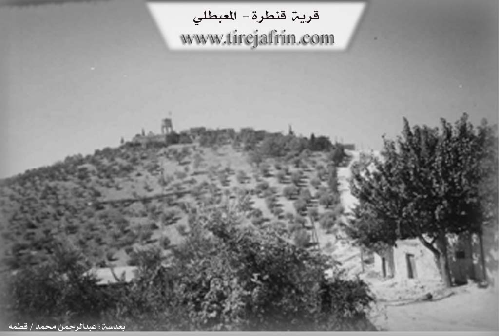
Ruins: Qentera Koko Doro Zenterê, xezana avê
Other Landmarks: Mabatê, Geliyê Cernê, Gundê Welîklî, Gundikê jêr, Gundê Birîmce
Summaries
I. Summary from TirejAfrin Site (English) of Qenterê
Source: https://www.tirejafrin.com/site/kura%20afrin%20%20%20mebetli%20-%20qentere.htm
It is stated in the book جبل الكرد (عفرين) دراسة جغرافية Çiyayê Kurmênc (Efrîn): A Geographical Study by د. محمد عبدو علي Dr. Mihemed Ebdo Elî: Qenter, Qantara /2000 inhabitants - 560m altitude/:
From "Qantara" (arch/bridge) in construction, which is a Kurdish name. The village site is archaeological, and it is said that there were remains of an arch from an ancient archaeological structure at the village site. Abdullah Al-Helou says regarding the word "Qantara" that it is an Arabization from Aramaic and Syriac, and there are those who view its origin as Greek or Latin (p. 53).
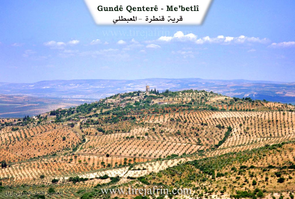
It is a small village located on the summit of a highland that slopes steeply on three sides, except for the eastern side where it connects to the town of Mabeta.
It is stated in the book: عفرين .... نهرها وروابيها الخضراء Efrîn... Her River and Her Green Hills by the writer عبدالرحمن محمد Ebdulrehman Mihemed from the village of Qetme: Qenter: A village in Çiyayê Kurmênc, administratively following the Mabeta sub-district, Efrîn region, Heleb governorate.
It is a medium-sized village located in the central part of the mentioned mountain, atop a high limestone plateau. It is furrowed by watercourses from all its sides to the west of the town of Mabeta at a distance of 500m. Its soil is clayey, and forests and pastures are spread upon it.
It is bordered to the north by a rugged slope, a fertile plain planted with olive trees, the Xeta Trêna Heleb-Meydan Ekbez (Heleb-Meydan Ekbez railway), and the villages of Şêx Kîlo and Heyat.
It is bordered to the south by a harsh slope planted with olive and almond trees, several watercourses, and the village of Mîrkan.
It is bordered to the east by a harsh slope, a deep watercourse planted with olive and almond trees, mountainous highlands, the village of Darkîr Mezin, and the town of Mabeta at a distance of 500m.
It is bordered to the west by a harsh slope, a watercourse, a plain planted with olive trees, the Riya Mabeta-Mîrkan (Mabeta and Mîrkan road), and the village of Ereb Uşaxî at a distance of 2km.
The number of its houses reaches about 75 houses, and its age is approximately 400 years. Its old houses were made of stone and mud with flat wooden roofs; all of these houses are currently extinct, and modern buildings have been built in their place, with modern cement construction spreading around them.
Available in the village are an electricity network, a primary school, a small mosque, and a telephone connected to the Mabeta center. It contains a farmers' cooperative and two modern olive presses. Its people drink from a water network derived from a well southeast of the village, from the waters of the spring of Berbeûş at a distance of 2km north of the village, or from cisterns in which rainwater is collected in winter.
It is connected to the sub-district center by a paved road which passes near it to several neighboring villages. It belongs to the Mabeta municipality. Among its most important families is the Hemo Qîbo family.
The residents work in rain-fed agriculture on an area of 110 hectares (olives, grains, legumes, almonds, apricots). They also cultivate summer vegetables, pomegranate trees, walnut trees, and other fruit trees via irrigation from artesian wells, alongside raising sheep, goats, and cows.
Village Mukhtar: Cemîl Mistefa
Preparation and Execution:
Director of the Tirej Efrîn site: Ebdulrehman Hacî Osman
20/12/2013
Sources:
- Book: جبل الكرد (عفرين) دراسة جغرافية Çiyayê Kurmênc (Efrîn): A Geographical Study by د. محمد عبدو علي Dr. Mihemed Ebdo Elî.
- Book: عفرين .... نهرها وروابيها الخضراء Efrîn... Her River and Her Green Hills by عبدالرحمن محمد Ebdulrehman Mihemed from the village of Qetme.
- Studies of Navenda Tirej Soft / Ebdulrehman Hacî Osman.
II. Summary of Qenterê from Afrin 366
Source: https://www.youtube.com/watch?v=4QdFIsfPhVw
The village of Qenterê is situated in the Mabatê district of the Efrîn region. It is positioned on high ground that overlooks the Hawarê mountain area and Cebel Ehlam. According to a local resident the name of the village is derived from the architectural style of its original buildings. The term Qenterê refers to arches or vaults because the ancient stone houses in the village were constructed with distinctive arched roofs. The village currently consists of approximately 150 households and features a mix of historic architecture and modern amenities like electricity and network water.
The history of Qenterê is physically marked by a central stone arch known as Qentera Koko Doro Zenterê. A resident interviewed near the village water tank states that this structure dates back to the French mandate era. The name of this landmark preserves a specific local oral history concerning a figure named Koko Doro Zenterê who was the father of Zenter. The resident clarifies that while there is a village named Zenterê elsewhere in Efrîn the name in this context refers to a person rather than a place. Another geographical feature mentioned in relation to this area is Geliyê Cernê which is a valley located nearby.
The social landscape of Qenterê includes several specific family lineages and compounds. The host connects with the village through Ferhad Ebdo Henan suggesting the presence of the Henan family. During the tour the host points out specific households such as mala Hesen and directs the camera toward notable compounds like Hewşa Qibê and Hewşa Nejar. The terrain is described as steep and difficult in places with roads winding down toward Gundikê jêr and connecting to neighboring locations like Gundê Welîklî and Gundê Birîmce. The village is also noted for its agriculture particularly walnut trees and the ancient water tank that serves the community.
Transcriptions and Subtitles
| Source | Video | Subtitles | Transcript |
|---|---|---|---|
| Afrin 366 1 | Watch Video | Download SRT | View Transcript |
Foundation/Origin Information of Qenterê
Among its most important families is the Hamo Qibo family.
Source: TirejAfrin Site
Possible Village Name Meaning of Qenterê
From 'al-qantarah' (the bridge/arch) in construction. It is said that there were remains of a bridge for an ancient archaeological building at the village's location. The word is considered an Arabization from Aramaic and Syriac, or of Greek or Latin origin.
Source: TirejAfrin Site