General Information
Nahiya (Subdistrict)
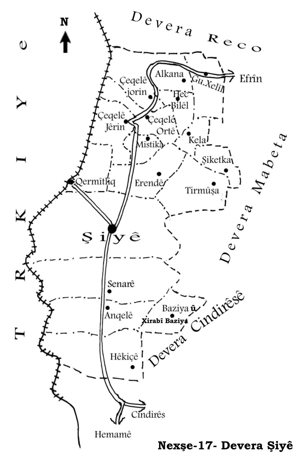
Şiyê
Also Known As
Kermêtliq, Qara Matlaq, Qermilqê, Qermitlîq, Qermtalqê, Qermîliq, Qermîltiq, Qermîltiqê, Qermîtiq, Qermîtlaq, Qermîtlaqê, Qermîtliq, Qermîtlêq, al-Khazfiya, الخزفية (al-Khazfiyah), قرمتلق, قره متلق
Families, Clans, etc.
Beklero, Dawûd, Derwîş, Hac Îbrahîm, Mala Beklerê, Mala Bilko, Mala Dewrîş, Mala Ebdilla, Mala Huseynî Têwê, Mala Îbrahîm Yûsiv, Mala Şêx Silêmên, Mala Şêxê
Photos
Basic Information about Qermîtliq
Source: Ax û Welat
Etymology: Derived from qermît meaning tiles as the area was historically a site for tile manufacturing
Foundation Date/Period: Approximately 500 years ago
Springs: Kilsê
Hills: Gedûka Helebê
Shrines: Mala Şêx Silêmên, Dara Miraza
Ruins: Xan
Trees: Dara Miraza
Other Landmarks: Toros, Amanos
Summaries
I. Summary from TirejAfrin Site (English) of Qermîtliq
Source: https://www.tirejafrin.com/site/kura%20afrin%20%20%20shiye%20-%20qermitliq.htm
It is stated in the book جبل الكرد (عفرين) دراسة جغرافية Çiyayê Kurmênc (Efrîn): A Geographical Study by د. محمد عبدو علي Dr. Mihemed Ebdo Elî:
Qermitliq, Arabized as Xezfiyê / 2718 inhabitants, 3km, 230m /:
"Qermît" means ceramics or pottery in Kurdish. The Arabized name is a translation of its Kurdish name.
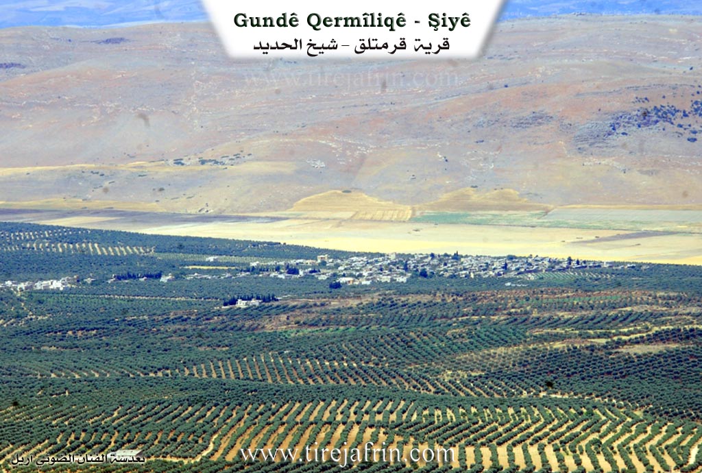
It is a large village located west of the town of Şiyê, adjacent to the Turkish border, surrounded by barbed wire from the west. The first Kurdish folk arts group was founded here in the 1960s. Next to it was a camp for Ibrahim Pasha, son of Muhammad Ali Pasha, during his campaigns against Syria in the nineteenth century.
It is stated in the book عفرين .... نهرها وروابيها الخضراء Efrîn... Her River and Her Green Hills by the writer عبدالرحمن محمد Ebdulrehman Mihemed from the village of Qetme:
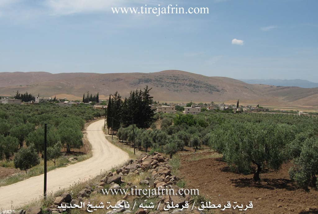
Qermitliq: A village in Çiyayê Kurmênc, administratively belonging to the Şiyê district of the Efrîn area, Heleb governorate. It is a large village situated at the end of the western slope of the middle part of the mentioned mountain, in a fertile plain with volcanic soil. Its lands slope gently toward the west until they border the edges of the Sanjak of Îskenderûn. It is 7km northwest of Şiyê.
It is bordered to the north by a fertile plain planted with olive trees and the village of Şêx Çeqelî; to the south by the plain of the Sanjak of Îskenderûn and the Turkish border; to the east by a fertile plain planted with olive trees and the town of Şiyê; and to the west directly by the border strip and the Amûq plain.
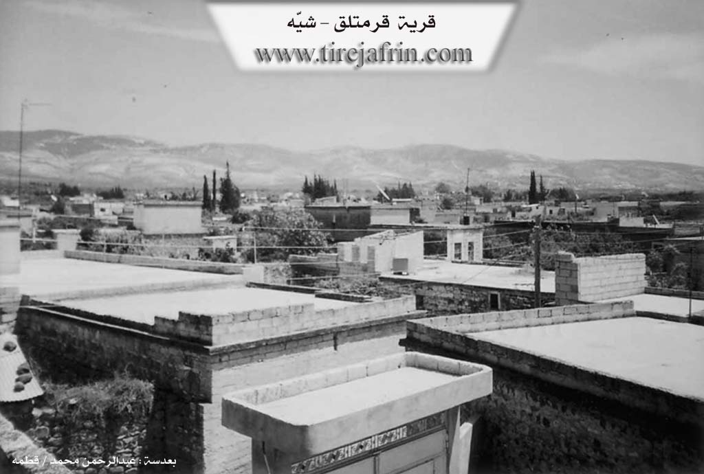
The number of its houses is about 150, and its age is 400 years. Its old dwellings are made of stone and mud with flat wooden roofs, while the modern ones are concrete, except for the southern ones adjacent to Turkish territory. The settlement of the area is ancient, evidenced by the presence of remaining traces of decorated pottery and cisterns built from basalt and limestone rocks. Its roofs are in the form of arches, and there are basalt columns with capitals.
The village has an electricity network, telephone service, a primary and middle school, and a mosque in its center. The residents work in the cultivation of rain-fed olives, grains, and legumes, as well as irrigated crops from artesian wells, including vegetables, pomegranates, apricots, almonds, and lemons, alongside livestock farming. The people drink water from cisterns and tanks filled with rainwater.
It is an ancient village dating back to the Ottoman era. The border strip passes on the western side at a distance of 500m. It is connected to the district center by an asphalt road.
Among the families in the village of Qermitliq are: Hac Îbrahîm (specifically Qertel, one of the founders of the Qermitliq folk heritage group), Beklero, Derwîş (specifically Mehmûd Derwîş, one of the founders of the Qermitliq folk heritage group), and Dawûd (Henîf Kurdî), in addition to many holders of university degrees and institute diplomas.
Village Mukhtar: Zekerya Hacî Îbrahîm
Preparation and Execution:
Manager of the Tirej Efrîn website: Ebdulrehman Hacî Osman
20/12/2013
Sources
Book: جبل الكرد (عفرين) دراسة جغرافية Çiyayê Kurmênc (Efrîn): A Geographical Study by د. محمد عبدو علي Dr. Mihemed Ebdo Elî.
Book: عفرين .... نهرها وروابيها الخضراء Efrîn... Her River and Her Green Hills by عبدالرحمن محمد Ebdulrehman Mihemed from the village of Qetme.
Studies of Navenda Tirej Soft / Ebdulrehman Hacî Osman.
II. Summary of Qermîtliq from Ax û Welat
Source: https://www.youtube.com/watch?v=uBeELpdDr44
The village of Qermilq, also referred to as Qermîliq or Qermîx, is situated in the Şiyê district of Çiyayê Kurmênc, approximately 44 kilometers northwest of Efrîn. Nestled near the Amanos and Toros mountains, the village shares a border with the region north of the line drawn in 1938. The name Qermilq is derived from qermît, meaning tiles, as the location was historically a center for manufacturing tiles and bricks from the local soil. Before the current village was established around 500 years ago, the site served as a Xan (caravanserai) on the trade route known as Tarîq el Herîr (Silk Road) or the camel route, where caravans traveling between Heleb and Stenbol would rest. A nearby pass is known as Gedûka Helebê or Bawabet Heleb.
The village population consists of roughly 300 households. The original settlers were shepherds described as Mala Şêxê. The community is historically anchored by four foundational families: Mala Ebdilla, Mala Îbrahîm Yûsiv, Mala Beklerê, and Mala Dewrîş (also known as Mala Sîsya). Over time, other families such as Mala Bilko and Mala Huseynî Têwê established themselves there. The villagers follow the Rifaî order, gathering for dhikr on Friday evenings at Mala Şêx Silêmên. A significant religious figure, Îbramê Şêxo, began constructing the village mosque in 1344 Hijri (approximately 1925) but passed away before its completion; his tomb bears the Turkish inscription "Gelen û gêten" (Those who come and those who go).
A defining feature of Qermilq is its water source, Kilsê, located three kilometers east near Şiyê. A local legend dictates that the spring flows for seven years and runs dry for seven years, a cycle mythologically controlled by a girl or a young man sitting upon the source. The village is also famous for a 500 year old wishing tree called Dara Miraza. Visitors from surrounding villages like Erendê and Çaqela come to the tree, particularly on Wednesdays, to tie fabrics and sacrifice black chickens in hopes of curing illnesses or granting wishes.
The modern history of Qermilq is marked by the hardening of the border. While a border existed since 1938, villagers could access their lands until 1967. After the total closure, the village lost approximately 1200 hectares of farmland to the Turkish side. Despite these hardships, the village maintained a vibrant culture, establishing a noted folklore dance group in 1958 led by Menan Axê, which was known as Firqet el Funûn el Şeibiye li Cebel el Ekrad. The village is also known for a specialized ceremonial dish called Kutik, made with wheat, chickpeas, and chicken, traditionally prepared for weddings and funerals. Additionally, traditional healing practices persist, with elders like Apê Mihemed performing procedures to cure tongue tied children.
Transcriptions and Subtitles
| Source | Video | Subtitles | Transcript |
|---|---|---|---|
| Ax û Welat 1 | Watch Video | Download SRT | View Transcript |
Foundation/Origin Information of Qermîtliq
Among the families are Haj Ibrahim (Qartal) and Mahmoud Darwish, who were founders of the Qarmatlaq folk heritage troupe.
Source: TirejAfrin Site
Originally established as a khan for caravans on the Silk Road. The village was founded by four or five families who migrated from Zorava for sheep grazing, settling near the ruins of the old khan.
Source: Ax û Walat Transcript
Possible Village Name Meaning of Qermîtliq
'Qarmit' means pottery in Kurdish. The Arabic name is a translation.
Source: TirejAfrin Site
Its name is derived from the Kurdish word for bricks/tiles ('qermîd'), as it was a production center for these materials.
Source: Ax û Walat Transcript