General Information
Nahiya (Subdistrict)
Mabeta
Also Known As
Al-Ma'zulah, Morotê, Mûruta, Mûrûtî, Rutanli, Rûta, المعزولة, روتا, روطانلي, روملو
Tribes
Milan, Xastiyan
Families, Clans, etc.
Heswalîka, Hisên Hebeş, Hungo, Usemê, Çûçê, Şêx Bilêl

Photos
Basic Information about Rûta
Source: Ax û Welat
Etymology: Derived from the Kurdish word 'rût' (naked/bare), as the area was originally a mountain devoid of trees.
Springs: Kaniya Rûta
Hills: Çiyayê Xastiyan
Shrines: Ziyaretgeha Extiyêr
Ruins: Qap, Şebeqa
Other Landmarks: Geliye Dûdê, Geliye Circim, Geliye Cehenemê, Geliye Dolê, Daristana Evdê, Zorê
Summaries
I. Summary from TirejAfrin Site (English) of Rûta
Source: https://www.tirejafrin.com/site/kura%20afrin%20%20%20mebetli%20-rutenle.htm
It is stated in the book جبل الكرد (عفرين) دراسة جغرافية Çiyayê Kurmênc (Efrîn): A Geographical Study by د. محمد عبدو علي Dr. Mihemed Ebdo Elî: Rûta, Rûtanlî, Al-Ma'zûlah / 755 people 290 hectares 15km 580m.
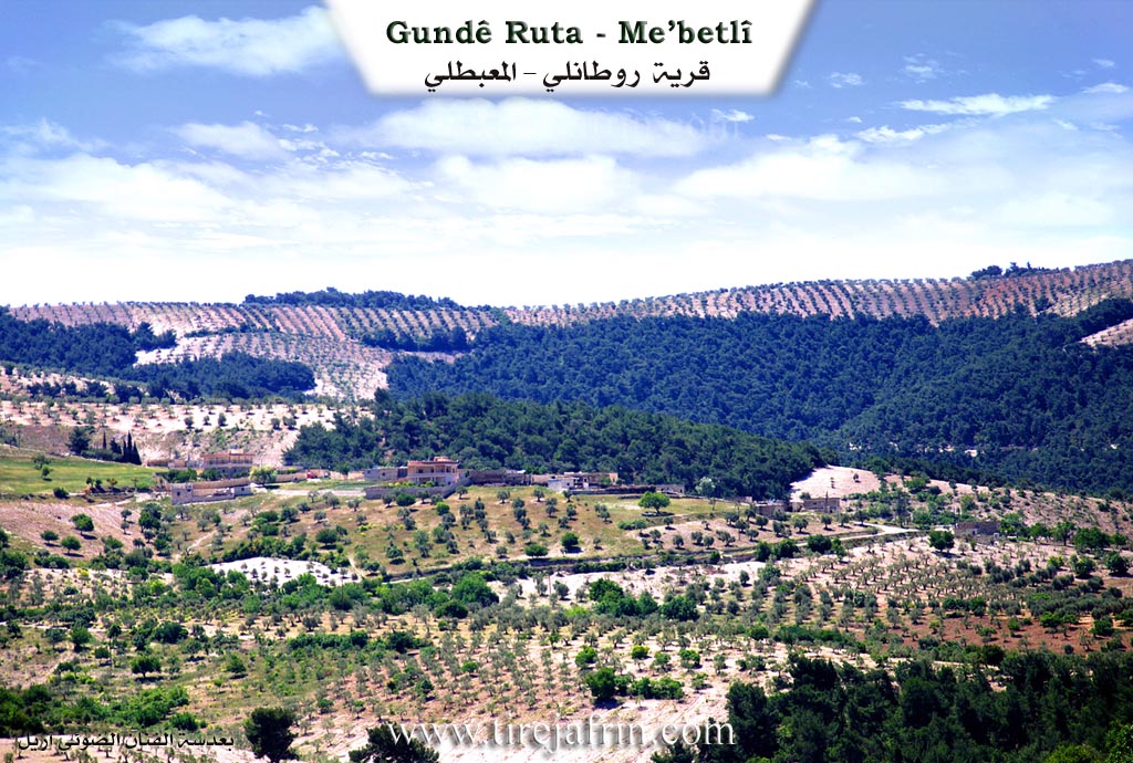
Rûta: Meaning "the naked ones or the isolated ones" in Kurdish. There is a Kurdish tribe with the same name, whose homeland is in Northern Kurdistan in the Meletî region. It is a small village belonging to the villages of Xastiyan, located on the northwestern slope of a limestone plateau. Pine forests and olive fields are spread around it.
It is stated in the book عفرين .... نهرها وروابيها الخضراء Efrîn... Her River and Her Green Hills by the writer عبدالرحمن محمد Ebdulrehman Mihemed from the village of Qetme: Rûtanlî is a village in Çiyayê Kurmênc, affiliated with the Mabeta subdistrict, Efrîn region, Aleppo governorate.
It is a small village located in the middle section of the mentioned mountain, on the northwestern slope of a limestone plateau and at the beginning of a torrential valley that slopes towards the west. It is 15km away from the town of Mabeta towards the southwest. Its soil is clay, covered with pastures and forests.
It is bordered to the north by a harsh, steep slope, Geliyê Cercim (Cercim valley), and the village of Hac Qasim on the highest mountain peak. To the south, it is bordered by a deep torrential valley, a high and rugged mountain chain of forest trees, the village of Kurdan, and the village of Xalta Rojava. To the west, it is bordered by a steep slope, the fertile Geliyê Cercim (Cercim valley) planted with walnut, apricot, and olive trees, and the village of Dalyan. To the east, it is bordered by mountain heights, a torrential valley planted with olive trees and forestry, and the village of Îkî Axûr.
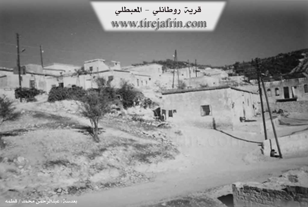
Its residences are stone and mud with flat wooden roofs, and it contains modern concrete residences. A electricity network, a primary school, an olive press, and an agricultural cooperative society are available in the village. Its people drink from a spring east of the village at a distance of 2km, or from cisterns in which rainwater collects in winter.
Its residents rely on rain fed agriculture on an area of 290 hectares with grains and olive trees, and irrigated agriculture from artesian wells in the north of the village in Geliyê Cercim (Cercim valley) for summer vegetables and fruit trees (apricots, pomegranates, and walnuts), alongside raising sheep and goats. A paved road connects it to the subdistrict center, reaching the middle of the village.
Village Mukhtar: Zahid Ixtiyar
Preparation and Execution:
Manager of Tirej Efrîn site: Ebdulrehman Hacî Osman
20/12/2013
Sources:
- Book: جبل الكرد (عفرين) دراسة جغرافية Çiyayê Kurmênc (Efrîn): A Geographical Study by د. محمد عبدو علي Dr. Mihemed Ebdo Elî.
- Book: عفرين .... نهرها وروابيها الخضراء Efrîn... Her River and Her Green Hills by عبدالرحمن محمد Ebdulrehman Mihemed from the village of Qetme.
- Studies of Navenda Tirej Soft / Ebdulrehman Hacî Osman.
II. Summary of Rûta from Ax û Welat
Source: https://www.youtube.com/watch?v=zK4bHFG2wJQ
The village of Rûta is located in the Mabatayê district of the Efrîn region, nestled within the Xastiyan mountains. Its name is derived from the Kurdish word for "naked" or "bare," referring to the time of its founding when the mountainside was devoid of vegetation. While the village appears ancient, evidenced by numerous caves and cisterns, its modern settlement began with the arrival of the Heswalîka family, who belonged to the Milan tribe. They built the initial compound, and were subsequently joined by other families including Hisên Hebeş, Şêx Bilêl, Hungo, Çûçê, and Usemê, transforming the settlement into a thriving community that eventually comprised around 60 households.
Geographically, Rûta is surrounded by significant natural landmarks. To the north lie the villages of Hec Qasima and Mişt Aşûra, and the valley of Geliye Dolê. To the south lies Geliye Cehenemê (The Valley of Hell), a dense forest area filled with diverse trees like strawberry trees and junipers. The local valley is known as Geliye Dûdê, which flows down into the area known as Geliye Circim. To the east lies the forest of Daristana Evdê (also called Zorê) and a historic water source known as Kaniya Rûta. This spring historically served shepherds and travelers and is now used for irrigation. The village also contains ancient ruins, including old houses known as Qap and a historic wall called Şebeqa on the eastern side. A sacred site, Ziyaretgeha Extiyêr, is located to the north and remains a place where locals go to make wishes.
Historically, the economy of Rûta relied heavily on charcoal production (komer). Elders recall that before the borders were drawn and barbed wire was installed, villagers would transport charcoal by pack animal to markets in Heleb and Hemamê. Later, the agricultural focus shifted to vineyards, olives, and grain trade with the Cûmê plain. In modern times, the village has developed local industry, including a textile workshop and a water bottling plant named Destgeha Rûta, initiated by the local commune named after the martyr Şehîd Kemal.
A distinct cultural feature of Rûta is a "secret" language spoken primarily by the women, known as "zimanê çivîka" (bird language) or "zimanê rût." This coded speech involves inserting the letter "z" into syllables to disguise conversations from outsiders or men. While the practice is fading among the youth due to modern technology, the older women still recall how to speak it fluently. The village has also been home to traditional craftsmen, such as the saddle-maker Mihemed, son of Omer, whose family originally came from Bela and whose craft is now on the verge of disappearing. Notable figures in the village's history include the elder Hec Şukrî and the engineer Hec Ehmed, who contributed significantly to the village's infrastructure.
II. Ax û Walat Book 2
RÛTA
23.6.2016
[Image of the village of Rûta]
The village of Rûta is affiliated with the Mabeta district of the Efrîn canton, located 17 km west of the town of Mabeta and 30 km northwest of the city of Efrîn.
Rûta is the last village of the Mabeta district and one of the villages of the Xastiyan mountain region.
The name of the village comes from a Kurdish word, which means ((Bare)), because, as it is said, the village was without trees, or bare.
Heswelîk was the first person to settle in the village; he is from the Milan tribe. It is said that a tribe named RÛTA lives in the Serê Kaniyê area, but there is no information regarding the connection of the village's people to this tribe.
51
The village of Rûta appears to be an ancient village, and the abundance of caves and cisterns are guides to this truth.
There are nearly 60 houses in the village, and the total number of inhabitants is around 600, but some families reside in the cities of Efrîn and Cindirêsê.
8 families live in the village of Rûta:
The families of Heswelîkê, Hisê Hebeş, Extiyêr, Hingo, Os Umê, Şêx Bilêl, Hisê, and the Kurtancî family.
To the north of the village are the two villages of Hecqasma and Misteşûra and the Dolê valley; to the east lie the village of Kaxrê and the Rûta spring. The water of this spring never dries up; it was a resting place for shepherds and travelers, and at the same time, the people of the surrounding villages would wash their clothes there. Now, farmers water their gardens and fields from it.
To the south is the Cehnimê valley, which is adorned with a dense forest of arbutus, hawthorn, oak, and terebinth trees.
And to the west, the EVDÊ or ZORÊ forest; which is a terebinth forest where many animals live, from foxes, wolves, rabbits, wild boars, snakes, and birds like blackbirds, partridges, turtledoves, bee-eaters, ...live.
The Extiyêr shrine is to the north of the village; to this day, the people of the village visit it on occasions to fulfill wishes and desires.
52
There are many water cisterns around the village, dug by the benefactors of the village for travelers, shepherds, and farmers.
Many ancient houses, like shells, were built in the village long ago.
There is an ancient area to the east of the village named ((Şebeqa)), in which there are ancient cisterns and caves as witnesses to the antiquity of the area.
The people of the village make their living from agriculture, from olives, sumac, walnuts, apricots, vineyards, and some people also raise livestock.
There is a sewing workshop in the village where 10 people work, and also a water bottling plant named ((Rûta Plant)) has been built in the village, and more than 12 people work there.
More than 5 people also work in the institutions and bodies of the Autonomous Administration. Some people from the village also engage in trade.
There are 4 martyrs from the village who gave their lives within the Kurdistan Freedom Movement at various times:
Martyr Kemal, Martyr Dilşêr, Martyr Nîdal, and Martyr Sebrî.
The village's commune is named after Martyr Kemal, and the school is named after Martyr Dilşêr.
Hec Şukrî was an elder of the village and had a prominent role among the people of the village.
53
It is worth mentioning that olive oil merchants primarily came from the village of Rûta, such as: Hesenê Ehmed, Xocê Reşik, Hisênê Evdikê, and Silêmanê Hemûşê.
Hec Ehmed, an agricultural engineer, held a high position in Aleppo; he provided many services to the village, from repairing and building the roads around the village, providing drinking water, and did many other things correctly for his people.
Rêber Armanc is a famous artist. He was an old member of the Armanc folklore group; he created many love and national songs.
There is a mosque and an olive press in the village.
[Image of Rêber Armanc]
Transcriptions and Subtitles
| Source | Video | Subtitles | Transcript |
|---|---|---|---|
| Ax û Welat 1 | Watch Video | Download SRT | View Transcript |