General Information
Nahiya (Subdistrict)
Mabeta
Also Known As
Al-Safraa, Sari Oshaghi, Sariya, Soriya, الصفراء, صاري أوشاغي, صاري اوشاغي
Tribes
Şêxiyan
Families, Clans, etc.
Bekir Xûce, Cewher, Hacî, Haskerzê, Hecî, Heskelekê, Hesko, Kûze, Minanî Heso, Osman Elek, Seyid Xaje, Çîlo, Çûyê Xozyana

Photos
Basic Information about Sariya
Source: Ax û Welat (Information for Sariya and Şêtana)
Etymology: Named after the founder Mihme Soru (or Soro), meaning 'Red' or 'Blond' due to his complexion; later Turkified to Sorya
Foundation Date/Period: Approximately 400 to 450 years ago
Springs: Kaniya Sêvê
Hills: Çiyayê Açolo, Çiyayê Qîbê
Shrines: Ziyaretgeha Sariya
Ruins: Ma'ser
Wells: Bîra Xoziana, Bîra Qerşîlê, Bîra Xurşînê
Other Landmarks: Gola Sariya
Summaries
I. Summary from TirejAfrin Site (English) of Sariya
Source: https://www.tirejafrin.com/site/kura%20afrin%20%20%20mebetli%20-%20sariya.htm
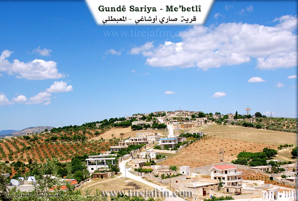
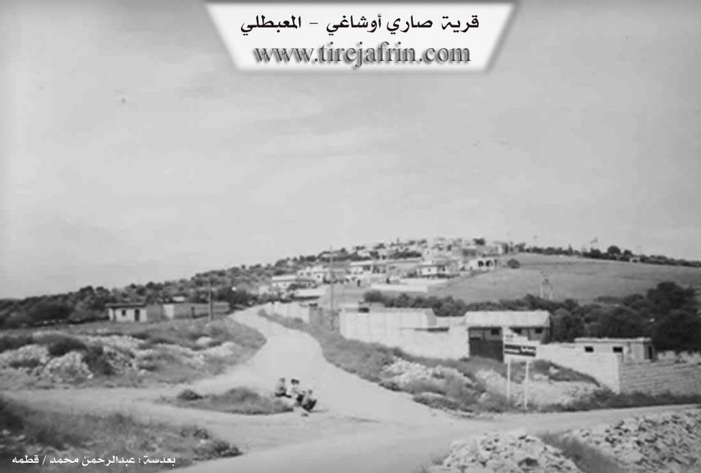
The following is stated in the book جبل الكرد (عفرين) دراسة جغرافية Çiyayê Kurmênc (Efrîn): A Geographical Study by د. محمد عبدو علي Dr. Mihemed Ebdo Elî: Sariya, Sari Uşaxî, Safra. The village statistics are: 1166 inhabitants, 500 hectares of land, 13 kilometers from the center, and 700 meters in elevation.
Sariya: The name is of Turkish origin from the word "Sari," meaning "the blond" or "the yellow." It was a nickname for the first resident of the village, who was a blond man with red skin. The Arabized name is a translation of the Turkish name. It is a small village located atop the summit of Çiyayê Hemo. It is adjacent to the village of Rehmaniyê.
The following is stated in the book عفرين .... نهرها وروابيها الخضراء Efrîn... Her River and Her Green Hills by the writer عبدالرحمن محمد Ebdulrehman Mihemed from the village of Qetme: Sari Uşaxî is a village in Çiyayê Kurmênc, administratively belonging to the Mabeta district, Efrîn region, Heleb governorate. It is a small village located in the central part of the mentioned mountain, atop the summit of Çiyayê Hemo, which slopes steeply in its northwest towards Geliyê Rîşa. It is 13 kilometers away from the town of Mabeta towards the northwest. Its soil is clay like.
The village is bordered to the north by a steep slope, Geliyê Sîlê, mountainous highlands, and the village of Qudê Koy at the highest mountain peak to the north. To the south, it is bordered by the nearby village of Rehmaniyê at a distance of 500 meters. To the west, it is bordered by the village of Hemilka at a distance of 1 kilometer in the western direction. To the east, there is a slope and the village of Kurka Jorîn. The number of its houses is about 45 houses, and its age is about 350 years. Its dwellings are made of stone and mud with flat wooden roofs, while modern concrete dwellings are spreading around it and extending towards the west.
The village has an electricity network and a water network connected to the Rehmaniyê well in the bottom of the valley. It contains a primary school and a small mosque. A paved road connects it to the district center, passing through the middle of the village to several neighboring villages. Its residents work in rain fed agriculture on an area of 500 hectares, cultivating grains, legumes, and olives. They also practice irrigated agriculture from artesian wells in the southern plain of the village of Rehmaniyê, growing summer vegetables and fruit trees, alongside raising sheep and goats. Among its most important families is the family of Osman Elek, who were the first to inhabit the village. There are several villas on the western side of the village on the public road.
Village Mukhtar: Ehmed Hebeş Bilal
Preparation and Execution:
Director of the Tirej Efrîn website: Ebdulrehman Hacî Osman
20/12/2013
Sources:
- Book: جبل الكرد (عفرين) دراسة جغرافية Çiyayê Kurmênc (Efrîn): A Geographical Study by د. محمد عبدو علي Dr. Mihemed Ebdo Elî.
- Book: عفرين .... نهرها وروابيها الخضراء Efrîn... Her River and Her Green Hills by عبدالرحمن محمد Ebdulrehman Mihemed from the village of Qetme.
- Ebdulrehman Hacî Osman, Director of Tirej Efrîn.
II. Summary of Sariya and Şêtana from Ax û Welat
Source: https://www.youtube.com/watch?v=oWc7vZetDuk
The village of Sorya, also known as Sariya, is located in the Mabata district of the Efrîn region. Situated at the foot of Çiyayê Açolo within the Çiyayê Qîbê mountains, the village has a history spanning approximately 400 to 450 years. The name originates from its founder Mihme Soru (or simply Soro), whose nickname "Sor" referred to his red or fair complexion. Locals explain that during the Ottoman era the name was adapted to Sorya or Sariya, which bears a resemblance to the Turkish word for "yellow" or "blond." In later periods, the Baathist regime attempted to rename the village Saruşağı or Safra, but the original name persisted among the residents.
The community is historically rooted in the Şêxiyan tribe. Oral history recounts that Soro and his brother Ala were the initial figures, with Soro settling in the village while Ala established himself in Mabeta. The village social structure was originally built around four primary families: Heskelekê, Hecî, Çîlo, and Haskerzê. Over time, other families such as Seyid Xaje, Kûze, and Cewher immigrated from nearby locations like Şêx Bil and Senarê. Conversely, some lineages such as Bekir Xûce and Minanî Heso migrated away to villages like Çaqala and Xozyana. A particularly notable figure in village history was Êma Osê, a woman from the Heskelekê family who served as the village mukhtar around 1850, taking over the role from her father Osê Soro. In the 20th century, residents such as Elî Çîlo, Ahmedê Heskûlek, and Şêx Henîf were known for participating in uprisings against the French occupation.
The landscape around Sorya features several significant water sources that supported its agricultural life, primarily olive cultivation. These include the spring Kaniya Sêvê and wells such as Bîra Xoziana, Bîra Qerşîlê, and Bîra Xurşînê. A communal pond known as Gola Sariya traditionally provided water for livestock and served as a shared point between Sorya and the neighboring villages of Hebû and Şêytana. The village preserves the ruins of traditional olive presses known as Ma'ser, with one historic press located beneath the Heskelekê house dating back over a century.
Spiritual life in Sorya includes the veneration of a site called Ziyaretgeha Sariya, which locals visit on Wednesday mornings. The village also maintains a unique healing tradition associated with a specific house where lightning once struck a sheepfold, killing the entire flock. This location is now considered a place of healing called orî. Shepherds from surrounding areas bring sick livestock to this site on Wednesdays, believing the visit provides a cure for their animals. The cultural heritage of the area is further documented by local artists and poets like Bavê Ceng, who capture the history of the region and landmarks like Kelê Hûrî in their work.
II. Summary of Sariya from Khalil Sino
Source: https://www.youtube.com/watch?v=XXfkAJMg_j8
The documentary explores the historical and social landscape of Sariya, a village situated in the elevated areas of the Mabatê district within the Efrîn region. The host tours the village, which features many ancient stone houses, some of which stand in ruin due to the prolonged conflict in the area.
During a conversation with the village mukhtar, Beşîr Hemîd Mihemed, who belongs to the Hesko family lineage, the deep history of Sariya is revealed. According to oral tradition passed down from the elders, the village was established approximately four hundred years ago. The ancestors originally migrated from Tirkiyê to settle in this local Sûrî area. The foundation of the community is attributed to three brothers who established the three primary families of the village, namely the Hesko, Hacî, and Çîlo families. While the village once boasted around one hundred households, the current population has decreased to between sixty and seventy homes.
At the spiritual heart of the village stands a sacred olive tree known as Ziyaretê. The mukhtar explains that this tree is roughly four hundred years old, dating back to the founding of the village. It serves as a shrine dedicated to a local saint and martyr named Şêx Mihemed. The site is highly revered because many villagers have reported seeing the martyr in their dreams standing by the tree. Out of deep respect and religious awe, the residents strictly forbid anyone from damaging or cutting branches from this sacred tree.
Daily life in Sariya presents several challenges regarding infrastructure. The village does not have a medical clinic, a pharmacy, or even a basic grocery store. For these necessities, residents must travel to the city of Efrîn, located twenty four kilometers away. However, recent improvements have been made to their water supply. The community relies on a local well named Sariya and a water network connected to the Kaniya Reş spring, which was facilitated by the Behar organization. Historically, the local economy has depended heavily on olive cultivation. Before modern local presses were available, villagers would transport their olive harvests to presses in neighboring areas such as Erebê, Şêx Hesen, and Dêr Mîlyo.
The documentary also captures the social fabric of the village through interactions with local women. The host speaks with Xedîce, who notes that many young people have left for places like Heleb due to a lack of employment. Another resident, the mother of Mistefa, shares that she originally hails from the nearby village of Darwîş but married into Sariya. As the visit concludes, the mukhtar sends a heartfelt message to the Kurdish diaspora, urging them to unite and send aid to rebuild their ancestral villages after years of hardship. The journey ends acknowledging the beautiful surrounding villages such as Xelîl, Hebo, Şeytanê, Alkano, Me'melê, Emer, Dikirko, Cemaliko, Qentere, Xozayana Jêr, and Xozayana Jor.
II. Ax û Walat Book 2
61
SARIYA
13.1.2017
The village of Sariya was built on a high mountain named Eçolo mountain. It is affiliated with the Mabeta district of the Efrînê canton, 8 km north of the town of Mabeta and 27 km northwest of the city of Efrînê.
The name of the village comes from the word (SORO). It is also the nickname of the first person to settle in the village, because he was a grey-haired person, this name was given to him. Also, (Sarî) in Turkish means grey. It is worth mentioning that there is a village with the same name near Melatiyê called (Sarî Mehele). As the villagers state, there is a social connection between the two villages.
The first person to settle in the village was Soro, and later his son Osman, or Oso, populated the village, and he is from the Şêxî tribe.
62
is. After them, other families came and the village was populated. It is worth remembering that Soro and Ala are brothers. Ala settled in Mabeta and Soro in Sariya.
To the east of the village are the KITIX plain and the village of Kurka Jorîn. To the south is the village of Şeytana, which has become one with the village of Sariya, and the Xazyana plain. To the west are the villages of Hebo and Xelîl, and to the north are the villages of Kurka Jêrîn and Dimiliya.
The Qurşînê Well is to the west of the village. Its water remains in all seasons; it used to be the main source of water, but now it is not used, only shepherds sometimes water their flocks from it.
The Sariya Lake is between 3 villages: Sariya, Hebo, and the village of Şeytana. Water would collect in it and remain until the end of summer; the villagers would water their flocks from it.
The Sariya shrine is to the east, near the village. To this day, the people of the village visit it on Wednesday mornings.
There are 2 ancient olive presses in the village. They operated in a classical way since the French era and now only remain as statues.
The people of the village make their living from agriculture, and like all the surrounding villages, olives are the main product, along with walnuts, apples, pomegranates, and almond trees. Some families also own livestock such as cows, sheep, and goats.
Nearly 12 people go daily to the city of Efrînê to work in various factories, and around 20 people in institutions and
63
bodies of the Autonomous Administration work in the town of Bedîna and in the city of Efrînê.
Nearly 80 houses and around 1000 people live in the village. Nearly 40 families also live in Efrînê.
There are 2 martyrs from the village:
Şehîd Avreş and şehîd Xwîndar.
The village commune is named after Ş. Avreş and the village school is named after Ş. Dilşêr.
It is worth mentioning that the village school is old, built in 1952, and students from 7 surrounding villages studied there. Therefore, the literacy rate in the village is high, and many people have graduated from university as doctors, engineers, lawyers, teachers, and from various other departments.
Hec Fîlik, as the village mukhtar, provided many services and work for the village.
Hec Xelîl Hec Hesen, as a rebel with the family of Ehmedê Xelîl from Me’mila and Erifê Hemîd, carried out many activities against the French, and as a result, the French burned their homes.
There are 10 families in the village:
The family of Hes Kulek, Hec Hesen, Çîlo, Hes Kirzê, Seyîd Xeco, Kîzê, Menanê Heso who settled in the village of Xazyana Jorîn, Bekirê Xoce who now in the village of Çeqela Jorîn
64
live, and of the two families of Nibê and Simo, no one remains.
Nîhad Ce’fer is a lawyer and one of the founders of the Kurdish Democratic Party, and because of that, he faced much torture and detention.
Elê Çîlo, Ehmedê Hes Kulek, Hesenê Hes Kulek, Şêx Henîf, and Reşîdê Hec Qadir joined the uprisings against the French occupation.
It is worth mentioning that in the 1850s, a woman named ((Êma Osê)) was the mukhtar of the village of Sariya; she was the sister of Hes Kulek and was elected in place of her father, Osê Soro.
Transcriptions and Subtitles
| Source | Video | Subtitles | Transcript |
|---|---|---|---|
| Khalil Sino 1 | Watch Video | Download SRT | View Transcript |
| Ax û Welat 1 | Watch Video | Download SRT | View Transcript |
Foundation/Origin Information of Sariya
Established on the site of ancient castles. Founded by four primary families—Malê Heskê Lakê, Malê Hecî, Malê Çîlû, and Malê Heskerzê—with other families like Malê Seîd Xaco and Malê Kûzê arriving later from nearby villages such as Şeytan and Şêx Bila.
Source: Ax û Walat Transcript
Possible Village Name Meaning of Sariya
Originally known as Sûrû. The name "Sûrû" is said to have originated from the fair complexion of its first inhabitants, which was later Turkified to "Sariya" during the Ottoman period and subsequently changed to "Sûrî Şaxî" and "Safra" under the Ba'ath government before reverting.
Source: Ax û Walat Transcript