General Information
Nahiya (Subdistrict)
Efrîn
Also Known As
Soxĝanekê, al-Basaliya, البصلية, صوغانه, صوغانكه
Tribes
Soxanek, Soĝan, Xastiyan, Îzolî, Şêran
Families, Clans, etc.
Berekat, Hesûyê Mihemed, Mihemedê Berko

Photos
Basic Information about Soĝanekê
Source: Tirej Afrin
Etymology: Derived from Soĝan, the name of a Kurdish Êzîdî tribe belonging to the Qatanî group; erroneously translated to Turkish as onion or shelter (Siĝinak)
Foundation Date/Period: Approximately 400 years ago
Hills: Çiyayê Lêlûn, Çiyayê Sem‘an
Other Landmarks: Wadî
Summaries
I. Summary from TirejAfrin Site (English) of Soĝanekê
Source: https://www.tirejafrin.com/site/kura%20afrin%20markaz-%20soxaneka.htm
The following is stated in the book جبل الكرد (عفرين) دراسة جغرافية Çiyayê Kurmênc (Efrîn): A Geographical Study by د. محمد عبدو علي Dr. Mihemed Ebdo Elî:
Soĝanek Soĝane Al-Basaliya /935 inhabitants, 400 hectares, 16 km, 545 m/:
Soĝan: In Turkish, it means "onion" or "shelter" (Siĝinak), so the Arabizer translated it to "Al-Basaliya" (The Onion Place). However, the truth is that the origin of the name is Soĝan, which is the name of a Kurdish Êzîdî tribe belonging to the Qatanî group of the Êzîdî rank hierarchy /Dr. Xelîl Cindî, p.52/. The residents of Soĝane were Êzîdî in the late nineteenth century.
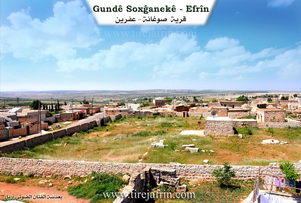
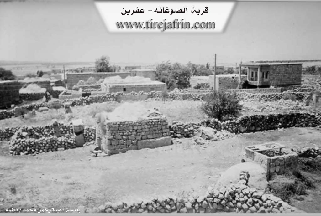
It is a small village among the villages of Çiyayê Lêlûn. It contains remains of numerous antiquities such as building walls, churches, tombs, wells, massive stones, and scattered lintels dating back to the Roman and Byzantine eras. Among its people is the writer and poet Merwan Berekat.
The following is stated in the book عفرين .... نهرها وروابيها الخضراء Efrîn... Her River and Her Green Hills by the writer عبدالرحمن محمد Ebdulrehman Mihemed from the village of Qetme:
Soĝane: A village in Çiyayê Lêlûn belonging to the subdistrict of the villages of the center and region of Efrîn, Heleb governorate. It is a small village located in Çiyayê Lêlûn and the northern chain of Çiyayê Sem‘an. It is bordered to the north by the Çiyayê Lêlûn chain, a deep and rugged valley, and the village of Dêr Mişmiş; to the south by a rugged and rocky mountain chain and the villages of Zer‘a (Zar'antaya) and Berad; to the west by a rocky mountain chain, a valley, and the nearby village of Kîmar; and to the east by a rocky chain of Çiyayê Lêlûn and the town of Eqîbe.
The reconstruction of the area is ancient, indicated by the remains of old Roman walls and towers. Its houses are made of stone with wooden roofs for the old ones, while the new ones are made of stone and reinforced concrete. The number of its houses is 60, and its age is approximately 400 years. There are many archaeological columns in the center of the village and in the southeast direction dating back to the Roman era. An electricity network is available, as well as a paved road passing through its center to the village of Basûte and Efrîn. It has a primary school and a mosque. The people of the village drink from cisterns and collected rainwater.
The villagers work in the cultivation of grains and the raising of sheep and some cows. It is an ancient area that predates the current village in age. One of its most important families is the Berekat family.
Village Mukhtar: Xelîl Berekat Hemo
Preparation and execution:
Manager of Tirej Efrîn site: Ebdulrehman Hacî Osman
20/12/2013
Sources
Book: جبل الكرد (عفرين) دراسة جغرافية Çiyayê Kurmênc (Efrîn): A Geographical Study by د. محمد عبدو علي Dr. Mihemed Ebdo Elî.
Book: عفرين .... نهرها وروابيها الخضراء Efrîn... Her River and Her Green Hills by عبدالرحمن محمد Ebdulrehman Mihemed from the village of Qetme.
II. Summary of Soĝanekê from Ax û Welat
Source: https://www.youtube.com/watch?v=a2yaAhjsa3k
The documentary explores the historical village of Soxanekê located in the Şêrawa district on Çiyayê Lêlûn in the Efrîn region. The name of the district comes from the Şêran tribe. The etymology of the village name has several interpretations. Some attribute it to an Êzîdî tribe named Soxanek originally from Sêwerek in Bakurê Kurdistanê. Others claim it comes from an Aramaic word meaning a place of gathering. However a local historian explains that it derives from the Hewramanî Kurdish word Sohan meaning fear or pain combined with the suffix ek. This name reflects the terrifying and dense forest that covered the area before it was resettled. In 1979 the Syrian regime incorrectly assumed the name was Turkish for onion and arabized it to Beseliyê.
The region boasts a massive historical footprint dating back thousands of years. The nearby Şikefta Duderiyê hosted Neanderthals tens of thousands of years ago. Regional monuments like Perestgeha Eyn Darê and Kela Nebî Hûrî reflect the deep history of the Mitanî and Horî civilizations. The village itself contains ancient signs carved into rocks dating back 3600 years. Following a long period of religious conflicts between Muslim and Christian empires the area was abandoned between 1080 and 1200 AD and turned into a wild forest.
The modern settlement of Soxanekê was reestablished by a man named Mihemedê Berko who arrived with his seven sons and seven sisters to reclaim the ancestral land. Another early settler who helped rebuild the village was Hesûyê Mihemed. The village is predominantly populated by Kurds of the Îzolî tribe along with a family from the Xastiyan tribe. Historically the residents were followers of the Êzîdî faith. Due to severe Ottoman persecution and massacres many villagers converted to Islam out of fear but they preserved numerous ancient Êzîdî traditions such as marking foreheads with soot from the fire and making the sign of the cross over infants as a symbol of the elements of life. Other villages in the region like Basûfanê Kîmarê and Bêyê still have Êzîdî populations.
Surrounding the village are several significant ruins. To the east lies Wariyê Xerbî also referred to as Warê Xirabeyê Nasiran which features two ten meter towers seven cisterns and a cave. To the south is the uninhabited ruin of Xirabeyê Kokebe containing a large water pool four caves and a collapsed church. Other notable sites include the ruins of Qesra Sêlîn and the affiliated settlement of Dêrmişmiş where five families from Soxanekê relocated.
Today the villagers rely primarily on agriculture and livestock. They cultivate wheat barley lentils and olives and the women produce traditional dairy products like butter and cheese. Despite the passage of time the people of Soxanekê continue to maintain their traditional Kurdish clothing and deeply rooted cultural practices.
Transcriptions and Subtitles
| Source | Video | Subtitles | Transcript |
|---|---|---|---|
| Ax û Welat 1 | Watch Video | Download SRT | View Transcript |
Foundation/Origin Information of Soĝanekê
The inhabitants of Soughaneh were Yazidis in the late 19th century.
Source: TirejAfrin Site
Possible Village Name Meaning of Soĝanekê
Soughan: In Turkish means "onion or bulb" Soğanak. The origin of the name is Soxĝanê, which is the name of a Kurdish Yazidi tribe belonging to the Qatani group.
Source: TirejAfrin Site