General Information
Nahiya (Subdistrict)
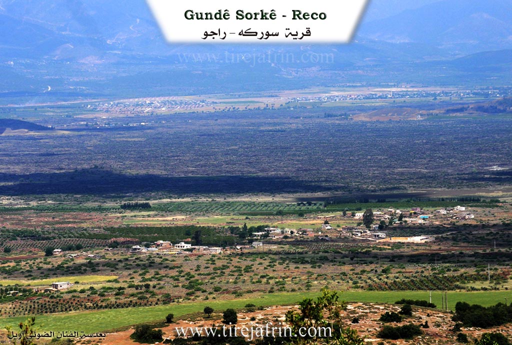
Reco
Also Known As
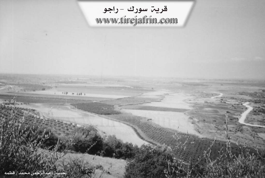
Al-Sur, Sorkê, Surka, Surkê, Sûrké, السور, سوركه

Photos
Basic Information about Sorkê
Source: Tirej Afrin
Etymology: The name means "The Red One" (Sor / Surk), an attribute describing the village site which possesses red soil within the volcanic Lîçe plain
Foundation Date/Period: 50 years old
Springs: Betman
Ruins: Tel Keşor, Semaq
Other Landmarks: Deşta Lîçe, Geliyê Sarisn
Summaries
I. Summary from TirejAfrin Site (English) of Sorkê
Source: https://www.tirejafrin.com/site/kura%20afrin%20%20%20Reco%20-%20sorka.htm
It is stated in the book Çiyayê Kurmênc (Efrîn): A Geographical Study: Surk, Surk, El-Sûr / 91 inhabitants 260m /:
Surk: Meaning "The Red One," and the name is an attribute for the site of the village which possesses red soil in the middle of the volcanic Lîçe plain.
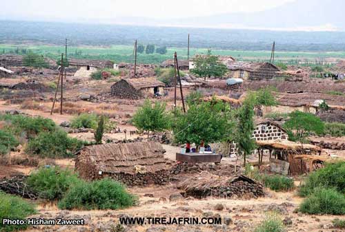
The village consists of about twenty dwellings, most of them roofed with straw or Zinc. It is located at the western end of the Sarisn valley.
It is stated in the book Efrîn... Her River and Her Green Hills: Surk is a village in Çiyayê Kurmênc following the township of Reco, region of Efrîn, governorate of Heleb. It is a small village located in the western section of Çiyayê Kurmênc and near the borders of Turkiye a few meters away. It is modern; its inhabitants migrated from the old ruined village of Tel Keşor after the separation of the Sancaxa Îskenderûnê from Sûriye.
It is situated in a fertile agricultural plain due to its proximity to the Çemê Reş. It is bounded to the north by the site of the original ruined village of Tel Keşor, the Turkish border directly, and the spring of Betman. It is bounded to the south by a fertile agricultural plain planted with vegetables irrigated from the Çemê Reş and the village of Şediyanli. It is bounded to the east by a high mountain chain and the ruins of Semaq. It is bounded to the west by a plain, the Çemê Reş, and the Turkish border directly 300 meters away.
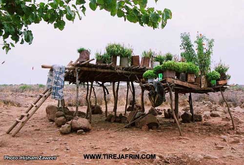
The number of its houses reaches 20 houses and its age is about 50 years. Its houses have roofs made of reeds and mud, and currently of cement and stones. An electricity network, a modern primary school, and a leveled unpaved dirt road are available there. The village consists of plateaus, depressions, and black basalt stones. The residents work in rainfed agriculture (grains, legumes), and irrigated farming from the Çemê Reş and from the course of Kaniya Betman (trees: pomegranate, walnut, apricot) and vegetables, alongside raising sheep and goats.
Sources of Information:
- Book: جبل الكرد (عفرين) دراسة جغرافية Çiyayê Kurmênc (Efrîn): A Geographical Study by د. محمد عبدو علي Dr. Mihemed Ebdo Elî.
- Book: عفرين .... نهرها وروابيها الخضراء Efrîn... Her River and Her Green Hills by عبدالرحمن محمد Ebdulrehman Mihemed from the village of Qetme.
- Studies of Navenda Tirej Soft / Ebdulrehman Hacî Osman.
- Some residents of the villages.
Preparation and Execution: Manager of the website Tirej Efrîn: Ebdulrehman Hacî Osman 20/12/2013
II. Summary of Sorkê from Multi Channel
The documentary provides an intimate look into the agricultural life and history of Şirkê, a historic village located in the Afrin region. Through the testimonies of its residents, the film illustrates the deep connection between the villagers and their ancestral lands.
According to village elder Hikmet Osman, Şirkê has existed for four hundred to five hundred years. He explains that the settlement originally began as a small private farm owned by his forefathers. Over time, the location expanded as more people arrived and settled there, eventually growing into a permanent and flourishing village. The land itself is situated in a volcanic zone, characterized by its dark and highly fertile soil.
Water plays a central role in the survival and prosperity of the village. A primary water source is a spring and channel known locally as Batman, which flows through the heart of Şirkê. The Batman spring provides essential irrigation for thousands of crops and agricultural plots. Historically, the village was renowned throughout the region for its water mills. Because surrounding settlements lacked their own milling infrastructure, residents from neighboring villages such as Meydanan, Omerkankan, and Mameran would travel to Şirkê to grind their grain into flour.
The documentary extensively features a female resident named Leman, whom the narrator also introduces as Berûx. She offers a detailed narrative of the daily labor required to sustain a farming household. Her family relies on cultivating crops like wheat, barley, tomatoes, and eggplants, alongside herding sheep for milk, yogurt, and cheese. While preparing traditional dishes, Leman contrasts the hardships of current times with the abundance of the past.
She fondly recounts the vibrant social life of earlier decades, particularly the traditional village weddings. These celebrations would stretch across multiple days and nights, filled with music, customary garments, and shared feasts. During such events, families in Şirkê and neighboring communities like Şadiya would distribute the responsibility of hosting guests, ensuring everyone was fed and welcomed.
Despite modern economic challenges, the community remains rooted in its traditions. Leman mentions her son Mihemed, who resides in the nearby town of Raco but still returns to assist with farming, livestock, and transportation. Through these personal accounts, the documentary captures the enduring agricultural heritage, the warmth of rural hospitality, and the rich historical memory embedded within the village of Şirkê.
Transcriptions and Subtitles
| Source | Video | Subtitles | Transcript |
|---|---|---|---|
| Multi Channel 1 | Watch Video | Download SRT | View Transcript |
Foundation/Origin Information of Sorkê
It is of recent era, its inhabitants migrated from the old ruined Tell Kashur village after the separation of Alexandretta district from Syria.
Source: TirejAfrin Site
The Delikan (Dêlîkan) tribe, a nomadic (Koçer) community, traces its origins back to a migration from the Hakkari (Hekarî) and Muş (Mûş) regions of Northern Kurdistan. After passing through Suruç and the Manbij area, they settled in the village of Sorkê.
Source: Ax û Walat Transcript
Possible Village Name Meaning of Sorkê
Surk: meaning "the red one," and the name is a description of the village site with red soil in the middle of the volcanic Liçe plain.
Source: TirejAfrin Site
No information provided in this source.
Source: Ax û Walat Transcript
V. Links
- Tirej Afrin:
https://www.tirejafrin.com/site/kura%20afrin%20%20%20Reco%20-%20sorka.htm - Drone:
https://www.youtube.com/watch?v=JFEh8S58O4o (no longer available) - Video:
https://www.youtube.com/watch?v=y9HtRrFOZ70 - Link:
https://www.youtube.com/watch?v=Yj3tG6DcyU4