General Information
Nahiya (Subdistrict)
Efrîn
Also Known As
Turindê, الظريفة, ترندة, ترنده, طرندة
Families, Clans, etc.
Ebdulo, Hemke, Mala Ebû Şiyar, Mala Hesen Cefo, Mala Hesen Elî Qido, Qedo, Qehwe, Reşo, Sîdo, Şêx Hes

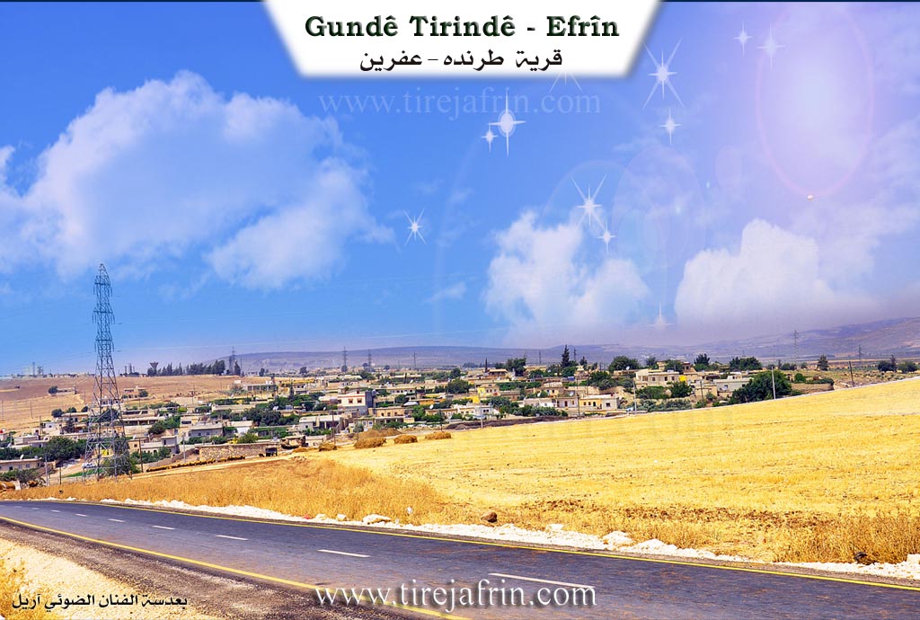
Photos
Basic Information about Turindê
Source: Afrin 366
Ruins: Dîwarê Qoban
Wells: Bîra Hesen Cefo
Other Landmarks: Sehê Tirindê, Parka Surê, Firnê Zer, Mefreqa Cûqê, Cisrê Efrînê
Summaries
I. Summary from TirejAfrin Site (English) of Turindê
Source: https://www.tirejafrin.com/site/kura%20afrin%20markaz-%20turinde.htm
The following is stated in the book جبل الكرد (عفرين) دراسة جغرافية Çiyayê Kurmênc (Efrîn): A Geographical Study by د. محمد عبدو علي Dr. Mihemed Ebdo Elî: Turind, Trinde, Al-Zerîfe /3330 inhabitants - 3km - 260m/:
The Popular Name "Trinde"
Trinde is also the name of an ancient city located southwest of the city of Meletî in Turkey. It was an important Byzantine center, then controlled by Muslims in the early period of their era in the year 83 AH/702 AD. They destroyed it and displaced its people during the reign of the Umayyad Caliph Omer bin Ebdulezîz, and perhaps some of the current inhabitants of the village of Trinde are descendants of those people. Also, "Derende" or "Trinde" in Kurdish means "the vagabond or the wild." In addition to what was mentioned, there is a resemblance of the name to Syriac names if written in the form "Turinde" or "Tûrinde", as "Tûr" means "mountain." Furthermore, "nd" is a Hittite suffix for geographical names. However, it is certain that the name is not Arabic, and the Arabized name "Al-Zerîfe" has no connection to the ancient name of the village; the translators believed that Trinde meant "nice or beautiful" (zarîf) in the Kurdish language, and it was translated in light of that.
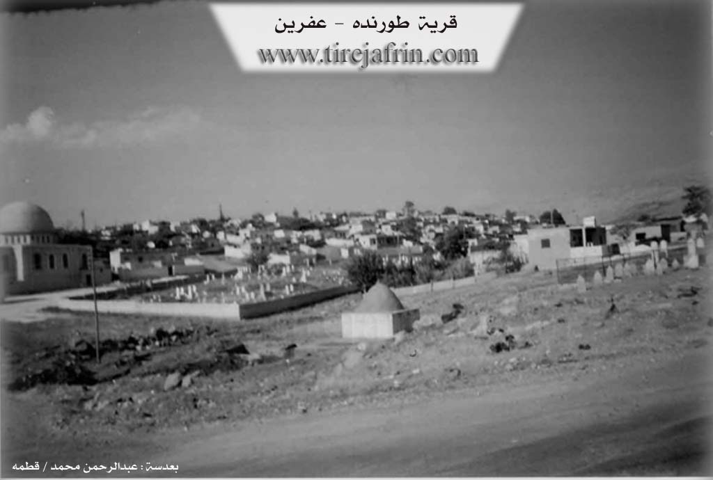
It is a large village that was included in the zoning plan of the city of Efrîn in 2002. Its inhabitants work in agriculture, and they were the first to plant potatoes in the Efrîn region. Its deep valley passes to its south, and at its end was the Trinde spring (Kaniya Tirindê), known for its sacred fish and its abundance (2 liters/second). Next to the spring site is the shrine of Ebdulqadir Kêlanî and the village cemetery. Huge building stones appear through excavation works at the top of the hill where the village threshing floors are located, indicating ancient habitation at this site.
The following is stated in the book عفرين .... نهرها وروابيها الخضراء Efrîn... Her River and Her Green Hills by the writer عبدالرحمن محمد Ebdulrehman Mihemed from the village of Qetme:
Trinde: A village in the Cûme plain and Efrîn valley, administratively belonging to the villages of the center and the Efrîn district, Heleb governorate. It is large, situated on the eastern bank of the Efrîn river and on a plateau with black basalt soil. It is bordered to the north by a mountain range, a fertile plain, and the villages of Erşqîbar and Cûmkê; to the south by a wide and fertile plain and the tourist village of Eyn Dara; to the east by the mountain range of Çiyayê Siman and Çiyayê Lêlûn and the village of Xaldiye; and to the west by a plain, the course of the Efrîn river, and the city of Efrîn.
The number of its houses is about 100, and its age is about 400 years. Its old houses are of stone and mud with wooden roofs, while the modern ones are spread along the Efrîn road. An electricity network and drinking water via the state are available. Its paved road passes through its center to Basûte and neighboring villages. It has a primary school, a modern mosque, and a telephone center. There is a shrine west of the village (Mezarê Ebdulqadir Kêlanî) next to the spring. The village of Trinde is one of the ancient villages, evidenced by the presence of archaeological sites from ancient times at the village location. Its inhabitants work in the cultivation of cereals, cotton, and sugar beet, irrigated via the Efrîn river and artesian wells, as well as raising sheep and goats. Currently, it has become one of the southern neighborhoods of the city of Efrîn.
Among its most important families are the families of: Ebdulo, Qedo, Qehwe, Şêx Hes, Hemke, Reşo, and Sîdo. The mukhtar of the village is Kenco Ehmed Sîdo (it is mentioned that the first mukhtar of the village was the late Kemal Silo Ebdulo).
Sources:
- Book: جبل الكرد (عفرين) دراسة جغرافية Çiyayê Kurmênc (Efrîn): A Geographical Study by د. محمد عبدو علي Dr. Mihemed Ebdo Elî.
- Book: عفرين .... نهرها وروابيها الخضراء Efrîn... Her River and Her Green Hills by عبدالرحمن محمد Ebdulrehman Mihemed from the village of Qetme.
Preparation and Execution:
- Manager of the Tirej Efrîn site: Ebdulrehman Hacî Osman
- 20/12/2013
II. Summary of Turindê from Afrin 366
Source: https://www.youtube.com/watch?v=aL2McAwgs-Y
The documentary focuses on the locality of Tirinde, specifically an area referred to as Sehê Tirindê, situated on the immediate outskirts of the city of Efrîn. The narrative serves as both a social visit and a travelogue, documenting the lives of remaining residents and the changing landscape of the region. While the transcript does not provide a specific foundation date for the village, it highlights the area's close connection to the broader Efrîn region, mentioning nearby villages such as Basûtê, Kerzêlê, and Kîmor.
The social structure depicted in the footage centers on the household of Mala Hesen Elî Qido. The host specifically visits Mala Ebû Şiyar, where he interviews an elderly couple who represent the older generation of Kurmanc residents. A significant portion of the conversation revolves around the impact of migration and displacement; the matriarch of the family laments that her five children (three sons and two daughters) have been living abroad in places like Europe and Iraq for over a decade. The host also sends greetings to a sponsor, Mafruşat Ibo, noting his origins in the nearby village of Dêrsewan.
Daily life in Tirinde is shown to be challenging but resilient. The residents discuss the scarcity of water, noting that "company water" arrives only once a week. There is a specific mention of a local well, Bîra Hesen Cefo, which has unfortunately gone dry ("heş kû ye"), symbolizing the agricultural difficulties facing the community. Despite this, the host notes the greenery of the courtyard and the persistence of the residents.
The documentary also captures the physical transformation of the area between Tirinde and the city center of Efrîn. The host observes a rapid shift from traditional orchards and single-story homes to multi-story concrete buildings ("bînayet"). As the crew travels toward the city market ("Çarşî"), they pass several notable landmarks. These include Dîwarê Qoban (The Wall of Qoban), the main bridge (Cisr), and the Firnê Zer (Yellow Bakery). The tour concludes near the Mefreqa Cûqê (Cûqê Intersection), marked by a statue of an olive, emphasizing the region's agricultural identity even amidst heavy urbanization.
II. Ax û Walat Book 1
21
THE VILLAGE OF TIRINDÊ
19/4/2016
The village of Tirindê has been a neighborhood attached to the city of Efrînê since 1990, located on the southern side of the city. The name of the village means ((High Hill)) as specified in the KURDISTAN dictionary.
According to the book of (Ibn El Esîr), the village of Tirindê was destroyed twice during both the Roman and Islamic periods.
The village of Tirindê consists of 2 parts: Upper and Lower. The Lower part is ancient, but the Upper part has been built in a modern style,
22
so one can say that the village of Tirindê experiences both village and city life at the same time.
The inhabitants of the village are composed of Muslim and Êzdî Kurds, along with one Arab family. They all live together in good and balanced relationships, therefore, during holidays and celebrations, they all participate as one family, and likewise, in times of sorrow and grief, they support each other.
There are 8 families in the village:
The family of Evdalê, El Qehwe, Qedê, Hemkê, Reşo, Naso, Ne’sê and the family of Neêmî whose origins are Arab. The majority of the village's families are from the Şerqî and Milî tribes.
There are around 250 houses in the village, and about 1800 people live there.
To the west of the village is the Efrînê river, to the east is the Lêlûn mountain, to the south are the villages of Kurzêlê and Endarê, and to the north are the Eşrefiyê neighborhood and the village of Qîbarê.
At the bottom of the village on the west side, there is the Qirê valley, which joins with the Erşê valley under the name of the Tirindê valley.
23
There is a water spring at the bottom of the village named (the spring of Tirindê), and also the Shrine of Şêx Ebdilqadirê Gîlanî is within the village, and a very ancient pilgrimage site in the village named (Ziyaratok) is visited by villagers for luck and wishes on Wednesdays.
Due to the richness of their lands with soil and water, the villagers make their living from agriculture, primarily cultivating grain fields of barley and wheat, along with planting all types of vegetables such as potatoes, onions, eggplants, watermelons, peppers, and fruit trees like pomegranates, apples, peaches, mangoes, plums, and apricots.
It is worth mentioning that the village of Tirindê is famous for potato cultivation. All the farmers in the village own modern agricultural equipment such as tractors, threshers, harvesters, and agricultural vehicles.
24
In addition to these, some farmers also own olive trees. The village farmers irrigate their fields with water from a canal that comes from the Meydankê dam, and there are also many water wells in all the fields for irrigation, and it is said that water emerges at a depth of only 10 meters in the village's areas.
Along with agriculture, some families in the village raise livestock such as sheep, goats, and cows, and they sell their products of milk, yogurt, and cheese in the shops and markets of Efrînê.
Also, nearly 100 people work in the sewing workshop in the village, and many people work in various other workshops. Some people also work as employees in the institutions and bodies of the Autonomous Administration.
There are 3 martyrs who were martyred in the Freedom Revolution:
Ş. Sêfedîn, Mehmûd and Rûmet.
The village commune has been named after Ş. Sêfedîn, which focuses on organizing the villagers and solving their problems.
There is a mosque, a primary school, and a commune building in the village.
The village of Tirindê is famous for its large number of intellectuals, including doctors, engineers, lawyers, teachers, and holders of higher degrees in all fields.
25
Red Wednesday:
Şêx Heyder is known as an Êzdî sheikh in the village, and during religious holidays, he recites verses, prayers, and blessings and celebrates the holiday. One of the most famous Êzdî holidays is the holiday of (Çarşema Sor).
According to Êzdî mythology, "God finished creating the universe on a Wednesday in the month of April, and it is said that the gates of goodness are open on Wednesday from morning until evening."
On this day, the Êzdî people slaughter sacrifices and distribute food to poor families, and they also decorate the doors of their houses with flowers and blossoms.
It is worth remembering that on that day, eggs are colored, because the egg is a symbol of the roundness of the earth, and because all the components of the earth are present in the egg, as well as the life that emerges from it, and the coloring of the egg is also a sign of the richness and diversity of nature in the month of abundance.
Transcriptions and Subtitles
| Source | Video | Subtitles | Transcript |
|---|---|---|---|
| Afrin 366 1 | Watch Video | Download SRT | View Transcript |
Possible Village Name Meaning of Turindê
The popular name "ترندة": ترندة is also a name for an ancient city located southwest of "Malatya" city in Turkey, and it was an important Byzantine center, then the Muslims conquered it in the early period of their era in 83H/702AD. Perhaps some inhabitants of current Q. Taranda were descendants of those people. Also "درندة" Derende or "ترندة" in Kurdish means "the refugee or the displaced". In addition to what was mentioned, there is a resemblance of the name to Syriac names if written as "ترندة – طورندة", so "طور = mountain". Also "ند" is a grammatical suffix for geographical names. But it is certain that the name is not Arabic, and there is no connection of the Arabized name "الظريفة" to the old name of the village, where the translators believed that ترندة means "nice or beautiful" in Kurdish, and it was translated accordingly.
Source: TirejAfrin Site
V. Links
- Tirej Afrin:
https://www.tirejafrin.com/site/kura%20afrin%20markaz-%20turinde.htm - Local FB page:
https://www.facebook.com/Tirindii - Drone:
https://www.youtube.com/watch?v=J_sGw5JeU_I - Video:
https://www.youtube.com/watch?v=lWApHJeIXFQ - Link:
https://www.youtube.com/watch?v=hWOik-QVXL4 - Afrin 366:
https://www.youtube.com/watch?v=aL2McAwgs-Y