General Information
Nahiya (Subdistrict)
Şera
Also Known As
Al-Baya'a, Wirkan, Wêreganê, Wîregan, البياعة, ويركان, ويركان، فيركانه, ويركن, ويره كان, فيركان
Tribes
Cêriyat
Families, Clans, etc.
Betal, Hec Umer, Hemade Benawiyê, Herîk Şêx, Kirêzlî, Kor, Mesela, Mihemed Deran, Milhem, Soran, Uceylî
Photos
Basic Information about Wêreganê
Source: Tirej Afrin
Etymology: Wêrgan: Means wolf in the ancient Persian language. In Turkish, it means the seller or giver. The Arabized name El Beyaah is a translation of the supposed Turkish naming of the village.
Foundation Date/Period: Approximately 350 years ago
Hills: Telîlaq
Ruins: Telîlaq
Other Landmarks: Geliyê Cehenem, Çemê Sabûn, Pira Romî
Summaries
I. Summary from TirejAfrin Site (English) of Wêreganê
Source: https://www.tirejafrin.com/site/kura%20afrin%20%20sheran%20-%20wergana.htm
It is stated in the book Çiyayê Kurmênc / Efrîn / A Geographical Study: Wregan, Wêrkan, El Beyaah /441 inhabitants, 460m altitude, 10km distance/.
Wêrgan: Means wolf in the ancient Persian language. In Turkish, it means the seller or giver. The Arabized name is a translation of the supposed Turkish naming of the village.
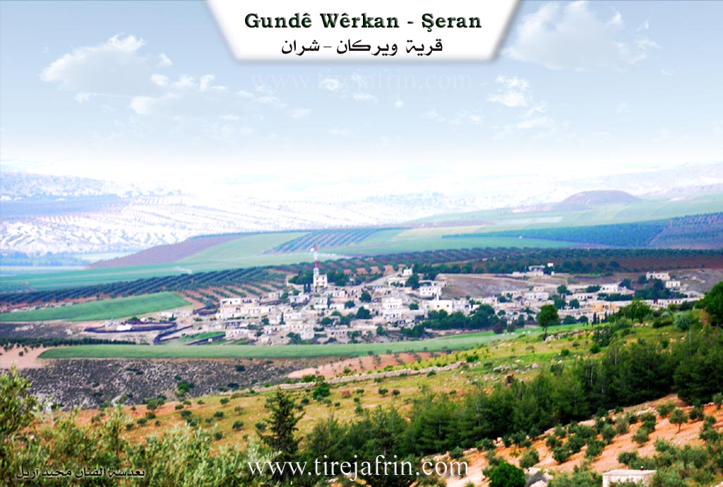
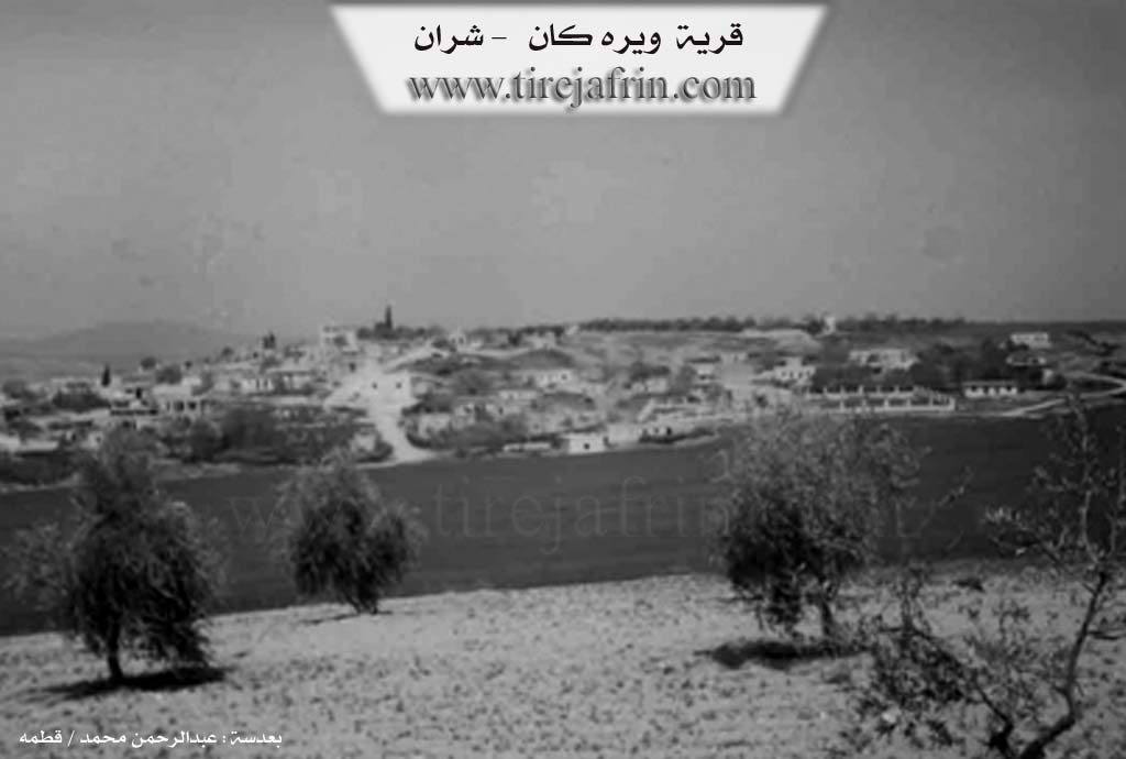
It is a small village located on a slope descending west towards the Efrîn river. South of the village, there is an archaeological hill called Telîlaq. Foundations of archaeological buildings appear next to it.
It is stated in the book Efrîn... Her River and Her Green Hills: Wêrkan is a village in Çiyayê Kurmênc, affiliated with the Şera district, Efrîn region, Heleb governorate (412 inhabitants). It is a small village located in the northern part of Çiyayê Kurmênc, on the southwestern slope of a limestone plateau of low elevation. It slopes south towards agricultural lands in the direction of Geliyê Cehenem (Hell Valley), which ends westward in the valley of the Efrîn river. It is 10km away from the town of Şera towards the northeast.
The settlement of the area is ancient, evidenced by the presence of an archaeological hill south of the village called Telîlaq where foundations of ancient buildings appear. It is bordered on the north by an agricultural plain, a valley, and the course of the Efrîn river coming from under the Roman bridge, called Çemê Sabûn, and the village of Dêr Sewan. It is bordered on the south by the deep Geliyê Cehenem, a mountain range, the village of Telîlaq El Senoberiyê, and the village of Omranlî. It is bordered on the east by a valley, a mountain range of olive trees and forest trees, the village of Ereb Wêran, and the farm of Mezreya Cemîl. It is bordered on the west by a valley, the course of the Efrîn river, and the village of Bilêlûrsink El Bilêlûriye.
The number of its houses is about 40 houses and its age is about 350 years. Its old houses are made of stone, mud, and wooden ceilings, and the modern ones are of cement and stone. An electricity network, a primary school, and a paved road to the district center are available in it. It belongs to the municipality of Dêr Sewan.
The residents drink from artesian wells. Its inhabitants work mainly in the cultivation of olives, vines, grains, and livestock raising. There is an agricultural society in the village. Among its most important families is the Mihemed Deran family. It is one of the beautiful villages located next to the Efrîn river and the Pira Romî (Roman Bridge) erected over the Efrîn river, situated on the southwestern side of the bridge.
Sources of Information:
- Book: جبل الكرد ( عفرين ) دراسة جغرافية Çiyayê Kurmênc (Efrîn): A Geographical Study by للدكتور محمد عبدو علي Dr. Mihemed Ebdo Elî.
- Book: عفرين .... نهرها وروابيها الخضراء Efrîn... Her River and Her Green Hills by للكاتب عبدالرحمن محمد Ebdulrehman Mihemed from the village of Qetme.
- Studies of Navenda Tirej Soft / Ebdulrehman Hacî Osman.
- Some residents of the villages.
Preparation and Execution: Manager of the website Tirej Efrîn: Ebdulrehman Hacî Osman 20/12/2013
II. Summary of Wêreganê from Multi Channel
The documentary explores the village of Werqan, also referred to by its Arabic name Beyace. Located near the town of Şera and the city of Efrîn, the village is built across the slopes of a medium mountain. The surrounding landscape features prominent geographic and historical landmarks. To the south lies the steep and deep valley of Geliyê Cehennemê, which separates Werqan from the neighboring settlement of Eyn Elo. The residents have historically relied on a local spring called Kaniya Gund to water their flocks and crops. The broader region is filled with ancient sites, including the Roman bridges spanning the waters at Ereb Wêran and Dêr Siwan, as well as the ancient fortress of Kela Nebî Hûrî.
The true foundation of Werqan dates back to the mid Ottoman period, with the current settlement taking shape around one hundred years ago. It was originally established by nomadic herdsmen who settled near the local springs to water their livestock. Over time, the inhabitants transitioned to agriculture. During the feudal era, the village lands were owned by outside landlords. Mirad Axa of the Milhem family arrived from Qerenbe, while Arif Axa from the Hec Umer family came from Dêr Siwan. The villagers worked the land as sharecroppers until agrarian reforms redistributed the properties directly to the farmers.
Today, the village is home to a diverse community where Kurdish and Arab families coexist harmoniously. Turkmen residents also lived there in the past but eventually relocated. The Arab population includes the Cêriyat tribe alongside the Uceylî and Hemade Benawiyê families. The Kurdish population consists of the Soran, Kor, Kirêzlî, Betal, and Herîk Şêx families. Another group known as Mesela previously inhabited the lower section of the village before moving away. The community maintains close social ties, frequently assisting each other during the harvest seasons and celebrating mixed weddings in the main square where both Kurdish and Arab songs are sung.
The village has grown from thirteen traditional mud brick houses to approximately one hundred modern homes. The population of five hundred now includes displaced Arab families from the southern Heleb countryside, particularly from areas like Zerbe, Tel Eldeman, and Şûhe. These newcomers live in tents or rented houses and work as agricultural laborers.
The local economy relies on cultivating olives, pomegranates, grapes, and grains, alongside raising Awassi sheep and mountain goats. The village is also renowned for a traditional stew called Boranî. As local elder Gulîzar Bekir describes, this hearty dish is prepared by boiling a mixture of yogurt, lentils, chickpeas, wheat, eggplants, tomatoes, and peppers. While the village has only a primary school managed by Hanan Îsmaîl and formal education rates are low, the older generation possesses a deep cultural richness. For example, village elder Mehmûd Ebdo displays a profound knowledge of history, having read extensively about global politics, socialism, and philosophy.
Transcriptions and Subtitles
| Source | Video | Subtitles | Transcript |
|---|---|---|---|
| Multi Channel 1 | Watch Video | Download SRT | View Transcript |
Foundation/Origin Information of Wêreganê
The settlement of the region is ancient evidenced by the presence of an archaeological tell south of the village called Talilaq where ancient building foundations appear.
Source: TirejAfrin Site