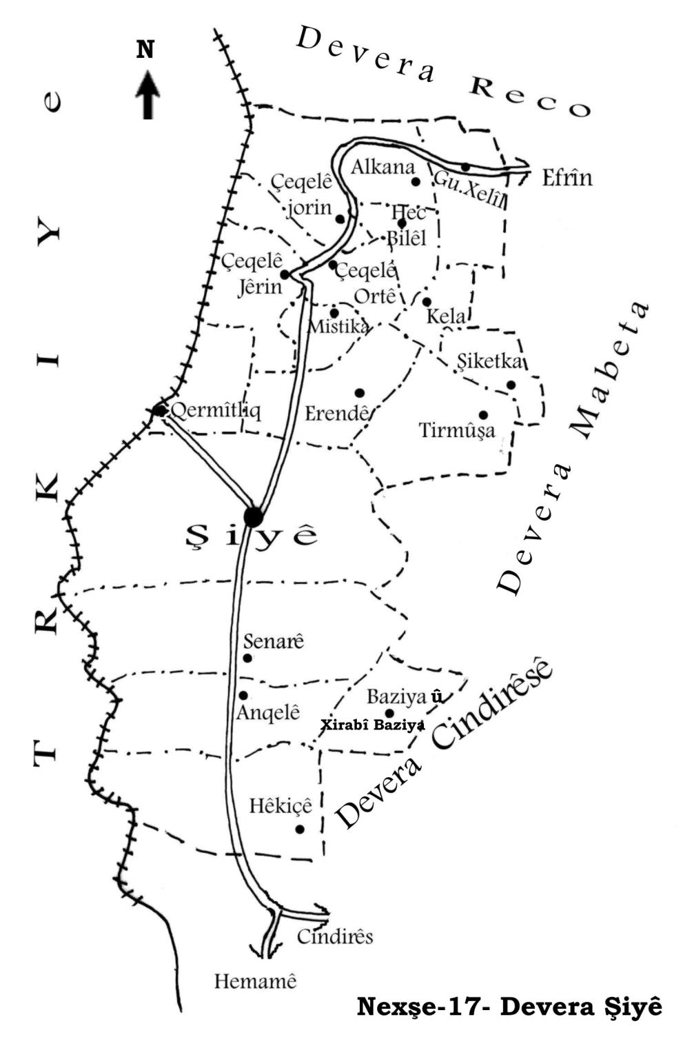
General Information
Nahiya (Subdistrict)
Şiyê
Also Known As
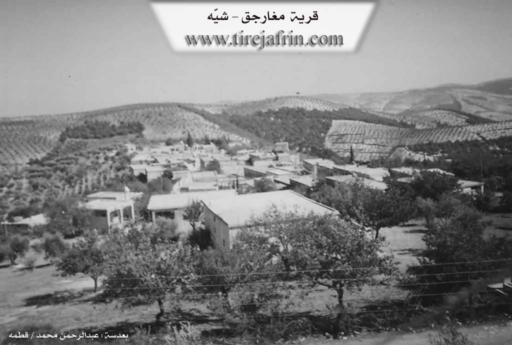
Magharjiq, Şikefta, Šiketka, مغار, مغارجق, شكاتو
Families, Clans, etc.
Beşîr, Daxlî, Elî, Gencû, Hedo, Keso, Kor Reşîd, Mala Dêxlê, Mala Ehmedê Kurd, Mala Koso, Mala Silêman Farûq, Mala Sêlev, Mala Usib 'Elîm, Omerê Husê, Xelîfo
Photos
Basic Information about Şiketka
Source: Khalil Sino
Etymology: Derived from the word "şikeft" (caves), as the original inhabitants lived in caves before constructing houses
Summaries
I. Summary from TirejAfrin Site (English) of Şiketka
Source: https://www.tirejafrin.com/site/kura%20afrin%20%20%20shiye%20-%20shketka.htm
It is stated in the book جبل الكرد (عفرين) دراسة جغرافية Çiyayê Kurmênc (Efrîn): A Geographical Study by د. محمد عبدو علي Dr. Mihemed Ebdo Elî: Şiketka, Mugharjiq /879 inhabitants - 720m/:
Şiketka: The name means "the caves" in Kurdish. The early inhabitants of the village used to live in the caves found beside the village, and the village was named after them. The naming before Arabization is Turkish in origin and has the same meaning.
It is a small village located on the summit of a highland overlooking the Xastiya valley from the south.
It is stated in the book: عفرين .... نهرها وروابيها الخضراء Efrîn... Her River and Her Green Hills by the writer عبدالرحمن محمد Ebdulrehman Mihemed from the village of Qetme:
Mugharjiq: A village in Çiyayê Kurmênc, belonging to the Şiyê subdistrict, Efrîn region, Heleb governorate. It is a small village located at the end of the eastern slope of the middle section of the mentioned mountain, on a limestone rocky flat; its soil is clay. It is 5km away from the town of Şiyê towards the northeast.
It is bordered to the north by a mountain chain planted with olive trees and the village of Meserê Cîq, to the south by a very deep watercourse and the village of Turmişkanli at the top of the mountain, to the east by a deep valley, a high mountain chain, and the village of Mistû Aşûr, and to the west by a valley, a mountain chain, and the village of Erendê.
The number of its houses amounts to about 60 houses, and its age is about 350 years. Its dwellings are stone and mud with flat wooden roofs. Modern dwellings are spreading within the courtyards of the old building and around it. An electricity network and a primary school are available in it, as well as drinking water from a well belonging to the state. The residents work in rain fed agriculture such as olives and vines on an area amounting to 295 hectares, alongside sheep rearing. There is an olive press in it.
It connects to the center of the subdistrict via a paved and winding road 9km in length. It is a beautiful village in terms of location and the forests surrounding the village.
Village Mukhtar: Mihemed Kaso Mihemed
Sources:
- Book: جبل الكرد (عفرين) دراسة جغرافية Çiyayê Kurmênc (Efrîn): A Geographical Study by د. محمد عبدو علي Dr. Mihemed Ebdo Elî.
- Book: عفرين .... نهرها وروابيها الخضراء Efrîn... Her River and Her Green Hills by عبدالرحمن محمد Ebdulrehman Mihemed from the village of Qetme.
Preparation and execution:
- Manager of Tirej Efrîn site: Ebdulrehman Hacî Osman
- 20/12/2013
II. Summary of Şiketka from Khalil Sino
Source: https://www.youtube.com/watch?v=Q0bJQ2g4HU4
The village of Şikefta (referred to locally as Şiketka) in the Afrin region carries a name deeply rooted in its settlement history. According to the elder Mihemed, who is seventy five years old, the name is derived from şikeft (caves). In the earliest era of the settlement, the inhabitants did not possess constructed homes but instead lived inside the natural caves found at the site. It was only later that the community moved out of the rock shelters to build the stone masonry village that exists today. Mihemed estimates that the constructed houses, specifically the historic ones featuring traditional architecture, date back approximately 110 years.
The social fabric of Şikefta is composed of several distinct families. A resident named Mistefa identifies Mala Ehmedê Kurd as the "xwedanê vî gundî" (the owners or foundational family of the village). Other prominent lineages include Mala Dêxlê, Mala Koso, and Mala Sêlev. The oral history preserves specific details about migration; for instance, the Mala Usib 'Elîm family is noted to have originally come from a place called Cîkûr. This family reportedly had daughters but no sons initially, eventually marrying their daughters into other groups like Erebo and Erendê.
Architecturally, Şikefta was known for its "kîbar" (noble/fine) stone houses featuring "qentere" (arches) and "qopîk" (domes or vaulted small rooms). Mihemed describes a specific historic house built by his ancestor, Silêman Farûq, which served as a center for storage and living. Tragically, the recent earthquake caused significant destruction to these heritage sites, collapsing the arches and ruining the interiors that once held large jars for oil and grain storage.
Daily life in the historical Şikefta was characterized by hard labor ("cefa"), as recounted by the female elders Mexbûle and Fatme. Before modern amenities, women hauled water from the springs in the valley using animals, baked bread in a "tenûr" (tannur oven), and washed clothes in the wild. The village is also known for its agricultural production, specifically the making of "leçer" (preserves or molasses) from figs, pumpkins, grapes, and eggplants. Today, the demographic landscape has shifted significantly. While the village contains around 75 houses, only about 40 families currently reside there, with many original inhabitants having migrated to Heleb, Efrîn, Libnan, or Tirkiye. Despite the modernization of infrastructure like wells and electricity, the elders look back on the communal spirit of the past with nostalgia.
II. Summary of Şiketka from Ax û Welat
Source: https://www.youtube.com/watch?v=TRA9VSRsegU
The documentary explores the history and social fabric of Şkêfta, a village in the Şiyê district of the Efrîn region. The name of the village translates to caves and stems from its unique origin. Around 350 years ago, the area was settled by three main families who lived inside large natural caves rather than built houses. These foundational families were Keso, Daxlî, and Omerê Husê. Later, the Xelîfo family arrived from the village of Çomaza and constructed the first actual house in the village. This initial house was built by Ebdî Xelîfo. Over time, particularly in the 1920s, the remaining cave dwellers followed suit and moved out to build homes closer to the local springs.
The village is situated near several critical water sources, including Kaniya Deştê, Kaniya Derkê, and Kaniya Qelembacikê. It shares borders and water access with the neighboring village of Tirmîşa. Between Şkêfta and Tirmîşa lies a valley called Geliyê Erdê Sor, where an unnamed ancient shrine is located. Despite its name being lost to time, locals hold the shrine in high regard, bringing offerings to seek cures for illnesses or to pray for fertility.
Agriculture has always been the backbone of Şkêfta. Originally, the villagers relied on sheep herding, vineyards, and producing charcoal to sell in areas like Şêrawa. Today, they cultivate olive trees alongside fruits like apples, peaches, and apricots. A prominent historical feature of the village was an ancient olive press located inside the cave belonging to the Kor Reşîd family. This press operated for over fifty years and remains a testament to the village agricultural past.
The documentary also highlights traditional practices and historical memories. Women of the village continue to bake a festive bread called kumbac over open fires. An older woman originally from Hec Xelîl recalls the extreme poverty of her youth, contrasting it with modern abundance. A village carpenter named Seîdê Mihemed Hîdo preserves the craft of making traditional wooden agricultural tools and metal beehive smokers.
Elders recount tales of survival during the Osmanî period and the later Frensiz mandate. To hide their grain, lentils, and tobacco from oppressive tax collectors, every house in Şkêfta had a secret storage pit dug into the floor. Families like Gencû and Hedo would cover these pits with stones, seal them with mud, and lay mats over them to deceive the authorities. The narrator further links the area to ancient history, noting that the broader region was home to early civilizations like the Mîtanî and Huri, leaving behind Romanî ruins such as Pireya Qestentînî.
Transcriptions and Subtitles
| Source | Video | Subtitles | Transcript |
|---|---|---|---|
| Ax û Welat 1 | Watch Video | Download SRT | View Transcript |
| Khalil Sino 1 | Watch Video | Download SRT | View Transcript |
Foundation/Origin Information of Şiketka
The village's first inhabitants used to live in caves existing beside the village and the village was named after them.
Source: TirejAfrin Site
The village was founded by three brothers from the families of Hawî, Dîxlê, and Koso Elî, who purchased the land from an Arab family known as Malê Wîsê Birîm.
Source: Halil Sino Transcript
Possible Village Name Meaning of Şiketka
Šiketka means "caves" in Kurdish. The pre-arabization name is Turkish in origin (Magharjiq) and with the same meaning.
Source: TirejAfrin Site
The name derives from the Kurdish word for cave ("şikeft"), tracing its origins to inhabitants who lived in caves before the current settlement.
Source: Halil Sino Transcript