General Information
Nahiya (Subdistrict)
Efrîn
Also Known As
Al-Mastora, Astaro, Gu.Astêr, Stêr, آستارو, استارو, المستورة
Families, Clans, etc.
Alan, Behcet Zekî Axa, Kur Reşîd, Mistikal, Şêx Îsmaîl Zade

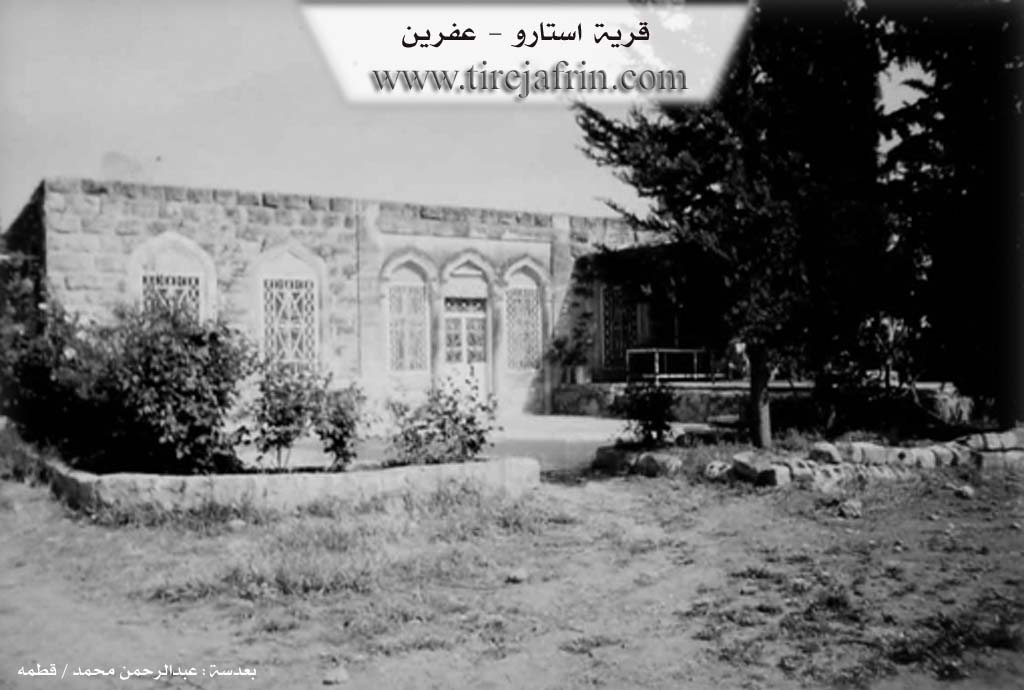
Photos
Basic Information about Astêr
Source: Khalil Sino
Etymology: Derived from the name of an ancient figure named Astar or an ancient sword known as Stêrk
Foundation Date/Period: 150 to 200 years ago
Hills: Gir
Trees: Tûya Mezin
Other Landmarks: Nahr al Aswad
Summaries
I. Summary from TirejAfrin Site (English) of Astêr
Source: https://www.tirejafrin.com/site/kura%20afrin%20markaz-astero.htm
The following details regarding Astr, Astaro, or El-Mestûre (Altitude 305m / Distance 8km) were found in the book Çiyayê Kurmênc (Efrîn): A Geographical Study by Dr. Mihemed Ebdo Elî:
"Astar" in Kurdish means "the lining" or "the lining of a thing" (betane), and we do not know the source of this name or the reason for this naming.
It is a small village located on a small rise that slopes eastward toward the Efrîn river. Beside it is the Istasyona Qurt Qulaq (Qurt Qulaq station) for the train. It is a modern village dating from the 1950s, and it was formerly the property of Zekî Axa Şêx Îsmaîl Zade.
According to the book Efrîn... Her River and Her Green Hills by the writer Ebdulrehman Mihemed from the village of Qetme:
Astaro is a village in Çiyayê Kurmênc, administratively belonging to the central Efrîn sub-district in the governorate of Heleb. It is a small village situated on a plateau and on undulating alluvial land that slopes eastward toward the Efrîn river. It is located to the northeast of the village of Xezra / Cûyêq. It was formerly attached to the village of Cûyêq.
The village is bordered to the north by a fertile agricultural plain planted with olive trees and pomegranate orchards, the Istasyona Trêna Efrînê (Efrîn train station), and the village of Kefer Rûm. To the south, it is bordered by a slope and a fertile agricultural plain with two valleys where water flows into the valley of the Efrîn river, specifically the Avên Zerafik (Zerafik waters), which spring from the village of Baedînlî, the village of Tel Tewîl, and the city of Efrîn. To the east, there is a slope, the valley of the Efrîn river, a mountainous rise, and the village of Qestel Kişk. To the west, there is a wide fertile plain planted with grains and olive trees, the farm of Mezreya Eyn Dîbe which is empty of inhabitants, the Riya Efrîn-Reco (Efrîn-Reco road), the village of Cûyêq, and Eyn El-Hecer El-Kebîr.
The number of houses reaches about 40, and the age of the village is approximately 125 years. It was formerly a single house, consisting of a villa belonging to the family of Behcet Şêx Îsmaîl Zade and Zekî Reşîd Şêx Îsmaîl Zade. Its modern houses are made of stone and cement. The electricity network is available, and there is a primary school located in the north of the village. Residents drink water from artesian wells located inside the courtyards.
The area connects to a paved road that passes near it, up to the Istasyona Trêna Efrînê (Efrîn train station) north of the village at a distance of 2km. Its inhabitants work in agriculture, especially the cultivation of olives and grains, and the cultivation of orchards such as pomegranates and vegetables irrigated from the Efrîn river or from artesian wells found in the lands, alongside raising sheep and goats. It is a village with fertile agricultural lands due to its proximity to the river. Among its most important families are the family of Şêx Îsmaîl Zade and Behcet Zekî Axa.
Sources
Book: جبل الكرد (عفرين) دراسة جغرافية Çiyayê Kurmênc (Efrîn): A Geographical Study by د. محمد عبدو علي Dr. Mihemed Ebdo Elî.
Book: عفرين .... نهرها وروابيها الخضراء Efrîn... Her River and Her Green Hills by عبدالرحمن محمد Ebdulrehman Mihemed from the village of Qetme.
Preparation and execution: Manager of Navenda Tirej Efrîn website / Ebdulrehman Hacî Osman.
20/12/2013
II. Summary of Astêr from Khalil Sino
Source: https://www.youtube.com/watch?v=vYl9oEslWN8
The village of Stêr, also referred to as Stêrk, is a historic settlement located in the Efrîn region of Çiyayê Kurmênc. According to local oral history, the village was established in its current location approximately 150 to 200 years ago. An elder named Bêrem recounts that the original settlement was situated on a hilltop known simply as the Gir. The residents eventually descended from this high ground to the plain below to establish the modern village. The etymology of Stêr is the subject of local legend; one account suggests the name evolved from Astar, an ancient figure who may have been Armenian, Christian, or Muslim. Another elder proposes that Stêrk refers to a type of ancient sword.
The social structure of Stêr is defined by a deep history of intercommunal living. The village foundation story states that it was settled by four Kurmanc households and four Arab households. These families lived together with a profound sense of unity, sharing their weddings, resolving conflicts together, and working the land as brothers. The residents emphasize that there has never been a distinction between the Kurmanc and Arab inhabitants, as they share the same water and soil. Notable contemporary figures mentioned include the village head Zekeriya Alan and the composer Xalid Mistikal.
Geographically, Stêr is situated roughly one to six kilometers from the city of Efrîn, depending on the route taken. A significant natural landmark near the village is the Nahr al Aswad, or the Black River, though residents note that it has largely dried up in recent years. Within the village itself stands the Tûya Mezin, a massive and ancient mulberry tree that serves as a central gathering point. Due to the geography, water is difficult to access, with wells in the village reaching depths of 250 to 400 meters. The village economy relies on rain fed agriculture, producing wheat, barley, and lentils, as well as livestock farming. The community also houses a mosque and a school, the latter of which was renovated by a charitable organization.
II. Summary of Astêr from Ax û Welat
Source: https://www.youtube.com/watch?v=L7a96PT2ook
The village of Stêr is located in the Mabata district, about five kilometers north of the center of Efrîn. It is situated on the banks of Çemê Efrînê and is known for its abundant water sources, rich agriculture, and harmonious coexistence of Kurdish and Arab populations.
The original settlement of the villagers was previously located several kilometers north at Qilbê Mehetê, situated below the area known as Xirabê Lo. Nearly a century ago, a prominent local figure named Kur Reşîd relocated to the current site of Stêr due to its elevated environment and proximity to springs and the river. He built a large guesthouse there, and the local farmers soon followed him. Initially founded by about five families, the community grew as others arrived from various neighboring villages, including Qestelê, Me'milê, Gêçiya, Gemrûkê, Kaniyê, and the city of Efrîn. Today, the largest family lineage traces its roots back to Me'milê.
The village has a deeply intertwined history of Kurds and Arabs living together. Arab families arrived shortly after the initial Kurdish settlement, and the two communities grew up together, sharing daily life, language, and culture. Almost all the Arab residents speak fluent Kurmanji Kurdish. During the era of the Baath regime in Syria, the government enacted the Agrarian Reform Law, confiscating lands from major landowners and distributing them in an attempt to engineer demographic changes in the region. However, the strong solidarity and unity between the Kurdish and Arab residents of Stêr thwarted the divisive political aims of the regime.
Endowed with rich red soil and abundant water, Stêr is highly productive. Historically, locals practiced shepherding, but a man named Ehmed Cebelî from Emîrût introduced cotton farming to the area. Today, the village cultivates multiple crops a year, including potatoes, onions, wheat, barley, lentils, and a wide variety of vegetables and fruits like apples and pears. The village is self sustaining, with most residents working their own lands rather than seeking employment in cities like Efrîn or Heleb.
The village features striking Ottoman style houses built from black stone. The surrounding area is dotted with historic watermills powered by the local springs, with notable sites including the century old mills known as Aşê Çoqê and Aşê Corc.
Transcriptions and Subtitles
| Source | Video | Subtitles | Transcript |
|---|---|---|---|
| Ax û Welat 1 | Watch Video | Download SRT | View Transcript |
| Khalil Sino 1 | Watch Video | Download SRT | View Transcript |
Foundation/Origin Information of Astêr
Was among the properties of Zaki Agha Sheikh Ismail Zadeh. Was previously one house consisting of a villa belonging to the family of Bahjat Sheikh Ismail Zadeh and Zaki Rashid Sheikh Ismail Zadeh.
Source: TirejAfrin Site
It was originally established as a feudal estate belonging to the Sheikh Ismail Zadeh family, with a central mansion, or "konak," for the Agha named Zaki Agha. The village's story begins at an old mulberry tree that served as a resting place for the early inhabitants, who were a mix of Arabs, Kurds, and Turkmen. The original village was located higher on a limestone hill but was later relocated to a lower area after the Agha requested the villagers move, selling them new plots of land. The community grew through intermarriage, particularly after the arrival of Arab families from the Ajami tribes.
Source: Other Channels
Possible Village Name Meaning of Astêr
"Astar" in Kurdish means "the lining - lining of something", and we do not know the source of this name or the reason for this naming.
Source: TirejAfrin Site
V. Links
- Tirej Afrin:
https://www.tirejafrin.com/site/kura%20afrin%20markaz-astero.htm - Ax û Welat:
https://www.youtube.com/watch?v=L7a96PT2ook - Jawlat:
https://www.youtube.com/watch?v=h9oWwI74heA - Video:
https://www.youtube.com/watch?v=H7xCtQqSX3s - Link:
https://www.youtube.com/watch?v=wzVZvyqXrME - Link:
https://www.youtube.com/watch?v=teY2Z9oCUlo - Link:
https://www.youtube.com/watch?v=iXXNVYIqyDs - Khalil Sino:
https://www.youtube.com/watch?v=vYl9oEslWN8