General Information
Nahiya (Subdistrict)
Cindires
Also Known As
Celeme, Celemê, Cêlemê, Galamo, Jelamê, Jiqallali Joum, جلمه
Families, Clans, etc.
Al Kenc, Erebo, Malê Betalê Betêl, Malê Cimo, Malê Ebû Na'me, Malê El-Xazêl, Malê Emrî, Malê Ewê, Malê Gedel, Malê Hemoyê Reşo, Malê Koso, Malê Kêlxelo, Malê Mihemed Eyûb, Malê Qereqo Celkî, Malê Sêwê, Malê Zekî axa, Malê Şêxîn Ebû, Mistefa, Wehîd Axa

Photos
Basic Information about Celemê
Source: Ax û Welat
Etymology: Derived from "Cî" (place) and "Lêm" (sound of rushing water), meaning the place of rushing water
Foundation Date/Period: Mitanni and Hurrian eras; destroyed by earthquake in 528 AD
Caves: Şikefta Dîbsiz, Şikefta Bûyê
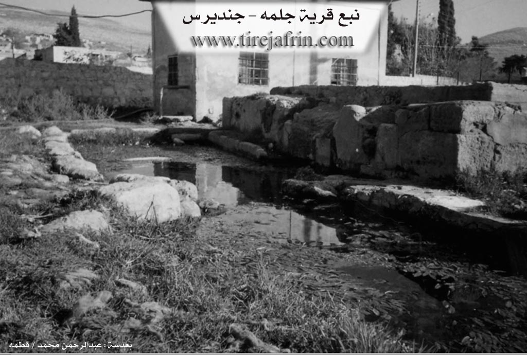
Springs: Kaniya gund, Kaniya Tirba, Kaniya Mercanê, Kaniya Hemşerewî, Kaniya Gulistanê
Hills: Girê Admar, Çiyayê Îbiş, Gulxilo, Mîta Mehsere, Mîta Şehbû
Shrines: Şêx Teyar, Şêx Mûs
Ruins: Celemê kevn, Gelîyê Mirtiba, Kêşik
Wells: Bîra Sor, Bîra Kevzê
Other Landmarks: Çiyayê Lêlûn, Deşta Cûmê, Çetê Werdê, Çemê Efrînê
Summaries
I. Summary from TirejAfrin Site (English) of Celemê
Source: https://www.tirejafrin.com/site/kura%20afrin%20Cindires%20-%20celeme.htm
The following is stated in the book جبل الكرد (عفرين) دراسة جغرافية Çiyayê Kurmênc (Efrîn): A Geographical Study by د. محمد عبدو علي Dr. Mihemed Ebdo Elî regarding Celem:
Henry Lammens says about it that it is the Crusader village of Galamo located in the Diocese of Antioch. We do not know the meaning of its name.
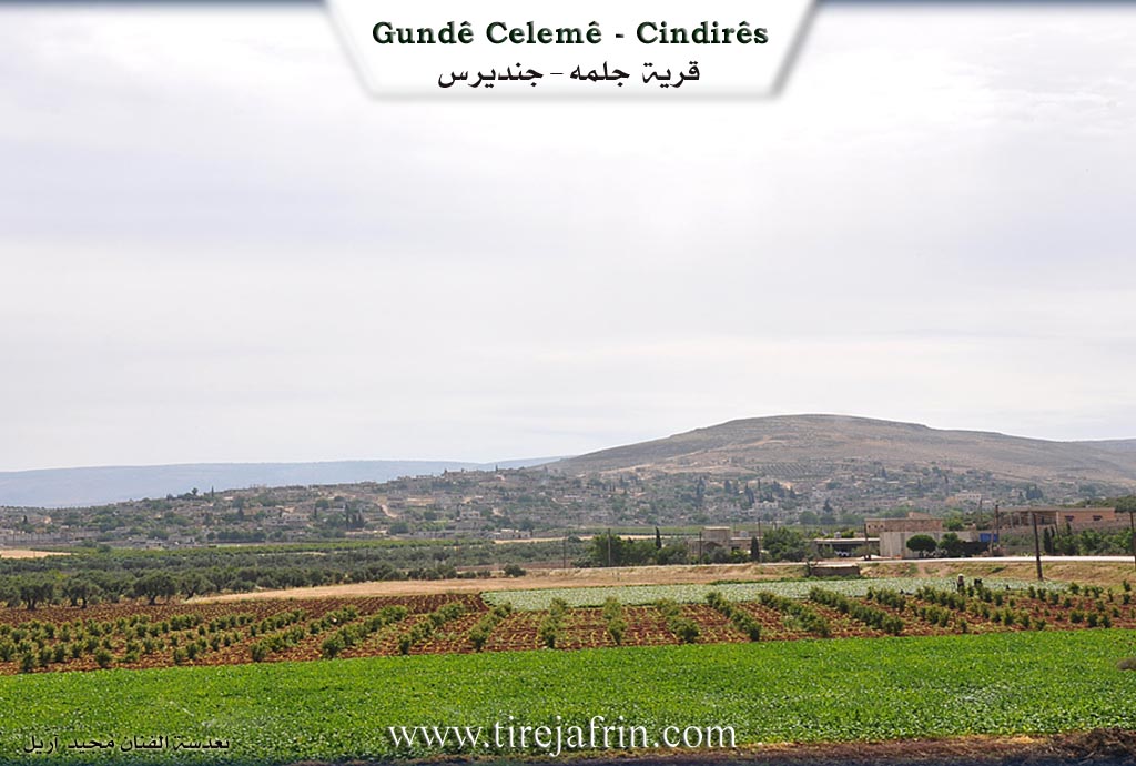
It is a large village located on the western slope of a plateau adjacent to Çiyayê Lêlûn. It is characterized by tobacco cultivation, and there are numerous ovens for drying it. There are two springs in the village: the first is in the south with a flow of 8 liters/second, and the second is north of the village. There is an archeological mound (Tel) in the north of the village. Celem was one of the villages of the Al Kenc family in Deşta Cûmê before they left for Turkey in the fifth decade of the twentieth century.
The following is stated in the book عفرين .... نهرها وروابيها الخضراء Efrîn... Her River and Her Green Hills by the writer عبدالرحمن محمد Ebdulrehman Mihemed from the village of Qetme, Çeqelî Cûm:
It is a village in the plain of the Efrîn valley (Deşta Cûmê), administratively following the Cindirês district, Efrîn region, Aleppo governorate. It is very large, located near the western and northern slopes of Çiyayê Seman. Its soil is fertile alluvium due to the abundance of springs that flow from its lands.
It is bordered to the north by a fertile plain planted with pomegranate trees, the Çemê Efrînê (river), the village of Frêriyê, and Ebû Keib West. To the south, it is bordered by a rugged mountain range of the nearby Çiyayê Seman, Ziyareta Şêx Berekat, and Daret Ize. To the west lies a plain fertile for agriculture planted with pomegranate trees, the farm of Feylek, Xirbe Elûş, and Tel Selûr. To the east are mountain heights, the Qarsaq farm, and the village of Iskan.
The number of its houses reaches about 500, and its age is about 500 years. Its old houses are stone and mud with flat wooden roofs, while the majority are modern concrete spreading towards the northwest. A electricity network, a primary school, a preparatory school, and a mosque in the center of the village are available. A municipality hall was established in 1999, as well as an agricultural extension unit, a peasant cooperative society, and a telephone center. The village drinks from a network that draws its water from springs whose flow is estimated at 3 liters/second.
There are about 25 buildings for tobacco fermentation equipped with heating and featuring dual-slope roofs. Its residents work in rainfed agriculture on an area of 1425 hectares with grains, olive trees, and tobacco. They cultivate 470 hectares via irrigation from artesian wells and a spring in its south with tobacco, vegetables, pomegranate trees, apricots, and walnuts. A section of them works in fermenting rainfed tobacco (Virginian) and irrigated tobacco (Burley), alongside raising sheep, cows, and goats.
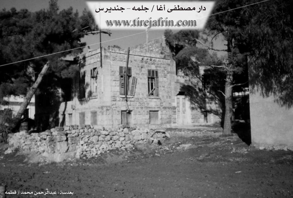
The settlement of the area is very ancient, indicated by the remains of archeological places within it. The village of Celem is considered one of the large and old villages in Deşta Cûmê, the Cindirês district, and the Efrîn region. There are several old houses in the form of luxurious villas belonging to the family of Mistefa and Wehîd Axa, who were the first to inhabit the village and are the original inhabitants. Three farms are dependencies of the village: Ebû Keib East, Ebû Keib West, and Hacîler.
An asphalt road connects it to the town of Cindirês, and currently, there is a main street in the center of the village established by the municipality of Celem.
Village Mukhtar: Mihemed Erebo
Sources
Book: جبل الكرد (عفرين) دراسة جغرافية Çiyayê Kurmênc (Efrîn): A Geographical Study by د. محمد عبدو علي Dr. Mihemed Ebdo Elî.
Book: عفرين .... نهرها وروابيها الخضراء Efrîn... Her River and Her Green Hills by عبدالرحمن محمد Ebdulrehman Mihemed from the village of Qetme, Çeqelî Cûm.
Preparation and Execution:
Manager of Tîrêj Efrîn website: Ebdulrehman Hacî Osman
20/12/2013
II. Summary of Celemê from Ax û Welat
Source: https://www.youtube.com/watch?v=E8vpDQO72o4
The village of Celemê, located in the Cindirês district of the Afrin region, sits at the foot of Çiyayê Lêlûn overlooking the vast Deşta Cûmê. The village name is said to derive from the Kurmanji words "Cî" (place) and "Lêm" (the sound of rushing water), referencing the abundance of water sources in its history. The settlement is home to a diverse population of approximately 5,000 people, comprising three communities: Kurds, Arabs, and Turkmens.
The history of Celemê is bifurcated into two distinct sites: the current village and an ancient site known as Celemê kevn (or Eski Celemê), located about three kilometers away in the mountains. This ancient site dates back to the Mîtanî and Hûrî empires, evidenced by archaeological remnants such as bull head carvings and rock-cut tombs. A catastrophic earthquake in 528 AD, which also destroyed the nearby Keleha Semanê, devastated the original settlement. For generations, the old site served as a seasonal residence for families such as Malê Koso, Malê Cimo, and Malê Ewê, who would graze their livestock there before moving to the lower village. The ancient area features significant landmarks, including Şikefta Dîbsiz (a cave 40 meters wide), Şikefta Bûyê, and two historical wells known as Bîra Sor and Bîra Kevzê.
Socially, Celemê is defined by specific longstanding families rather than broad tribal confederations. The Kêlxelo family is identified as Turkman, while Malê Emrî (also known as Malê Ebû Na'me) is an Arab family. The majority of the village is Kurdish, including families such as Malê Gedel, Malê Hemoyê Reşo, Malê Sêwê, Malê El-Xazêl, Malê Şêxîn Ebû, and Malê Qereqo Celkî. Historically, the village was under the influence of local aghas (lords) like Malê Betalê Betêl and later Malê Zekî axa, who maintained properties in the area. A unique example of the village's intercommunal nature is Kulfet, a healer from the Malê Mihemed Eyûb family who treats the skin condition Mêristan.
The village is renowned for its agriculture, particularly tobacco (titûn) farming, which follows a strict cycle from planting in January to harvesting in late summer. Residents also cultivate olives, pomegranates, and fruits on the fertile plains of Deşta Cûmê. The village geography is marked by Çemê Efrînê to the west and hills like Girê Admar, Çiyayê Îbiş, and Gulxilo. Water sources are central to village life, with notable springs including Kaniya Hemşerewî, Kaniya Gulistanê, and Kaniya Mercanê. Religious observances are centered around local shrines such as Şêx Teyar and Şêx Mûs.
II. Summary of Celemê from Ax û Welat 2
Source: https://www.youtube.com/watch?v=Y3EPikudgZ0
The documentary provides a detailed look at the agricultural life of Jelemê (also referred to as Celemê by some residents), a village located in the Çiyayê Kurmênc region of Efrîn. While the transcript does not provide specific data regarding the village's founding date, etymology, or resident tribal structures, it establishes Jelemê as a central hub in a massive pomegranate producing belt.
The economy and daily life of Jelemê revolve entirely around the cultivation of pomegranates (hinar). Speakers describe a fertile corridor stretching from Dêr Belût in the west to Dêr Siwanê, encompassing villages such as Îskê, Xezawiyê, Şadêrê, Bircê, Basûtê, and Kurzêlê. One resident estimates there are approximately five million pomegranate trees across this region. Unlike other parts of Efrîn famous for olives, the "ardê sor" (red soil) of Jelemê is prized specifically for producing high quality pomegranates.
The villagers detail their agricultural techniques with precision. Trees are propagated using cuttings ("sing") rather than seedlings and can remain productive for up to fifty years. Irrigation is a critical concern; farmers utilize wells ("bîr") and have historically alternated between traditional channel irrigation ("cerî") and modern drip systems ("tenqîd"), though high fuel costs often force a return to flood irrigation. The harvest involves the entire family, including children named Ebdû and Ciwan, who work from early morning until the afternoon.
Several varieties of pomegranate are cultivated in Jelemê. These include Lefanî şîrîn (sweet), Lefanî tirş (sour sweet), and a variety known locally as Fransî (French) or "hinarê sor" (red pomegranate). The produce is processed into molasses ("dimsê hinarê") or sold fresh in markets in Efrîn and Heleb, with exports reaching Iraq, Libnan, Urdin, and Tirkiyê.
The transcript concludes with a cultural interlude rather than a historical account. A guest performs a traditional song about Alî Beg, referencing the "qesra rengîn" (colorful palace) and the "birca belek" (motley tower). This song laments the scattering of the Kurd people and invokes the memory of historical leadership, adding a layer of oral heritage to the otherwise technical discussion of agriculture in Jelemê.
II. Summary of Celemê from Ax û Welat 3
Source: https://www.youtube.com/watch?v=q_bznq2CGO4
The village of Celemê is situated in the fertile region of Efrîn within the broader area known as Çiyayê Kurmênc. Geographically, it is located in very close proximity to the city of Efrîn itself, lying only about three kilometers away. It is a substantial settlement containing approximately eight hundred households. The primary identity of Celemê is defined almost exclusively by its agricultural output, specifically the cultivation of titûn or tobacco. The entire village participates in this industry, which serves as the economic backbone for the local population.
According to a village elder named Ebrehmanê Nebî Silo, also addressed as Mam Hecî, the history of tobacco farming in Celemê has a distinct starting point. He recounts that in 1974, the government approached the villagers to encourage production. The state provided licenses known as ruxset and the necessary seeds, effectively transforming the village into a specialized farming community. Ebrehmanê Nebî Silo notes that in the past, they cultivated a variety called firne, which involved a fire curing process. However, that method has been abandoned, and the village now exclusively grows the Bêrli variety of tobacco.
The agricultural cycle in Celemê is rigorous and involves the entire family unit. Work often begins as early as 3:00 AM. Farmers plant seeds in a nursery or meştel during the winter months. Once the seedlings mature after about two months, they are transplanted into the fields. The crop requires regular irrigation every ten to fifteen days. During the harvest, laborers, including women and children like the young student Hemûde, work to break off the leaves. These leaves are then threaded onto strings using a large needle called a şûjin and hung to dry for approximately twenty days. A critical part of the process relies on the Xerbî, a specific humid westerly wind that softens the dry leaves, allowing them to be packed without crumbling.
The economic life of the village revolves around the relationship with the Rêjîya Heleb, the tobacco monopoly in Aleppo. After the tobacco is dried and cured, it is pressed into bales known as boliyan or qelib, which typically weigh between thirty five and fifty kilograms. The government supplies the burlap sacks for packing, though the cost is later deducted from the farmers' earnings. While the official price per kilogram has increased over time, rising from ninety six to one hundred and twenty Syrian pounds at the time of filming, the farmers note that their product is usually classified as medium quality or weset rather than premium. Despite the arduous nature of the work, the residents of Celemê continue this tradition as their primary means of livelihood.
Transcriptions and Subtitles
| Source | Video | Subtitles | Transcript |
|---|---|---|---|
| Ax û Welat 1 | Watch Video | Download SRT | View Transcript |
| Ax û Welat 2 | Watch Video | Download SRT | View Transcript |
| Ax û Welat 3 | Watch Video | Download SRT | View Transcript |
Foundation/Origin Information of Celemê
Considered one of the large and old villages in the Joum Plain. The first inhabitants were the family of Mustafa and Wahid Agha.
Source: TirejAfrin Site
Possible Village Name Meaning of Celemê
Henry Lammens says it is the Christian village Galamo, located in the Antioch parish. The meaning of its name is unknown.
Source: TirejAfrin Site