General Information
Nahiya (Subdistrict)
Şera
Also Known As
Botan, Diraqiliya, Diraqliya, Dirqiliyê, Duragli, Duraq, Durqliya, Dûrka, Dûrê, دوراق, دوراقلي
Families, Clans, etc.
Mala Cînciq, Mala Ebo, Mala Ereb, Mala Hesu, Mala Mêmkê, Mala Qulîka, Mala Qêsim, Mala Çîçekle

Photos
Basic Information about Diraqliya
Source: Ax û Welat
Etymology: Derived from the Turkish word "Duraqli" meaning a stopping place or station, or potentially from a Greek word meaning bravery
Caves: Şikeftê Mala Kordê
Springs: Kanî
Shrines: Taka Reş, Ziyareta Qereqoçê
Ruins: Gelî Xirabe, Berîsank
Trees: Taka Reş
Wells: Bîra Qereqoçê, Bîra Tûyê, Bîra Şadiyê
Other Landmarks: Ava Efrînê, Geliyê Qereqoje, Şaşorkê, Geliyê Qonê, Çinare
Summaries
I. Summary from TirejAfrin Site (English) of Diraqliya
Source: https://www.tirejafrin.com/site/kura%20afrin%20%20sheran%20-%20Diraqliya.htm
As stated in the book جبل الكرد (عفرين) دراسة جغرافية Çiyayê Kurmênc (Efrîn): A Geographical Study: Diraqliya, Duraqlî, Duraq /1166 people, 620 hectares, 15km, 490m/:
Deraq: In Kurdish, it means "situation or state", and the name might be derived from it. Duraq: Linguistically in Turkish, it means "the stop" or stopping place. As for the Arabized name, it is a verbal distortion of the old name.
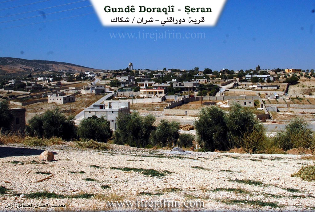
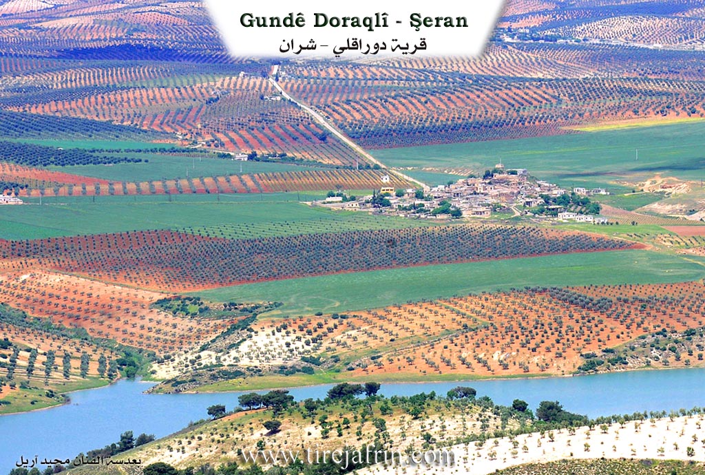
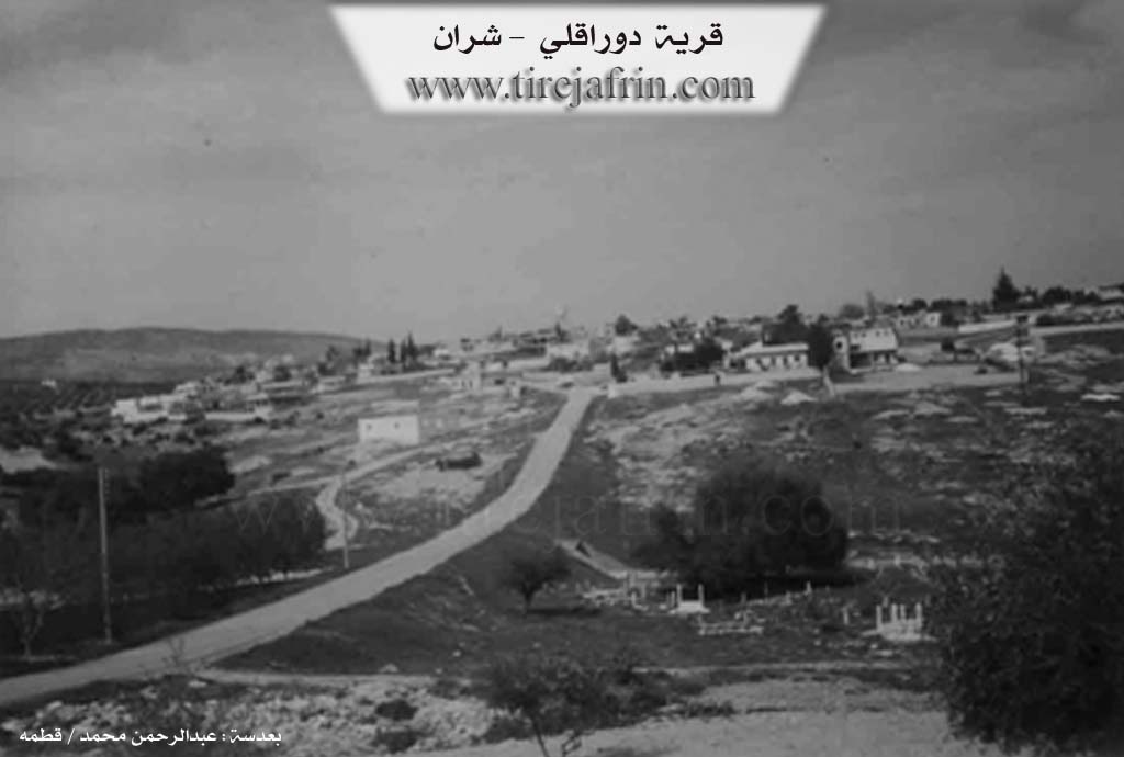
As stated in the book عفرين .... نهرها وروابيها الخضراء Efrîn... Her River and Her Green Hills: Duraqlî is a village in Çiyayê Kurmênc that follows the Şeran sub district, Efrîn district, Heleb governorate (1146 people). It is a large village located in the northern part of Çiyayê Kurmênc, atop a low limestone plateau that slopes slowly toward the southeast in the direction of the Efrîn valley. Its soil is clay like. It is located 15 km from the town of Şeran in the northwest direction.
It is bordered to the north by a wide plain of olive trees, a valley, and the village of Se'rincik; to the south by a slope, a valley, a plain planted with olive trees and grains, and the village of Elîcê; to the east by a valley, a plain of olive trees and grains, and the village of Zeytûnak; and to the west by a valley, a slope, a mountain chain, and the village of Qizilbaş and Bîlan Koy.
The number of its houses is approximately 75 houses and its age is approximately 400 years. Its old residences are made of stone and mud with wooden ceilings, while the modern ones are made of stones and reinforced concrete. An electricity network is available in it, and it contains a primary school. The village drinks from a connected water network drilled in its southeast.
Its residents work in the cultivation of olives, grains, and summer vegetables on an area of 1100 hectares of rainfed land. There is an olive press in the village. It is one of the beautiful and sweet villages in the region due to the beauty of its houses. It is connected to the sub district center by a paved road.
Village Mukhtar: Wehîd Şêxo Mihemed
Sources of Information:
- Book: جبل الكرد (عفرين) دراسة جغرافية Çiyayê Kurmênc (Efrîn): A Geographical Study by د. محمد عبدو علي Dr. Mihemed Ebdo Elî.
- Book: عفرين .... نهرها وروابيها الخضراء Efrîn... Her River and Her Green Hills by عبدالرحمن محمد Ebdulrehman Mihemed from the village of Qetme.
- Studies of Navenda Tirej Soft / Ebdulrehman Hacî Osman
- Some residents of the villages.
Preparation and execution: Manager of the Tirej Efrîn website: Ebdulrehman Hacî Osman 20/12/2013
II. Summary of Diraqliya from Ax û Welat
Source: https://www.youtube.com/watch?v=IGKR7PZ0VDA
The documentary takes place in the village of Diriqliya in the Çiyayê Kurmênc (Afrin) region. Unlike typical historical accounts involving ancient lineages or ruins, the current narrative of Diriqliya focuses on modern industrial development and its economic centrality to the surrounding area. The village is home to a newly established, technologically advanced flour mill (aş) that serves as a focal point for local employment and regional food security.
The facility is managed by Şaban, who oversees a team of approximately 15 workers operating in 12-hour shifts to keep the mill running 24 hours a day. The mill has recently entered its production phase, currently processing about 40 tons of wheat, with plans to expand capacity by another 15 tons. The workforce connects Diriqliya to the broader region; for instance, a worker named Mehmûd identifies himself as a resident of the neighboring village of Qerqîna.
The social and physical structure of the village described in this account is defined by this multi-story industrial building. Mistefa, a technical lead, describes the vertical organization of the mill, referring to the different floors as "daq" (e.g., daqê sê, daqê du). The process involves sophisticated machinery for cleaning wheat, removing stones and metal via magnetic separators, and separating the product into fine flour, semolina (simîd), and bran (kepek). The distinct lack of mentioning ancient landmarks or shrines suggests the village's current reputation is heavily tied to this modern utility.
The reach of Diriqliya extends significantly across the Efrîn region. A customer interviewed at the site is a baker from Gundê Hisê, located roughly 35 kilometers away. He travels to Diriqliya to purchase four tons of flour daily, citing the superior cleanliness and quality of the product compared to other sources. The documentary concludes with a musical performance celebrating the Efrînî identity, referencing the region's agricultural abundance—specifically vineyards, figs, apples, and pomegranates—though these are lyrical tributes to the region rather than specific geographic features of the village itself.
II. Summary of Diraqliya from Ax û Welat 2
Source: https://www.youtube.com/watch?v=Lz-343TNf-4
The village of Duraqliya, located in the Şera district of Efrîn, holds a strategic and historical position between the ancient sites of Keleha Sem‘anê and Keleha Hûrî. According to local elders like Fewzî, the village’s name likely stems from the Turkish word "Duraqli," functioning as a "stopping place" or station where travelers on the historical Silk Road would rest near water sources before continuing to Kilis. Others suggest a Greek origin for the name, implying "bravery." In the 1990s, during the rise of the Kurdish Freedom Movement, the village acquired the name Botan among locals due to its strong political engagement and the presence of cadres who established camps there.
The settlement history of Duraqliya begins with the migration of families from a nearby location known as Gelî Xirabe. Originally, these ancestors lived in caves known as Şikeftê Mala Kordê. The first settler to establish a house at the current village site was Îbrahîmê Cinciq, the patriarch of the Mala Cînciq family, who moved down to access better water sources and agricultural land. Today, the village is home to approximately 140 households comprising several distinct families. The largest families include Mala Cînciq, Mala Hesu, and Mala Qulîka, alongside smaller lineages such as Mala Mêmkê, Mala Qêsim, Mala Ebo, Mala Ereb, and Mala Çîçekle. The community is described as cohesive, with frequent intermarriage creating strong bonds between these groups.
The landscape around Duraqliya is defined by the Ava Efrînê (Afrin River), which flows through the nearby Deşta Berîsankê. The village was historically rich in water sources, utilizing wells like Bîra Tûyê, Bîra Şadiyê, and Bîra Qereqoçê, though some have dried up or become saline. Spiritual life in the village centers around specific landmarks, most notably Taka Reş (also called Takê Reş), a sacred valonia oak tree. For generations, residents visited this tree, particularly on Fridays, to tie fabrics to its branches and seek healing for illnesses. Another sacred site, Ziyareta Qereqoçê, is located near the village cemetery and a well of the same name.
In modern history, Duraqliya is renowned for its role in education and infrastructure within Rojava. It was the site of the first Kurdish-language school in the region, Dibistana Şehîd Fewzî, established on September 6, 2011, by teachers like Dicle and Mehmûd in the private home of a resident named Pîr Beşîr. Additionally, the village hosts a major industrial facility, Aşê Rûken, a large flour mill founded by Rûken and Fîraz Şêxo in 2013 to address bread shortages in the canton during the Syrian civil war.
Transcriptions and Subtitles
| Source | Video | Subtitles | Transcript |
|---|---|---|---|
| Ax û Welat 1 | Watch Video | Download SRT | View Transcript |
| Ax û Welat 2 | Watch Video | Download SRT | View Transcript |
Foundation/Origin Information of Diraqliya
founded by ancestors who migrated from the Cizîra Botan region.
Source: Halil Sino Transcript
Possible Village Name Meaning of Diraqliya
Deraq: In Kurdish means "situation or condition". Duraq: In Turkish means "the stop", or stopping place.
Source: TirejAfrin Site
formerly known as Dûrka due to its distance from Afrin.
Source: Halil Sino Transcript