General Information
Nahiya (Subdistrict)
Reco
Also Known As
Alamdar, Alandarê, Alendarê, Elemdara, Elemdarê, Elemdêr, Elendara, علمدار, علمداره
Tribes
Alemdar
Families, Clans, etc.
Hec Reşîd, Hecî Elemdêr, Mehmedko, Meho, Mihemed, Mihemedko, Nasan, Qanqilê, Xecikê

Photos
Basic Information about Elendara
Source: Ax û Welat
Etymology: Named after the Alemdar tribe; the name means standard bearer or owner of the flag
Foundation Date/Period: Around 1600 AD
Caves: Şikefta Alemdêr
Springs: Kaniya gewre, Qestel
Hills: Çiyayê Bilêl, Biladê Hebeş, Çiyayê Çirq
Shrines: Sehba ye Bilalê Hebeş
Other Landmarks: Geliye Cirqa, Tehta Hîrê, Deşta Cmiyê, Cihê Bilîl, Çemê Aqûbê, Çemê Kereng, Deşta Hamqê
Summaries
I. Summary from TirejAfrin Site (English) of Elendara
Source: https://www.tirejafrin.com/site/kura%20afrin%20%20%20Reco%20-%20Elendara.htm
It is stated in the book جبل الكرد (عفرين) دراسة جغرافية Çiyayê Kurmênc (Efrîn): A Geographical Study by د. محمد عبدو علي Dr. Mihemed Ebdo Elî:
Elendara / Elemdar
Population: 810.
Elevation: 433m.
Distance: 10km.
Origin of the name: 'El Dar. Elî was the first inhabitant of the site; he had placed his tent beside a large cypress tree, so he was called "Elî the owner of the tree" or "the arboreal one." He also established a place for sitting upon the branches of that large tree.
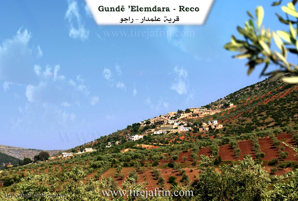
It is a small village located on the northeastern slope of Çiyayê Bilêl. It is the village of the Mujahid Resûl Reşîd, whom the French Mandate forces executed.
It is stated in the book عفرين .... نهرها وروابيها الخضراء Efrîn... Her River and Her Green Hills by the writer عبدالرحمن محمد Ebdulrehman Mihemed from the village of Qetme:
Elemdar: A village in Çiyayê Kurmênc following the Reco subdistrict, Efrîn region, Heleb governorate. It is a small village located in the northern part of the mentioned mountain, on the northern slope of a limestone highland that descends slightly towards the north. It overlooks agricultural lands with alluvial soil to the north. It is 7 km away from the town of Reco heading northeast.
It is bordered to the north by an agricultural plain, the Riya Bilbile-Reco (Bilbile-Reco road), and the village of Cîlanlî. It is bordered to the south by a high mountain range of oak and forest trees, and the villages of Zerkanlî and Çobanlî. To the west, it is bordered by a mountain range, a rugged valley, and the village of Çeqmaqê Biçûk. To the east, it is bordered by a slope, two watercourses, a rugged mountain range, and the village of Gurzêla Bilbile.
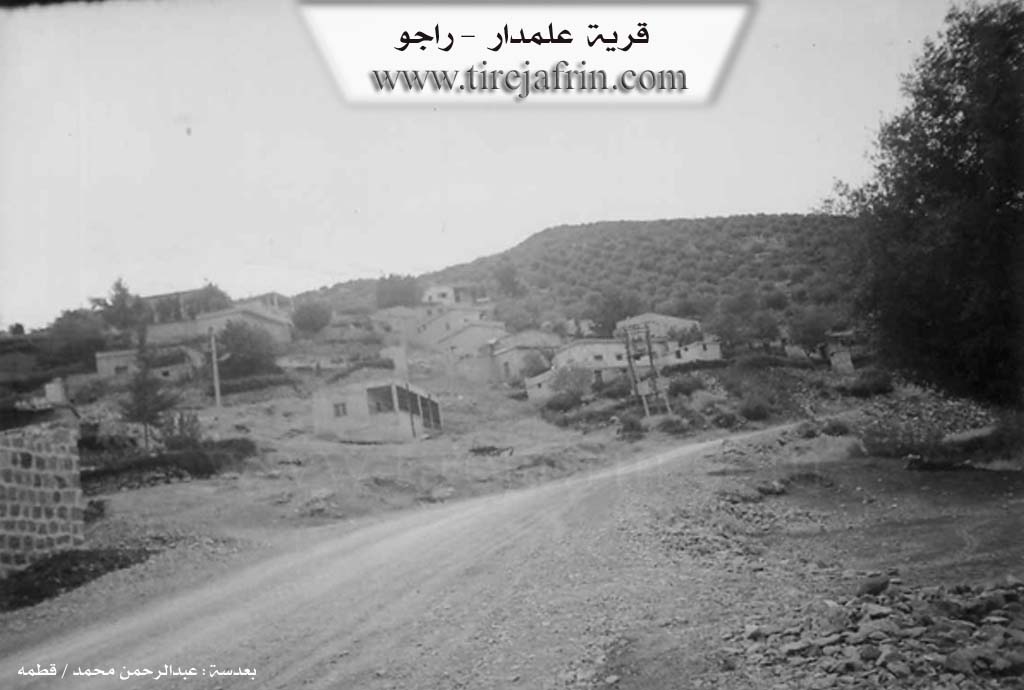
The number of its houses amounts to about 35 houses, and its age is about 250 years. Its old dwellings are made of stone and mud with wooden ceilings, while modern ones have spread on the sides of the village to the north and east. An electricity network and a modern primary school are available in it. The village drinks from rainwater collected in cisterns dug in front of the houses. Iron ores are also abundant in the rocks on the eastern side of the village, which is called in the country Hesinê Reco (Rajo iron). It connects to the subdistrict center via a dirt road up to the public road.
The residents work in rain fed agriculture on an area of 423 hectares (olives, vines, legumes, grains) and irrigated summer vegetables from artesian wells.
This village was named after Elî, who was the first to dwell in the area of the village among the trees. Since the word dar in the Kurdish language means "trees" in Arabic, the name of the village became Elî Dar, and then it transformed into Elemdar. Thus, Elî Dar is the founder of the current village.
Among the families of the village are Hec Reşîd (also known as Hecî Elemdêr) and Mihemed (also known as Mihemedko), and there are many university degree holders. It is mentioned that the teacher Şêx Mihemed Mihemed was among the first teachers in the Efrîn region.
Village Mukhtar: Mistefa Hecî Reşîd
Preparation and execution:
Manager of Tirej Efrîn website: Ebdulrehman Hacî Osman
20/12/2013
Sources:
Book: جبل الكرد (عفرين) دراسة جغرافية Çiyayê Kurmênc (Efrîn): A Geographical Study by د. محمد عبدو علي Dr. Mihemed Ebdo Elî.
Book: عفرين .... نهرها وروابيها الخضراء Efrîn... Her River and Her Green Hills by عبدالرحمن محمد Ebdulrehman Mihemed from the village of Qetme.
II. Summary of Elendara from Ax û Welat
Source: https://www.youtube.com/watch?v=Toeto-7asdM
The documentary highlights the village of Elem Dara which is situated in the Efrîn region specifically within the area known as Çiyayê Kurdagê. The narrative focuses on the village's deep connection to viticulture and the production of grape molasses known as dims. While the specific founding date of Elem Dara is not provided local elders share oral history regarding the technological evolution of their craft. In the past during the time of their ancestors the villagers processed grapes using a massive wooden log press called a Topan. This traditional method required a wooden screw mechanism known as a Megane or Kumik and the use of brushwood to filter the juice. This labor intensive wooden equipment has generally been replaced by iron machinery and metal screw presses referred to as Şede which allow for more efficient extraction.
The agricultural life of Elem Dara revolves around specific grape varieties including Du kilgan Şi'î Hêvîdî Ezêzî Helwanî Şamî and Qeysî. Among these Du kilgan is considered the highest quality for producing molasses followed by Hêvîdî and Şi'î. The production process is complex and utilizes specific infrastructure within the village. The grapes are pressed on a prepared surface called a Ferş and the juice flows into a collection tank known as a Jurn. To clarify the liquid villagers add a specific white soil known as Axa spî. The juice is then boiled in a cauldron called a Hile where foam and impurities are removed with a tool called a Kefgir until the molasses reaches a red and thick consistency.
Socially the harvest in Elem Dara is a communal event where families and neighbors assist one another in the vineyards. The economy of the village is tied to this seasonal production with the molasses packaged in large tins and sold to merchants. These merchants distribute the product throughout Efrîn and to external markets reinforcing the reputation of Elem Dara as a center for high quality grape products. Notable residents involved in the process include Şaro and Hecî who explain the technical details of the boiling and filtration methods used today.
II. Summary of Elendara from Ax û Welat 2
Source: https://www.youtube.com/watch?v=23GXWfMaCO4
The village of Alemdara, located in the Recû district of Afrin at the foot of Çiyayê Bilêl, possesses a migration history that spans several centuries. According to local oral tradition and historical accounts, the founders belonged to the Alemdar tribe from Bakurê Kurdistanê. Around the year 1600 AD, due to fragmentation and pressure during the Ottoman era, members of this tribe migrated first to Deşta Hamqê and subsequently entered the Çiyayê Kurmênc region. The ancestors, led by a figure named Ali, did not immediately settle at the current site. They first resided near Xerza by a large spring known as Kaniya gewre, where a cave named Şikefta Alemdêr still exists today. They later moved to Avrazê and then to Geliye Cirqa just east of the present village. Finding Geliye Cirqa to be too narrow and lacking in sunlight, they eventually established Alemdara on its current sunny and spacious slope.
The social structure of the village is defined by the descendants of the Alemdar tribe, primarily organized into the Hec Reşîd family, who trace their lineage back to Ali. Over time, other families such as Mehmedko, Nasan, and Meho joined the community. Some groups, such as the Qanqilê and Xecikê families, lived in the village for a period before relocating to other areas like Reco or Gemrûkê. Alemdara is particularly renowned for its long standing emphasis on education. Even in earlier times, villagers hired teachers from Kilis or sent their children away to study. This tradition produced significant figures like Dr. Reşîdê Resûl, an intellectual who resisted the French mandate and was executed in Bêrût, and Dr. Şêx Mihemed. In the modern era, the village honors fallen fighters such as Şehîd Şêrzad Hec Reşîd, whose home was converted into a school, as well as Şehîd Slav and Şehîd Avdar.
The landscape around Alemdara features notable natural and sacred landmarks. Çiyayê Bilêl, also referred to as Biladê Hebeş, towers over the area. A specific site known as Sehba ye Bilalê Hebeş serves as a sacred place where villagers historically offered sacrifices and prayed for rain. The agricultural lands include areas named Tehta Hîrê and Deşta Cmiyê. The village is historically famous for viticulture, maintaining approximately 40,000 grapevines. The production of grape molasses, known as dims, is a vital communal activity involving traditional presses. In recent years, residents have also developed greenhouse agriculture to grow cucumbers and peppers, aiming to secure local food supplies against economic isolation.
Transcriptions and Subtitles
| Source | Video | Subtitles | Transcript |
|---|---|---|---|
| Ax û Welat 1 | Watch Video | Download SRT | View Transcript |
| Ax û Welat 2 | Watch Video | Download SRT | View Transcript |
Foundation/Origin Information of Elendara
Ali Dar is the founder of the current village.
Source: TirejAfrin Site
The founding family, led by a man named Ali, settled the current village site. The lineage is traced from Ali to Hebeş, to Bilal, to Hec Reşîd. The Elemdar tribe came from North Kurdistan, was dispersed by the Ottomans, and settled in several locations before establishing the village.
Source: Ax û Walat Transcript
Possible Village Name Meaning of Elendara
The name originates from Elê Darê. Ali, the first resident, lived beside a large cypress tree (dar in Kurdish), so he was called "Ali, owner of the tree." The name became Ali Dar and later changed to Alamdar.
Source: TirejAfrin Site
The name originates from the Elemdar tribe (Eşîra Elemdar). In the local dialect, it is pronounced "Elemdêr."
Source: Ax û Walat Transcript