General Information
Nahiya (Subdistrict)
Reco
Also Known As
Al-Haidariya, Eltaniya, Eltaniyê, Ĝeyder, Ĥeyder, الحيدرية, حيدر اوبه سي, علطانيو, علطونيو
Tribes
Şêxiyan
Families, Clans, etc.
Ebdalo, Elî Saleh, Hecemo, Mala Beldînê, Mala Bilîlûtkê, Mala Guldînê, Mala Mistûko, Mala Pîrê Heyder, Mala Sêlix, Salih Nimir

Photos
Basic Information about Eltaniya
Source: Ax û Welat
Etymology: Named after the founder Elî, who had blue eyes; locals called him Altone (blue-eyed), which evolved into Altaniya
Foundation Date/Period: 1923
Springs: Kaniya Şîn
Hills: Çiyayê Çoxlo, Çiyayê Gawir, Sirta Se'bê, Tepê Keleçiqê, Biniya Qopê
Ruins: Xirabê Sêlkê
Other Landmarks: Geliyê Qurbetê, Geliyê Zîvî, Çemê Reş, Firfirê Kaniya Şîn
Source: Afrin 366
Hills: Qerebaba, Çiyayê Gewr
Other Landmarks: Deşta Tirkiyê, Deşta Sûrkê, Deşta Mîdan Mekbeze, Yûlçate, Xeraba ba
Summaries
I. Summary from TirejAfrin Site (English) of Eltaniya
Source: https://www.tirejafrin.com/site/kura%20afrin%20%20%20Reco%20-%20Eltaniya.htm
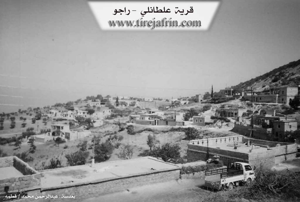
From the book جبل الكرد (عفرين) دراسة جغرافية Çiyayê Kurmênc (Efrîn): A Geographical Study: Gundê Heyder 'Eltaniya, Haydar Obasî, Al-Haydariya / 5km 870m /:
The village is known by two names. The first is the village of Heyder, with Heyder being a proper name. The second is 'Eltanî, which is derived from the proper name Elî and his nickname Tane, meaning the bull (Elî + Tane). This is a title of admiration that was given by the inhabitants of the village of Hopka to the first inhabitant of the site, whose name was Elî, due to his generosity and courage.
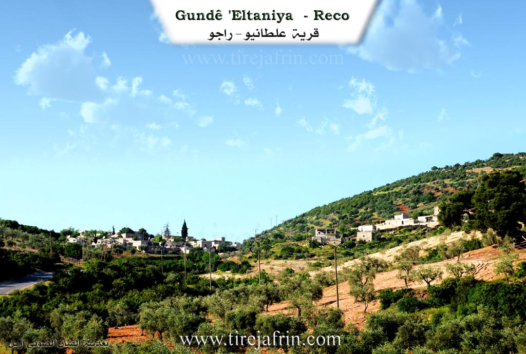
It is a small village located on the western slopes of the forested Bilalîko mountain.
From the book عفرين .... نهرها وروابيها الخضراء Efrîn... Her River and Her Green Hills: 'Eltanyo is a village in Çiyayê Kurmênc belonging to the Reco district, Efrîn area, Heleb governorate. It is a medium sized village located on the western slope of a limestone elevation covered with oak forests and pastures. Its soil is red. It is located 5 km towards the northwest of the village of Mamalî.
It was built in a defensive location. It is bordered on the north by a mountain slope, a deep stream, and the village of Ce'enkelî. It is bordered on the south by a slope, a stream, and the village of Mamalî. To the east, it is bordered by a high mountain range called the Bilalîko mountain, the village of Çeqmaqê Mezin, a stream, a very harsh slope, the antique Pira Heşrkê (Heşrkê bridge), and the Turkey border directly.
The number of its houses amounts to about 50 houses and its age is about 100 years. Its residences are stone and mud with wooden roofs, and modern concrete buildings have spread around the old core. An electricity network and a primary school are available in it. It connects with the district and neighboring villages via a paved road. The village drinks from cisterns in which rainwater collects in winter.
The residents work in rain fed agriculture on an area of 200 hectares, cultivating olives, vines, and some fruit trees on mountain terraces such as walnuts, cherries, and almonds, alongside raising sheep and goats. Among its most important families are: (Salih Nimir), who were the first to inhabit the village due to migration from the village of Etmanlî located south of Reco because of the occurrence of a problem that caused a blood feud between the Salih family and the mentioned village 100 years ago.
Village Mukhtar:
Sources of Information:
- Book: جبل الكرد (عفرين) دراسة جغرافية Çiyayê Kurmênc (Efrîn): A Geographical Study by د. محمد عبدو علي Dr. Mihemed Ebdo Elî.
- Book: عفرين .... نهرها وروابيها الخضراء Efrîn... Her River and Her Green Hills by عبدالرحمن محمد Ebdulrehman Mihemed from the village of Qetme.
- Studies of Navenda Tirej Soft / Ebdulrehman Hacî Osman.
- Some residents of the villages.
Preparation and execution: Manager of Tirej Efrîn website: Ebdulrehman Hacî Osman 20/12/2013
II. Summary of Eltaniya from Ax û Welat
Source: https://www.youtube.com/watch?v=fnTn8hIYvhQ
The village of Altaniya (also referred to as Altunya) is situated on the high elevations of Çiyayê Çoxlo in the Reco district of the Afrin region. The village’s name carries a distinct local etymology: it was originally founded by a man named Elî who came from the East. Because Elî had blue eyes, the locals referred to him as Altone, a nickname that eventually evolved into the village name Altaniya. The modern iteration of the village was established around 1923, following migrations and land purchases that replaced the earlier inhabitants.
The settlement history is marked by conflict and displacement during the French Mandate era. Initially, two families from Bilîlko—Mala Bilîlûtkê and Mala Mistûko—settled the area. However, Mala Mistûko engaged in heavy fighting against the French forces (Frensis), leading to the shelling of the village and the death or dispersal of the family members. Survivors fled to Çeqmaqê. Subsequently, Heyderê Sêlix, originally from the village of Atmana (via Memola), purchased the ruins and re-established the village. Today, the population consists of approximately 80 households, primarily belonging to the Şêxiyan tribe, divided into two main families: Mala Sêlix and Mala Guldînê.
Altaniya is known for its self-sufficient agricultural lifestyle and strong social cohesion. Villagers produce olives, cheese, yogurt, and jams, priding themselves on not being dependent on outsiders. Socially, the village historically maintained a tradition where elders like Pîrê Heyder facilitated communal meals during Eid, though this has evolved into modern committees ("komîn") named after local martyrs like Şehîd Fedakar. The village also preserves specific traditional skills; Adnan Altun continues the legacy of the late Wuskê Sêleh as a traditional healer and bone-setter, using natural remedies made from pine sap (benîştê merxê) and herbs. Additionally, there is a lingering culture of partridge (kew) hunting and trading, maintained by residents like Hesenê Topal.
Geographically, the village commands a high vantage point near the border of Bakurê Kurdistan. It is surrounded by notable landmarks such as the mountain Çiyayê Gawir, the valley Geliyê Zîvî, and the spring Kaniya Şîn. The harsh winters bring snow, while the springs attract visitors for picnics during the New Year (Newroz) and holidays. Despite migrations to Aleppo and Afrin, many families returned to Altaniya during the recent conflicts, reinforcing their attachment to their ancestral land.
II. Summary of Eltaniya from Afrin 366
Source: https://www.youtube.com/watch?v=qi2YN-Py3VY
The documentary provides a vivid visual and social tour of Eltaniya, also referred to as Altonya, a village situated in the Raco district of the Afrin region. Perched at a high altitude within the mountains, the village is defined by its commanding views and rugged geography. The host repeatedly emphasizes the elevation and the beauty of the landscape, comparing the scenery to Lebanon or Europe due to the presence of oak trees and the lush environment. From the village vantage points, one can see across to Deşta Tirkiyê and landmarks such as Qerebaba, Yûlçate, and the plain of Mîdan Mekbeze.
The social structure of Eltaniya is described as a community of approximately sixty to sixty five households. During the tour, the host visits the home of the village headman, identified as the family of Elî Saleh. Another specific household mentioned is that of Ebdalo, whose roof provides a panoramic observation point for the surrounding valleys. The transcript also briefly notes a location or resident named Hecemo. While no specific tribal confederations are explicitly named, the village maintains close ties with neighboring settlements. The host points out the proximity to Gundê Hec Xelîl, Hemze Tado, and a village in the valley identified as Xeraba ba.
Daily life in Eltaniya revolves around agriculture and the natural bounty of the mountains. The residents are shown engaged in the olive harvest, which is a primary economic activity. Beyond olives, the villagers forage for wild resources such as pêncar and mushrooms known as kivark. In a candid interaction with an elderly woman, the documentary highlights the traditional aspects of food preparation, although she notes that they now use gas stoves rather than wood fires for cooking due to the scarcity of dry firewood.
Migration is a significant theme in the narrative. The host observes that at least twenty young people from the village have emigrated to Europe. He suggests that these expatriates could invest back into the community by funding small projects like sewing workshops or poultry farms to support the remaining families, particularly the orphans and the poor. Despite these changes, the village retains a strong sense of identity rooted in its high mountain location, with the host praising the fresh air and the peaceful distance from the pollution of the cities. The tour concludes with views of Çiyayê Gewr and the deep valleys that characterize this part of the Çiyayê Kurmênc region.
Transcriptions and Subtitles
| Source | Video | Subtitles | Transcript |
|---|---|---|---|
| Afrin 366 1 | Watch Video | Download SRT | View Transcript |
| Ax û Welat 1 | Watch Video | Download SRT | View Transcript |
Foundation/Origin Information of Eltaniya
The first inhabitants were the Salih Namir Family, who migrated from Atmanli Village about 100 years ago due to a feud.
Source: TirejAfrin Site
Founded by a shepherd named Elî of the Şêxkirî tribe. After the French left, two families from Bilîlko, led by Mela Bilîlko and Mistêko, settled there. The current population is largely descended from two clans, Mala Silêh and Mala Guldînê, who migrated from the village of Atmana.
Source: Ax û Walat Transcript
Possible Village Name Meaning of Eltaniya
Known by two names: 1) Haidar Village, from the proper name Haidar. 2) Eltaniyu, derived from a man named Ali who was nicknamed "Tane" (bull) by residents of Hopka Village for his generosity and courage.
Source: TirejAfrin Site
The village's name is derived from its founder, Elî.
Source: Ax û Walat Transcript