General Information
Nahiya (Subdistrict)
Mabeta
Also Known As
'Ereblî, 'Erebê Ĝemşelek, Arab Oshaghi, Araban, Awlad Al-Arab, Ereba, Erebo, Erebê, أولاد العرب, أولاد العرب، 'Erebê Ĥemşelek, شيخ العرب, عرب اوشاغي, عرب حمشلك, عرب شيخو, عربلي, عروبة, عرابو
Tribes
Neyîm
Families, Clans, etc.
Be'bo, Bîlal, Camo, Cefo, Celĥe, Cemkî, Cimkî, Ebû Silêman, Hesen, Hesenelo, Heso, Kolîn, Mala Hesenî Medîne, Medîne, Mela Elî, Mercan, Sîdo, Toşî, Xane, Xelîl Findiq, Xêr, Ĥemşelek

Photos
Basic Information about Ereba
Source: Khalil Sino
Etymology: Named Ereba (Arabs) because nomadic Arab herders used to graze their flocks in the area due to its greenery; the residents themselves were Kurds originally known as Mala Hesenî Medîne
Springs: Kaniya Dûrimê
Ruins: Qitroniyê
Other Landmarks: Deşta Dûrimê
Summaries
I. Summary from TirejAfrin Site (English) of Ereba
Source: https://www.tirejafrin.com/site/kura%20afrin%20%20%20mebetli%20-%20ereb%20ushexe.htm
It is stated in the book جبل الكرد (عفرين) دراسة جغرافية Çiyayê Kurmênc (Efrîn): A Geographical Study by د. محمد عبدو علي Dr. Mihemed Ebdo Elî: Ereba - Ereb Ĥemşelek, Arab Ĥemşelek - Ereb Uşaxî, Ewlad El-'Ereb /3331 inhabitants - 410 hectares - 3 km - 580 m/:
A person named "Ĥemşelek", the owner of the nearby village of Ĥemşelek, owned agricultural lands at the site of this village. He had workers of Arab origin, so he settled them there in caves that were suitable for habitation. Later, some of them built dwellings and settled in them. The village was named "Arab" (Ereb) and the employer's name "Ĥemşelek". Subsequently, the village flourished with other local residents.
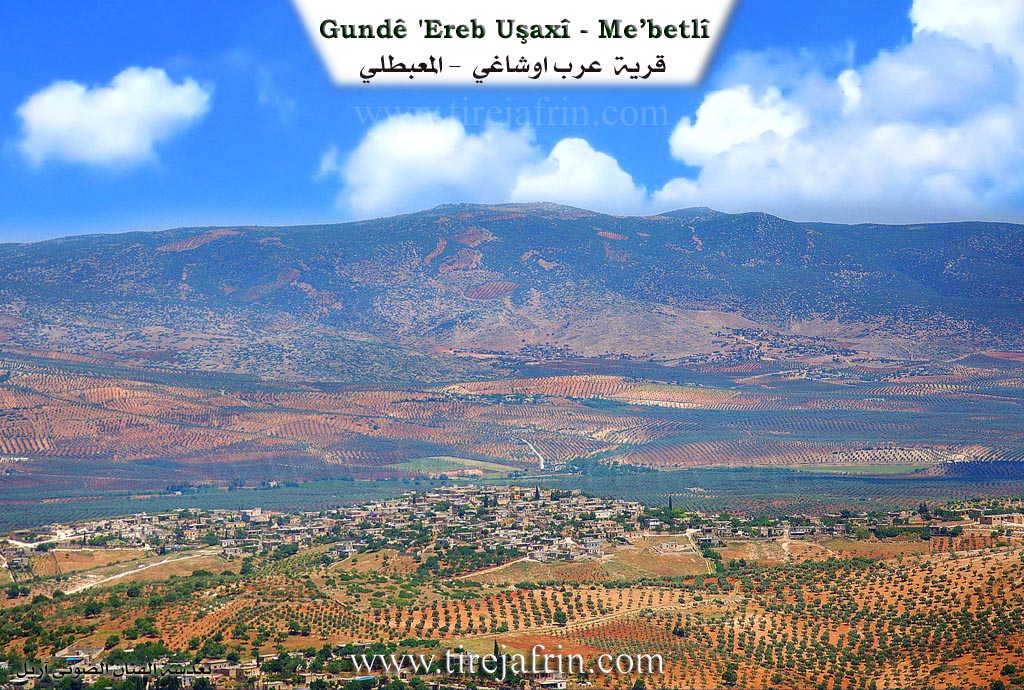
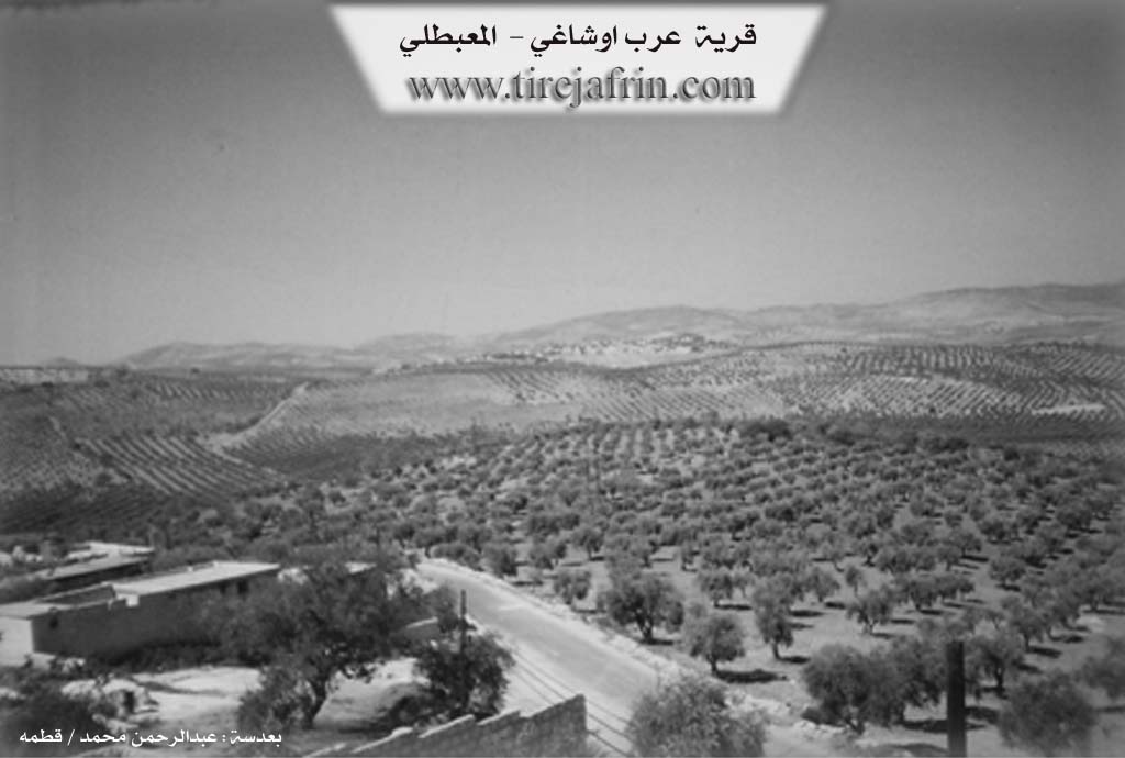
It is a large village located on the summit of a height overlooking wide plains of olive fields.
It is stated in the book عفرين .... نهرها وروابيها الخضراء Efrîn... Her River and Her Green Hills by the writer عبدالرحمن محمد Ebdulrehman Mihemed from the village of Qetme regarding Ereb Uşaxî:
A village in Çiyayê Kurmênc, administratively belonging to the Mabeta sub-district, Efrîn region, Heleb governorate. It is a large village located in the middle section of the mentioned mountain in a high mountainous place, surrounded by slopes on all sides. Its soil is calcareous and flexible. Watercourses descend from it toward the north, and it is covered by oak trees and grazing grass.
It is bordered to the north by a slope and the fertile plain of Ketx planted with olive trees, the Xeta Trêna Heleb-Meydan Ekbez (Heleb-Meydan Ekbez railway), and the villages of Kel Îbo, Ĥemşelek, and Gorkan Jorîn. To the south, it is bordered by a slope, a torrent bed, mountainous heights planted with olive trees, the village of Birîmce, and Mezra Silo. To the east, by a slope, a plain planted with olive trees, the nearby village of Qentera, and the town of Mabeta. To the west, by a slope, a torrent bed, and the villages of Xaziyan Jêrîn and Xaziyan Jorîn.
The number of its houses reaches about 300, and its age is about 400 years. Its old dwellings are made of stone and mud with flat wooden roofs, while modern concrete ones have started to spread in all directions. It has an electricity network, telephone, a primary and preparatory school, and a mosque. There are several modern olive presses and an agricultural cooperative society. It gets its drinking water from the village of Birîmce via a modern water network, in addition to cisterns where rainwater is collected in winter. It is connected to the town of Mabeta to its southeast by a paved road that is 3 km long, which passes through its center to several neighboring villages.
Its residents work in rain-fed agriculture on an area of 410 hectares, of which 10 hectares are irrigated from artesian wells for summer vegetables, pomegranate trees, and walnuts. Rain-fed crops include olives, grains, and legumes, alongside the raising of sheep and goats.
Among the families present in the village: Ĥemşelek family, Kolîn family, Cemkî family, Toşî family, Heso family, Be'bo family, Medîne family, Mela Elî family, Mercan family, Camo family, Xêr family, Xelîl Findiq family, Celĥe family, Xane family.
Village Mukhtar: Mihemed Yûsif.
Among the holders of higher degrees in the village: Ebdullah Ĥebeş (PhD in History / Sudan).
Sources:
- Book: جبل الكرد (عفرين) دراسة جغرافية Çiyayê Kurmênc (Efrîn): A Geographical Study by د. محمد عبدو علي Dr. Mihemed Ebdo Elî.
- Book: عفرين .... نهرها وروابيها الخضراء Efrîn... Her River and Her Green Hills by عبدالرحمن محمد Ebdulrehman Mihemed from the village of Qetme.
- Navenda Tirej Efrîn / Ebdulrehman Hacî Osman.
- 20/12/2013
II. Summary of Ereba from Khalil Sino
Source: https://www.youtube.com/watch?v=efoV3j86EUo
Village History and Origins
The village of Ereba, located in the Afrin region, has a distinct history regarding its name and settlement. According to elder Îbrahîm Xelîl Cimkî, the village was not originally founded by Arab settlers despite its name. The ancestors of the current residents, identified as the lineage of Mala Hesenî Medîne, originally lived at a nearby location called Qitroniyê. They eventually migrated and settled at the current site. The name Ereba was bestowed upon the location because nomadic Arab herders (koçer) frequently visited the area to graze their livestock on its lush pastures. Over time, locals began referring to the spot as "the place of the Arabs," and the name persisted even though the permanent inhabitants were Kurds. The village has a history of hospitality; Îbrahîm Xelîl Cimkî notes that his father, a former mukhtar, would invite travelers on the road to stay, eat, and sleep at their home.
Social Structure and Life
The village social structure is comprised of several distinct families. The most prominent family discussed in the documentary is Cimkî (or Malê Cimkî), to which several speakers belong. Another significant group mentioned is Mala Hesenî Medîne, representing the ancestral core of the village. The elder Arif Cimkî also notes that in the past, the Cefo family was very numerous in the village, though their numbers have since dwindled. Other residents interviewed bear the family names Sîdo and Hesen.
Daily life in the past was deeply communal and agricultural. Arif Cimkî describes how men and women worked together in the fields during the harvest (pehle), using animals to thresh wheat on the threshing floors (bider). Henîfe Sîdo recounts that weddings were grand events held on these threshing floors, lasting anywhere from three to seven days. These celebrations involved traditional drumming (def û zirne) and communal meals featuring dishes like savar (bulgur), germê rizê (rice soup), and îxniyê fasûla (bean stew).
Natural Resources and Landmarks
The village environs are rich in natural resources. Residents like Fîdan still practice the tradition of foraging for wild edible plants, specifically gathering derzink and çukî (types of greens/thistle). In terms of landmarks, the documentary highlights Deşta Dûrimê (the Dûrimê Plain) and a significant water source known as Kaniya Dûrimê. Located in a lower lying area, Kaniya Dûrimê is a popular spot for locals, marked by a large tree where visitors often carve their names or take photographs.
Cultural Expressions
The village maintains a strong connection to Kurdish music and oral history. A young musician, Mihemed Cimkî, plays the tembûr (a stringed instrument), a skill he learned by watching his father. He preserves regional cultural heritage by performing songs by the renowned Afrin artist Elî Cemîl Horo, specifically a song titled "Bejna Rindê," which references "Efrîn" and expresses deep longing and love. The host of the documentary, identified as being from the neighboring village of Baedîna, emphasizes the close ties and shared culture between the villages in the region.
II. Summary of Ereba from Multi Channel
Ereb Ûşaxî is an agricultural village situated twenty kilometers west of Efrîn. It is bordered by the neighboring villages of Xaziyana Jêrîn, Xaziyana Jorîn, Qenterê, and the subdistrict center of Mabeta. The name of the village translates to Sons of the Arabs, reflecting its unique historical origins and demographic makeup.
According to local historian Umer Camo, the village was founded 400 to 450 years ago by nomadic Arabs from Çiyayê His in the southern countryside of Heleb. Three brothers arrived in the area seeking pastures for their sheep. A conflict soon arose with the local Kurds, resulting in the death of one of the brothers. To resolve the blood feud, the Kurds offered a woman in marriage to one of the surviving brothers. Following this reconciliation, the brothers decided to stay rather than return to their homeland. One brother founded Ereb Ûşaxî, while the other settled directly to the north in Hemşelek. The local Neyîm tribe traces its lineage back to these original founders.
Over time, Kurdish families migrated to the village and integrated with the Arab inhabitants. The Hesenelo family arrived from Turkey and built their homes opposite the founders. Later, the Bîlal and Ebû Silêman families also settled in the village to establish mutual protection against regional bandits. Today, the village is fully integrated, with Arab and Kurdish residents intermarrying and sharing all social duties. The villagers also maintain peaceful and cooperative relations with nearby Mabeta, whose population is predominantly Alevi.
The residents of Ereb Ûşaxî preserve several unique cultural traditions. They continue to recognize the Kirîv bond, an ancient form of blood brotherhood established when a man holds another man's son during circumcision. This sacred bond strictly prohibits future intermarriage between the two families. A similar sisterhood bond for women is known as Destik. During local funerals, all villagers halt their work, including shutting down the olive presses, for the entire duration of the burial as a sign of respect. Weddings feature vibrant traditional dances such as Hovî Giran, Çiftetêlî, Hovî Sivik, Hesen Doxle, and Eşî Doxle. A highly esteemed dance called Hovî Xatûnî is performed at the beginning and end of the celebration, traditionally led by a prominent community matriarch.
Economically, the village relies heavily on cultivating its fifty thousand olive trees, specifically the Zeytî and Xilxalî varieties. It also features a historical primary school built around the Islamic year 1354 alongside the local mosque. Traditional craftsmanship survives through elders like Mistefa Mirad, who continues the family trade of blacksmithing and knife making which he has practiced for thirty years. He distinguishes his locally forged blades, which are carefully quenched in oil for hardness, from ordinary Qerbat knives, thus preserving a rare and highly skilled rural craft.
Transcriptions and Subtitles
| Source | Video | Subtitles | Transcript |
|---|---|---|---|
| Khalil Sino 1 | Watch Video | Download SRT | View Transcript |
| Multi Channel 1 | Watch Video | Download SRT | View Transcript |
Foundation/Origin Information of Ereba
A landowner named Ḩemşelek housed his workers of Arab origins in caves at the location. They later built dwellings and settled there.
Source: TirejAfrin Site
Possible Village Name Meaning of Ereba
The village was named "Arab" after the workers and "Ḩemşelek" after their work boss.
Source: TirejAfrin Site
V. Links
- Tirej Afrin:
https://www.tirejafrin.com/site/kura%20afrin%20%20%20mebetli%20-%20ereb%20ushexe.htm - Jawlat:
https://www.youtube.com/watch?v=QwzMv0w1ZlY - Local FB page:
https://www.facebook.com/%D9%82%D8%B1%D9%8A%D8%A9-%D8%B9%D8%B1%D8%A8-%D8%A7%D9%88%D8%B4%D8%A7%D8%BA%D9%8A-103779447984577/ - Link:
https://www.facebook.com/ahmad.afrin - Video:
https://www.youtube.com/watch?v=SY-2iwQEPtA - Link:
https://www.youtube.com/watch?v=UxJZE7hFgCk - Link:
https://www.youtube.com/watch?v=g74dlL6YEV8 - Link:
https://www.youtube.com/watch?v=98Jop2VFI3M - Link:
https://www.youtube.com/watch?v=67UbCsWX2bM - Khalil Sino:
https://www.youtube.com/watch?v=efoV3j86EUo