General Information
Nahiya (Subdistrict)
Mabeta
Also Known As
Al-Jamrakiya, Gemrikê, Gemrukê, Gemrûgê, Gemrûk, Gemrûkê, Kamrok, الجمركية, كمروك, گمروك
Tribes
Maqostina, Şîkakan
Families, Clans, etc.
Dedişka, Ebû Xelîl, Elkêla, Elkîlo, Elmişka, Hafizê Dmol, Hesendêro, Hesensêydî, Heymûnî, Karo, Kera, Mala Cûmî, Mala Dayê, Mala Dwana, Mala Ehmo, Mala Ehû, Mala Elî Sûd, Mala Emdînê, Mala Hesenî Şêxû, Mala Hesfeqîre, Mala Hesko, Mala Mehmedî Xaçkê, Mala Mehûyê Begjî, Mala Mela Yûsiv, Mala Meştî Salehê, Mala Moşûka, Mala Nasif, Mala Qamê, Mala Qurt'ele, Mala Rindik, Mala Xaçkê, Mala Çîçek, Mala Îso, Mala Şukrî Evdê, Mala Şêx Elî, Mala Şêx Hemadê, Malêd Ereba, Miheme Molo, Mêrdox, Qurbe, Xorato, Yehmo, Çamraka, Çemroka, Îbrahîm Xelîl

Photos
Basic Information about Gemrûkê
Source: Ax û Welat
Etymology: Derived from Çem Rûke (River of Rûke) or from the name of the Çemroka or Çamraka family
Springs: Ke'niya Mêwkê
Hills: Girê Încirli
Shrines: Ziyaret, Ziyareta Kehanzerkê, Sazman, Zerke
Ruins: Qonaxa Mêhran
Trees: Dara palîtê
Wells: Bîra Qûçkê, Bîra Încirliyê
Other Landmarks: Aşê Hesen Seydî, Sûlava Gemrûkê, Çemê Efrînê, Geliyê Ke'niyê, Geliyê Qumişlê, Geliyê Besê, Korta Reza, Geliya Zerkê, Bendava Meydankê
Source: Afrin 366
Old Names: Çama
Springs: Şelalat Gemrîkê
Ruins: Aşê Hesensêydî, Keferrûm Xwîntê, Elqê Xwîntê, Tehûnê
Other Landmarks: Zinarê Çama, Serê Firt Xoloq Xwîntê, Seddê Meydankê
Summaries
I. Summary from TirejAfrin Site (English) of Gemrûkê
Source: https://www.tirejafrin.com/site/kura%20afrin%20%20%20mebetli%20-%20gemruke.htm
Stated in the book جبل الكرد (عفرين) دراسة جغرافية Çiyayê Kurmênc (Efrîn): A Geographical Study by د. محمد عبدو علي Dr. Mihemed Ebdo Elî: Gemrk, Kumruk, El-Cumrukiyê /2791 inhabitants - 640 hectares - 12km - 390m altitude/:
There was a main road passing through the current village of Gemrk, connecting the villages of Bilbil and its surroundings with the plain of Deşta Cûmê. The Ottoman customs used to stand on that road near the village, so it was named Gumrik "Customs," then it was Arabized and became El-Cumrukiyê. As for the old village, it was in a location called Qk beside the Çemê Efrînê (Afrin River), and its inhabitants ascended to its current elevated location approximately 150 years ago.
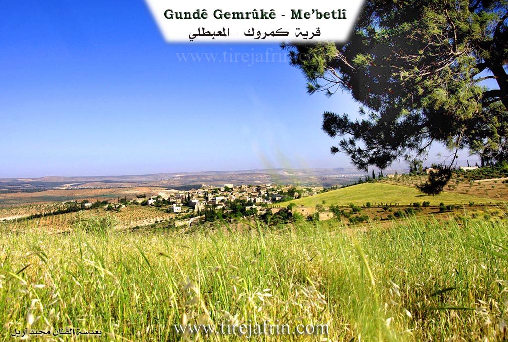
It is a large village located atop a wide plateau, distant from the Çemê Efrînê by a distance of 2km. Beautiful waterfalls exist near its southeastern side on the Çemê Efrînê, and they are called by its name. The village site is a beautiful tourist spot frequented by summer vacationers.
Stated in the book: عفرين .... نهرها وروابيها الخضراء Efrîn... Her River and Her Green Hills by the writer عبدالرحمن محمد Ebdulrehman Mihemed from the village of Qetme: Gemrk: A village in Çiyayê Kurmênc, following the district of Mabeta, Efrîn region, Heleb governorate. It is a large village located in the central part of the mentioned mountain, on a mountainous elevation and limestone plateau furrowed by several watercourses sloping towards the valley of the Çemê Efrînê. It is 15km away from the town of Mabeta towards the northeast.
Its soil is clay. It is bordered on the north by a slope and several watercourses planted with olive trees, the village of Şorbe and Sîmalik; on the south by a slope planted with olive trees, Geliyê Sîlê, and the nearby village of Ereb Şêxo at a distance of 1km; on the west by a slope, Geliyê Sîlê, mountainous highlands planted with olive trees, and the village of Şêx Hûtko; and on the east by a slope, Geliyê Sîlê, the course of the valley of the Çemê Efrînê, the village of Meydankê, the Benda 17 Nîsanê (17 April Dam), and the village of Helûbiyê Mezin.
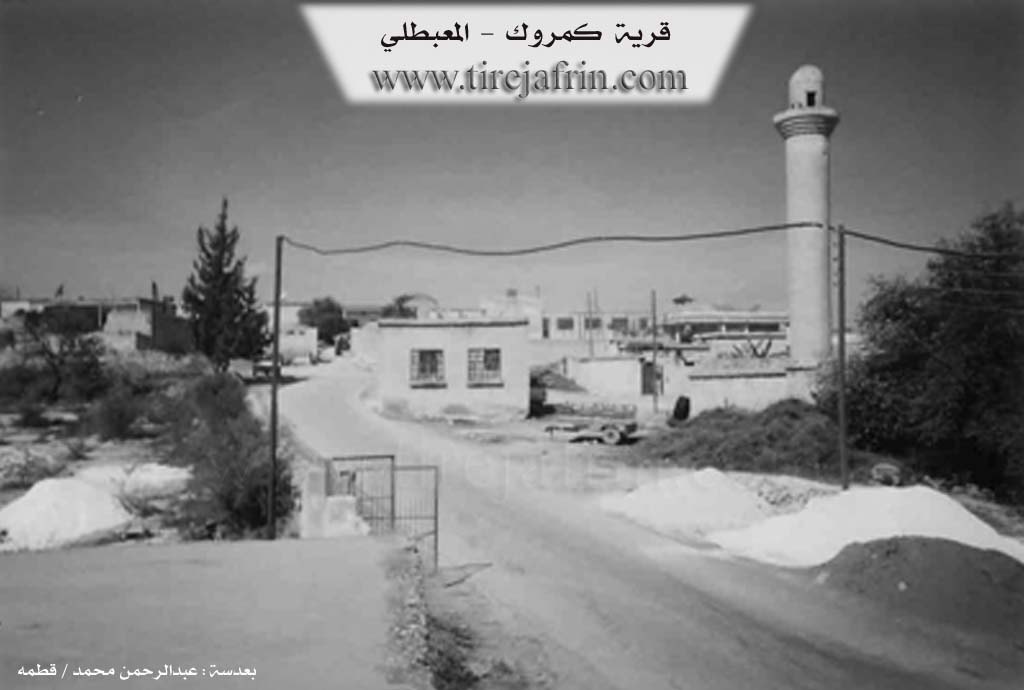
The number of its houses reaches about 200 houses. Its age is about 500 years, and it is among the old villages in the region. Its old houses are stone and mud with flat wooden roofs, while the modern ones are cement, spread to the west, north, and south. Available in it are an electricity network, a primary and preparatory school, and an old mosque in the center of the village. It contains a modern press for pressing olives. A paved road connects it to the district center, passing through its center to several neighboring villages.
The village drinks from a water network from a well present in the village and from cisterns in which winter rain water is collected. The residents work in rain fed agriculture on an area of 300 hectares with grains, olives, vines, and legumes. They cultivate via irrigation from artesian wells or by pumping from the Çemê Efrînê summer vegetables, cotton, and sugar beet, alongside raising sheep and goats.
Among its most important families are the family of Îbrahîm Xelîl, the first to inhabit the village, and the family of Elkîlo and Karo. It is mentioned that Doctor Yûsif Hesen, holder of a doctorate degree in media psychology from France and currently teaching at the University of Qatar, is one of the sons of this village.
Mukhtar of the village: Mihemed Menan Menan
Sources:
- Book: جبل الكرد (عفرين) دراسة جغرافية Çiyayê Kurmênc (Efrîn): A Geographical Study by د. محمد عبدو علي Dr. Mihemed Ebdo Elî.
- Book: عفرين .... نهرها وروابيها الخضراء Efrîn... Her River and Her Green Hills by عبدالرحمن محمد Ebdulrehman Mihemed from the village of Qetme.
Preparation and execution:
- Manager of the Tirej Efrîn site: Ebdulrehman Hacî Osman
- 20/12/2013
II. Summary of Gemrûkê from Ax û Welat
Source: https://www.youtube.com/watch?v=jF1HDrGmbmo
The village of Gemrûkê, located in the Mabeta district of the Efrîn region (also known as Çiyayê Kurmênc), is a historically significant settlement renowned for its water sources and ancient infrastructure. The name of the village is debated among residents; some attribute it to Çem Rûke (meaning "River of Rûke" or "Shaking River"), while others believe it stems from the Çemroka or Çamraka family, who were among the first settlers. This family belonged to the Şîkakan tribe. The village has a rich multicultural past, having been home to Kurds, Arabs, Armenians, Êzîdî, and Jews. While the Armenians and Jews (specifically the Mêrdox and Heymûnî families) have since left, their historical presence is marked by sites like the ruins of a priest's mansion, Qonaxa Mêhran. The Hesfeqîre family is noted as being originally Êzîdî but converted to Islam over time.
The history of Gemrûkê is deeply intertwined with the Aşê Hesen Seydî, a watermill located on the Çemê Efrînê. Residents estimate the mill and the associated dam structure (Sûlava Gemrûkê) to be approximately 700 to 750 years old, constructed with lime rather than cement. The mill was a vital economic hub for the entire region, drawing people from as far as Enqere and Aleppo, as well as local villages like Şiyê, Reco, and Meydanleqê. It was owned and managed by various local figures throughout history, including the Mala Mela Yûsiv, Mala Şêx Elî, and an Armenian named Bêkarê Xelîl. The mill operated until the late 20th century (cited as either 1979 or 1997) when the flow of water was disrupted by the construction of the Bendava Meydankê and actions by the Syrian regime.
The village is also a center for traditional healing practices centered around the Geliya Zerkê and the Ziyaret shrine. Locals believe this site cures jaundice (known locally as "nexweşiya Zerkê"). The ritual typically takes place on Wednesday mornings before sunrise. Families bring afflicted children to wash them with water from the site, feed them a small amount of soil called tiberk, and leave pieces of the patient's clothing on the Dara palîtê (oak tree) as a symbol of leaving the illness behind. Offerings of eggs, bread, and bulgur are also common.
Culturally, Gemrûkê has produced notable figures such as Xoce Emdînê, a religious scholar who translated Islamic texts and the Mawlid into Kurmanji, and the singer Henan, who recounts receiving his musical gift in a dream. The village social structure was historically maintained by elders (rûspî) such as Menanê Têwed, Mehmedê Eîşan, and Evdê Qurt'ele who settled disputes. Today, despite displacement caused by the conflict in Syria, the village remains a popular destination for tourism due to the restored waterfalls and natural beauty, with approximately 500 households residing there.
II. Summary of Gemrûkê from Afrin 366
Source: https://www.youtube.com/watch?v=JSFg1yq8HlM
The village of Gemrîk, located in the Afrin region, is a historically significant settlement with a deep connection to its surrounding geography and water sources. Local residents estimate the history of the village to be between two thousand and three thousand years old. The inhabitants identify closely with the name Çama, stating that their origins trace back to this lineage or location, and a prominent rock formation overlooking the area is named Zinarê Çama. The village currently contains approximately sixty households.
The social structure of Gemrîk is defined by the Maqostina tribe. Several prominent families and lineages are mentioned by the residents, including Mala Dayê (also referred to as Malê Dayînê), Mala Dwana, and the lineage of Hesendêro. The host visits the home of Ebû Xelîl, and other individuals such as Xorato, Miheme Molo, and Hafizê Dmol are identified as residents or contributors to the documentation of the village.
Gemrîk is renowned for the Şelalat Gemrîkê, a waterfall and spring system that was once a vibrant recreational hub with restaurants and mills. However, the documentary highlights a severe water crisis; the waterfall has largely dried up, a situation the locals attribute partly to the Seddê Meydankê holding back water and partly to general drought. The dry riverbed has revealed ancient features, such as the ruins of Tehûnê (old mills) and specifically Aşê Hesensêydî, a historic mill owned by the Hesensêydî or Hesendêro family. This mill is now described as ruined and flattened.
The landscape around Gemrîk is dotted with specific micro toponyms and historic sites preserved in the collective memory of the elders. These include Keferrûm Xwîntê, Elqê Xwîntê, and Serê Firt Xoloq Xwîntê. The terrain also features underground caves, referred to simply as "kûk," which are described as being beneath the soil. Due to the scarcity of surface water, residents are forced to drill deep wells, with the cost of drilling reaching high prices per meter. Despite the heat and the drying of their famous waterfall, the community maintains a strong connection to their land and its ancient history.
II. Summary of Gemrûkê from Khalil Sino
Source: https://www.youtube.com/watch?v=ERH5E_83VqM
The documentary provides a vibrant glimpse into the festive atmosphere in the village of Gemrûkê during a communal holiday celebration. The presenter visits the area during a period that coincides with Cejna Erefatê and Cejna Newrozê, capturing the joyous mood of the local population and visitors. Despite being the third day of the holiday, the location remains heavily crowded with sightseers and picnickers. People from Heleb and across Efrîn have flocked to the area to celebrate, highlighting the village as a popular destination for community gatherings and nature outings.
Throughout the broadcast, the host emphasizes the importance of preserving the natural beauty of Gemrûkê. He repeatedly urges visitors to maintain cleanliness at their picnic sites. He advises the crowds to gather their trash into bags, avoid leaving waste in the water, and ensure that any fires are safely controlled and extinguished. This focus reflects a deep communal appreciation for the local landscape and shared natural resources.
During the festivities, the presenter interacts with several attendees who share their experiences. He speaks with a local man from Gemrûkê who expresses happiness at seeing Efrîn thriving and full of life once again. The local man notes that the people are enjoying themselves as they mingle and celebrate together. Later, the host meets a young man whose family originally hails from the nearby village of Çermîlê. The encounter reveals the strong connections between the diaspora and their homeland. The young man explains that he recently arrived from Lubnan, while his sister traveled all the way from Holenda to be part of the celebrations. He notes that he had not visited the region for twenty years. Seeing the area revitalized and the people rejoicing after enduring significant hardships brings him immense joy. He expresses his hope that the community will continue to find happiness and relief. The host also briefly greets an older man named Henîf while sharing tea and conversation.
The documentary is heavily interspersed with traditional folk music that praises the beauty and heritage of the region. The songs celebrate the olive trees that are characteristic of the mountains of Çiyayê Kurmênc. The lyrics reflect a deep longing for the homeland, describing the region as a paradise with lush valleys, majestic peaks, and bountiful olive groves. The musical segments echo the sentiments of the visiting diaspora, capturing a profound yearning for the ancestral land and its rich cultural identity. Overall, the footage serves as a lively record of a community reuniting to celebrate their culture, enjoy their natural surroundings, and reconnect with their roots in the heart of Gemrûkê.
II. Ax û Walat Book 2
35
GEMRÛK
24.7.2017
[Image of the village of Gemrûk]
Gemrûk and Meydankê are the most beautiful villages on the Efrîn river. Therefore, they have become places of enjoyment and excursions for the people of the region.
The village of Gemrukê is affiliated with the Mabeta district of the Efrîn canton, located 14 km east of the town of Mabeta and 22 km north of the city of Efrîn.
The name of the village comes from the phrase ((ÇEM RÛK)) or (by the river), because the village is near the Efrîn river.
Another view says that it comes from the name of a family from the village named (Çemraka), and this family is still in the village.
36
The Çemraka family was the first family to settle in this area, and the village was named after them; they are from the Şikaka tribe. Later, the Elkêla family came.
The village of Gemrûk is composed of a multicultural mosaic, of Kurds, Arabs, Armenians, Yazidis, and Jews who had previously populated the village, but now there are no Armenians left. They used to have a school in the village, and their priest's residence, named ((Mihran)), was in the village.
Two Jewish individuals named ((Mirdoq and Heyûmî)) lived in the village for many years and were engaged in trade. 70 years ago, they moved to the city of Aleppo.
There is a Yazidi family in the village named ((Hesfeqîr)), but they have now become Muslims.
There are 24 families in the village:
The families of Çermoka, Elkêla, Kera, Elmişka who came from the village of Miskê, Deûşka, Qurt Elî, Hesenê Şêxo, Şêx Elî who are originally from Kobanê, Êhmo, Nasîf who came from the village of Me’mila, Hesko who came from the village of Xelîlaka, Umdînê, Bêgacî, Cûmî, Rindik, and two Arab families (Hec Mehmûd and Mihemed Elî) from the Imêrat tribe, Mihemedê Xeckê from the village of Elemdara, the Umero family from Mûş who came from the village of Kulisîk after the Şêx Seîd rebellion, the family of Şukrî Evdê who came from the village of Çeqmaqê Mezin, Mecîdê Sêlih from North Kurdistan, Îso, Hesenê Resûl, Şêx Hemadê, Laço, and the Gurdo family who came from the village of Recê.
37
There are around 300 houses in the village and more than 3000 people live there, but many people have moved abroad after the Syrian crisis.
To the east of the village are the town of Meydankê, the Meydankê dam, the Kaniyê valley, and the Zerkê shrine.
To the south are the village of Ereb Şêxo and the Efrîn river, where the Gemrûkê Waterfalls flow, which has become the most interesting place for trips and excursions in the spring and summer, with people from near and far visiting it.
[Image of people at the Gemrûkê Waterfalls]
To the west of the village are the village of Şêxûtka and Korta Reza, and to the north, the villages of Sêmalka and Şorbe, and the Incirlik hill where there is an ancient water well.
There are two shrines to the west and north of the village, Sazman and Zerkê.
The people of the village make their living from agriculture, from olive groves, due to the abundance of water sources from the river and wells,
38
vineyards, and vegetable gardens, and they also plant lentils, chickpeas, barley, and wheat.
Some families also raise livestock such as sheep, goats, and cattle. There are 2 sewing workshops, 2 olive presses, 10 shops in the village, and a restaurant by the waterfalls, where many young men from the village work.
Nearly 50 people work in the institutions and bodies of the Democratic Autonomous Administration.
The Mill of Hesenê Seydê is located to the south of the village; it was once a famous water-powered mill, and people from many villages would come to grind their flour. It was in operation until 1997 and stopped after the construction of the Meydankê dam.
The Gemrûkê Waterfalls were destroyed by the Regime, but after the Rojava Revolution, they were restored.
There are 6 martyrs from the village:
Martyr Welat, Hemîd, Rênas, Hemze, Doxan, and Martyr Şêristan.
The village's commune is named after Martyr Hemze, the primary school is named after Martyr Hemîd, and the middle school is named after Martyr Rênas.
There is a Culture and Arts Academy Center and a mosque in the village.
Xocê Umdînê was an Islamic cleric, and he would have the mawlid recited in the Kurdish language. He wrote several books on the Islamic religion and passed away in 1963.
39
Mihemed Menan and Şêx Hesen were known as elders of the village; they provided many services to the people of the village.
It is worth mentioning that the village's water well provides drinking water to 5 villages: Sêmalka, Şêxûtka, Emara, Ereb Şêx, and the village of Gemrûkê.
Transcriptions and Subtitles
| Source | Video | Subtitles | Transcript |
|---|---|---|---|
| Afrin 366 1 | Watch Video | Download SRT | View Transcript |
| Ax û Welat 1 | Watch Video | Download SRT | View Transcript |
| Khalil Sino 1 | Watch Video | Download SRT | View Transcript |
Foundation/Origin Information of Gemrûkê
The old village was in a location called Qûçkê beside the Afrin River. Its inhabitants moved to the current location about 150 years ago. The first to inhabit the village was the Ibrahim Khalil family.
Source: TirejAfrin Site
Possible Village Name Meaning of Gemrûkê
Ottoman customs used to stop on a main road near the village, so it was named Gemrûk (customs).
Source: TirejAfrin Site
V. Links
- Tirej Afrin:
https://www.tirejafrin.com/site/kura%20afrin%20%20%20mebetli%20-%20gemruke.htm - Ax û Welat:
https://www.youtube.com/watch?v=YlpzDw1XBFo - Videos:
https://www.youtube.com/watch?v=IZjvyswmOTY - Link:
https://www.youtube.com/watch?v=MBHkfsTl7Xk - Link:
https://www.youtube.com/watch?v=2Mgc9A3C164 - Link:
https://www.youtube.com/watch?v=jF1HDrGmbmo - Afrin 366:
https://www.youtube.com/watch?v=JSFg1yq8HlM - Khalil Sino:
https://www.youtube.com/watch?v=ERH5E_83VqM