General Information
Nahiya (Subdistrict)
Cindires
Also Known As
Badr, Hikja, Hêkiçê, بدر, هيكجه, هيكچة
Tribes
Delo
Families, Clans, etc.
Delû, Kûrû, Mala Alikî, Mala Elmî, Mala Hesenî, Mala Mistê Miho, Mala Nebo, Mihê, Selîm, Tênê

Photos
Basic Information about Hêkiçê
Source: Ax û Welat
Etymology: Derived from the phrase "Hê kiçê" meaning "Hey girl" from a legend about a shepherd calling to a vanishing girl; or from "Hêk" and "çiyê" meaning "Egg of the mountain" due to the village's shape
Shrines: Kozê Qey|Kozê Qey / Kozê Kurrê
Trees: Dara gûzberiyê
Other Landmarks: Geliyê Cercemê
Summaries
I. Summary from TirejAfrin Site (English) of Hêkiçê
Source: https://www.tirejafrin.com/site/kura%20afrin%20Cindires%20-%20hekice.htm
It came in the book جبل الكرد (عفرين) دراسة جغرافية Çiyayê Kurmênc (Efrîn): A Geographical Study by د. محمد عبدو علي Dr. Mihemed Ebdo Elî: Hki, Hêkçe, Bedr /1090n - 14km - 320m/:
A Kurdish name in form and pronunciation. Hgi: in Kurdish means "the noble and brave." And perhaps the correct one is that it is Hêkce, which is a Kurdish naming given to the sheep in its second year.
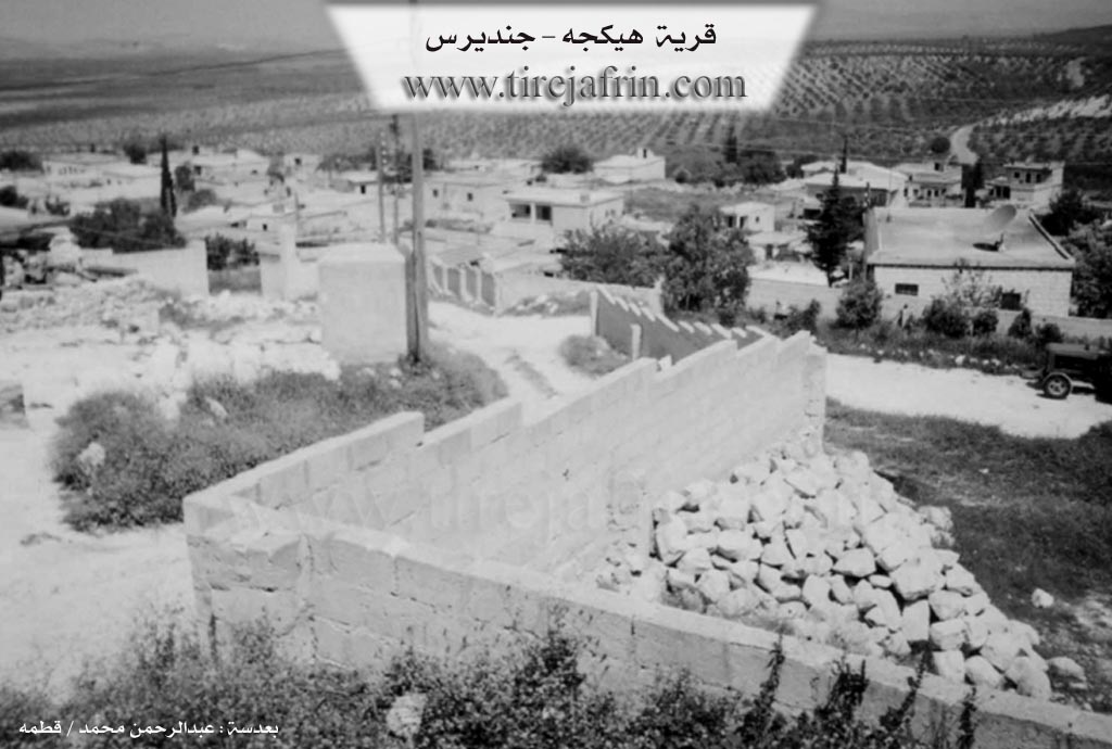
It is a small village located on one of the highlands of the western slope of Çiyayê Kurmênc, and it overlooks the Amyq plain to the west.
And it came in the book: عفرين .... نهرها وروابيها الخضراء Efrîn... Her River and Her Green Hills by the writer عبدالرحمن محمد Ebdulrehman Mihemed from the village of Qetme:
Hêkce: A village in Çiyayê Kurmênc, follows the Cindirês township, Efrîn region, Heleb governorate. It is a large village located on the western slope of the mentioned mountain in its southern part, above a plateau overlooking the Amyq plain with alluvial soil to the west. It is 2km north of Merwanê Jorîn.
It is bordered to the north by a slope and mountain highlands planted with olive trees and the village of Enqelê and Sînara; and to the south by a mountain slope planted with olive trees and the village of Merwanê Jêrîn; and to the west by a slope, the Amyq plain, the Riya Şiyê (Şiyê road), and the Turkish borders directly; and to the east by a mountain highland and a deep watercourse called Geliyê Cercem and the village of Baziyanlî and Zivingê.
The number of its houses reaches about 135 houses and its age is about 300 years. Its old houses are stone and mud with wooden ceilings, and the modern ones are cement, which have begun extending north and south. Available in it are an electricity network, a primary and preparatory school shared with Merwanê Jêrîn, a small mosque, and a telephone line.
It connects with the township center and neighboring villages by a newly paved road. The village drinks from a network connected to the water network of the Şiyê township center and its villages. The road to the town of Cindirês is paved, its length is 14km.
Residents of the village work in rain-fed agriculture (85% of cultivated lands) and vegetables and fruit trees from the waters of artesian wells. Its most important crops are (olives, vines, figs, grains, legumes) alongside raising sheep and goats.
Village Mukhtar: Zekî Ebdo Mihemed
Preparation and execution:
Manager of Navenda Tirej Efrîn: Ebdulrehman Hacî Osman
20/12/2013
Sources:
- Book: جبل الكرد (عفرين) دراسة جغرافية Çiyayê Kurmênc (Efrîn): A Geographical Study by د. محمد عبدو علي Dr. Mihemed Ebdo Elî.
- Book: عفرين .... نهرها وروابيها الخضراء Efrîn... Her River and Her Green Hills by عبدالرحمن محمد Ebdulrehman Mihemed from the village of Qetme.
- Studies of Navenda Tirej Efrîn / Ebdulrehman Hacî Osman.
II. Summary of Hêkiçê from Ax û Welat
Source: https://www.youtube.com/watch?v=CrKsUIHC_FI
The village of Hêkîçê is located in the Şiyê district of the Efrîn region in northwestern Syria. It sits between the districts of Şiyê, Quruxan, Rihanê, and Jindires. The name of the village is the subject of two distinct local origin stories. According to a legend recounted by residents, a shepherd named Şêx Poro once saw a girl wearing a bridal dress near a tree known as Dara gûzberiyê. When he called out "Hê kiçê" meaning "Hey girl" she vanished, and the phrase evolved into the village name. Alternatively, the name may describe the village's topography, combining "hêk" meaning egg and "çiyê" meaning mountain, as the settlement resembles a large egg nested in the terrain.
Historically, the residents of Hêkîçê did not own the land they cultivated. Before the governance of the Baath party, the village was the property of Omer Aẍa and Ehmed Axa who resided in the nearby village of Hemamê. The villagers of Hêkîçê worked as sharecroppers (cotkar) for these feudal lords. The elder Arif describes a progression of habitation where the ancestors originally lived in caves (şikeft) located within the village. They later moved into huts (zinc) and eventually built stone houses (xanî). The village was founded by four original families: Delû, Kûrû, Mihê, and Tênê. Later arrivals included the Selîm family, along with a few Arab families and a Kirmanc family who settled there.
Agriculture has shifted significantly over the last half century. In the era of the aghas, villagers grew wheat, barley, lentils, chickpeas, corn, cotton, and sesame. They also operated molasses presses (mehser) to process grapes. Approximately fifty years ago, olive trees were introduced and have since become the primary crop. Water scarcity was historically a major challenge. Residents used donkeys to haul water from the Geliyê Cercemê valley to the east, a task described as very difficult. In modern times, the digging of wells has solved this issue, though the valley itself has dried up.
The social and religious life of Hêkîçê is marked by deep rooted traditions. During Cejna Qurbanê, families prepare traditional Efrîn dishes such as Sermîsok (meat pies), Şûrbadşîr (yogurt soup), and Kutawî. These are distributed to neighbors as charity for the souls of the deceased. A notable resident, Eziddîn, practices traditional cupping therapy (hîcem), a skill he claims has been passed down in his family for two hundred to three hundred years. He treats ailments like migraines (şeqîq) and numbness (distik) using techniques he attributes to the Sunnah of the Prophet. Another prominent figure is Şêx Henan of the Rifaî Qadirî order, who leads religious chanting and ceremonies. To the east of the village lies a sacred site known as Kozê Kurrê or Kozê Qey, linked to the legend of the vanishing girl.
II. Summary of Hêkiçê from Multi Channel
The documentary provides an in depth look at Hêkiçê, a village located between the Cindirêsê and Şiyê districts in the region of Afrîn. According to the village mukhtar, Husên Evdo Mihemed, the settlement was founded approximately 550 years ago. Its unique name derives from the phrase Hêy kiçe meaning Hey girl, which refers to a historical figure named Zenûba. She lived in a massive local cave known today as Şikefta Zenûba.
The earliest inhabitants initially took shelter in the large caves of the area before building homes. The first families to settle included the Mala Alikî, Mala Elmî, Mala Hesenî, Mala Mistê Miho, and Mala Nebo. The original village population is largely associated with the Delo tribe. Oral traditions passed down by village elders suggest some of these ancestors migrated to the region from Meletiye in Tirkiyê. Over the centuries, the village witnessed the influence of various empires and mandates, with locals recounting eras under the Roman empire, the Osmanî empire, and the Fransî mandate. For three hundred years, the villagers have lived peacefully alongside their Arab neighbors. The elders also express pride in the broader history of Sûrî, mentioning notable local leaders like Ihmed Axa Gênc alongside historical political and military figures such as Çîçeklî, Nizameddîn Hisên, Zeîm, Atasî, and the martyr Yusif el Ezme who fell at Meyselûn.
In terms of geography and landmarks, apart from Şikefta Zenûba, the surrounding area features Geliyê Cercem. This eastern valley once housed seven ancient watermills, known locally as Aşên kevin, which were used to grind wheat utilizing the flowing water. There are also older unnamed ruined tombs scattered along the ancient valley paths.
Daily life in Hêkiçê heavily revolves around the olive harvest, though recent droughts have severely impacted the yield. Villagers such as Zeîm Mistefa, Meqbûle, and Celal from the neighboring village of Çeqmaqa describe the harsh realities of agricultural work today. Women in the village, including Sedîqa Sebrî Mihemed and Ewa the daughter of Şêx Kûrû, recount the severe physical labor they endured in the past, such as fetching water and collecting heavy loads of wood. Despite these historical hardships, they share fond memories of their youth, playing traditional Kurdish games like hûkê, tûşe, and çavşironek.
In modern times, the village faces new challenges. The devastating 2023 earthquake deeply traumatized the residents. Many, including elderly women, continue to sleep outside in tents out of fear, abandoning their homes completely despite the difficult conditions. Despite the lingering trauma, economic struggles, and regional instability, the villagers of Hêkiçê maintain profound resilience, a deep attachment to their ancestral land, and a constant longing for a free and peaceful Kurdistan.
Transcriptions and Subtitles
| Source | Video | Subtitles | Transcript |
|---|---|---|---|
| Ax û Welat 1 | Watch Video | Download SRT | View Transcript |
| Multi Channel 1 | Watch Video | Download SRT | View Transcript |
Possible Village Name Meaning of Hêkiçê
Hêgiç in Kurdish means "arrow and courage". It may also be from Monouj, a Kurdish name for rams in their second year.
Source: TirejAfrin Site