General Information
Nahiya (Subdistrict)
Mabeta
Also Known As
Al-Yakhor, Iki Axor, Kaxirê, Kaxrê, الياخور, ايكي آخور, كاخرة, ياخور, كتخ, كوخره
Families, Clans, etc.
Bavê Ehmed, Brokî, Hec Qasim Axa, Hisên, Krad, Mala Hecî Îmo, Mala Kera, Mala Qesim, Mala Reşo, Mala Simê, Muxtêr, Qedrî Ebû Ciwan

Photos
Basic Information about Kaxrê
Source: Ax û Welat
Etymology: Derived from the Turkish phrase 'Îkî Axir' meaning Two Barns or Two Stables, which evolved into Kaxrê
Foundation Date/Period: 400 years ago
Springs: Kaniya Gewrkê, Kaniya Rûta
Hills: Xerab Reşkê, Çiyayê Kaniyê Gawirkê, Çiyayê Na'sû, Sirtka Elîfê, Çiyayê Hecî Êmû
Wells: Bîra Gund, Serunca Kera
Summaries
I. Summary from TirejAfrin Site (English) of Kaxrê
Source: https://www.tirejafrin.com/site/kura%20afrin%20%20%20mebetli%20-%20kaxre.htm
The following is stated in the book جبل الكرد (عفرين) دراسة جغرافية Çiyayê Kurmênc (Efrîn): A Geographical Study by د. محمد عبدو علي Dr. Mihemed Ebdo Elî:
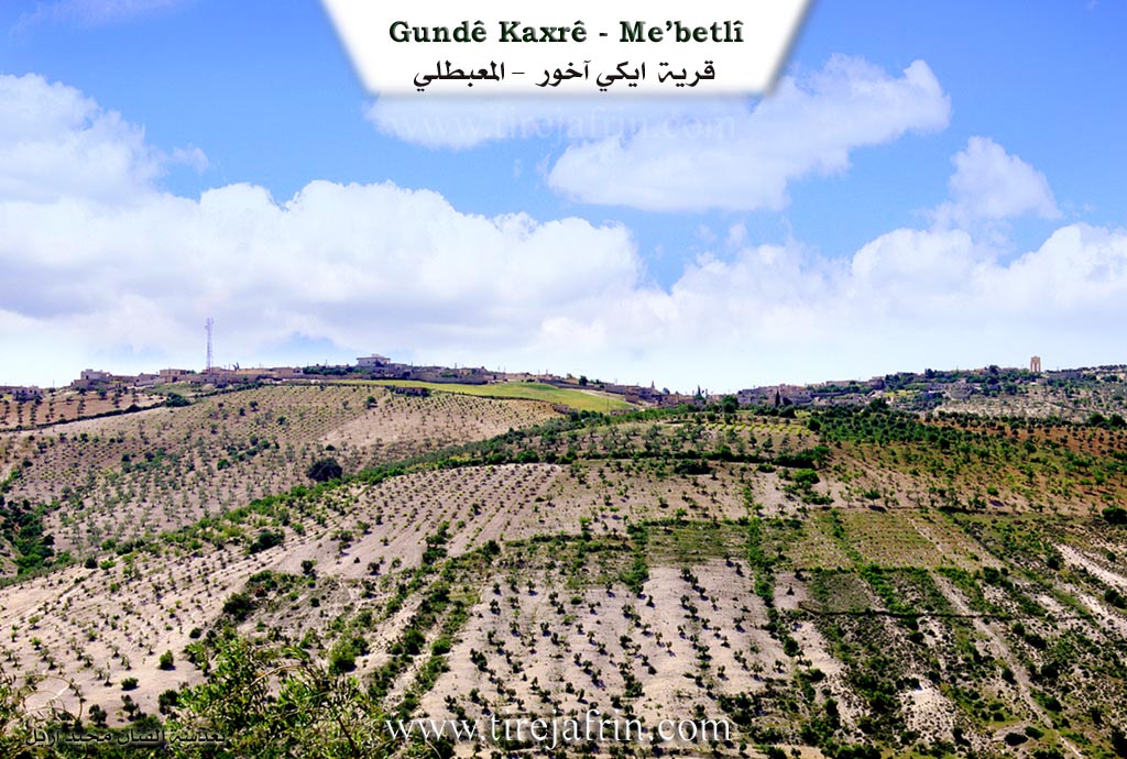
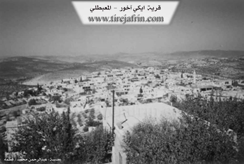
Kaxr, Îkî Axur, Yaxûr /4105 inhabitants - 600m - 5km - 660m/:
"İki" is Turkish for two, and "Axur" is Kurdish for stable or barn (axur + iki). Thus, the name is compound and means "Two Stables." We believe the popular name is a corruption of this previous compound name. Additionally, "Axur" was an important military rank during the Mamluk era; the holder of this title was responsible for the Sultan's stable and all the horses and camels within it /Book of Ibn Aja, p. 251/.
It is a large village situated on the summit of a limestone plateau. Its location is beautiful and fortified. It contains a station for forest protection.
The following is stated in the book عفرين .... نهرها وروابيها الخضراء Efrîn... Her River and Her Green Hills by the writer عبدالرحمن محمد Ebdulrehman Mihemed from the village of Qetme:
Îkî Axur / Yaxûr: A village in Çiyayê Kurmênc, administratively belonging to the Mabeta district, Efrîn region, Heleb governorate. It is a large village located in the central part of the mentioned mountain range, on the northern slope of a limestone plateau whose lands slope northward. It is furrowed by watercourses from the east and west. It is located 11km southwest of Mabeta.
It is bordered to the north by slopes, several watercourses, Wadî Cercem, and the villages of Şêrkanlî and Mîrkanlî. To the south, it is bordered by a high mountain chain planted with olive and forest trees, and the villages of Satiyanlî and Xaltan Xerbî. To the west, it is bordered by rugged mountainous heights, Wadî Sîlê planted with forest olive trees, and the village of Rotanlî. To the east, it is bordered by a slope and Wadî Sîlê planted with olive, walnut, and apricot trees, high mountainous heights, and the villages of Tibe Xazî, Biyûk Obê, and Darkîr Kebîr.
The number of houses reaches approximately 300, and its age is about 400 years. Its houses are made of stone and mud with flat wooden roofs, though modern cement dwellings have begun to spread around them to the south, north, and west. The village has an electricity network, a primary and preparatory school, a telephone center, an old mosque in the village center, a forest protection station, and an agricultural cooperative society. There are also several olive presses. A municipality was established there in 2003.
Its residents drink water from artesian wells and cisterns that collect rainwater in winter. The inhabitants cultivate 570 hectares of rainfed land with grains and olive trees. They also cultivate 30 hectares of irrigated land from artesian wells with summer vegetables, walnuts, almonds, apricots, and cherries. This is in addition to raising sheep and goats. A section of the residents works in the charcoal industry, while others work in various professions, services, and commercial activities. It is connected to the district center by an asphalt road, and it is considered one of the old villages in the Mabeta district.
It is mentioned that Dr. Mistefa Reşîd, who holds a PhD in the Kurdish language, is from here. Also Mihemed Zêno (PhD in Philosophy / Russia) is one of the sons of this village, as well as the Krad family known in the field of television photography, the late Professor Îbrahîm Xelîl Îsa (former Mufti of Efrîn), and the journalist Nîdal Henan.
Village Mukhtar: Ehmed Qasim Ebdulrehman
Preparation and Execution:
Manager of Tirej Efrîn site: Ebdulrehman Hacî Osman
20/12/2013
Sources:
- Book: جبل الكرد (عفرين) دراسة جغرافية Çiyayê Kurmênc (Efrîn): A Geographical Study by د. محمد عبدو علي Dr. Mihemed Ebdo Elî.
- Book: عفرين .... نهرها وروابيها الخضراء Efrîn... Her River and Her Green Hills by عبدالرحمن محمد Ebdulrehman Mihemed from the village of Qetme.
II. Summary of Kaxrê from Ax û Welat
Source: https://www.youtube.com/watch?v=Z3TD4PqcNHU
The village of Kaxrê, located in the Mabata district of Efrîn, holds a history that dates back approximately four centuries. According to local elder Menan Hiso, the village name possesses a distinct etymological origin rooted in the Turkish language. The settlement was originally known as Îkî Axir, which translates to "Two Barns" or "Two Stables." This name arose because the site initially consisted of only two households or structures that served as a resting point for caravans. Merchants and travelers moving livestock between the Turkish region of Qeraxan and the city of Heleb utilized this location as a strategic waystation. Over time, the name evolved linguistically; the "Îkî" was dropped and "Axir" morphed into the current Kurmanji pronunciation Kaxrê.
The social formation of Kaxrê was a defensive consolidation. Roughly 400 years ago, various families lived scattered across the surrounding hills and water sources rather than in a centralized village. However, the lack of a central government and the prevalence of bandits and raiding parties forced these isolated households to gather together for mutual protection. This unification created the modern village structure. Menan Hiso and other residents detail exactly where these founding families originated before they coalesced. The Mala Qesim family moved from a location known as Kaniya Gewrkê. The Mala Kera family came from Serunca Kera. The Mala Simê family arrived from the western area called Krêcê. The Mala Hecî Îmo family came from Ciyê Hecî Îmo. Another notable lineage mentioned is Mala Reşo. These families abandoned their isolated dwellings near specific springs and ridges to form the nine original households of the unified village.
Geographically, Kaxrê is situated among a series of notable natural landmarks and hills that define its boundaries. The villagers identify the surrounding high grounds by names such as Çiyayê Na'sû, Sirtka Elîfê, and Çiyayê Hecî Êmû. To the west lies Kaniya Rûta, and the area also contains the ridge of Xerab Reşkê. Water sources have always been vital to the community, with Bîra Gund being a particularly significant site. Locals believe this well is ancient, potentially dating back to the Roman era, and it continues to provide water to this day.
The village has built a robust reputation across the Efrîn region for its agriculture, specifically its walnut production. Unlike the irrigated plains of the Cûmê or Hemqe, Kaxrê relies on dry farming, known locally as bejî. This method is said to give their produce, particularly walnuts and olives, a sharper and more distinct flavor compared to irrigated crops. The village boasts between 10,000 and 15,000 walnut trees, and the processing of this crop is a central part of domestic life. Women in the village, such as Leyla, prepare elaborate preserves like leçer and magdûz using green walnuts, alongside dried fruit pulps called bastiq made from apricots and figs.
Cultural heritage remains a vibrant part of daily life in Kaxrê. Elders maintain the tradition of oral history and song, with residents reciting epics about legendary figures like Evdê Milhem. The younger generation continues these traditions through groups like Koma Şehîd Xoşnav, ensuring the artistic legacy of the village endures alongside its agricultural fame.
II. Summary of Kaxrê from Afrin 366
Source: https://www.youtube.com/watch?v=NAlX-xkPVkY
The village of Koxre is situated in the Efrîn region, administratively falling under the Mabat (Mabeta) district. It lies approximately seven kilometers from Bobatê and serves as a significant settlement with an estimated population of several hundred households, though many residents are currently in the diaspora.
The history and current state of Koxre are heavily defined by its traditional architecture and recent seismic events. The village is characterized by its large, interconnected courtyards (hewş), where houses are often built back to back, creating a dense social environment. However, the documentary highlights substantial damage caused by a recent earthquake (zîlzale). Many of the older structures, constructed from traditional earth and mud (ax), suffered partial or total collapse. Residents note that while modern stone or cement buildings endured, the historic mud homes could not withstand the tremors.
Socially, the village comprises several notable households. The transcript identifies prominent residences such as the house of Hec Qasim Axa, which is described as large and significant. Other key families and homes mentioned include those of Qedrî Ebû Ciwan, where the host stops for coffee, and Bavê Ehmed. There is also mention of the Brokî family courtyard and the home of the village Muxtêr. The community maintains strong ties to relatives living abroad, particularly in Almanya, with specific greetings sent to former residents like Feret.
Economically, Koxre is an agricultural hub with a reputation for specific crops. While it was historically famous for its vineyards (rezê tirî), the current agricultural landscape features walnuts (gwîz), figs (hejîra), and olives (zeytûn). The village is especially renowned for its apricots (mişmiş). Beyond agriculture, Koxre possesses a local industrial capacity; a textile workshop (warşê xeyatê) operates beneath the house of Bavê Ehmed. Here, local men manufacture jeans (pantorê ricêlî) and belts (kember) using computerized sewing machines, providing essential income for the remaining families despite a shortage of labor.
Education in the village is available up to the ninth grade, after which students must travel to Efrîn or Mîrko to continue their studies. Despite the physical damage to the infrastructure, the village retains a distinct identity centered on its agricultural produce and the resilience of its remaining inhabitants.
Transcriptions and Subtitles
| Source | Video | Subtitles | Transcript |
|---|---|---|---|
| Afrin 366 1 | Watch Video | Download SRT | View Transcript |
| Ax û Welat 1 | Watch Video | Download SRT | View Transcript |
Foundation/Origin Information of Kaxrê
The village grew from a single family to nine core founding families. It served as a resting place for trade caravans between Aleppo and Turkey.
Source: Ax û Walat Transcript
Possible Village Name Meaning of Kaxrê
From Turkish "Îkî" (two) and Kurdish "Axur" (stable), meaning "two stables". "Axor" was also a military rank in the Mamluk era.
Source: TirejAfrin Site
Its name is a shortened version of the original Turkish name, "Îkî Axur."
Source: Ax û Walat Transcript
V. Links
- Tirej Afrin:
https://www.tirejafrin.com/site/kura%20afrin%20%20%20mebetli%20-%20kaxre.htm - Ax û Welat:
https://www.youtube.com/watch?v=tbT-LxrRIO4 - Local FB pages:
https://www.facebook.com/khaxre/ - drone video:
https://www.youtube.com/watch?v=r6P2KKHj0VM - Video:
https://www.youtube.com/watch?v=z0LGnRKogcc - Link:
https://www.youtube.com/watch?v=ae_Qg_LUPqM - Link:
https://www.youtube.com/watch?v=Z3TD4PqcNHU - Afrin 366:
https://www.youtube.com/watch?v=NAlX-xkPVkY