General Information
Nahiya (Subdistrict)
Efrîn
Also Known As
Kefer Şîlê, Keferşîl, Keferşîlê, كفر شيل
Tribes
Ciqilî, Koçer, Reşwan, Reşwanî, Umeyrat, Şikak, Şîkak
Families, Clans, etc.
Cemo, Cimo, Ciqillî, Ehmed Sîdo, Eş Şehûd, Hacîmenan, Hefîdîye, Kuleh, Memê, Mistefa Osman, Misto, Mistê Osê, Qirik, Silêman, Sêjarazî, Xelbaş, Xelîl Sîcrazî, Çeqelî

Photos
Basic Information about Keferşîlê
Source: Ax û Welat
Etymology: means Garden of wild roses
Foundation Date/Period: 250 to 400 years ago
Hills: Reşwanên Maratê, Xelnêre
Ruins: Me'sera tir
Other Landmarks: Deşta Çiflikê
Summaries
I. Summary from TirejAfrin Site (English) of Keferşîlê
Source: https://www.tirejafrin.com/site/kura%20afrin%20markaz-%20kefershil.htm
It is stated in the book Çiyayê Kurmênc (Efrîn): A Geographical Study by Dr. Mihemed Ebdo Elî: Keferşîl / 997 inhabitants, 385 hectares, 4 km, 320 m /. Kurani says in his Kurdish-Arabic dictionary that the word Şle means: grape juice before it ferments. Khouri Barsoum says that it is Aramaic, meaning "village of the cracked" (p. 284), and Al-Asadi mentioned from Father Shalhat that it is from Aramaic meaning: son of the adulteress. We believe that the Kurdish naming is closer to the living reality of the inhabitants of the region, both past and present.
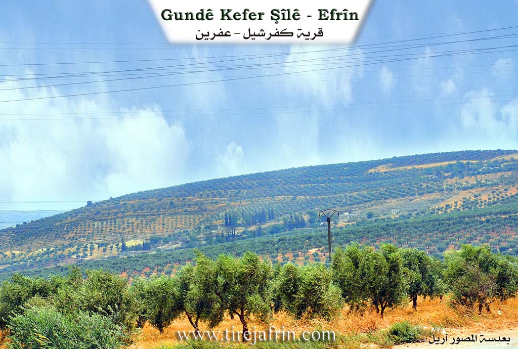
It is a large and prosperous village located on the southwestern slope of Çiyayê Keferşîl. To its west passes Geliyê Tizbiyê.
It is stated in the book Efrîn... Her River and Her Green Hills by the writer Ebdulrehman Mihemed from the village of Qetme: Keferşîl is a village in Çiyayê Kurmênc belonging to the sub-district of the villages of the center and area of Efrîn, Heleb governorate. It is a large village located on the lower southwestern slope of the limestone Çiyayê Keferşîl in the southeastern part of Çiyayê Heleb. To its west passes a valley where lands suitable for agriculture and rich in groundwater are abundant.
It is bordered to the north by a cultivated mountain height; to the south by a fertile agricultural plain planted with olive trees and the village of Bablît; to the west by a fertile plain, a mountain height, a valley, and the villages of Xelnêr and Maratê; and to the east by a wide, agriculturally fertile plain and the nearby city of Efrîn.
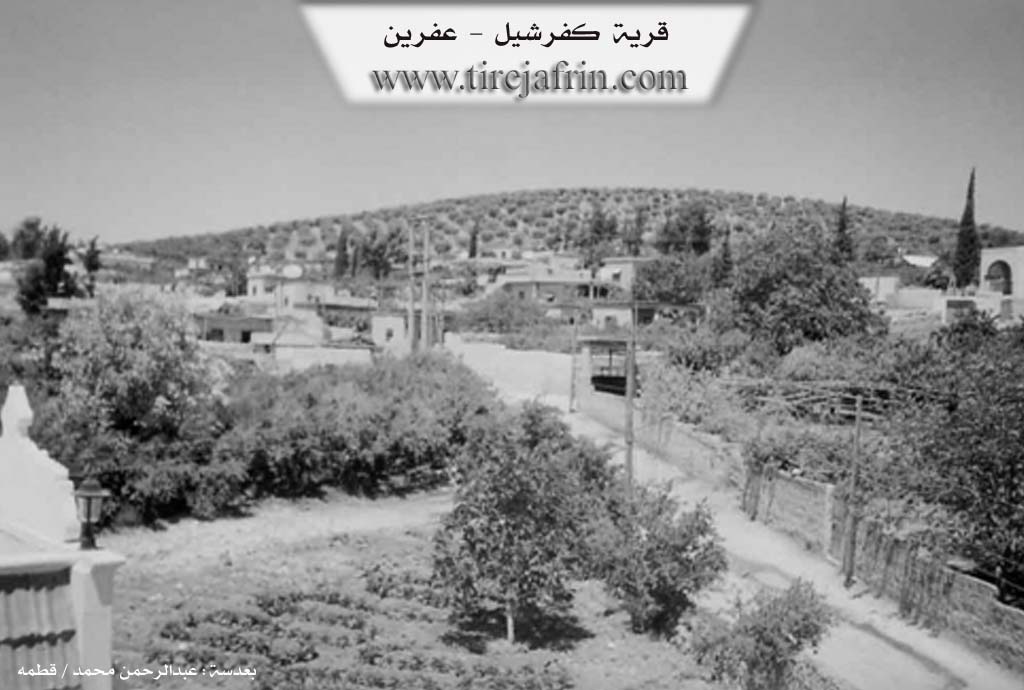
The number of its houses reaches about 75 houses, and its age is about 300 years. Its dwellings are of stone and mud with wooden roofs, and the modern ones are of reinforced concrete and stone. This village is one of the beautiful villages due to the abundance of pomegranate, walnut, and apricot trees. An electricity network is available, as well as drinking water from Bîra Maratê, a primary school, a telephone, a modern mosque, and a paved road that passes through the center of the village up to the village of Xelnêr.
The residents work in the cultivation of olives and other fruit trees and in raising sheep. Its lands are fertile and suitable for agriculture, and its soil is red. The village is surrounded on three sides, except the northern one, by a wide plain extending up to the city of Efrîn and the villages of Maratê and Xelnêr.
Among the families present in the village are: Ciqillî family, Xelbaş family (from the Şikak tribe belonging to the Şeran sub-district), and Misto family. The mukhtar of the village is Mr. Ebû Ebdo Miste. Also mentioned is Engineer Mistefa Mihemed Hac Mehmûd, holder of a PhD in Engineering.
Village Mukhtar: Umer Mihemed
Sources
Book: جبل الكرد (عفرين) دراسة جغرافية Çiyayê Kurmênc (Efrîn): A Geographical Study by د. محمد عبدو علي Dr. Mihemed Ebdo Elî.
Book: عفرين .... نهرها وروابيها الخضراء Efrîn... Her River and Her Green Hills by عبدالرحمن محمد Ebdulrehman Mihemed from the village of Qetme.
Preparation and Execution:
Director of Tirej Efrîn site: Ebdulrehman Hacî Osman
20/12/2013
II. Summary of Keferşîlê from Ax û Welat
Source: https://www.youtube.com/watch?v=v_gaLAJw-E8
History and Origins
The village of Keferşîl is located approximately three kilometers west of Efrîn. Its name is interpreted to mean "Baxçê şîlan" (Garden of wild roses). The site has deep historical roots; it is believed to have been a military post as far back as the era of the Mîtaniyan (Mitanni) due to the presence of ancient traces. The modern settlement, however, dates back approximately 250 to 400 years. According to village elder Ebdurehman, the area was inhabited about 70 years prior to the arrival of the current population by the Malê Kuleh, who originally came from Şorbe. These previous inhabitants eventually left, paving the way for the current families to settle.
Social Structure and Migration
The village is a mosaic of different lineages that have lived together for centuries. The Reşwanî tribe was the first to settle the land. They were followed by the Malê Cimo family, and subsequently the Sêjarazî (also referred to as Xelîl Sêjarazî). Other families include Malê Ehmed Sîdo (also known by the nickname Malê Memê, described as şêxîn or sheikhs) and Malê Qirik.
A voiceover in the documentary identifies four primary families currently constituting the village's core social structure: Çeqelî, Mistê Osê, Silêman, and Sêjarazî. Despite these distinct origins, the residents emphasize a strong sense of unity, stating that they no longer distinguish between families and act as a single entity. The village currently consists of approximately 80 households. It is noted for a high level of education, with around 50 graduates from universities and institutes, largely due to the village's proximity to Efrîn.
Economy and Landscape
Geographically, Keferşîl overlooks the vast Deşta Çiflikê and is backed by the heights of Reşwanên Maratê and Xelnêre. While the economy is now dominated by olive and pomegranate cultivation, the village has a rich viticultural history. An elder named Sebrî explains that centuries ago, the entire region, specifically between Keferşîl and Xanêre, was covered in vineyards (rez). He describes an ancient grape press, the Me'sera tir, located in the village, which dates back to at least 250 years ago. In the past, this site was used to produce molasses (dimis) and fruit leather (bastêq). Over time, the vineyards were replaced by olive groves and other fruit trees.
Traditions and Daily Life
The documentary highlights the preservation of communal traditions, particularly during the Ramadan holiday. Villagers engage in the preparation of Kumba, a traditional pastry spiced with sesame, cinnamon, and fennel. A distinct custom of Keferşîl is the communal holiday meal; historically, families would bring their food to the center of the village to eat together in a long line, a practice elders recall with nostalgia. The villagers also maintain the tradition of visiting the cemetery at dawn on Eid to pay respects to their ancestors and martyrs.
II. Summary of Keferşîlê from Multi Channel
The village of Kefer Şîl derives its name from a Syriac term meaning the farm of Şîl. The original settlement known as Kefer Şîl El Qedîme was an ancient Roman village located two kilometers south of the current location. It once featured two churches, historical wells, water channels, and a central spring. After being destroyed by earthquakes and volcanic activity, the surviving inhabitants moved north and initially took shelter in local caves. Over time, they built the modern village. The oldest surviving house in the new village belongs to the Mistefa Osman family and bears an inscription dating it to the year 1220 Hijri.
Historically, the area was settled by Kurdish families who had previously lived in the caves of nearby Xilnêr. Two brothers named Silêman and Mistefa from the Ciqilî branch of the Reşwan tribe were among the primary founders of the new village, moving there to seek better grazing lands for their livestock. As the village grew, other families arrived through intermarriage, including the Xelîl Sîcrazî family, who are also known locally as the Hefîdîye. Eventually, members of the Şîkak and Koçer tribes also settled in the area. The region additionally hosted nomadic Arab shepherds from the Umeyrat tribe. These shepherds worked in agriculture and grazing alongside the locals, leading to intermarriage and some families registering on the village civil records.
The villagers have historically maintained strong social and administrative ties with Efrîn, Maibetlî, Şeran, Kilis, and neighboring villages such as Bablît, Xilnêr, and Meerate. Today, Kefer Şîl is known for its peaceful community and high educational standards, though residents primarily rely on cultivating olives, pomegranates, and grain. Due to the ongoing conflict in Syria, the village has also become a refuge for internally displaced persons, such as the Eş Şehûd family from El Meera Eş Şerqî and others from Benî Zeyd in Heleb.
The residents of Kefer Şîl are known for their unique communal customs. The local historian Mihemed Silêman and the village mukhtar Ebû Îmad detailed rich historical traditions. During periods of drought, the community would gather at a sacred site known simply as the Zîyare. They would bring sheep to sacrifice, dance to the beat of drums, and share a large communal meal while praying for rain. During lunar eclipses, villagers believed a mythical whale was swallowing the moon, prompting them to beat drums and shoot firearms into the sky to frighten the creature away. Before the days of Eid, the men of the village practiced a custom called the charity of the dead, gathering in the village square to share a massive feast composed of dishes brought by every household.
The spirit of cooperation extended to weddings and funerals, where the entire village would contribute money to alleviate the financial burden on individual families. Notable residents interviewed include Beşîr Elî Cemo, Ebdilrehman Cemo, and the elderly Cume Ebdo, who shared memories of a peaceful past and sang a traditional song expressing the sorrows of displacement and changing times.
Transcriptions and Subtitles
| Source | Video | Subtitles | Transcript |
|---|---|---|---|
| Ax û Welat 1 | Watch Video | Download SRT | View Transcript |
| Multi Channel 1 | Watch Video | Download SRT | View Transcript |
Foundation/Origin Information of Keferşîlê
Established on a large hill with ancient ruins. Inhabited in ancient times by Kurds, it later served as an Ottoman military base. Before the current inhabitants, the Kelaho family from Şorbe settled it for 70 years. Current population descends from clans that arrived sequentially: first Reşwanî (Çeqelî), then Cimo, Xelîl Şêx Razi, and Ehmed Sîdo families.
Source: Ax û Walat Transcript
Possible Village Name Meaning of Keferşîlê
Kurdish "Şîle" means grape juice before it ferments. Another opinion is from Aramaic meaning "village of the cracked" or "son of the adulteress."
Source: TirejAfrin Site
The name means "garden of plums" (baxçê şîlan).
Source: Ax û Walat Transcript
V. Links
- Tirej Afrin:
https://www.tirejafrin.com/site/kura%20afrin%20markaz-%20kefershil.htm - Ax û Welat:
https://www.youtube.com/watch?v=kqTu2LffvzQ - Jawlat:
https://www.youtube.com/watch?v=G-xUDfRwxH8 - Drone video:
https://www.youtube.com/watch?v=MgFuVTBWcyQ - Link:
https://www.youtube.com/watch?v=GBZ4qDfVrIg - Link:
https://www.youtube.com/watch?v=ZTGPFr3WXcc - Link:
https://www.youtube.com/watch?v=UoQ9q2qQX4w - Video:
https://www.youtube.com/watch?v=eEz9SVHan18 - Link:
https://www.youtube.com/watch?v=zGXTjDiskAI - Link:
https://www.youtube.com/watch?v=dV_zyY003po - Link:
https://www.youtube.com/watch?v=7M_QNlqBbC0 - Ax û Welat:
https://www.youtube.com/watch?v=v_gaLAJw-E8