General Information
Nahiya (Subdistrict)
Şera
Also Known As
Keferom, Keferomê, كفر روم
Families, Clans, etc.
Ednan Axa, Ehmedî Toxtel, Mala Ebdî Hemê, Mala Heltopê, Mala Xelîl, Mala Şa'bo, Reşîd Axa, Zekî Axa, Şewket, Şêx Ismaîl Zade (Kûr Reşîd)

Photos
Basic Information about Keferomê
Source: Tirej Afrin
Etymology: Believed to be Greek-Syriac meaning 'Farm of the Romans' or Aramaic meaning 'Village of the Height' (Kefer = village, Rûm = height)
Foundation Date/Period: 300 years
Summaries
I. Summary from TirejAfrin Site (English) of Keferomê
Source: https://www.tirejafrin.com/site/kura%20afrin%20%20sheran%20-%20kafr%20rom.htm
Based on the book Çiyayê Kurmênc (Efrîn): A Geographical Study: Keferrûm / 705 inhabitants - 352m altitude - 8km.
Etymology and Name
Keferrûm: It is believed to be a Greek-Syriac name meaning "Farm of the Romans." However, Xurî Bersûm says it is Aramaic, meaning "Village of the Height," and this is likely correct as the village is situated on a high cliff on the eastern bank of the Efrîn river.
Location and Geography
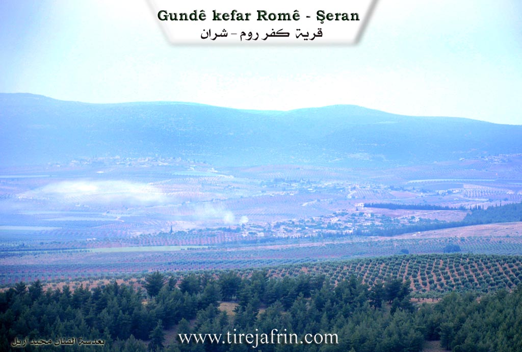
It is a medium-sized village located on the southwestern slope of a plateau, west on the Efrîn river. The village was among the properties of the well-known Agha Kûr Reşîd Şêx Ismaîl Zade, who resides there.
According to the book Efrîn... Her River and Her Green Hills: Keferrûm is a village in Çiyayê Kurmênc following the Şeran sub-district, Efrîn area, Heleb governorate (682 inhabitants). It is a small village situated in the northern part of Çiyayê Semen (Mount Simeon) on the southwestern slope of a limestone plateau and near the Efrîn river from the eastern side. It is 8km away from the town of Şeran towards the southwest.
Boundaries
It is bordered to the north by a mountain range, the Efrîn river valley, and the village of Hulubiya Biçûk. To the south by a slope, a deep valley, the course of the Efrîn river, a plain of olive trees, and the villages of Eyn Hecerê Mezin and Estêr. To the west by the course of the Efrîn river, a wide plain, the village of Eyn Hecerê Mezin, a deep valley, a mountain range planted with forest trees and olives, and the village of Qurtqulaqa Mezin.
Infrastructure and Housing
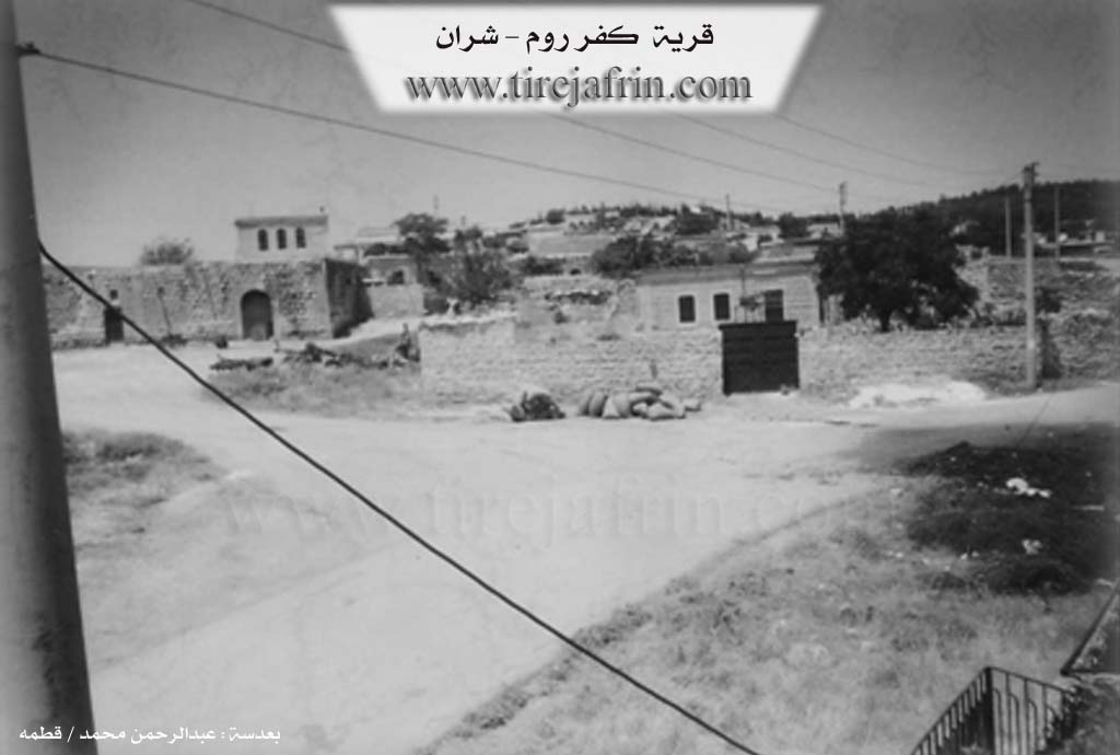
The number of its houses reaches 50, and its age is 300 years. An electricity network is available. Regarding drinking water, the residents drink from artesian wells and water collection cisterns. It has a primary school, and the paved road reaches the center of the village. Its old dwellings are of mud and stone with wooden roofs, surrounded by modern concrete houses expanding specifically towards the northeast along the public road.
Agriculture and Economy
The residents work in rain-fed agriculture (grains and olives) and in irrigated agriculture from the Efrîn river, such as vegetables, fruit trees, and fruits. It is a village with a beautiful location given its proximity to the Efrîn river.
Families and Social Structure
Among its most important old families is the Şêx Ismaîl Zade (Kûr Reşîd) family, for they are the real owners of the village.
Administration
Village Mukhtar: Mihemed Henan.
Sources
Book: جبل الكرد (عفرين) دراسة جغرافية Çiyayê Kurmênc (Efrîn): A Geographical Study by د. محمد عبدو علي Dr. Mihemed Ebdo Elî.
Book: عفرين .... نهرها وروابيها الخضراء Efrîn... Her River and Her Green Hills by عبدالرحمن محمد Ebdulrehman Mihemed from the village of Qetme.
Studies of Navenda Tirej Soft / Ebdulrehman Hacî Osman.
Some residents of the villages.
Preparation and Execution: Manager of Tirej Efrîn site: Ebdulrehman Hacî Osman 20/12/2013
II. Summary of Keferomê from Ax û Welat
The documentary explores the historical and cultural landscape of Kefer Rûmê, a village located eleven kilometers northeast of Efrîn. The village is centuries old and forms a close community alongside neighboring settlements like Gemrûkê, Qirtqulaq, and Eilkê. The local mukhtar, Bavê Remzî, has held his position since nineteen eighty six. He inherited this unpaid role of service from his uncle, who in turn inherited it from his father and grandfather.
Historically, the village has endured significant regional shifts. Bavê Remzî points out an old abandoned house originally built by a man named Xelîl. Xelîl was conscripted into the army of Elî Osmaniyan, referring to the Ottoman Turkish state, and fell as a martyr, leaving no descendants behind. Following this period, the government of the Fransizan arrived in nineteen twenty one.
The social structure of Kefer Rûmê revolves around four primary families. These are Mala Heltopê, Mala Xelîl, Mala Şa'bo, and Mala Ebdî Hemê. They maintain a highly egalitarian and cooperative community, sharing in both joyous occasions and times of mourning.
Agriculture forms the backbone of the village economy, heavily supported by the abundant waters of Ava Efrînê. Farmers such as Behrî, Ehnter, Elî Berazî, and Henan cultivate the fertile lands along the riverbanks. They meticulously prepare the soil starting in April, growing crops like wheat, watermelons, zucchini, peaches, peppers, and tomatoes. The farmers utilize a combination of river water and upper canal irrigation to sustain their fields.
Cultural traditions remain deeply ingrained in the community. Elder women reminisce about traditional weddings, contrasting modern salon celebrations with older customs that involved open air gatherings, def drums, henna ceremonies, and communal feasts. Culinary heritage is also preserved through the preparation of Gililok, a traditional dish made from fine bulgur, meat, garlic, and cumin, which is then cooked in buttermilk. During a night gathering at Kampa Berxwedan, a woman recites a poignant poem about freedom, referencing figures and places like Apê Xoce, Îmralî, Botan, Qendîl, and Zînebê.
The vibrant musical culture of Kefer Rûmê is showcased during a village wedding. Local musicians Ehmedê Xanî, Simo Bavê Memû, and Xelîl Evîndar perform authentic traditional songs. A highlight is the tragic love song Hêycan, which narrates a story of a poor lover seeking remedies in Helebê and Entabê, and traveling through Cûmiyê and Qesteliyê. Through its rich history, agriculture, and enduring traditions, Kefer Rûmê stands as a testament to the resilient spirit of the region.
II. Summary of Keferomê from Afrin 366
Source: https://www.youtube.com/watch?v=VeKFjvh8FiI
The documentary explores the village of Kefer Rûm located in the Şera district within the Çiyayê Kurmênc region. When discussing the origins of the name Kefer Rûm, a local resident named Ebo Beşar notes that the exact meaning is unknown, though both he and the host speculate it might originate from the Rûm having lived in the area in ancient times. The village does not have a specific foundation date mentioned in the transcript.
Historically and socially, Kefer Rûm is a small but tight knit community originally comprising around one hundred homes, with approximately seventy to eighty currently occupied. The village is completely Kurd by origin and is divided into an upper neighborhood known as Heretî Eltopo and a lower neighborhood. Despite this geographic division, the residents maintain a strong, unified bond without any social fragmentation. The original landowning families are prominent in the village, specifically the Reşîd Axa, Zekî Axa, and Ednan Axa lineages. Later in the documentary, the Şewket and Ehmedî Toxtel families are also pointed out by locals.
The demographic landscape of Kefer Rûm has experienced recent changes due to regional instability and the resulting displacement of populations. While the native inhabitants are Kurd, a large number of displaced Arab families from eastern regions such as Tebqa and Reqqê, alongside Kurdish displaced persons from the Şêx Meqsûd neighborhood, have settled in the vicinity. Humanitarian organizations have constructed formalized concrete shelters and tent camps in the area to house these newcomers. The region also hosts Arab pastoralists who tend to flocks of sheep in the uncultivated areas around neighboring settlements like Badîno. Fortunately, residents note that Kefer Rûm itself was spared from the severe destruction of the recent earthquake that heavily damaged other districts like Bilbil.
The area surrounding Kefer Rûm features diverse geography with deep valleys and lush natural resources, bordered by other localities including Gamrûk, Şorbe, Eyn Hecerê, Alkê, Dimilyo, and Metîna. Although there are no specific shrines mentioned, an ancient stone olive press remains as a testament to the long history of agriculture in the region. The village is renowned for its fertile lands and relies heavily on agriculture. The locals cultivate wheat, barley, almonds, figs, and olives. Despite the abundant natural beauty and productive lands, the village currently lacks foundational public services, such as electricity networks and running water, forcing residents to rely on private wells. Furthermore, there is no bakery in the village, so bread must be brought in daily from nearby Şera and Kefer Cenê.
Transcriptions and Subtitles
| Source | Video | Subtitles | Transcript |
|---|---|---|---|
| Afrin 366 1 | Watch Video | Download SRT | View Transcript |
| Ax û Welat 1 | Watch Video | Download SRT | View Transcript |
Foundation/Origin Information of Keferomê
It was among the properties of the well-known Agha "Kor Rashid Sheikh Ismail Zadeh" who lived there.
Source: TirejAfrin Site
Possible Village Name Meaning of Keferomê
Believed to be a Greek-Syriac name meaning "farm of the Romans," or Aramaic meaning "village of elevation."
Source: TirejAfrin Site
V. Links
- Tirej Afrin:
https://www.tirejafrin.com/site/kura%20afrin%20%20sheran%20-%20kafr%20rom.htm - Video:
https://www.youtube.com/watch?v=iXe3B42OwAU - Link:
https://www.youtube.com/watch?v=ovXKYAj9x2c - Link:
https://www.youtube.com/watch?v=k3s29J2etpw - Link:
https://www.youtube.com/watch?v=cySdY0bK2SU - Ax û Welat:
https://www.youtube.com/watch?v=c9rYeiTGq6A - Afrin 366:
https://www.youtube.com/watch?v=VeKFjvh8FiI