General Information
Nahiya (Subdistrict)
Cindires
Also Known As
Kefer Safra, Kefer Sefrê, Kefersefrê, Kefirsefrê, كفر صفره, كفرصفرة
Families, Clans, etc.
Elî Şêr, Hac Ebdo, Hacî, Izîd Xelo, Mem, Mirad, Qudrêş, Xolû

Photos

Basic Information about Kefersefrê
Source: Ax û Welat
Foundation Date/Period: 300 years ago
Hills: çiyayê Şêx Mihemed
Shrines: Şêx Mihemed, Goristana Şehîd Seydo
Ruins: şikest
Wells: Bîrê Rikê
Other Landmarks: Tetera, Kûra, Alanqûzê
Source: Afrin 366
Trees: Qorix
Other Landmarks: Tetera
Summaries
I. Summary from TirejAfrin Site (English) of Kefersefrê
Source: https://www.tirejafrin.com/site/kura%20afrin%20Cindires%20-kefersefre.htm
It is stated in the book جبل الكرد (عفرين) دراسة جغرافية Çiyayê Kurmênc (Efrîn): A Geographical Study by د. محمد عبدو علي Dr. Mihemed Ebdo Elî: Kefersefr, Kefersefrê /4121 inhabitants - 1320 AH - 5km - 400m/:
Father Şelhet says that "Sefra" in Aramaic means: Morning or Sparrow, meaning the village of the Morning or the Sparrow (Reference: El Esedî, Vol 6, p 377). And perhaps it is otherwise.
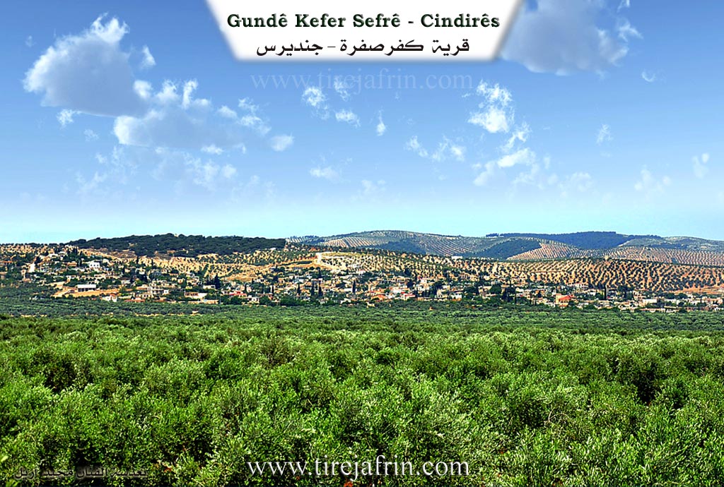
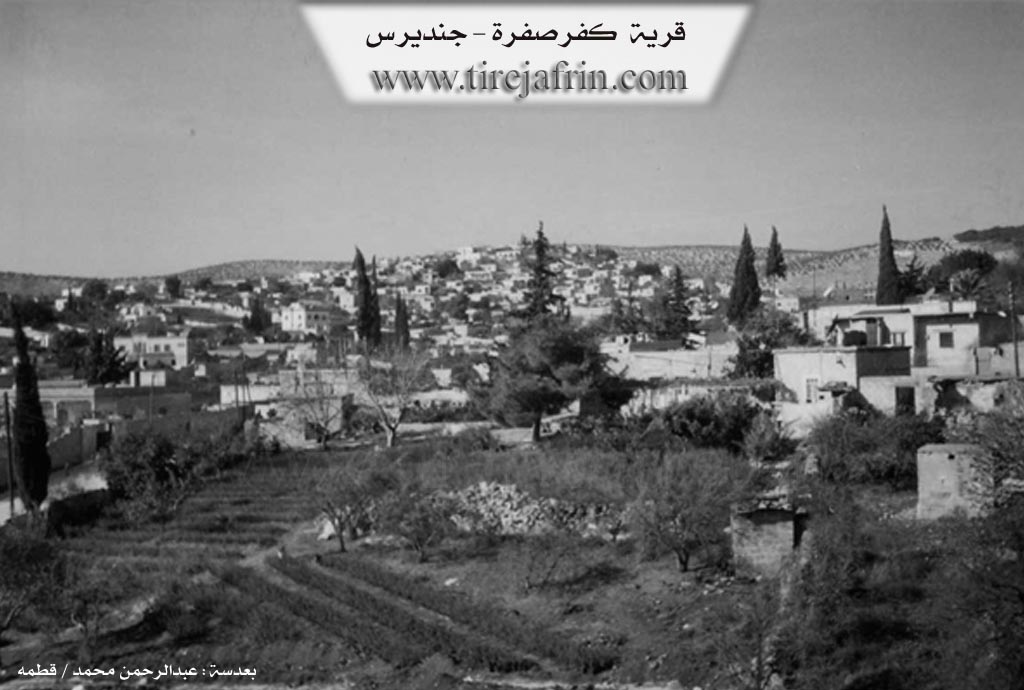
It is located on the southern slope of Çiyayê Qaziqli, overlooking the olive fields extending south to the town of Cindirês. A valley divides it into two halves. It is one of the large villages in the Cindirês district. It contains a large Aga family. Its houses are spread on the slopes, and it contains beautiful villas.
It is stated in the book: عفرين .... نهرها وروابيها الخضراء Efrîn... Her River and Her Green Hills by the writer عبدالرحمن محمد Ebdulrehman Mihemed from the village of Qetme: Kefersefrê is a village in Çiyayê Kurmênc, administratively belonging to the Cindirês district of the Efrîn region, Heleb governorate.
It is a large village located at the end of the southern slope of the Çiyayê Kurmênc massif. It is approximately 5km away from the town of Cindirês. To the north and west, it overlooks fertile agricultural lands in the eastern part of the Cindirês plain. Several descending watercourses meet from its north to form Geliyê Nîzam (Valley of Nizam), which penetrates the village.
It is bordered to the north by mountain heights planted with olive trees and forest trees, and the village of Teteran; to the south, it overlooks a wide, agriculturally fertile plain planted with olive and pomegranate trees, the village of Yalanqoz, and the village of Baflûr; to the west, a fertile agricultural plain and some mountain heights planted with olive and forest trees, the village of Aşkan Xerbî, and Merwanê Jorîn; and to the east, a fertile plain planted with olive trees, the village of Kumuşburc, the village of Rindikan, and Koran.
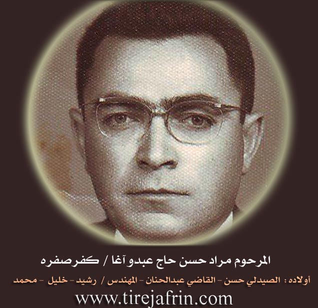
The number of its houses is approximately 450, and its age is approximately 600 years. Its old houses are of stone and mud with flat wooden roofs, while the modern ones are cement. It has an electricity network and water from an artesian well located in the south. It has several primary and preparatory schools, a telephone center, and a mosque in the center of the village. A municipality building was also established there recently. Additionally, there are modern olive presses and several luxurious houses located in its center belonging to the Hac Ebdo and Mirad Hac Ebdo families and others.
Kefersefrê is considered one of the old and large villages in the Efrîn region, Cindirês district. Most of its residents work in the cultivation of olives, legumes, and grains through rain-fed farming, as well as pomegranates and vegetables through irrigation from artesian wells, alongside raising sheep and goats. There are several modern villas at the entrance of the village from the southern side. Furthermore, the road connecting it with the district and the region is paved up to the center of the village.
Among its most important families (the old residents of the village): the Hac Ebdo family, the Hacî family, and the Mirad family. The first school built in the Cûm district and Cindirês currently was in the village of Kefersefrê, dating back to 1930 AD.
Among the cultural figures in the village: Mr. Hesen Xelîl \ Temûz Şemalî.
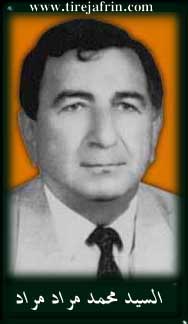
Among the sons of this village: Judge Ebdulhenan Hac Ebdo and Engineer Nebî Mirad.
Mukhtar of the village: Nebîh Mirad Mirad.
Preparation and execution:
Manager of Tirej Efrîn site: Ebdulrehman Hacî Osman
20/12/2013
Sources:
- Book: جبل الكرد (عفرين) دراسة جغرافية Çiyayê Kurmênc (Efrîn): A Geographical Study by د. محمد عبدو علي Dr. Mihemed Ebdo Elî.
- Book: عفرين .... نهرها وروابيها الخضراء Efrîn... Her River and Her Green Hills by عبدالرحمن محمد Ebdulrehman Mihemed from the village of Qetme.
II. Summary of Kefersefrê from Ax û Welat
Source: https://www.youtube.com/watch?v=FKloSj-9ObE
The village of Kefer Sefrê, located in the Cindirêsê district about four kilometers from the town center, was established approximately 300 years ago. Its origins are traced back to two Êzîdî brothers named Izîd Xelo and Mem. According to local oral history, these brothers worked for a noblewoman referred to as the xatûn in Cindirêsê. When raiders stole the lady's livestock, the brothers joined her guards in pursuit. They intercepted the thieves at a well named Bîrê Rikê, located near the village of Kûra. A skirmish ensued where the bandit leader, Ba Dirle Xelo, was killed. The brothers successfully recovered the livestock and returned them to the xatûn. Impressed by their bravery and integrity, she granted them a vast tract of land stretching from Cindirêsê to Tetera.
Initially, the land was covered in dense brush and wild trees. The early settlers lived in ancient rock cut dwellings known as şikest, which villagers attribute to the Roman era. Over time, the settlement expanded significantly. One brother's lineage eventually moved to Alanqûzê and another to Tetera, while the core village of Kefer Sefrê grew to encompass around 600 households. The population is comprised of descendants of these founders and other families who later arrived from Xêrî, Alanqûzê, and Tetera.
Agriculture defines the modern identity of Kefer Sefrê. While originally wild terrain, generations of residents cleared the land to plant olive trees. A significant agricultural shift occurred in the 1990s when an engineer named Ehmed Hacî introduced a grafting technique called qelem for olive saplings. This innovation made the village famous throughout the region for its olive cultivation. Residents also grow pomegranates, citrus fruits, pistachios, and decorative trees like the darê zînê.
The village contains important spiritual and commemorative sites. The most ancient is the shrine of Şêx Mihemed, located on çiyayê Şêx Mihemed. This site predates the village itself and serves as a place of prayer and gathering for the community. More recently, following the onset of the conflict in Syria, the village established the Goristana Şehîd Seydo, a cemetery dedicated to local martyrs. It holds the graves of fighters such as Şehîd Seydo, Şehîd Kemal, Şehîd Elî, and Şehîd Çekdar.
Culturally, the village preserves specific culinary and musical traditions. Locals prepare a regional dish called şûrbeya dên (known elsewhere as Keledoş) and a special sesame bread called nanê bi zilmekuncî. The village is also home to traditional musicians like Apê Hemo, a zurna player who performed for decades alongside notable regional artists.
II. Summary of Kefersefrê from Afrin 366
Source: https://www.youtube.com/watch?v=hI_OJJWznJs
The village of Kefer Sefrê is located approximately five kilometers from the town of Cindirêsê in the Afrin region. It is a large and historically rooted settlement known for its extensive olive groves and a high level of education among its residents. The village landscape includes both modern constructions and older traditional courtyards called "hewş" alongside a wooded area referred to as Qorix.
According to the village elder and retired teacher Memrez Xolû, the history of Kefer Sefrê dates back specifically to the year 37 AD, described in the text as "Sala sî û hefta mîladî". The elder recounts a local account regarding the village's origins involving two individuals described as "hacî" or pilgrims who were soldiers from Cindirêsê. One of these founders was named Zêdber. Xolû notes that the name Zêdber was associated with being "qicik" or small in stature and links the origin to a time when the population was very limited.
The social structure of Kefer Sefrê is defined by its families and a strong emphasis on academic learning. Notable lineages mentioned include the Xolû family, the Elî Şêr family, and the Qudrêş family. The village has a reputation for being culturally advanced with Xolû stating that the community is "pêşketî" or developed. He highlights that many generations including the current youth have attended universities. The village contains two mosques which expanded from a single original mosque and a school referred to as "mekteba".
Demographically the village has undergone significant changes. Historical census data remembered by the elders from the 1970s and 1980s placed the population at 1,203 people when counted together with the neighboring locality of Tetera. At the time of the documentary, the village physical infrastructure consists of approximately 800 houses known as "heşt sed mal". However, the resident population has decreased to roughly 400 or 450 people due to emigration.
The documentary highlights specific ancestral connections within the village. The host visits the "mala ceddê" or the ancestral home of the Elî Şêr family where the residents maintain the old stone structures and courtyards. The elder Xolû, who is eighty five years old, serves as the primary keeper of the village's oral history and statistics, preserving the memory of its foundation and its transformation over the centuries.
Transcriptions and Subtitles
| Source | Video | Subtitles | Transcript |
|---|---|---|---|
| Afrin 366 1 | Watch Video | Download SRT | View Transcript |
| Ax û Welat 1 | Watch Video | Download SRT | View Transcript |
Foundation/Origin Information of Kefersefrê
It is one of the ancient and large villages in the Jindires District.
Source: TirejAfrin Site
Founded by two Yazidi brothers, Îzîd Xalo and Mem, who were granted a large expanse of uncultivated land by a woman named Xatûn as a reward for defending her property from bandits.
Source: Ax û Walat Transcript
Possible Village Name Meaning of Kefersefrê
From Aramaic "Safra," meaning morning or sparrows, so the "village of morning" or "village of sparrows."
Source: TirejAfrin Site
V. Links
- Tirej Afrin:
https://www.tirejafrin.com/site/kura%20afrin%20Cindires%20-kefersefre.htm - Link:
https://www.facebook.com/ferid.hajabdo/posts/pfbid028r6AzADvxoSVWzGCiBX8E2xc1oB6n3Nz3iHkzf2Zp2SKq68fM7sabiMPPwq881cBl - Ax û Welat:
https://www.youtube.com/watch?v=FKloSj-9ObE - Local FB page:
https://www.facebook.com/profile.php?id=100063897603460 - Video:
https://www.youtube.com/watch?v=1KxdRg3jeVA - Link:
https://www.youtube.com/watch?v=GNVEYfGV5ng - Link:
https://www.youtube.com/watch?v=ImRqISvoc38 - Link:
https://www.youtube.com/watch?v=523htXXRpKY - Link:
https://www.youtube.com/watch?v=EzL686eFrZ8 - Afrin 366:
https://www.youtube.com/watch?v=hI_OJJWznJs