General Information
Nahiya (Subdistrict)
Bilbilê
Also Known As
Al-Mudallala, Kotana, Kotanli, المدللة, كوتانلي, كوتونه
Tribes
Mila, Qeraca, Şikaka
Families, Clans, etc.
Aslan, Brahîm, Cewherî, Gulcan, Hebîşa, Kursela, Mehmiçan, Mîran, Şêxo

Photos
Basic Information about Kotana
Source: Khalil Sino
Etymology: Derived from the phrase "Kûtê ana" (My mark is short/here), dating back to the Ottoman era when soldiers would identify the village Mukhtar by a specific mark (kût/deq).
Foundation Date/Period: Approximately 250 to 300 years ago
Number of Caves: 1
Hills: Qişle
Ruins: Qişle
Wells: bîra avzê
Other Landmarks: Bilbilê, Heleb
Summaries
I. Summary from TirejAfrin Site (English) of Kotana
Source: https://www.tirejafrin.com/site/kura%20afrin%20%20%20bilbile%20-%20Kotanle.htm
According to the book Çiyayê Kurmênc (Efrîn): A Geographical Study, the entry for Kotana Kotanlî al Mudallalah is as follows:
Population: 2356. Area: 703 hectares. Distance: 12km. Altitude: 560m.
Etymology and Name
Regarding Kotana, the last syllable "an" from the name Kotan is said to mean "Mother," and the first syllable "Kt" means "Lame" (Kut) in Kurdish. Thus, the name is a composite meaning "The Lame Mother." This "lame mother" was among the earliest inhabitants of the village, and the village was named after her. Some say, perhaps to annoy the villagers, that the mother was afflicted with smallpox (Kot), so she was known by her pockmarked face.
Location and Geography
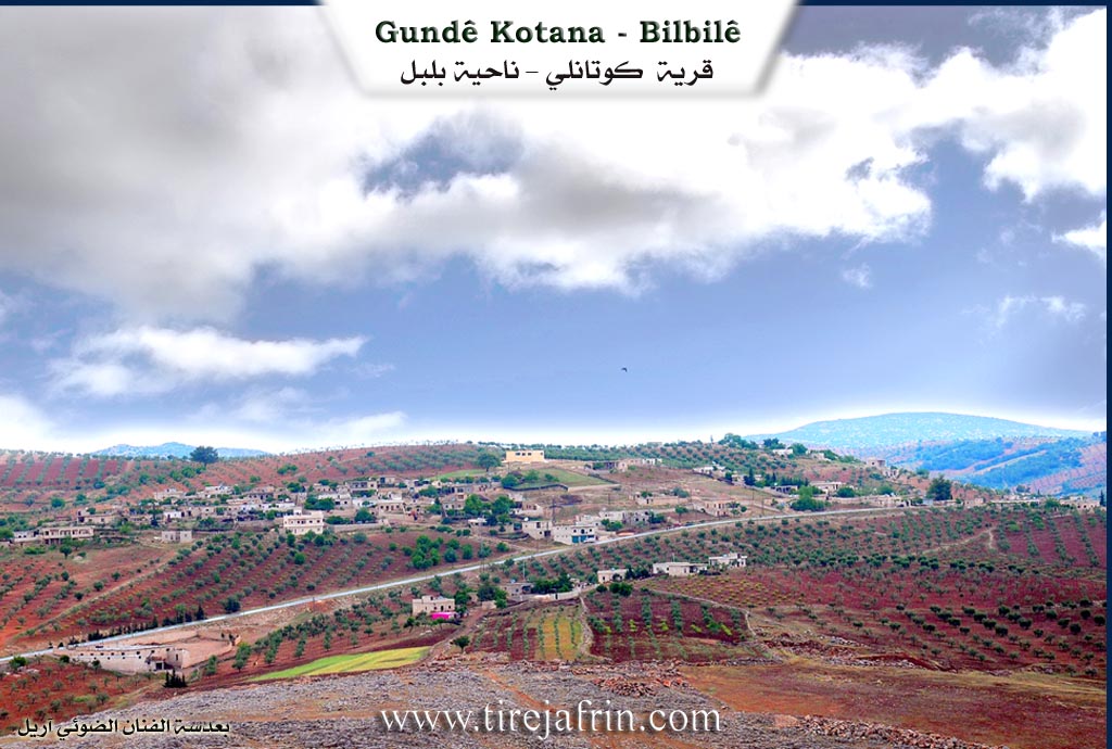
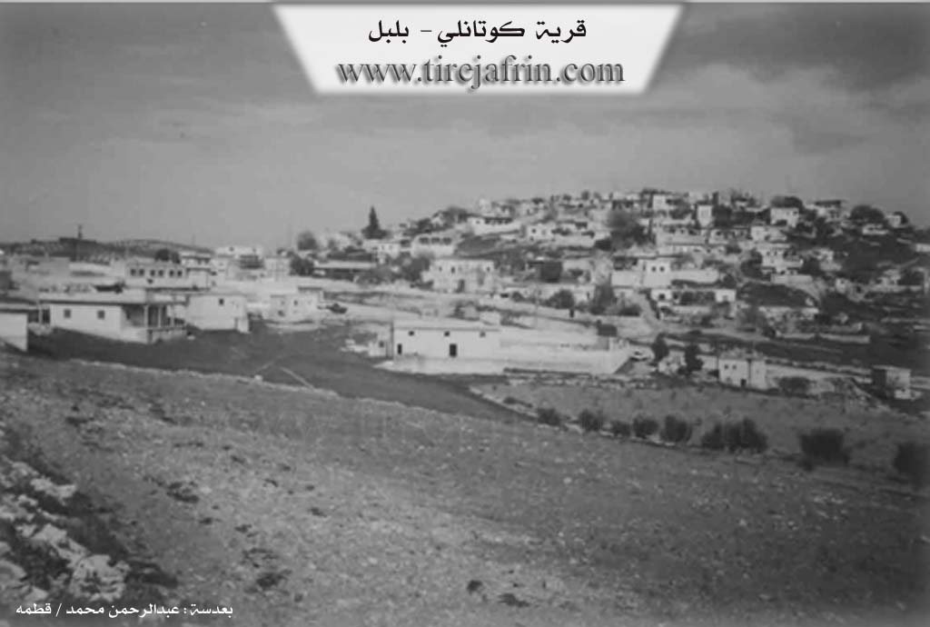
It is a large village consisting of two sections situated on two adjacent heights. One is in the east, which is the old village, and the other is in the west on the eastern slope of Çiyayê Upla. The paved road leading to Bilbile passes between them. From the east, the village overlooks Geliyê Şay (Shay Valley), which comes from the areas of Bilbile. Like most villages located on public roads, commercial shops and small vocational workshops have been established there. It was built on an ancient archaeological site due to the presence of archaeological stones within it.
Description from "Efrîn... Her River and Her Green Hills"
The book Efrîn... Her River and Her Green Hills describes Kotanlî as a village in Çiyayê Kurmênc following the township of Bilbile, in the Efrîn region of the Heleb governorate. It is a large and old village located on a rocky plateau on the lower, gently sloping eastern face of the limestone mountain Çiyayê Abîl Uşaxî. It is 12km away from the town of Bilbile towards the southeast.
Boundaries and Surroundings
The village overlooks its agricultural lands with clay soil to the west. It is bordered to the north by a mountainous height planted with olive trees and the village of Qurt Uşaxî. To the south, it is bordered by Geliyê Sêlê, a mountain range, and the village of Hesen Dêrlî. To the west, there is a mountain range planted with olive trees and the village of Abîl Uşaxî. To the east, it is bordered by Geliyê Sêlê, a high mountain range, and the villages of Bîlan Koy and Qizilbaş.
Architecture and Layout
The number of houses reaches approximately 350, and the village is about 500 years old. Its old dwellings are made of stone and mud with flat wooden roofs, while the modern ones are cement and have extended southward and to the outskirts. The village is divided into three sections: a very old section located on a high hill in the center of the village, and the other two sections on the sides of the Riya Bilbile Meydankê (Bilbile Meydankê road).
Local Tradition regarding the Name
When asking the people of the village about the reason for the naming, they refer to the meaning "Kute," which means "Lame," due to the arrival of a lame woman who lived in the village long ago and was married to one of the members of the small village at that time.
Services and Infrastructure
An electricity network is available in the village. The village drinks from a network connected to an artesian well on its western side. There is a primary and preparatory school, a telephone center, and a municipality was recently created; the municipality building was constructed at the first entrance to the town in 2005.
Economy
The residents work in rain fed agriculture, growing olives, vines, grains, and legumes on an area of 703 hectares, alongside raising sheep and goats. There is a modern olive press and a farmers' cooperative in the village. The Riya Bilbile (road to Bilbile town) is paved, passes through the center of the village, and connects to neighboring villages.
Notable Residents
The village Mukhtar is Ebdulmenan Mihemed.
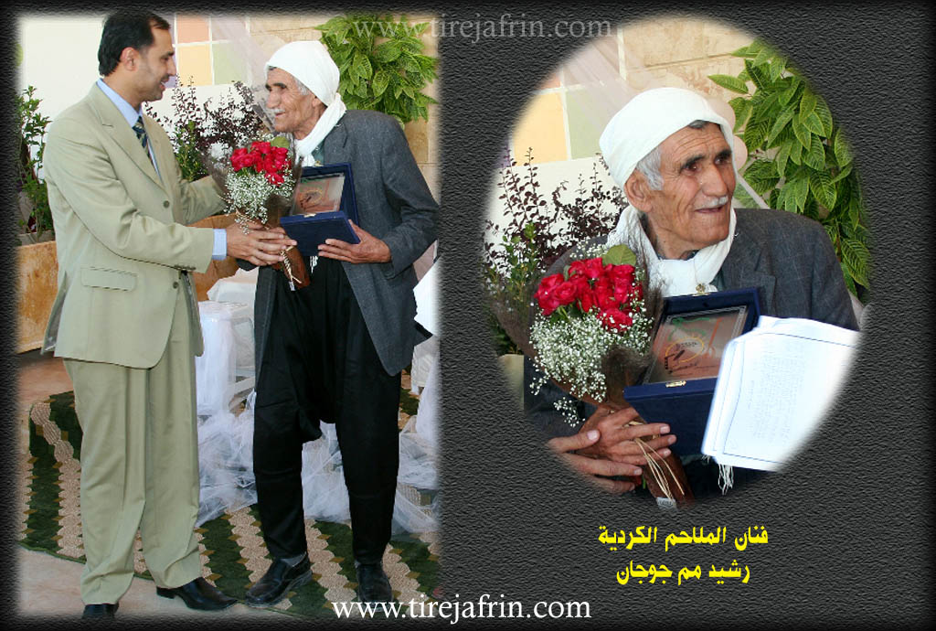
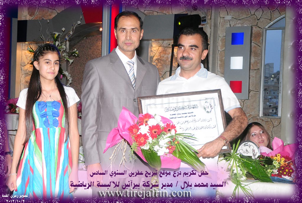
It is noted that the late artist Reşîd Mem Cûcane and the producer Mr. Mihemed Bilal, owner of the Pîranîn company, who contributed to supporting the annual Tirej Efrîn website shield ceremonies, are sons of this village.
Sources
Book: جبل الكرد (عفرين) دراسة جغرافية Çiyayê Kurmênc (Efrîn): A Geographical Study by د. محمد عبدو علي Dr. Mihemed Ebdo Elî.
Book: عفرين .... نهرها وروابيها الخضراء Efrîn... Her River and Her Green Hills by عبدالرحمن محمد Ebdulrehman Mihemed from the village of Qetme.
Studies of Navenda Tirej Soft / Ebdulrehman Hacî Osman.
Some residents of the villages.
Preparation and Execution: Director of Tirej Efrîn site: Ebdulrehman Hacî Osman 20/12/2013
II. Summary of Kotana from Khalil Sino
Source: https://www.youtube.com/watch?v=1Kpyfi977_A
The village of Kutanê (also referred to as Kûtana) is situated in the Bilbilê district of the Afrin region. According to the elder Abdulhemîd Şêxo, the village in its current location was established approximately 250 to 300 years ago. Originally, the community resided at a nearby site called Qişle. However, during the Ottoman era ("Hukmatê Ûsmolî"), the villagers faced pressure and raids ("mal basmiş dikirin"), forcing them to relocate to the top of a hill for better defense. The settlement began with four houses built in a defensive square formation, allowing them to protect their livestock in the center.
The name Kutanê is said to possess a unique etymological origin dating back to the Ottoman administration. Abdulhemîd Şêxo recounts that soldiers would visit the village headman (muxtar), who possessed a distinctive mark or characteristic referred to as a "kût." The phrase "Kûtê ana" (interpreted as "my mark is short" or referencing the mother) was used, eventually evolving into the name Kûtana.
Historically, the village economy relied heavily on agriculture, specifically vineyards and olives. In the past, the village housed three olive oil presses (ma'sere). The residents were also known for producing high-quality raisins (mûj) from their vineyards, particularly from the land known as 'ardê ssor. These goods were transported by mules to Heleb (Aleppo) for trade, often bartered for wheat ("heryê") rather than currency. Water sources were critical to daily life, with the community relying on a specific well named bîra avzê, where the water levels would fluctuate with the seasons.
Socially, the village is home to several families, including the Şêxo, Cewherî, Mehmiçan, Gulcan, and Brahîm families. One resident, Arifê Cewherî, notes that his lineage ("jil") originally came from Urfa before settling in the region. The village served as an educational hub for the surrounding area; a school established around 1958 drew students from neighboring villages such as Qizilbaş, Bêlê, Ehmedê Mistê, Qorugul, Xelîlako, Qeysem, and Meydanleg. Consequently, Kutanê is reputed for producing many educated professionals, including doctors and engineers.
Prominent figures mentioned in the village's history include Reşîd Mehmiçan, Zekeriya Gulcan, and Ehmed Efrînî. Current notable residents include the blacksmith Mihemed, who continues his father's trade, and the young footballer Ozan, mentioned by his mother Hanîfe. Despite the deep historical roots, the community currently faces the challenges of emigration, with many family members now living abroad in places like Germany and Ukraine, leaving elders to maintain the ancestral homes.
II. Summary of Kotana from Multi Channel
The village of Qotanê, also referred to locally as Kûtanan, is located in the Bilbilê district. According to local elders, the settlement was established approximately 300 years ago. The original founders lived in a smaller sparse settlement to the north but eventually relocated near the hill known as Serî Til. They brought their homes closer together to better defend themselves against thieves, organizing the village with central sheepfolds and three main access roads.
The village exhibits a deeply interconnected social structure. Prominent kinship groups and tribes include the Mila and Qeraca tribes, alongside the Hebîşa, Kursela, Şêxo, and Mîran families. While predominantly Kurdish, the village has also historically been home to a few Arab households.
Geographically and agriculturally, Qotanê transitioned over the years. Before modern wells, the villagers depended on deep ancient wells like Qirtûwazî, whose origins remain a mystery to the current residents. During dry seasons, residents would travel to the Qestelê Mixte spring with their pack animals to fetch water. The village economy relied heavily on dry farming, growing wheat, barley, and chickpeas. Over time, they planted vineyards in the Geliyê Çayê valley, cultivating specific grape varieties like Şêxî, Şamî, and Humsî, though olive groves eventually replaced most other fruit trees and vineyards.
The older generations preserve rich cultural traditions. Women were essential to the agrarian lifestyle, participating in the olive harvest and preparing traditional local foods such as Sermîsaq, Sarmet, and Şilik. Social gatherings were marked by multi day wedding celebrations with traditional instruments and communal storytelling, featuring renowned folktales like the legend of Şêxê Şeş.
Qotanê is exceptionally well regarded in the region for its dedication to education. Formal schooling began robustly around 1970 after a local man named Ebdulmenan Îbrahîm successfully lobbied the authorities in Cindirêsê. As a result, the village became an educational hub, eventually hosting a secondary school that serves neighboring villages like Qizilbaş and Xelîlako. The community has produced hundreds of educated professionals, many of whom went on to work in Heleb and beyond.
The village is also a center of artistic expression. A local musician named Aslan Salih, who adopted the stage name Aslan Şêr while performing with Koma Stêrê, is a celebrated voice in the community. Inspired by classic singers like Reşîdê Mihemed Çoçan and Zekeriya Diljan, his music reflects the cultural heartbeat of the region. His original songs, as well as classic folkloric tracks mentioning regions like Çiyayê Kurda and tribes like the Şikaka, invoke a deep longing to rebuild and celebrate their homeland.
Transcriptions and Subtitles
| Source | Video | Subtitles | Transcript |
|---|---|---|---|
| Khalil Sino 1 | Watch Video | Download SRT | View Transcript |
| Multi Channel 1 | Watch Video | Download SRT | View Transcript |
Foundation/Origin Information of Kotana
An ancient village built on an archaeological site.
Source: TirejAfrin Site
Originally founded on a nearby hill known as "Qishla" by four families seeking refuge from the Ottoman government, which was seizing property. They built their homes in a defensive formation.
Source: Halil Sino Transcript
Possible Village Name Meaning of Kotana
The final syllable -an from the name Kotan means "mother," and the first syllable Kût means "lame" in Kurdish, so the compound name means "the lame mother," who was among the first inhabitants of the village.
Source: TirejAfrin Site
Originated from an encounter between Ottoman soldiers and the deaf mother of the local mukhtar, who responded "Küt Ana" (deaf mother).
Source: Halil Sino Transcript
V. Links
- Tirej Afrin:
https://www.tirejafrin.com/site/kura%20afrin%20%20%20bilbile%20-%20Kotanle.htm - Local FB page:
https://www.facebook.com/profile.php?id=100080661844103 - Video:
https://www.youtube.com/watch?v=4UjibPt6Tro - Link:
https://www.youtube.com/watch?v=RHENlrxArGg - Khalil Sino:
https://www.youtube.com/watch?v=1Kpyfi977_A - Multi Channel:
https://youtu.be/dOxzdJ27Ssg?si=47wZyuUHlK9HEdDG