General Information
Nahiya (Subdistrict)
Reco
Also Known As
Maseka, Masika, Masikan, Maskanli, Mûsako, Mûsakê, ماسكانلي, ماسيكان, موساكو
Tribes
Maseka
Families, Clans, etc.
Bekir Ce'don, Bildirêjê, Cabro, Dirdê, Ekaşî Qapê, Elî Qere, Hecî Şiketko, Hewîdî, Kenîn, Mala Bekir Cadan, Mala Bildirêjê, Mala Durdu, Mala Ecko şeqe pî, Mala Elî Qere, Mala Hecî Şikeftka, Mala Hevidî, Mala Kenîn, Mala Mistik Xedê, Mala Misî Yûsiv, Mala Şêxê Bilkê, Mistê Xedê, Mîso Yisiv, Mûsa, Qabe, Qere, Xadînan, Şêxî Bilkê

Photos
Basic Information about Maseka
Source: Ax û Welat
Foundation Date/Period: 400 years ago
Ruins: Barcûq
Trees: Dara Mirazan
Wells: Bîra Barcûq
Other Landmarks: Kevirê Kuxikê, Riya Hesin, Tunela trênê
Summaries
I. Summary from TirejAfrin Site (English) of Maseka
It is stated in the book جبل الكرد (عفرين) دراسة جغرافية Çiyayê Kurmênc (Efrîn): A Geographical Study: Maseka, Masekanlî, Masîkan / 2068 inhabitants, 166 hectares, 2km, 620m /:
Maseka: The name of a Kurdish tribe found in Botan (Lerx, p. 48). Şerefxan mentions it in the form of "Masik".
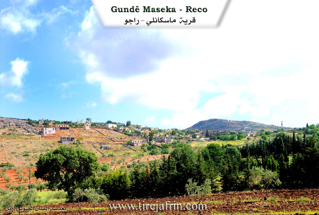
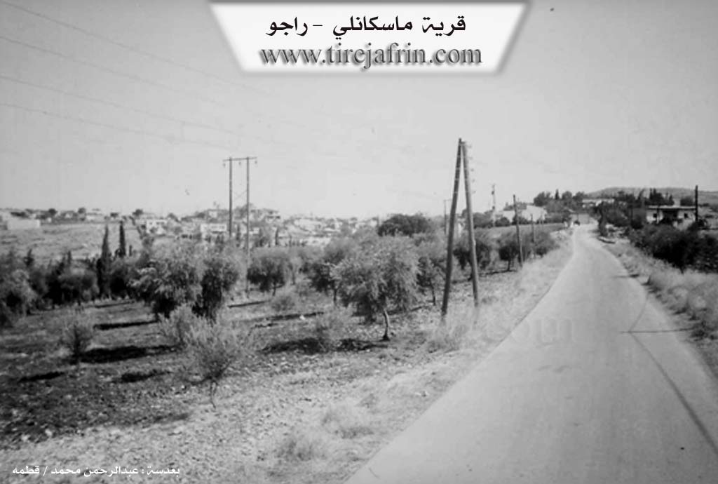
It is a medium sized village located on the southwestern slope of Bilalîko mountain, bordered to the west by the Xeta Trêna Heleb-Meydan Ekbez (Heleb-Meydan Ekbez railway line). It is stated in the book عفرين .... نهرها وروابيها الخضراء Efrîn... Her River and Her Green Hills: Masekanlî: A village in Çiyayê Kurmênc following the Reco district, Efrîn region, Heleb governorate. It is a large village located on the southeastern slope of a limestone plateau covered with oak forests, and it overlooks agricultural land with red soil to the east and south. It is 2 km away from the town of Reco towards the northwest.
It is bordered to the north by a mountain range planted with oak trees, several watercourses, the archaeological bridge (Heşrek), and the village of Ferferîk. To the south, it is bordered by a fertile agricultural plain and the town of Reco directly. To the east, it is bordered by a valley, a mountain range, the village cemetery, and the village of Mamalî. To the west, it is bordered by a high and rugged mountain range, the Riya Reco-Meydan Ekbez (Reco-Meydan Ekbez road), the Xeta Trêna Reco-Meydan Ekbez (Reco-Meydan Ekbez railway line) heading from Reco to Meydan Ekbez, the first train tunnel, the very high Ekaş mountain, the village of Surk, and Xerab Mecîd.
The number of its houses reaches about 100 houses, and the age of the village, according to the account of one of the elderly residents of the village, is about 500 years, making it one of the old villages in the region. Its old dwellings are made of stone and mud with flat wooden roofs, while the modern concrete ones have spread in its north on the adjacent slopes and in its south. A electricity network is available there, and the village drinks from a water network connected to the Reco water network. There is a telephone, a mosque, and the road between it and the town of Reco is paved, in addition to several streets in the village. It belongs to the Reco municipality.
The residents work in rain fed agriculture (olives, vines) on an area amounting to 166 hectares, and they raise sheep and goats. The village of Masekanlî is considered one of the beautiful villages due to its location and its view over the town of Reco and Ekaş mountain, which is surrounded on all sides by oak trees and forests.
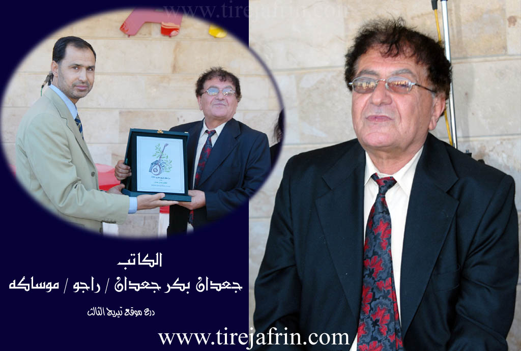
Among the most important families of the village are (Mûsa, Qabe, Qere, Cabro) and many holders of university degrees. Among the well known cultural figures in the village and at the level of Syria are the writer Cadan Cadan and the artist and buzuq player Mihemed Belko.
Village Mukhtar: Mistefa Yûsif Hesen
Sources of Information:
- Book: جبل الكرد (عفرين) دراسة جغرافية Çiyayê Kurmênc (Efrîn): A Geographical Study by د. محمد عبدو علي Dr. Mihemed Ebdo Elî.
- Book: عفرين .... نهرها وروابيها الخضراء Efrîn... Her River and Her Green Hills by عبدالرحمن محمد Ebdulrehman Mihemed from the village of Qetme.
- Studies of Navenda Tirej Soft / Ebdulrehman Hacî Osman.
- Some residents of the villages.
Preparation and execution: Manager of Tirej Efrîn site: Ebdulrehman Hacî Osman 20/12/2013
II. Summary of Maseka from Ax û Welat
Source: https://www.youtube.com/watch?v=nlhvXgPoZj8
The village of Maseka is located in the Recû district of the Efrîn region. According to local oral history, the village was established approximately 400 years ago. An elder, Apê Mihemed, recounts that the original inhabitants came from Gewrkan and established their families here. However, the history of the settlement was interrupted roughly 300 years ago when a sickness described as "wêran" caused the population to abandon the site. Eventually, the residents returned to rebuild. Today, the village is home to over 300 families, including lineages such as Mala Ecko şeqe pî, Mala Misî Yûsiv, Mala Mistik Xedê, Mala Elî Qere, Mala Kenîn, Mala Durdu, Mala Bildirêjê, Mala Hecî Şikeftka, Mala Şêxê Bilkê, Mala Hevidî, and Mala Bekir Cadan. While many residents migrated to cities like Reqqa, Heleb, and Şam for work, many returned to their land following the onset of the conflict in Sûriyê to cultivate crops like olives, melons, and grain.
Maseka is distinguished by several unique landmarks and local beliefs. Residents speak of a large stone with a hole in it known as Kevirê Kuxikê (Stone of the Whooping Cough). Historically, before modern medicine was accessible, villagers believed that passing a sick child through the hole in this stone three times at dawn, without looking back, would cure whooping cough. Adjacent to this stone stands an oak tree called Dara Mirazan (Tree of Wishes), where people tie fabrics to the branches in hopes of having their wishes granted.
Between Maseka and the neighboring village of Mamola lies a historic well known as Bîra Barcûq. The resident Jwara explains that the name may derive from "Pareçûq," while others interpret it as "the well that lifts heavy loads." This area serves as a shared space for both villages, featuring a communal cemetery. Local lore suggests this site was once a city named Barcûq containing mosques and water reservoirs, with roots potentially stretching back to the Mîtanî era. For generations, this well was the primary water source for domestic use and livestock, though it has recently been replaced by private cisterns.
The village is also defined by the Riya Hesin (Railway) constructed during the Osmanî period, around 1912, by Elman (German) engineers. The construction involved digging a tunnel through the rocky terrain, a labor-intensive process that employed local villagers from Maseka and Dewdûrê, such as Hisênê Ekeş, Reşîdê Ehme, and Hesenê Hecî Evdê. An elder, Ehmed, recounts a story passed down from his ancestors: the Elman engineer in charge was so concerned about the tunnel excavation meeting perfectly from both sides that he vowed to shoot himself with a Mauser ("Mozer a şûna xwe bikule") if the alignment was incorrect. The tunnel was successfully completed, becoming a vital link between Ewropa and the Levant.
II. Summary of Maseka from Ax û Welat 2
Source: https://www.youtube.com/watch?v=ZzLlgtowmgk
The village of Maseka is located in the Reco district of the Efrîn region and holds a history spanning approximately three to four centuries. According to village elders like Apê Mihemed, the current settlement is not the original site. The ancestors of the current residents originally lived about 300 meters away in a location now referred to as the ruins. A severe disease known locally as Kulor or Wêranşar struck that original settlement about 300 years ago. This tragedy forced the survivors to relocate and establish Maseka at its present location. The founding lineage is identified as the Xadînan family who migrated from Gawirîn and laid the foundations of the new village.
The social structure of Maseka is defined by close kinship and cooperation among several distinct families. Elders list these key lineages as Ekaşî Qapê, Mîso Yisiv, Mistê Xedê, Elî Qere, Kenîn, Dirdê, Bildirêjê, Hecî Şiketko, Şêxî Bilkê, Hewîdî, and Bekir Ce'don. These families are described as living in brotherhood and maintaining their livelihood primarily through agriculture. The village is particularly renowned for its figs (Hejîr) which are processed by the women into bastîq (fruit leather), mîj (stuffed dried figs), and leçer (jam) during the summer months to be sold in markets like Reco and Efrîn.
Spirituality and folk medicine in Maseka are centered around specific natural landmarks. The most prominent is Kevirê Kuxikê which translates to the Stone of the Whooping Cough. In the past villagers believed this large stone with a hole in it possessed healing powers. Parents would pass sick children through the hole three times and leave without looking back to cure respiratory illnesses. Next to this stone stands Dara Mirazan or the Tree of Wishes where locals tie fabrics to the branches while making vows or requests for divine favor.
Another historically significant site is Bîra Barcuq a deep well shared between Maseka and the neighboring village of Mamala. The well is situated in an area containing ancient ruins and a cemetery that locals believe dates back to the Mîtaniyan era. The name Barcuq is locally interpreted by some elders to mean "much money" in reference to a Turkish etymology while others interpret it as "burden of the people." This well was once the center of daily life where women washed clothes and shepherds watered their flocks.
The village also features a prominent section of the railway known as Rêya hesin which connects the region to Heleb and Ewropa. Built between 1912 and 1919 this infrastructure project involved German engineers. A local legend recounts how a German engineer bet that he would divorce his wife if he failed to break a particularly stubborn black rock known as Zinarê reş. He eventually succeeded using dynamite and the railway remains a testament to that era of heavy labor. Noted figures from the village include the musician Mihemed Bilko who composes songs about the pain of exile and the beauty of the village.
Transcriptions and Subtitles
| Source | Video | Subtitles | Transcript |
|---|---|---|---|
| Ax û Welat 1 | Watch Video | Download SRT | View Transcript |
| Ax û Welat 2 | Watch Video | Download SRT | View Transcript |
Foundation/Origin Information of Maseka
Among its most important families are Musa, Qaba, Qere, and Jabiru.
Source: TirejAfrin Site
The village was not always in its current location; it was originally situated about 300 meters away in a place now remembered as "Xirabê Malê" The Ruins of the House. This original settlement was abandoned after a devastating cholera outbreak forced the inhabitants to flee and re-establish their community at the present site.
Source: Ax û Walat Transcript
Inhabitants relocated from a nearby site known as the ruins of Melwer due to a cholera outbreak. The new village was founded by eleven families: Qaşî Qepê, Mûsê Îsê, Mistê Xedê, Elî Qera, Kenîn, Dordo, Evdî, Şêxê Bilkê, Bekir Cado, and Hecî Şiketko.
Source: Ax û Walat Transcript
The village's foundational identity was uniquely centered on the traditional livelihood of partridge and falcon trapping, a practice known as komirlatî.
Source: Afrin 366 Transcript
No specific origin story, but former residents identify the houses of families such as Xelîl, Xelîlê Dawid, Mihemedê Nazmî, Xoşnav, Fewzî, Sebrî, Xelîlê Beşîr, and Hesenê Hesen.
Source: Afrin 366 Transcript
Possible Village Name Meaning of Maseka
Maseka is the name of a Kurdish tribe found in Botan. Sharafkhan mentions it as "Mask".
Source: TirejAfrin Site
The high, rocky hill known as "Kevirê Kar" The Deaf Stone, was so-called by elders because its height muffled the sounds from the village below.
Source: Afrin 366 Transcript