General Information
Nahiya (Subdistrict)
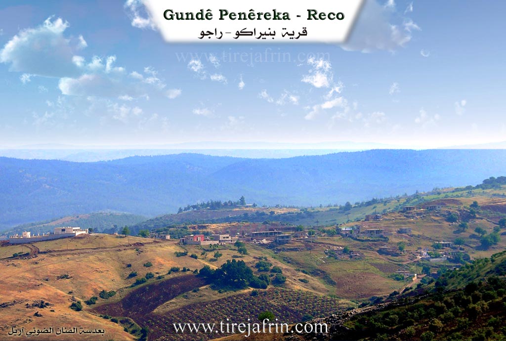
Reco
Also Known As
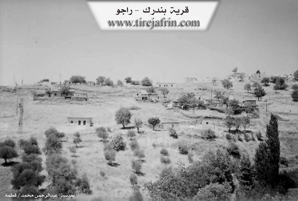
Bandrak, Penêreka, Penêrok, Pênerekê, بندرك, بنيرك, بندرليك
Tribes
Şêxî, Şêxîn
Families, Clans, etc.
Hecike, Kacike, Keçikê, Malbata Gunde, Malbata Zêro, Malbata Zîbarî, Malyê Sîntûrê, Malî 'Eçkê, Malî Simû, Simo, Sîno, Sîntûrê, Zibêr, Zêrûkê

Photos
Basic Information about Penêreka
Source: Ax û Welat
Etymology: Derived from 'penîr' (cheese); the village was historically known for its abundance of sheep and cattle, and the production of cheese and curd.
Foundation Date/Period: 1962; ancient origins at previous locations.
Springs: Kaniya Panerekê, Kaniya Hecî, Kaniya Gulê Krîsê, Kaniya Mîso, Kaniya Şeqaqa, Kaniya Qisqirane, Kaniya Tirşûkê, Kaniya Kawa, Kaniya Qûlê Xerca, Kaniya Mirad Gijî, Kaniya Şînê, Kaniya Rê, Kaniya Xelecê
Hills: Çiyayê Sîfel, Kûsa
Shrines: Ziyaretgeha Ebdulrehman, Tirba Angokuka
Ruins: Xerabê Demircî, Kavilmaya, Devera Sûrê
Trees: Ûrmanî Çêqilme
Other Landmarks: Deşta Dûlê, Geliyê Hecî, Geliye Navendê, Geliye Mêşêre, Geliyê Kîlîsê, Dêl Osman, Qazîqlî
Summaries
I. Summary from TirejAfrin Site (English) of Penêreka
Source: https://www.tirejafrin.com/site/kura%20afrin%20%20%20Reco%20-%20Penereka.htm
It is stated in the book جبل الكرد (عفرين) دراسة جغرافية Çiyayê Kurmênc (Efrîn): A Geographical Study: Penreka, Bendirk / 755 inhabitants, 23 km, 560 m /:
Penrok: Name of a plant, just as Penr means cheese in Kurdish. There is no connection between the Arabized name and its old popular name.
It is a small village located on the northern slopes of Mount Bi'v, 2 km south of the Turkish border. Some residents work in trade whenever border conditions allow for crossing without official procedures.
It is stated in the book عفرين .... نهرها وروابيها الخضراء Efrîn... Her River and Her Green Hills: Bendirk: A village in Çiyayê Kurmênc following the Reco subdistrict, Efrîn region, Heleb governorate. It is a small village located in the northern part of the mentioned mountain on the northwestern slope of the highland (Be'îfe), from which watercourses descend towards the north and west towards the valley of Çemê Reş. Its soil is colluvial. It is located 500 m south of the current Turkish border and 23 km northeast of the town of Reco.
It is bordered on the north by a valley and the Turkish border immediately; on the south by a deep valley and the village of Kusyanlî; on the east by a high, rugged mountain chain planted with forest trees and oaks called the Almond Mountain (Be'îfe) and the village of Şenkilî; and on the west by a valley and a wide plain belonging to the plains of Meydan Ekbez.
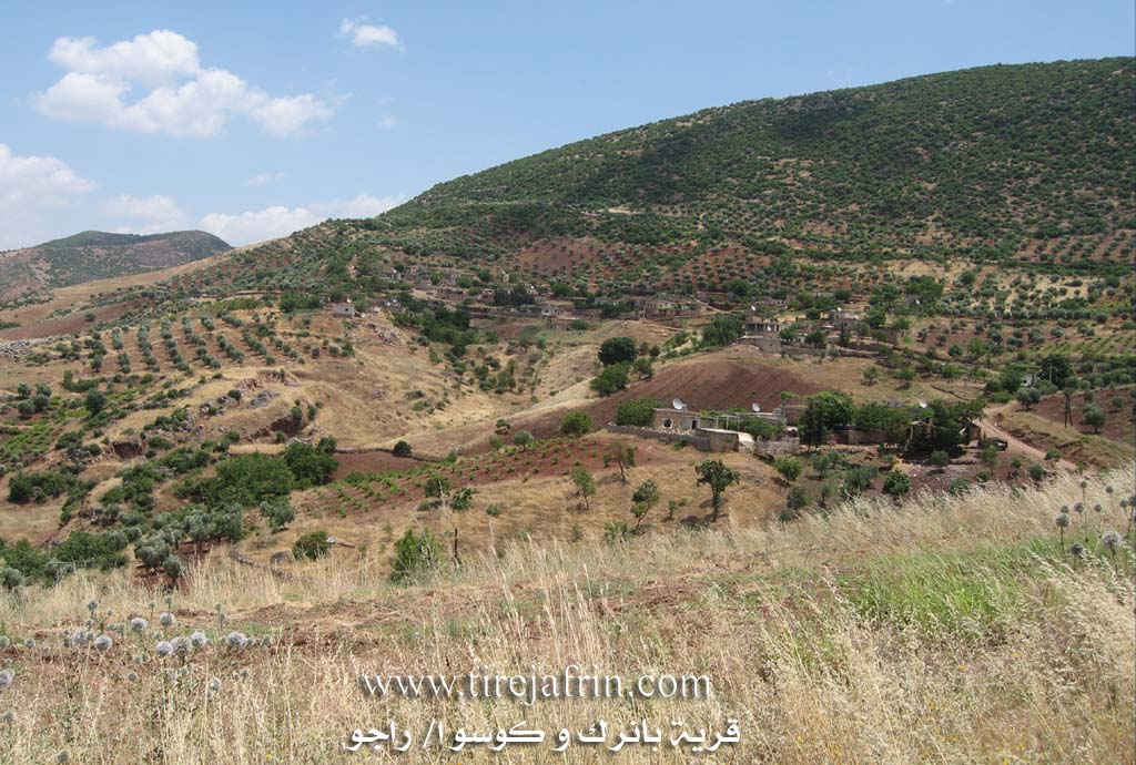
The number of its houses is about 20 houses and its age is about 350 years according to the account of one of the elderly residents of the village. Its old houses are made of stone and mud with wooden roofs, while the modern ones are cement and have expanded westward.
A primary school, a telephone network, and a rugged mountain road are available in the village. The residents work in rain fed agriculture (olives, vines, almonds) on a narrow patch of 35 hectares, and in raising sheep, goats, and cows. The village drinks from cisterns where rainwater collects or from springs found west of the village. It is one of the very poor villages due to the nature of its rugged mountainous lands which are unsuitable for agriculture. This village is one of the seven Meydan villages.
Sources of Information:
- Book: جبل الكرد (عفرين) دراسة جغرافية Çiyayê Kurmênc (Efrîn): A Geographical Study by د. محمد عبدو علي Dr. Mihemed Ebdo Elî.
- Book: عفرين .... نهرها وروابيها الخضراء Efrîn... Her River and Her Green Hills by عبدالرحمن محمد Ebdulrehman Mihemed from the village of Qetme.
- Studies of Navenda Tirej Soft / Ebdulrehman Hacî Osman.
- Some residents of the villages.
Preparation and execution: Manager of Tirej Efrîn site: Ebdulrehman Hacî Osman 20/12/2013
II. Summary of Penêreka from Ax û Welat
Source: https://www.youtube.com/watch?v=cj48n0_IksY
The village of Panerekê, located in the Reco district of the Afrin region, is a settlement with deep historical roots intimately tied to its geography and agricultural practices. The name Panerekê is derived from the word penîr (cheese), reflecting the village's historical reputation for owning large flocks of sheep and cattle and producing significant quantities of cheese and curd. According to local elders, the village was not always located at its current site. It was originally situated at Deşta Dûlê, between Şingêlê and Meydanê. Over time, the inhabitants migrated to an area known as Ûrmanî Çêqilme or Xerabê Demircî before finally settling at the current location to be closer to water sources. The current village site is approximately half a century old, with the main fountain constructed in 1962 by Şêx Şewaq.
The social structure of Panerekê is homogeneous regarding tribal affiliation, with all residents belonging to the Şêxî tribe. The village is composed of several distinct families, including Malî 'Eçkê, Malbata Zêro, Malyê Sîntûrê, Malbata Zîbarî (also referred to as Malî Simû), Malbata Gunde, and Keçikê. The village has close historical ties to Meydan Ekbez; notably, the founder of Meydan Ekbez originated from Panerekê. Due to its location near the northern border, the community has been physically divided by modern geopolitical boundaries. Many villagers have relatives in the village of Dêl Osman and Qazîqlî on the other side of the border, maintaining emotional ties despite the physical separation caused by the "têlên risayî" (barbed wire).
Panerekê is renowned for its abundance of water sources, boasting nine specific springs in its vicinity, including Kaniya Hecî, Kaniya Kawa, Kaniya Şeqaqa, and the central Kaniya Panerekê. The landscape is characterized by valleys such as Geliyê Hecî and Geliyê Kîlîsê, and overlooked by Çiyayê Sîfel. Religious and historical life centers around sacred sites like Ziyaretgeha Ebdulrehman and Tirba Angokuka, the latter serving as a shared spiritual site for Panerekê and neighboring villages like Şingêlê. Additionally, the area known as Devera Sûrê contains ancient tombs and caves, testifying to the region's antiquity.
The village preserves traditional craftsmanship and culinary arts. Residents like Mihemed Nûrî, a long-time carpenter and son of Dawûd, continue to make traditional tools. Women of the village, such as Lemia, maintain the cheese-making legacy that gave the village its name, preparing panêr, lorik, and mastê girtî for winter storage. The community also honors the memory of local martyrs who died in the national struggle, including Munzur, Berçem, and Şervan.
II. Summary of Penêreka from Ax û Welat 2
Source: https://www.youtube.com/watch?v=cKh8OrMXqq0
The village of Penêreka, situated in the Reco district of the Efrîn region, is a historic settlement defined by its abundant water sources and pastoral heritage. The name Penêreka itself is derived from the word for cheese (penêr); historically, the villagers owned large flocks of sheep and goats, producing such vast quantities of milk and cheese that the village became renowned for it. According to local oral history recounted by elders like Hamza Yûsif Murad, the village has moved locations three times. Originally, the community was located at Deşta Dûlê, between Şingêlê and Meydan. Seeking better resources, they moved to Urmanê Çeqelme (also known as Benê Te'tû), before finally settling at the current location near a reliable spring. While elders claim a history spanning a thousand years, other accounts date the current village structure to over 300 years old.
The social fabric of Penêreka is woven primarily from the Şêxîn tribe. Key families residing in the village include the Hecike, Zêrûkê, Sîntûrê, Simo, and Zibêr families. The village is located directly on the border, merely 300 meters from the line separating the region from the north. This geopolitical division severed Penêreka from its neighbors, such as the village of Dêlûsman and Qazixlî on the other side, separating families and cutting off access to agricultural lands like those held by the Sîno family. Over time, migration has reduced the population, with many families moving to Meydan Ekbez, Heleb, and Şam.
Penêreka is geographically distinguished by its valleys and numerous springs. The villagers identify at least nine distinct springs in and around the settlement, including Kaniya Kawa, Kaniya Hecî, Kaniya Silêv, Kaniya Mîso, and Kaniya Şaqaqê. A notable historical development occurred in 1962 when Şêx Çewaq, a local religious leader, constructed a protected basin and fountain system for the main village spring to ensure clean water for drinking and religious ablutions.
The landscape is dotted with significant sites, including the ruins of Xerabê Demirci and Koza, and the ancient area of Devera Sorî, which contains caves and old graves. Spiritual life is centered around local shrines such as Ziyaretgeha Ebdilrehman to the west and Sultan Laba to the east, where villagers traditionally pray for rain. The village is also home to Tirba Ango Koka, described as the village mosque. In contemporary times, the village honors the memory of local martyrs such as Munzur, Berçem, Şervan, and Yûsif, who died in regional conflicts. Culturally, the village preserves traditions of woodcraft, exemplified by the carpenter Mihemed Nûrî, and the communal preparation of winter foods like lêrî and preserved cheese.
II. Ax û Walat Book 1
VILLAGE OF PENÊREKA
28.6.2016
The village of Penêreka is affiliated with the Reco district of the Efrîn canton, about 30 km northeast of the city of Reco, 60 km north of the city of Efrîn, and 4 km east of the town of Meydan Ekbezê.
Previously, the village was affiliated with the Bilbilê district.
Because the people of the village used to own sheep and the village was famous for making cheese, it was named Penêreka.
Previously, the village was in a place called (Xirabê Demircî), then the people of the village came and settled around the spring, which is the current location of the village.
The village of Penêreka is very ancient, and its age is over 900 years. It is a border village and is about 300 m from the northern border. Therefore, Turkish soldiers often attempt to intervene in Rojava, and because of these actions, farmers cannot safely go to their orchards and fields.
There are 4 families in the village:
The family of Zêrûk, ’Eckê, Sîntore, and the family of Zîbarî, many of whom have settled in the village of Me’mila. All families are from the Şêxî tribe.
The village of Penêreka was built in the Penêreka valley around the spring whose both sides are mountains.
Opposite the village and in Mount Behîvê, there is a large rock named (Benê Teto); it looks like a rock that has been cut.
To the east of the village is the Tomb of (Kuka), which is like the cemetery for the villages of Penêreka and Dêl Osmanê on the border and the village of Şingêlê. To the south is the village of Kosa, to the west Meydan Ekbez, and to the north is the northern border and the village of Qoca, which has remained in ruins and has become a minefield.
The area of (Sûrê) is like an ancient cemetery; ancient graves along with a number of caves are found there. They are witnesses to the ancient history of this area.
To the west of the village is Mount (Sîfel); there used to be a defense outpost of the Syrian army there.
The valley of (Hecî) to the east of the village joins with the Mêşê valley over the village spring to become one valley.
The village of Penêreka is famous for its abundance of springs, such as the spring of Geliyê Hecî, the Şînê spring, the Rê spring, the Qisqiranê spring, the Kawa spring, the Şeqaqê spring, the Tirsokê spring, the Mîso spring, the Xelecê spring, and the Penêreka spring, along with them is also the Gola Kilîsê.
It is worth noting that all the fields around the village are mountainous, but their soil is red, which is very suitable for agriculture; they are planted with olives and vineyards.
The shrine of (Ebdilrehman) is to the west of the village, and that of (Sultan) is to the northwest. The villagers visit these shrines to pray for rain.
About 10 families have settled in the Syrian capital, Damascus.
There are about 60 houses and around 800 people from the village of Penêreka. It is worth mentioning that the founders of the town of Meydan Ekbezê are from this village, so there are about 100 houses of people from Penêreka there.
The people of the village of Penêreka make their living mostly from agriculture, and the care of olive trees and vineyards is paramount, and along with them, there are walnut, pomegranate, almond, and apricot trees, and also vegetable gardens with tomatoes, cucumbers, and peppers, along with grains like wheat, barley, lentils, and chickpeas.
Besides agriculture, some families own sheep and make a living from their products. Some people also own honey bees.
Several young people from the village go to Reco and Meydan Ekbezê daily and work in various factories.
About 6 people also work in the institutions and bodies of the Autonomous Administration in Reco and Efrîn.
There are 6 martyrs from the village who lost their lives in the National Liberation War:
Ş. Muzir, Berçem, Şervan Çiya, Welîd, Cemal, and Ş. Yûnis.
Like all border villages, Penêreka also has relatives on the other side of the border, especially in the village of Qaziqlî, and the official wires that have divided our country have not been able to separate the people on both sides of the border. Therefore, to this day, the relations of the people of the village with their relatives and friends on the other side continue.
Transcriptions and Subtitles
| Source | Video | Subtitles | Transcript |
|---|---|---|---|
| Ax û Welat 1 | Watch Video | Download SRT | View Transcript |
| Ax û Welat 2 | Watch Video | Download SRT | View Transcript |
Foundation/Origin Information of Penêreka
This village is one of the seven Medaniyat Villages.
Source: TirejAfrin Site
Its founding inhabitants were shepherds who settled at a sheepfold known as Ûrmonê Çêqilma in the Dûlê Plain. The village relocated three times before settling in its current location on a hill called Banê T'etû. The main village spring is approximately 600 years old and was developed into its current form in 1962 by an elder named Sheikh Shawaq.
Source: Ax û Walat Transcript
The village traces its origins to the Dûlê plain before its inhabitants, primarily shepherds from clans like the Rodbînî, relocated. It was founded by four main families—Mala Ecîkê, Mala Zêro Kê, Mala Danbermê, and Mala Sîntorê/Simo yê Zibêr.
Source: Ax û Walat Transcript
Possible Village Name Meaning of Penêreka
Penêrok is a plant name, as Penêr means cheese in Kurdish.
Source: TirejAfrin Site
Its name is derived from the Kurdish word for cheese, 'penêr,' as its founding inhabitants were shepherds who began making cheese to preserve their surplus milk.
Source: Ax û Walat Transcript
The village's name is derived from its deep-rooted tradition of cheese making ('penîr çêkirin').
Source: Ax û Walat Transcript