General Information
Nahiya (Subdistrict)
Mabeta
Also Known As
Al-Yatimah, Sewiyê, Sêwiya, Sêwiyê, Uksuzli, اليتيمة, اوكسوزلي, سيويا
Tribes
Milan
Families, Clans, etc.
Emko, Emîko, Emîkî, Hec Umer, Mala 'Imikê, Mala Nasirler

Photos
Basic Information about Sêwiya
Source: Ax û Welat
Etymology: Derived from the word sêwî meaning orphan, named after a child born to the sole surviving pregnant woman following an Ottoman massacre of the original inhabitants
Springs: Kitix
Hills: Çiyayê Çancê
Shrines: Mezara Hecî Yûsif
Ruins: Me'sera avdî
Wells: Bîra Kêrbeze
Summaries
I. Summary from TirejAfrin Site (English) of Sêwiya
Source: https://www.tirejafrin.com/site/kura%20afrin%20%20%20mebetli%20-%20oksazle.htm
According to the book جبل الكرد (عفرين) دراسة جغرافية Çiyayê Kurmênc (Efrîn): A Geographical Study by د. محمد عبدو علي Dr. Mihemed Ebdo Elî: Sêwiya, Oksuzlî, Al Yatima /798 inhabitants - 390 hectares - 12 km - 700 m/:
Sêwiya: The folk name means "the orphan" (sêwî). There is an old and well known story regarding this orphan who gave his name to the village, related to the Emîkî family, the ancient inhabitants of the village. As for the Ottoman name Oksuzlî, and the Arabized Al Yatima, they are translations of the original Kurdish name.
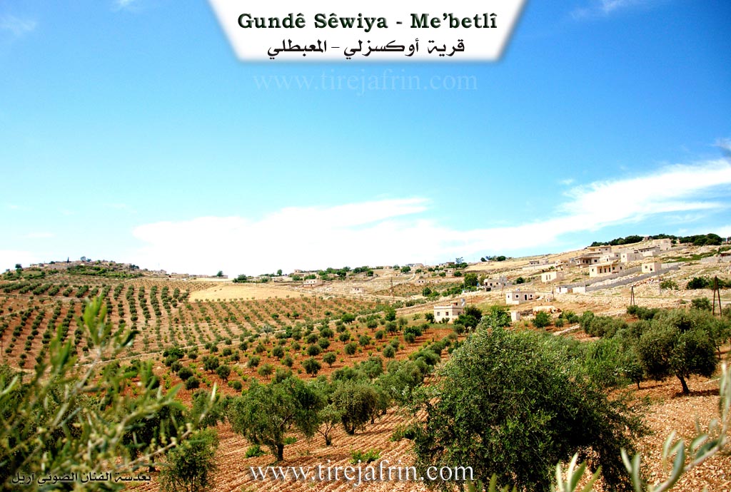
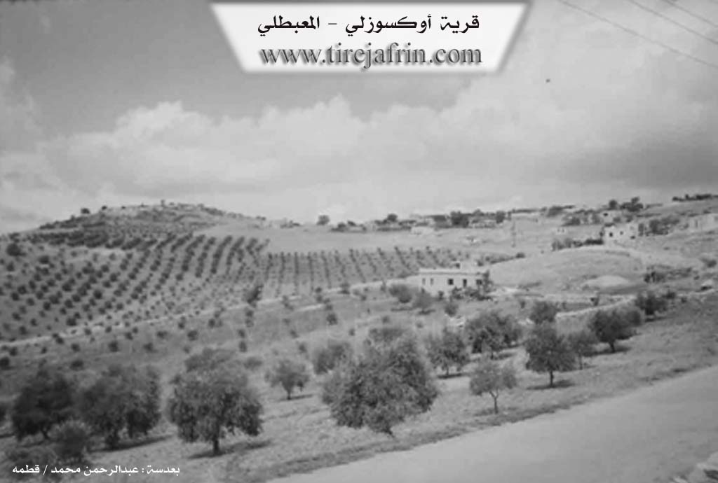
It is a small village located atop a high mountain peak, giving it a beautiful and fortified natural view from afar. There is a shrine (mazar) on its eastern side, and next to it are graves dated to 180 years ago.
According to the book عفرين .... نهرها وروابيها الخضراء Efrîn... Her River and Her Green Hills by the writer عبدالرحمن محمد Ebdulrehman Mihemed from the village of Qetme:
Oksuzlî is a village in Çiyayê Kurmênc, affiliated with the Mabeta township, Efrîn region, Heleb governorate. It is a small village located in the middle section of the mentioned mountain, atop a rocky tongue that forms the western end of Çiyayê Hawar. It overlooks to the west a depositional plain through which the Xeta Trêna Heleb-Meydan Ekbez (Heleb-Meydan Ekbez railway) extends. It is located to the north of the town of Mabeta at a distance of 12 km. Its soil is clay like.
It is bordered to the north by a harsh, steep slope and the village of Berbendê; to the south by a steep slope planted with olive trees and the village of Gulîbo; to the west by a steep slope, Geliyê Tîra, the Xeta Trêna Meydan Ekbez (Meydan Ekbez railway line), and the village of Hemşilê; and to the east by a slope planted with olive trees and the village of Heyatê. A deep valley passes through the center of the village, separating the village into two parts: the elevated part in the northwest and the lower part in the south.
The number of its houses amounts to about 45 houses, and its age is about 500 years. Its old houses are made of stone and mud with flat wooden roofs, while the modern ones are cement and spread towards the east. An electricity network is available, as well as a water network connected to a well south of the village of Gulîbo. It has a primary school and a paved road up to the center of the village and neighboring villages.
The residents work in rainfed agriculture on an area of 270 hectares (grains, legumes, olive trees, and vines), and they practice irrigated farming from well water on an area of 20 hectares for summer vegetables, alongside raising sheep and goats. Among its most important families is the Emîkî or Emko family (they are the first to inhabit the village since ancient times). There is a modern olive press in the village.
Village Mukhtar: Ehmed Zemcî Heyder
Preparation and Execution:
Director of the Tirej Efrîn website: Ebdulrehman Hacî Osman
20/12/2013
Sources:
- Book: جبل الكرد (عفرين) دراسة جغرافية Çiyayê Kurmênc (Efrîn): A Geographical Study by د. محمد عبدو علي Dr. Mihemed Ebdo Elî.
- Book: عفرين .... نهرها وروابيها الخضراء Efrîn... Her River and Her Green Hills by عبدالرحمن محمد Ebdulrehman Mihemed from the village of Qetme.
II. Summary of Sêwiya from Khalil Sino
Source: https://www.youtube.com/watch?v=47WqRl-RfiQ
The village of Sewiya, also referred to as Sêvya, is located in the Afrin region and is distinguished by its high altitude and commanding views over the surrounding landscape. According to local elders, including Xalê Cemîl, the village has a deep history spanning approximately one thousand years. It is considered older than the neighboring village of Ba'dîna. The origins of Sewiya are traced back to a migration from Deştê Kedaşk. Xalê Cemîl recounts that the first settler was a solitary figure described as Sewî (an orphan), and the village's name is believed to stem from this founding individual. Following this initial settlement, the Mala 'Imikê family arrived, establishing themselves as one of the oldest lineages in the area.
Historically, life in Sewiya was defined by its geography. Due to its elevation, the village lacked immediate access to water sources. Elders recall a time when residents had to travel to Ba'dîna on foot or with animals like donkeys (ker) and mules (qatir) to fetch water in tins. This daily struggle is a significant part of the village's collective memory, though modern times have brought cisterns and water tanks. The village historically shared a close connection with Ba'dîna, though Sewiya maintains a distinct identity. Culturally, the village is known for the preparation of Kîto, a traditional dish made with cracked wheat and meat, which was historically prepared in large quantities and distributed among ten to fifteen households during religious observances like Ashura.
The spiritual center of the village is Ziyareta Hac Yûsif, a sacred shrine located within the village boundaries. Kekê Reşîd, the shrine's custodian, estimates the site to be around a thousand years old, mirroring the age of the village itself. The shrine complex features an ocaq (hearth) and ancient trees. It serves as the primary burial ground not only for the roughly sixty households currently residing in Sewiya but also for the diaspora; families bring deceased relatives from as far as Heleb (Aleppo) and Elmanya (Germany) to be interred there. The site is revered, and locals visit it to make vows, offer sacrifices (qurban), or simply rest in its cool, wooded shade during the summer.
Socially, the village structure includes ancient families such as Mala 'Imikê and Mala Nasirler. While the population has been impacted by emigration to Europe (Ewrûpa), the community remains tight-knit, with significant financial support sent back by the younger generation to assist their elders. The village overlooks a vast panorama, with residents able to spot numerous other settlements from their vantage point, including Goliya jûr, Berbenê, Gundê Xofê, Gundê Dêrwiş, Gundê Hisên, Qurqo, Gundê Xelîl, and Me'melo.
II. Summary of Sêwiya from Ax û Welat
Source: https://www.youtube.com/watch?v=DlyQNeDLXZY
The village of Sêwiya is situated in the Mabeta district of the Efrîn region, perched high on the slopes of Çiyayê Çancê. Its name carries a tragic origin story rooted in the eighteenth century. According to local elders like Mihemed, the village was named Sêwiya, meaning the place of orphans, following a brutal Ottoman massacre. The oral history recounts that Ottoman forces killed the entire population of the previous settlement, sparing only one pregnant woman. The child she bore grew up as an orphan, or sêwî, and the village was eventually reestablished around this surviving lineage.
The history of Sêwiya is deeply intertwined with the resistance of the Milan tribe. Historically, the inhabitants of this region were Êzdî Kurds who faced persecution and forced conversion to Islam around the 1700s. A pivotal moment recorded in the village history occurred in 1775 when the local leader Omer Agha, also known as Emîko, refused to pay taxes to the Ottoman state. This defiance led to a major conflict where many locals were killed or exiled to Konya and Hêman. The village elders recount that the Milan tribe in this area, stretching from Şiyê to Şitka, historically fell under the influence of leaders like Oqca Izzeddîn and Şêx Êzdînê Êzdî.
Several notable landmarks and shrines punctuate the landscape around Sêwiya. To the east lies Bîra Kêrbeze, also known as Kêlbaze, a historic site associated with a fierce battle between Ayubbid forces and Crusaders. Here stands the shrine of Mezara Hecî Yûsif, a commander who fell in battle, which remains a site of visitation for the local people. Another local legend concerns Zîzê Xatûn, the daughter of Omer Agha, who was martyred during the conflicts with the Ottomans and is remembered in local songs. For water, the villagers historically relied on a distant spring called Kitix, located four kilometers away, and transported water by donkey before the construction of private cisterns.
Daily life in Sêwiya has traditionally revolved around agriculture and stone quarrying. The villagers are known for their skill in cutting the high quality white stone of the area, a trade passed down through generations since the time of the Armenian presence in the region. They also cultivate olives and prepare winter provisions like megdûz and nanê rûn. The community maintains distinctive cultural traditions, such as a children's game involving a mock wedding procession singing Zava gul e û bûk şitil e, and the şeqîl or kûstek ceremony, where a cord is cut between a toddler's legs to encourage them to walk.
Transcriptions and Subtitles
| Source | Video | Subtitles | Transcript |
|---|---|---|---|
| Ax û Welat 1 | Watch Video | Download SRT | View Transcript |
| Khalil Sino 1 | Watch Video | Download SRT | View Transcript |
Foundation/Origin Information of Sêwiya
The Umayko or Umako family were the first to inhabit the village since ancient times.
Source: TirejAfrin Site
Possible Village Name Meaning of Sêwiya
Sêwiya: The folk name meaning "the orphan". The Ottoman name Uksuzli, and the Arabized al-Yatimah, are both translations of the original Kurdish name.
Source: TirejAfrin Site