General Information
Nahiya (Subdistrict)
Cindires
Also Known As
Tatar, Tatataranlı, Tetera, تاتار, تاتارانلي, تاتارو
Tribes
El-Neîm, Mehmediya, Reşwanî, Reşî
Families, Clans, etc.
Ebdê Heskê, Hec Hesen, Hesenê Meremê, Mehmediya, Menanê Xelê, Nûrî Cafer, Xalê Hasbî, Xelê Teter

Photos
Basic Information about Tetera
Source: Ax û Welat
Etymology: Possibly means "father old man" (bav pîr) or "My Teter," though formerly known as Xirabê Tetera
Old Names: Xirabê Tetera
Foundation Date/Period: 125 years ago
Caves: Şikefta Fîlan
Springs: Kaniya Senorê
Hills: Qaziqli, Çiyayê Hawarê, Çiyayê Seydo
Shrines: Ziyareta Qehzeqla, Şêx Mihemed
Ruins: Xirabê Tetera, Gumitê
Other Landmarks: Geliyê Corcem, Geliyê Qûserê, Geliyê Meselê
Summaries
I. Summary from TirejAfrin Site (English) of Tetera
Source: https://www.tirejafrin.com/site/kura%20afrin%20Cindires%20-tetera.htm
It is stated in the book جبل الكرد (عفرين) دراسة جغرافية Çiyayê Kurmênc (Efrîn): A Geographical Study by د. محمد عبدو علي Dr. Mihemed Ebdo Elî: Tetera, Tataranlî, Tatar /640m altitude, 8km distance/:
Tatar is a Kurdish proper name for its first inhabitant.
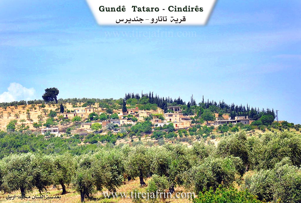
It is a small village located on one of the western peaks of Mount Heştiya, which is called Mount Qaziqlî. It is surrounded by olive fields and dense forests. Its location is a beautiful summer resort. It was a refuge for the fighter Miho Êbo Şaşo at the beginning of the third decade of the twentieth century, and he was killed there.
It is stated in the book عفرين .... نهرها وروابيها الخضراء Efrîn... Her River and Her Green Hills by the writer عبدالرحمن محمد Ebdulrehman Mihemed from the village of Qetme regarding Tataranlî:
It is a village in Çiyayê Kurmênc, administratively belonging to the Cindirês district of the Efrîn area, Heleb governorate. It is a small village located on the western and central slope of Çiyayê Kurmênc and on a mountain height that is sloping, harsh, and very steep, with calcareous alluvial soil. It is 8km away from the town of Cindirês toward the northwest.
It is bordered to the north by a rugged mountain chain, several streams planted with forest trees, and the village of Hac Hesenlî. To the south, it is bordered by a slope, a stream, several mountain heights planted with olive trees, and the village of Kefer Sefrê. To the west, there are rugged mountain heights, two streams, the village of Bazayanlî, and its ruin. To the east, there are two streams, a rugged mountain slope planted with olive and forest trees, and the villages of Çobanlî and Kûrdanlî.
The number of its houses reaches about 15 houses, and its age is about 150 years. Its old houses are made of stone and mud with flat wooden roofs, while the modern ones are concrete and spread along the sides of the public road. A modern electricity network is available, as well as a paved road passing through its center to the village of Hac Hesenlî and the town of Cindirês. The residents drink from collected rainwater and cisterns dug next to the houses, and recently some artesian wells were dug for drinking and irrigating vegetables. Its inhabitants work in rain fed agriculture (olives, vines, pomegranate, apricot) alongside raising sheep and goats. It is administratively a farm belonging to Kefer Sefrê.
Preparation and execution:
Manager of the Tirej Efrîn site: Ebdulrehman Hacî Osman
20/12/2013
Sources
Book: جبل الكرد (عفرين) دراسة جغرافية Çiyayê Kurmênc (Efrîn): A Geographical Study by د. محمد عبدو علي Dr. Mihemed Ebdo Elî.
Book: عفرين .... نهرها وروابيها الخضراء Efrîn... Her River and Her Green Hills by عبدالرحمن محمد Ebdulrehman Mihemed from the village of Qetme.
II. Summary of Tetera from Ax û Welat
Source: https://www.youtube.com/watch?v=ElgqSyvOiaI
The village of Teteran, also referred to as Tetera, is a small settlement perched approximately 700 meters above sea level on the Qaziqli mountain (also recorded as Qazilqî) within the Cindirêsê district of the Efrîn region. While the exact origin of the name is debated, with suggestions ranging from "bav pîr" (father old man) to a pre-existing name Xirabê Tetera, the modern village was founded approximately 125 years ago. The first settler, Hesenê Meremê (also referred to simply as Hesen), arrived from the neighboring village of Yelanqozê. He found shelter in caves before constructing homes and cultivating olive groves and vineyards.
The social structure of Teteran is deeply interconnected with the nearby villages of Yelanqozê and Kefersefrê. The residents primarily identify with the Mehmediya family, which expanded into a large lineage. They trace their tribal roots to the Reşî or Reşwanî confederations. Additionally, the village is home to residents of Arab origin, specifically from the El-Neîm tribe, such as the shepherd Mihemed. However, these residents have lived in the region for over a century, adopted the Kurdish language and culture, and consider themselves fully integrated into the local community.
Teteran is historically significant for its role in the resistance against the French Mandate in the early 20th century. Three brothers from the village, Birîn Hesen, Mistefa, and Xelîl, were active insurgents. The village also served as a sanctuary for the renowned rebel leader Miheyê Bşoşe, who hailed from the ruined village of Gumitê. Around 1910, Miheyê Bşoşe and his fighters used the caves around Teteran as a base for operations against French forces, supported by local figures like Mistefa Çolak and Ehmedê Rûtû.
The village is geographically defined by the Qaziqli mountain, which hosts the significant Ziyareta Qehzeqla. This shrine attracts pilgrims from across Çiyayê Kurmênc and Mabetê, particularly on Fridays and during July. The area around the shrine serves as a communal gathering space and was historically a meeting point for poets and musicians, including the legendary Cemîl Horo and Bavê Selah. Other notable landmarks in the vicinity include the Kaniya Senorê spring (the traditional water source located in Geliyê Corcem), the Şikefta Fîlan (Cave of Elephants), and the valleys of Geliyê Qûserê and Geliyê Meselê. A martyrs' cemetery is also located nearby on Çiyayê Seydo.
II. Summary of Tetera from Ax û Welat 2
Source: https://www.youtube.com/watch?v=OuFNdlzDnv0
This documentary transcript captures the experiences of displaced Kurdish residents from the Efrîn region who are currently residing in the Fûceya Tertabê camp near Qamişlo. The host speaks with numerous displaced people who share stories of repeated migrations, noting that many have been forced to move up to four times over nine years, passing through areas like Şehba, Heleb, Dêrik, Tebqa, and Reqqa before arriving at their current location.
The people interviewed hail from various agricultural and culturally rich villages across the Efrîn countryside. A woman named Helîme explains her roots lie with the Nûrî Cafer and Xalê Hasbî families. Although her parents are originally from Tirmîş and Erendê in the Şiyê district, her family later grew up in Heleb. Another interviewee named Zekiye speaks fondly of her home village of Dêrsiwanê, located near the historical ruins of Kela Hûrî. She notes that Dêrsiwanê is highly regarded for its artistic contributions, being the birthplace of revered musicians like Ednan Dilbirîn, Hesen Şêxo, and Bavê Şiyar.
Other residents describe the vibrant agricultural life of their home villages. A man from Kurzêlê in Deşta Cûmê recalls how their land was lush with pomegranate orchards, apple trees, and olive groves, and notes that the village was famous for its folk dance troupes. A woman named Fatma proudly mentions her origins in Behdîna, a village known for a traditional dish called dankê Behdîna. She explains how close knit the neighboring communities were, listing nearby places like Dêrmilyan, Qopê, and Korka, which sit across from notable geographical landmarks such as Çiyayê Hawarê and Geliyê Tîra.
The conversation highlights the deep connection the people of Efrîn have to their land and traditional ways of living. An elder named Elî recounts his memories of extensive beekeeping and farming, expressing pride in the resilience of his community. Displaced shepherds like Welîd from Raco and another man from the mountain village of Omeran talk about preserving their livelihood by keeping their flocks of sheep with them throughout their arduous journeys. Water resources like Meydankê and the Çiyayê Bêlê mountains are remembered fondly in both conversation and song.
Throughout the interviews, there is a recurring theme of profound longing. Many individuals still carry the physical keys to their original homes in their pockets. Singers like Mihemed Hamo perform passionate songs about their homeland, explicitly naming figures like Ceboyê Sîtê and places like Cindirêsê. The program concludes with a powerful sentiment shared among the displaced families: despite losing their possessions and facing extreme hardships, they remain steadfast in their hope and preparation to return to their ancestral villages in Efrîn.
II. Ax û Walat Book 2
30
TETERA
15.2.2017
[Image of the village of Tetera]
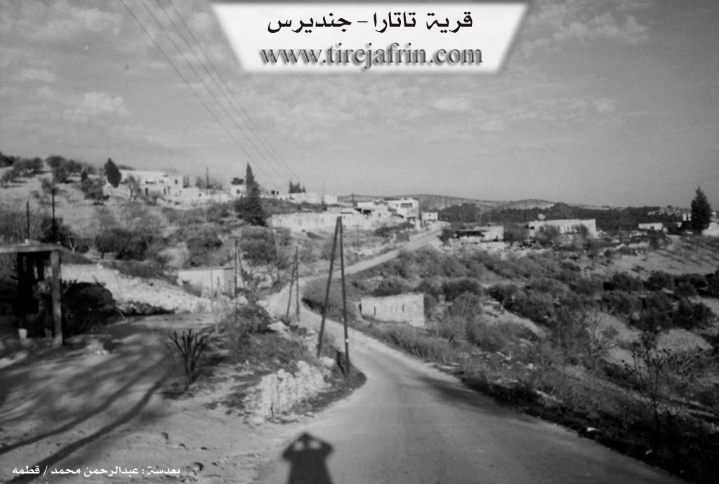
The village of Tetera is affiliated with the Cindirêsê district of the Efrîn canton, located 10 km north of the city of Cindirêsê, 30 km northwest of the city of Efrîn, and 4 km east of the Martyr Seydo Cemetery.
The village of Tetera is located on Qaziqlî mountain; the elevation of this mountain is nearly 700 m above sea level.
The village of Tetera is an ancient village with many historical sites, but the inhabitants of the village came not long ago. It is not known where the village's name came from, but long ago and before the village was populated, it was known by the name ((Ruins of Tetera)).
Hesenê Mêremê was the first person to settle in the village. He is originally from the village of Yalanqozê and is from the Reşwanî tribe.
31
Because the surroundings of the village were the property of the people of Yalanqozê village, some families from Yalanqozê village came, built houses, and established the village.
There are only 2 families in the village:
The family of Hesê Mêremê, from which most of the village's people descend, and the family of Mistefa Xelef, who are originally from the Arab Micedemî tribe, came from the Bab region and settled in the village of Tetera as sheep owners.
To the east of the village are the village of Çobana and the Qusêrî Valley, which is like a large forest adorned with terebinth and oak trees; to the south, Xirabhûrik and the village of Kora; to the west, the Martyr Seydo Cemetery of the Martyrs and Qaziqlî mountain, in which is the Qaziqlî shrine; and to the north lie the Me’serê Valley, the Fîlan Caves, and the village of Hechesna.
There are 12 houses and nearly 200 people in the village, but most of the village's population lives in the city of Cindirêsê.
The people of the village make their living from agriculture and raising livestock. Some people work as laborers in various factories in Cindirêsê. 5 people work in the institutions and agencies of the Autonomous Administration in Cindirêsê and Efrîn.
There is one martyr from the village named Martyr Aydin. The village's commune is affiliated with the commune of Yalanqozê village.
32
Birîmê Hesen, Mistefa, and Xelîl, all three brothers, as rebels against the French occupation, along with Mihê Îbşaşo, carried out many activities and battles.
It is worth mentioning that Mihê Îbşaşo, as the first rebel in the Kurmênc Mountain region against French rule, lived in the village of Tetera and carried out activities against French soldiers in the Hemamê and Cûmê regions, and he was also killed in the village of Tetera and his body was handed over to the French, therefore his grave is not known.
The Qaziqlî shrine is very ancient. The people of the canton visit it on Fridays, and especially the Alevi people, who perform their prayers and sacrifices there.
Transcriptions and Subtitles
| Source | Video | Subtitles | Transcript |
|---|---|---|---|
| Ax û Welat 1 | Watch Video | Download SRT | View Transcript |
| Ax û Welat 2 | Watch Video | Download SRT | View Transcript |
Foundation/Origin Information of Tetera
A small village located on one of the western peaks of Hashteya Mountain. It was a refuge for the fighter Maho Ibo Shasho in the early third decade of the twentieth century, and he was killed in it.
Source: TirejAfrin Site
The current residents, belonging to the Mehmûdî family of the larger Reşî tribe, settled the previously uninhabited land after migrating from the nearby village of Yalanqoz. These founding families established their community by digging wells, planting olive and grape vineyards, and raising sheep. According to local elders, a previous group of inhabitants were known as the Mawetî.
Source: Ax û Walat Transcript
Possible Village Name Meaning of Tetera
"Tatar" is a Kurdish proper name of its first inhabitant.
Source: TirejAfrin Site
The name is an old Kurdish word for "ancient" and was once known as "Xirabê Tetera" (Ruins of Tetera). According to local elders, the name was given by a previous group of inhabitants known as the Mawetî.
Source: Ax û Walat Transcript