General Information
Nahiya (Subdistrict)
Efrîn
Also Known As
Cetal Ziyaretê, Zaretê, Ziyaretê Şêx Yûsif, Çetelziyaretê, Çetel Ziyaret, Çetel Ziyarête, Şetel Ziyaretê, الزيارة, جتال زيارة, زيراتي حنان, زيراتي
Tribes
Ecêlî, Eşîra Îbrahîm Paşa, Millî, Rûbar, Rûbaran
Families, Clans, etc.
Bekrî, Ehmed, Hemîdo, Hemûto, Hesen, Kosa, Mala Misrî, Malê Beg, Malê Bekir, Malê Derwêş, Malê Elî Beg, Malê Elî Bêc, Malê Eyûb, Malê Eşê, Malê Helîq, Malê Hemadî, Malê Hemmûtê, Malê Hemo, Malê Hemê, Malê Hilo, Malê Kedro, Malê Koso, Malê Mûsê, Malê Telûbê, Malê Îbiş, Malê Îsikê, Malê Ûsakê, Oso, Welyo, Yûsif, Îbiş, Îso

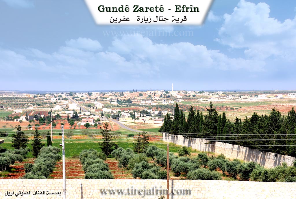
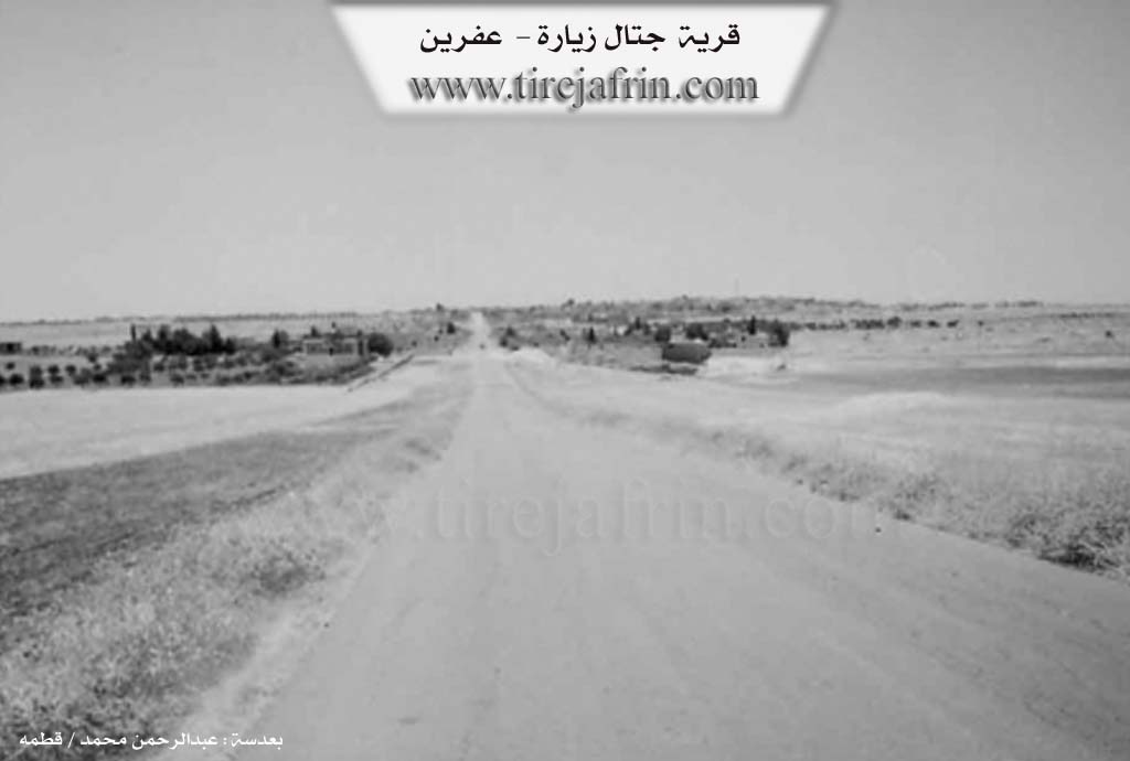
Photos
Basic Information about Zaretê
Source: Ax û Welat
Hills: Çiyayê Lêlûn, Çiyayê Kurmênc
Other Landmarks: Şehba, Nibil, Zehra
Summaries
I. Summary from TirejAfrin Site (English) of Zaretê
Source: https://www.tirejafrin.com/site/kura%20afrin%20markaz-%20Zarete.htm
It is stated in the book جبل الكرد (عفرين) دراسة جغرافية Çiyayê Kurmênc (Efrîn): A Geographical Study by د. محمد عبدو علي Dr. Mihemed Ebdo Elî: Zaret, Cetel Ziyare, Ziyare / 1906 people 370 houses 35km 481m /:
Cetel Ziyare: This is the name before Arabization. It means "Double Shrine" in Turkish, in reference to two shrines found there. One of them is known by the name Şêx Yûsif el-Kûfî, and it is located inside the village cemetery. The Kurds shortened the name and pronounced it "Zaretî".
It is a large village located on the eastern slope of Çiyayê Lêlûn. It contains a large percentage of holders of higher educational degrees and state workers. Among them is the writer and author Imad Kosa.
It is stated in the book: عفرين .... نهرها وروابيها الخضراء Efrîn... Her River and Her Green Hills by the writer عبدالرحمن محمد Ebdulrehman Mihemed from the village of Qetme:
Cetal Ziyare: A village in Çiyayê Lêlûn, following the subdistrict of the villages of the center and region of Efrîn, Heleb governorate. It is a large village located in the Çiyayê Lêlûn chain and the Ghubariya area. It is bordered to the north by a slope, a valley, an agricultural plain, and the villages of Ebîn and Basilhaya. To the south by a rugged mountain chain, the ruins of Qunêtra (Xirbet Qunêtra), El Meyasa, and the town of Nubl. To the east by a slope, a valley, the farm of Mezra Şehba, the Riya Heleb Efrîn (Heleb Efrîn road), and the village of Kefîn. To the west by a mountain chain, forests, and the village of Eqîbe.
It follows the subdistrict of the villages of the Efrîn center, Heleb. The number of its houses reaches 150 houses, and its age is 400 years. Its old houses are of stone with wooden and mud roofs, and the modern ones are of stone and cement. An electricity network, drinking water, a primary school, and a mosque are available there. It belongs to the municipality of Eqîbe. A paved road connects to the Riya Heleb (Heleb road) and passes through its center to the rest of the neighboring villages up to the village of Basûte.
Its residents work in agriculture, specifically the cultivation of grains, olives, and vines, and the raising of livestock, goats, and cows due to the nature of the mountainous region around it, which is called Çiyayê Lêlûn. Currently, modern houses have spread on both sides of the road up to the junction of Riya Heleb Efrîn Ezaz (Heleb Efrîn Ezaz road) and the villas spread along the road named Mezra Şehba, located to the east of the village with the gas station.
Among the families present in the village are: Kosa, Îbiş, Ehmed Îso, Hesen Hemûto, Welyo, Yûsif, Hemîdo, Bekrî, and Oso. Among the cultural and scientific figures are the writer Imad Kosa and Dr. Feysel Ehmed (PhD in Economics from the University of Heleb) and many holders of university degrees.
The village mukhtar is Zekeriya Cumhe el Hesen, who is one of the prominent social faces in the village and has a status among the people of the village.
Preparation and execution:
Manager of the Tirej Efrîn site: Ebdulrehman Hacî Osman
20/12/2013
Sources
Book: جبل الكرد (عفرين) دراسة جغرافية Çiyayê Kurmênc (Efrîn): A Geographical Study by د. محمد عبدو علي Dr. Mihemed Ebdo Elî.
Book: عفرين .... نهرها وروابيها الخضراء Efrîn... Her River and Her Green Hills by عبدالرحمن محمد Ebdulrehman Mihemed from the village of Qetme.
II. Summary of Zaretê from Ax û Welat
Source: https://www.youtube.com/watch?v=Q8DDthV_mtw
The village of Çetel Ziyaret (also referred to simply as Ziyaret) is located in the Şêrawa district of the Efrîn region. Geographically strategic, it is situated on the border between Efrîn and Şehba, approximately 30 kilometers from the center of Efrîn and 30 kilometers from Heleb (Aleppo). To the left of the village lie the towns of Nibil and Zehra. The village belongs to the Rûbar tribe. While the Şêrawa district is generally known for its rocky terrain, the soil in Çetel Ziyaret is described as fertile and red, typical of Çiyayê Kurmênc.
The demographic and social structure of Çetel Ziyaret has been significantly altered by the conflict in Syria. While original inhabitants remain, the village currently hosts numerous displaced families from other parts of Efrîn who have fled occupation by Turkish forces and affiliated militias. These "guests," as the locals prefer to call them, include residents from villages such as Ba'dîna and Dargirê. Despite the displacement, the community maintains its agricultural rhythms, particularly the olive harvest. The village contains approximately 10,000 to 15,000 olive trees. Locals note that unlike the rocky slopes of Çiyayê Lêlûn where olive cultivation was historically sparse, the area now supports significant groves, though water shortages and lack of rain have impacted recent harvests.
The village preserves traditional knowledge and artisanal practices. Hecî Mistefa, an elder originally from Dargirê, serves as a traditional bonesetter (cebarcî). He learned the trade from his father, who in turn learned from a man named Hemî Topal in the village of Aqîbê. Hecî Mistefa uses traditional remedies, including egg whites, soap, and herbal oils, to treat fractures and back pain. Additionally, herbal medicine is practiced by women in the village who treat Hebê salê (Aleppo boil/Leishmaniasis) using a crushed herb they call Xent, mixed with flour to create a salve.
The processing of grapes is another central economic activity. Residents, including displaced families from Ba'dîna, operate communal presses to produce dimisê tirî (grape molasses). They use specific grape varieties like Tiriyê Xal and Tiriyê Şîye (from the Şîye district). They also produce dimisê hinarê (pomegranate molasses) and other preserves like sûncix and basteq.
Culturally, Çetel Ziyaret and the wider Şêrawa district are linked to a deep musical heritage. The documentary highlights the legacy of renowned artists from the region, such as Şehîban, Adnan Dilbirîn, Nûrî Şêx, Welîd Mûsa, Ekaş Dildar, and Bavê Salah. The local musical group, Koma Şêrawa, continues this tradition, training children and performing folk songs like "Aman Yarê," associated with historical figures like Elî Kupê and Cemîl Horo.
II. Summary of Zaretê from Ax û Welat 2
Source: https://www.youtube.com/watch?v=UUP8bWdrNuY
The village of Çetel Ziyaret, also known simply as Çetel Zaret, is a historically significant settlement located in the Şêrawa district of Efrîn. Geographically situated on the edge of Çiyayê Lêlûn, it serves as a gateway to the Çiyayê Kurmênc region. The history of the village is deeply intertwined with religious heritage and trade routes. Before the arrival of the Ottomans, the site was known as Zareta Şêx Yûsif. However, in 1506, Ottoman authorities renamed it Çetel Zaret (meaning "Fork Shrine" or "Twin Shrines") due to the presence of two domed shrines facing one another. These shrines, attributed to Şêx Yûsif el-Kûfî and Şêx Mihemed el-Kûfî, date back approximately 1300 years to the early Islamic conquests and remained standing until they were destroyed by DAIŞ militants in 2013.
The modern lineage of the village dates to 1710, marked by the arrival of the patriarch Kalwelî from the Millî tribe. Kalwelî reportedly left Serê Kaniyê in 1677 and, after a long migration, settled in Çetel Ziyaret forty years later. He is considered the founder of the current community. While one of his sons, Birîm, settled in Aqîbê, his other sons Bekir, Welî, and Derwêş remained in Çetel Ziyaret. Consequently, the majority of the village families, such as Malê Bekir, Malê Derwêş, Malê Hemmûtê, and Malê Koso, trace their descent to this lineage. The social fabric also includes the Malê Eyûb family from the Rûbaran tribe and the Malê Elî Bêc family from the Ecêlî tribe, who arrived approximately 80 years ago.
Historically, Çetel Ziyaret was a vital commercial hub located on the trade route between Heleb and the northern Kurdish regions. To accommodate travelers and caravans, a large inn known as Xana Malê Îsêyê Ehmed (or the Khan of Îsik) was constructed around 300 years ago. This structure served merchants transporting goods like oil, raisins, and soap to Heleb. A notable historical figure in the village was Cim'ayê Hemmûtê, a mukhtar whose guest house was so renowned for its hospitality that the site was sometimes referred to as Zareta Cim'ayê Hemmûtê. The village is also home to the Kedro family, known for their artistic contributions, particularly the painter Ezîz Kedro.
In recent years, the village suffered during the Syrian conflict. DAIŞ forces entered the village in 2013, destroying the ancient shrines of Şêx Yûsif el-Kûfî and Şêx Mihemed el-Kûfî because they viewed them as idolatrous. The village was later liberated by YPG and YPJ forces in February 2016. Despite the destruction, the village retains its agricultural character, with residents cultivating olives, lentils, and summer vegetables, and it possesses notable infrastructure including the ancient Mizgefta Omarî.
II. Summary of Zaretê from Multi Channel
The documentary explores the village of Ziyaretê, situated in the Şêrewa district of the Efrîn region. The history of the village stretches back over a millennium to the Islamic conquests. An elder explains that the area was originally named Ziyareta Şêx Yûsiv in honor of Şêx Yûsiv, a military commander who was martyred and buried there alongside another figure, Şêx Mihemed. Centuries later, leading up to the battle of Mercidabix around the year 1516, Ottoman forces arrived and noticed the two shrines. They renamed the location Çetel Ziyaret, a Turkish name reflecting the dual shrines, and the village retains variations of this historical name today.
The modern population of Ziyaretê has roots tracing back approximately two centuries. The current inhabitants descend from a figure named Kal Welî, who belonged to the Millî tribe, specifically the confederation of Îbrahîm Paşa. Following the collapse of a rebellion involving Îbrahîm Paşa, Kal Welî migrated westward from Serê Kaniyê. He and his flocks settled temporarily in various locations, including Me'erê, Bîrê Ermenan, and Enedanê, where conflicts over water wells forced them to keep moving. Eventually, Kal Welî and his four sons, Bekir, Derwêş, Welî, and Îbrahîm, arrived at the ruined site of Ziyaretê. They initially sought shelter in caves before rebuilding the village. Over time, other lineages such as Malê Beg, Malê Helîq, Malê Elî Beg, and Malê Hemo integrated into the community. Another nearby family, Mala Misrî, settled in Oqîbê.
The landscape around Ziyaretê contains remnants of ancient civilizations. Elders mention nearby historical ancient sites like Kîmarê and Beradê. Within the village itself, residents discovered large stone columns while digging, which belonged to an ancient ruined structure known as Bîra Qasirê. The village is also home to the sacred tomb of Şêx Yûsiv, which features ancient Kufic script and is now enclosed within the courtyard of the local mosque.
In modern times, Ziyaretê relies heavily on agriculture, producing wheat, barley, lentils, and cumin, while also raising sheep and cattle. Despite this agricultural foundation, the village is renowned for its high level of education, boasting numerous doctors, engineers, and teachers. However, the Syrian conflict brought severe hardship. Located near the towns of Nebil and Zehra, Ziyaretê found itself caught in military hostilities. Starting on April 24 2013, and escalating with intense Russian airstrikes in 2016, the village suffered destruction and loss of life. These events forced many residents to flee to Efrîn, Heleb, Ezaz, Tirkiyê, and even Elemanya. Today, the remaining inhabitants work to preserve their close knit community, maintain their traditions, and rebuild their lives.
II. Ax û Walat Book 2
ÇETEL ZIYARET
24.3.2.17
The village of Çetelziyaretê is affiliated with the Şêrewa district of the Efrînê canton, located 17 km east of the town of Basûtê and 25 km southeast of the city of Efrînê.
The name of the village is composed of two words (çetel and ziyaret), which means ((two shrines)), because there were two shrines in the village; one named ((Şêx Yûsif)) and the other named ((Şêx Mihemed)). But in 2013, when ISIS gangs entered the village, they blew up both shrines.
Kal Welî was the first person to settle in the village. He came from the Serê Kaniyê region of Cizîrê and was from the Milî tribe. It is said that of his two sons, one settled in the village of Me’erê and the other in Ermenazê, which are affiliated with the Idlibê province, and to this day by the names
71
the Bêg and Tinarî families in Me’erê and the Seyid family in Ermenazê are known.
But Kal Welî's other 4 sons; Birîm settled in the village of Aqîbê, and Bekir, Welî, and Dewrîş settled in the village of Çetelziyaretê and founded and populated the village.
All the people of the village are from one family, that is, from Kal Welî of the Milî tribe.
There are 13 families in the village:
The family of Koso, Îsik, Osakê, Eşê, Welî, Hemotê, Hemê, Bekê, Dewrîş, Mosê, Hilo, and the Eyûb family which is originally from the village of Bênê, and an Arab family named Elî Bêc from the Icêl tribe, which came nearly 80 years ago.
Nearly 280 houses and around 3000 people live in the village, but a large number of the village's people moved abroad due to the entry of gangs into the village.
The village of Çetelziyaretê is located in the Xubariyan region, but its residents are not from the Xubarî tribe.
To the east of the village are the main Heleb – Efrîn road, the villages of Xirêbkê and Kifîn, and the town of Dêr Cimêl. To the south are the village of Mayir and the city of Nublê. To the west are Xirabê Qunêterê, the village of Aqîbê, and the Hec Eliyê valley. And to the north are the villages of Bênê, Cilbirê, and Basilê.
72
The people of the village make their living from agriculture, and the cultivation of grains like wheat, barley, and lentils is primary, along with grains from the olive fields.
Some families own livestock like sheep, goats, and cows. A number of young men and men from the village work in housing construction. More than 100 men and women work in the institutions and bodies of the Democratic Autonomous Administration in Dêrcemêl, Basûtê, and Efrînê.
There are two martyrs from the village:
Şehîd Ebdo Koso and Ş. Mihemed Oso.
It is worth mentioning that in the bombing by the Syrian Regime's airplanes, 4 civilians from the village lost their lives in 2013 and 4 more in 2016.
Îmad Kosa, as a writer from the village, wrote a novel in Arabic about the uprising of Şêx Seîd Pîran named (The Tear of Man Between Origin) and a religious book named (From the Autumn of Amid and the Resurrection).
Hec Misto owned a guest room in the village. Because the village was on the Heleb – Efrînê road, many travelers on foot and with animals would pass through, and there was an inn or hotel here, but he would welcome the travelers.
The village of Çetelziyaretê was the only village in the Efrînê canton that remained in the hands of gangs for a long time. The gangs of the Free Army entered the village on 22.4.2013, and due to the bombing by the Regime's airplanes, most of the village's people
73
were forced to leave the village. Since that time, the gangs have imposed their authority over the village. They committed many evil deeds in the village, from theft, arresting villagers, and putting pressure on the people of the village.
A few days before the liberation of the village, Russian airplanes bombed the village, and as a result, 35 houses were destroyed.
On February 4, 2016, the YPG and YPJ forces, after the martyrdom of the immortal Şahîn Rojhilat, completely liberated the village of Çetelziyaretê.
The literacy rate in the village is high. Around 60 men and women have obtained university degrees from all departments.
There is one elementary and one middle school named after Ş. Baz. The village commune is also named after Ş. Şahîn Rojhilat, and the Women's Commune is named after Ş. Rûken.
There is a health center, an old mosque, a gas station, a bakery, and an olive press in the village.
Transcriptions and Subtitles
| Source | Video | Subtitles | Transcript |
|---|---|---|---|
| Ax û Welat 1 | Watch Video | Not Available | View Transcript |
| Ax û Welat 2 | Watch Video | Download SRT | View Transcript |
| Multi Channel 1 | Watch Video | Download SRT | View Transcript |
Possible Village Name Meaning of Zaretê
"Çetel Ziyaretê" is the name before Arabization, and means in Turkish "the double shrine", and that is attributed to two shrines existing in it, one of them known by the name of Sheikh Youssef al-Koufi. The Kurds shortened the name and pronounced it "Zaretê".
Source: TirejAfrin Site