General Information
Nahiya (Subdistrict)
Şera
Also Known As
Sheran, Şera, شران
Tribes
Ebo Kelewa, Şikak, Şîkaka
Families, Clans, etc.
Celosî, Cilûsî, Dûdex, Dûmiliya, Dûmirliya, Elî Mûsa, Eynalo, Haşim, Hemdûş, Hemkûlik, Hemo Kan, Hesek, Hesko, Hesokê, Malê Çopan, Me'dan, Me'den, Menan Axa Celosî, Mûsilî, Qereman, Qûse, Sebeb, Selmîn, Sîdo Reşo, Turk, Uqle, Xelbaş, Çoxdar, Îbiş, Înalo, Şe'bo

Photos
Basic Information about Şera
Source: Tirej Afrin
Etymology: In Kurdish, 'Şer' means fighting/war. In the ancient Hurrian language, 'Şarri' means King.
Foundation Date/Period: ~500 years ago (current village); Roman era (ancient site)
Hills: Girê Mixferê
Ruins: Xirbe Şera
Other Landmarks: Wadiyê Entûz, Wadiyê Sîlê, Qewsa Nesrê
Summaries
I. Summary from TirejAfrin Site (English) of Şera
Source: https://www.tirejafrin.com/site/kura%20afrin%20%20sheran%20-%20sheran.htm
According to the book Çiyayê Kurmênc (Efrîn): A Geographical Study: The Şera district includes 44 administrative divisions of residential clusters, four of which are names of abandoned sites. The center of the district is the town of Şera. It is bordered by the Ezaz region to the east, the Navenda Efrînê (Center) district to the south, the districts of Mabeta and Bilbil to the west, and the Turkish border to the north.
Şera (2381 inhabitants - 480m elevation):
The name Şer means "fighting" or "war" in Kurdish. In the ancient Hurrian language, Şarri means "King" (according to Mamed Cumo, p. 170).
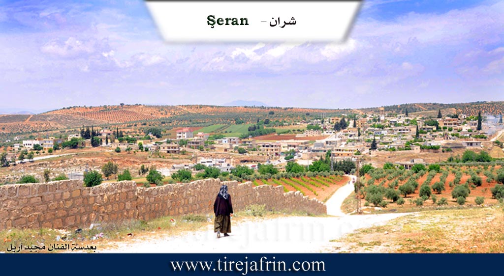
The town of Şera is located on the western slope of a limestone plateau. It is 13 km from the city of Efrîn in a northeasterly direction. The settlement of the area is ancient, evidenced by the presence of huge trimmed limestone blocks, tombs, and wells carved into the rock dating back to the Roman era. It is bordered by the village of Xirbe Şera to the south, which is the old village; they are separated by Wadiyê Entûz (Entûz valley) coming from the east. The residents work in agriculture as a main resource; the town is surrounded by olive groves and fruit orchards. It contains commercial shops and small workshops for maintenance, blacksmithing, carpentry, building materials, and olive presses. Şera is a beautiful town; its dwellings slope gently toward the west and south, and some modern buildings in the form of elegant villas have begun to appear.
According to the book Efrîn... Her River and Her Green Hills:
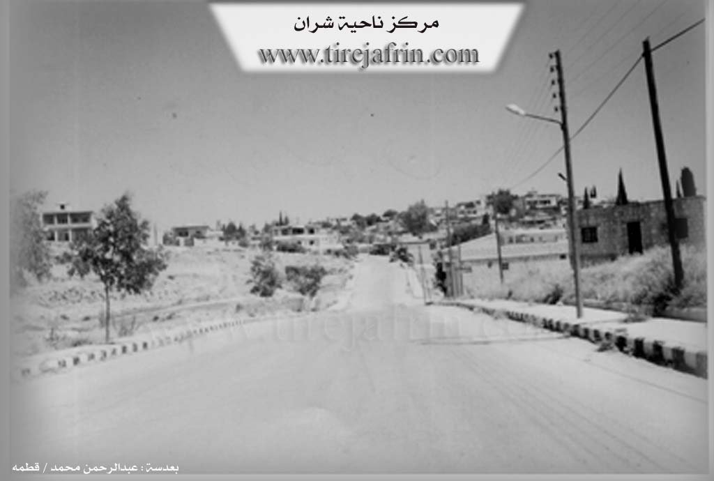
Şera District: This is the center of the district, with an area of 331.35 km². Its population, according to the civil registry on December 31, 2004, is 50,897 souls. It is bordered by the Ezaz region to the east, the villages of the Navenda Efrînê district to the south, the districts of Mabeta and Bilbil to the west, and the Turkish border and villages of the Bilbil district to the north. 37 villages and 7 farms are administratively attached to it. The district was created according to the administrative divisions of 1975. The Girê Mixferê (The Station Hill) was an important center for French forces during the French Mandate over Syria. We will speak in detail about each village belonging to the district separately.
The Town of Şera:
A town in Çiyayê Kurmênc, it is the district center, belonging to the Efrîn area, Heleb governorate. The town of Şera is located in the northeastern part of Çiyayê Kurmênc, on the western slope of a limestone plateau at an elevation of 500m. It is an old village that slopes slowly toward the south. Wadiyê Sîlê (Sîlê valley) passes in front of it, heading toward the valley of Çemê Efrînê (Efrîn River). Its soil is fertile clay. It is approximately 13 km from the city of Efrîn heading northeast. The settlement of the area is ancient, evidenced by the presence of huge dressed limestone rocks, tombs, and wells carved into the rock dating back to the Roman era.
It is bordered to the north by mountainous highlands planted with olive trees and the village of Ceman; to the south by a slope, Wadiyê Sîlê, Xirbe Şera, and the village of Matîna at a distance of 1 km; to the east by a slope, a valley, a fertile plain planted with olive, walnut, and pomegranate trees, and the village of Sînka at a distance of 1 km; and to the west by mountainous highlands planted with olive trees and forest trees, and the village of Kubelek.
The number of its houses is about 110, and its age is approximately 500 years. Its old houses are made of stone and mud with wooden ceilings, while the modern ones are stone and cement. Some modern buildings in the form of elegant villas have begun to appear toward the western and northern sides and on both sides of the main street in the center of the town, starting from the south at the first entrance of the town near Xirbe Şera at the Qewsa Nesrê (Arch of Victory), along with several luxurious villas on both sides of the road.
The population of the town at the end of 2004 was about 2500 people, and the total population of the district was 50,897 people. An electricity network is available, as well as a primary, middle, and secondary school. It contains an old mosque, a post and telephone center, a health center, a recruitment branch, a party branch, a very old police station (Mixfer), a building for the district directorate, and a municipality hall. There is also one technical olive press and several ordinary presses. It has commercial shops and small workshops for maintenance, blacksmithing, and the sale of building materials.
The town's residents work in rain-fed agriculture (olives and grains) and irrigated agriculture from artesian wells (walnuts, apples, cherries, and summer vegetables), alongside raising sheep and goats. The town drinks water from a water network connected to the artesian well south of the town at the bottom of the valley. There are several asphalted streets, and the town is connected to the regional center by an asphalt road that passes through its center to several neighboring villages.
Şera is a beautiful town whose houses tilt with a gentle slope toward the west. Among its most important families is the family of Menan Axa Celosî; they were the first to inhabit the village. Its population according to the civil registry on December 31, 2004, is 2332 souls. The first to undertake the administration of the Şera district directorate was Lieutenant Colonel Ebdulqadir Xetîb.
Families in the village:
Celosî, Eynalo, Îbiş, Qereman, Mûsilî, and Me'dan (Şe'bo).
Village Mukhtar: Cemal Cabo.
Sources of Information:
- Book: جبل الكرد (عفرين) دراسة جغرافية Çiyayê Kurmênc (Efrîn): A Geographical Study by د. محمد عبدو علي Dr. Mihemed Ebdo Elî.
- Book: عفرين .... نهرها وروابيها الخضراء Efrîn... Her River and Her Green Hills by عبدالرحمن محمد Ebdulrehman Mihemed from the village of Qetme.
- Studies of Navenda Tirej Soft / Ebdulrehman Hacî Osman.
- Some residents of the villages.
Preparation and execution: Manager of the Tirej Efrîn website, Ebdulrehman Hacî Osman, 20/12/2013.
II. Summary of Şera from Multi Channel
The village of Şerran is located fifteen kilometers northeast of Efrîn and serves as an administrative center. It was established over four hundred years ago while its original ruined settlement is over five hundred years old. The earliest inhabitants belonged to the Şîkaka tribe who migrated from the city of Urfa in southeastern Tirkiye. They were originally nomadic koçer herders. Upon arrival they settled in the caves and valleys around Xirabê Şerran because of the abundant water springs and forests in that specific area.
Later a violent conflict broke out with other shepherds over control of the water and grazing lands near Çiyayê Qitmê. The Şîkaka herders laid an ambush that lasted from midnight until dawn resulting in many casualties. The site of this battle became known as Geliyê Kuştiyan which translates to the valley of the killed and it is located between Metînli and Xirabê Şerran. Following this conflict the community split. Some remained in the ruins while others moved to the current location of Şerran to secure the water sources from both sides and protect their livestock.
Over the centuries the village grew to include various families living harmoniously. The Kurdish families include Cilûsî and Çoxdar and Sîdo Reşo and Dûdex and Hesko and Haşim and Elî Mûsa and Hemo Kan and Me'den and Turk and Înalo and Qereman. There is also an Arab family named Uqle. The residents share a history of intermarriage and mutual support. Historically the village maintained stronger trade relations with Ezaz than with Efrîn because Ezaz is a much older trading hub.
The community is deeply committed to preserving its cultural heritage. In the year two thousand they formed the Şîkaka folklore troupe. They perform traditional dances like Mewlanî and Çîftetelî and Dokuzlu which reflect an old cultural exchange from their time in Tirkiye. Their traditional attire features a distinctive pierced hat called a kumê qulik. Historically worn by farmers for ventilation this hat is said to loosely resemble the dome of the sacred Êzîdî shrine in Laliş.
The village contains several historic landmarks. The ancestral home of elder Ebdilmenan Yûsif Hesko dates back over one hundred and eighty five years. Its traditional ceiling was built using poplar wood transported on camels from Gawir Dax. Today the residents continue to practice their local traditions including making local cheeses and cooking dishes like dolma while adapting to the arrival of displaced families from places like Hims and Heleb and Idlib and Dera and Şam.
II. Summary of Şera from Multi Channel 2
The documentary explores the district of Şêran, also referred to as Şera, situated in the Efrîn region, known historically as Çiyayê Kurmênc. The district is highly regarded for its agricultural wealth, particularly its high quality olive oil, which is famous throughout Efrîn.
The village has deep historical roots stretching back to the era of the Ottoman Empire, referred to locally as Dewleta Alî Osman. An elder named Evdilmenan Yûsif, also known as Heso, shares that the ancestors of the Şikak tribe migrated to the area due to conflicts. The tribal leader Îsmaîl Simko Axa and figures like Hamza Beg and Mîre Zirav were involved in disputes that caused the Şikak to scatter. Some moved toward Îran, others settled between Çiyayê Bêxêr and Şengal in Iraq, while a pastoral group arrived in the empty wilderness of Efrîn to plant olives. The elder explains the name Şêran comes from a village in the Şengal mountains named Şêra. Under Arab administration, the name was altered to Şêran, while the Turk authorities previously called it Şeranli.
The primary tribe in the district is the Şikak tribe. This large confederation contains several branches and families that established the local communities, including the lineages of Hesokê, Dûmiliya, Qûse, Xelbaş, Sebeb, Hesek, Dûmirliya, Hemdûş, Hemkûlik, Selmîn, and Malê Çopan. Another resident, Huseyîn, mentions belonging to the Ebo Kelewa tribe.
A notable historical feature in Şêran is an ancient underground olive press known as the Meqbes. According to the local mukhtar Îbrahîm Îbrahîm, this press is hundreds of years old and was carved directly out of stone, leading some to mistake it for a cave. The district also has ancient trees. Huseyîn protects a massive oak tree which is well over a century old. During the French mandate, local militiamen would hide in a cave beneath this very tree.
To preserve local history, Evdilmenan Yûsif transformed his ancestral home into a museum showcasing Kurdish heritage, displaying old agricultural tools and portraits of iconic Kurdish leaders like Şêx Seîdê Pîranî, Qazî Mihemed, Seyîd Riza, and Mela Mistefa Berzanî. The village holds a strong cultural identity, with local dance groups traveling to Kurdistan in 2010 to perform traditional dances at Keleha Şêrwan and Laliş. Residents like Ciwan Ebdo Tirik and Eymen Kurd Ebdê also showcase the ongoing cultural and economic vitality of Şêran, producing music and exporting local agricultural products across Sûriyeyê to cities like Heleb, Qamişlo, and Şam.
Transcriptions and Subtitles
| Source | Video | Subtitles | Transcript |
|---|---|---|---|
| Multi Channel 1 | Watch Video | Download SRT | View Transcript |
| Multi Channel 2 | Watch Video | Download SRT | View Transcript |
Foundation/Origin Information of Şera
The first to inhabit the village was the family of Manan Agha Jelosi.
Source: TirejAfrin Site
Possible Village Name Meaning of Şera
Şer means fighting in Kurdish. And Şarri in the ancient Hurrian language means king/leader of the people.
Source: TirejAfrin Site
V. Links
- Tirej Afrin:
https://www.tirejafrin.com/site/kura%20afrin%20%20sheran%20-%20sheran.htm - Ax û Welat:
https://www.youtube.com/watch?v=VXIFN4UMLM4 - Jawlat:
https://www.youtube.com/watch?v=N_0kF7Z6PAQ - Video:
https://www.youtube.com/watch?v=3WEDp3h_-Go - Link:
https://www.youtube.com/watch?v=Zgbel9mNKIQ - Link:
https://www.youtube.com/watch?v=FDWu0VqT7ro - Link:
https://www.youtube.com/watch?v=5s9WesQfOTc - Link:
https://www.youtube.com/watch?v=e4PnRvkJyQI - Local FB page:
https://www.facebook.com/jxhfi - Multi Channel:
https://youtu.be/vKSkmy8P4Q0?si=73zG1TZhqTjiyd41