General Information
Nahiya (Subdistrict)
Efrîn
Also Known As
Iska, Iskan, Kurmêz, Îska, إسكان, اسكان, ايسكو
Tribes
Xezewî, Şerawa
Families, Clans, etc.
Arif Îbiş Axa, Bikro, Birko, Birîmo, Biş Axa, Ehmed Axa, Eloko, Emo, Emê, Eseed Axa, Heso, Heyder Axa, Kinc, Koro, Mala Apê, Mala Elo, Mala Elî, Mala Elî Mêrzo, Mala Hembazikê, Mala Omê, Mala Qadirî Berko, Malê El'emo, Mistê Eloka, Xalid Axa, Xalit Axa

Photos
Basic Information about Îska
Source: Ax û Welat
Etymology: Derived from the word Îseken meaning settled or gathered, though some say it is named after a girl formerly known as Çemê Şîn
Foundation Date/Period: Pre Roman era origins; modern settlement established circa 1740
Caves: Şikefta Dêlik Mûxar
Springs: Kanî Dînka, Kaniya Kêndînkê, Kanî Kerkê, Kanî Gewrkê, Kaniya Mezin, Kaniya Biçûk
Hills: Teqlike, Çiyayê Lêlûn
Shrines: Kanî Dînka, Şêx Ebdulhemîd
Ruins: Keleha Heyder Axa Pîr, Keleha Seman
Wells: Bîra Keua
Other Landmarks: Deşta Cûmê
Summaries
I. Summary from TirejAfrin Site (English) of Îska
Source: https://www.tirejafrin.com/site/kura%20afrin%20markaz-%20iska.htm
Based on the book جبل الكرد (عفرين) دراسة جغرافية Çiyayê Kurmênc (Efrîn): A Geographical Study by د. محمد عبدو علي Dr. Mihemed Ebdo Elî, regarding Iska:
Population: 1812 inhabitants. Area: 1200 hectares. Distance: 20km. Elevation: 210m.
The Emo family states that they were the first to inhabit its site, and it was named at that time "Kan" or "Iskan", meaning the place of dwelling.
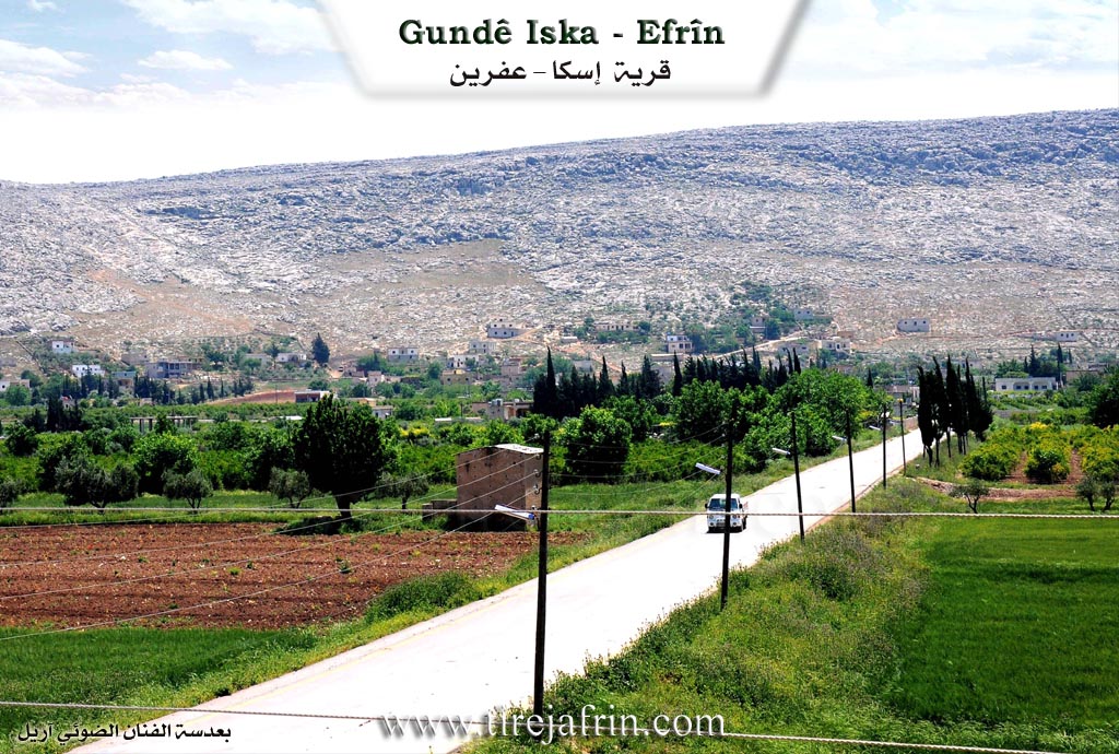
Iska is a large and prosperous village. It contains a veterinary health center and an agricultural extension unit. It is home to the ancient Xalid Axa family from the Kinc lineage, dating back to the eighteenth century. On the eastern side of the village, on the mountain slope, lie the ruins of Teqilke at a site called Kan Dnk, which date back to the Greek eras and were formerly a residence for the Emo family. To the west of the village lies the Iska spring, with a flow rate of 28 liters per second.
According to the book عفرين .... نهرها وروابيها الخضراء Efrîn... Her River and Her Green Hills by the writer عبدالرحمن محمد Ebdulrehman Mihemed from the village of Qetme:
Iska is a village in the Efrîn valley, administratively belonging to the Central Villages subdistrict of the Efrîn region, Aleppo governorate. It is a large village located at the end of the northwestern slope of Çiyayê Te'baniye. To the northwest of the village is a small plain crossed by a seasonal flood valley that begins northwest of the village and ends in the valley of Çemê Efrînê (Afrin River). Its soil is clay like. It is located 25km southwest of the city of Efrîn.
Its boundaries are: to the north, a fertile agricultural plain, the valley of Çemê Efrînê, and the village of Ferîriye; to the south, the rugged Çiyayê Sem‘ên range composed of rocks; to the west, a mountainous elevation and the village of Celemê; and to the east, a fertile plain, Eyn Mecnûn, and the village of Şêx el-Dêr.
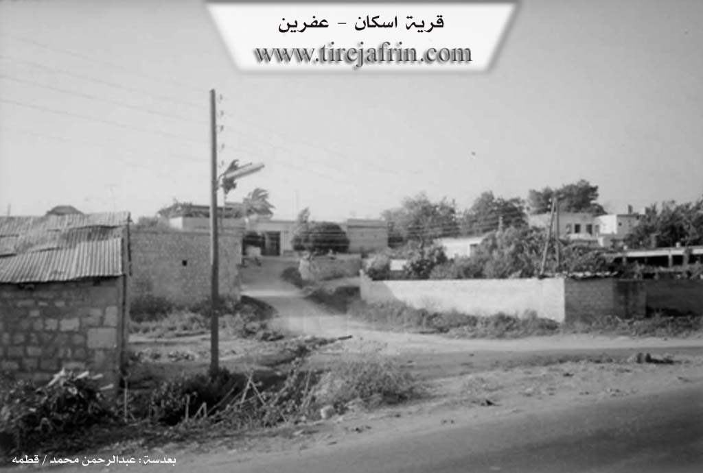
The number of its houses is approximately 175, and its age is about 400 years. Its old dwellings are constructed of stones and mud with wooden ceilings, while the modern ones are made of stones and cement. It is served by an electricity network, drinking water drawn from a well south of the village, telephone lines, an agricultural extension unit, a primary school, and a small mosque located on the southwestern side of the village. An asphalt road passing through the center of the village connects it to Efrîn and neighboring villages.
The residents work in the cultivation of grains and rain fed vegetables. Residents also cultivate irrigated cotton and sugar beets, as well as pomegranates, walnuts, apples, and other fruit trees. Water comes from artesian wells and Çemê Efrînê. There is also a spring on the western side of the village. The village belongs to the municipality of Xezawiyê. Residents also work in raising sheep, cows, and goats. Among its most important families are the family of Xalid Axa, Heyder Axa, and Arif Îbiş Axa. Attached to it is the farm of Eyn Mecnûn, located one kilometer east of the village.
Village Mukhtar: Cemal Birko
Preparation and execution:
Manager of Tirej Efrîn site: Ebdulrehman Hacî Osman
20/12/2013
Sources:
- Book: جبل الكرد (عفرين) دراسة جغرافية Çiyayê Kurmênc (Efrîn): A Geographical Study by د. محمد عبدو علي Dr. Mihemed Ebdo Elî.
- Book: عفرين .... نهرها وروابيها الخضراء Efrîn... Her River and Her Green Hills by عبدالرحمن محمد Ebdulrehman Mihemed from the village of Qetme.
II. Summary of Îska from Ax û Welat
Source: https://www.youtube.com/watch?v=xFHPrwyRsoY
The village of Îska is a historically significant settlement located in the Şêrewa district of the Afrin region. Situated at the foot of Çiyayê Lêlûn and facing the fertile Deşta Cûmê, the village has ancient roots that residents trace back to the Pre Roman era. The area contains Roman era ruins and caves that suggest long term habitation. Elders describe the modern iteration of the village as being founded approximately two centuries ago, or specifically around 1740, when families descended from highland fortifications like Teqlike to settle in the valley. The village was historically known as Çemê Şîn due to the abundance of water and greenery before adopting the name Îska, which some locals attribute to the word "Îseken" meaning a place of gathering or settlement.
Two primary lineages established the modern village structure. Mala Apê is cited as the first family to arrive around 1740 after being exiled or displaced from Turkey during conflicts involving the Ottomans. They were soon joined by Mala Elo. Over time these families expanded and were joined by others such as Mala Elî Mêrzo, a family belonging to the Êzîdî faith. The village is noted for the harmonious coexistence between its Muslim and Êzîdî[[]] residents who share in social obligations and festivities without division. Other families mentioned include Malê El'emo and Mala Qadirî Berko.
Water sources define the geography and spiritual life of Îska. The village served as a caravan stop between Anatolia and Heleb because of its abundant springs. Notable springs include Kaniya Mezin, Kaniya Biçûk, Kanî Kerkê, and Kanî Gewrkê. The most significant spring is Kanî Dînka, also referred to as Kaniya Kêndînkê. This site functions as a shrine or Ziyaret where locals light candles and perform prayers on Wednesdays and Fridays. Residents believe the water has healing properties. Nearby stands the ancient well Bîra Keua, which is believed to have a subterranean channel connecting to the historic Keleha Seman. On the hill of Teqlike above the village lies the ruin of Keleha Heyder Axa Pîr, linked to the historical figure Ehmed Axa of Mala Omê.
Îska is regionally famous for its agriculture, particularly its pomegranate orchards. The production of pomegranate molasses, or dimis, is a major communal activity involving many families. Culturally, the village is renowned as the home of the late dengbêj Mihemedê Elî Kûrê, a celebrated traditional singer whose family still resides there. The community also honors recent history, naming their commune after Şehîd Şêx Adî and a school after the martyr Cîwan Efrîn.
II. Summary of Îska from Multi Channel
The documentary provides an in depth look at the village of Îskan, located in the Efrîn region. The village sits on the northern slopes of Çiyayê Seman, bordered to the south by Çiyayê Lêlûn, to the east by Şêx Dêr, and to the west by Cilmê. It is located fourteen kilometers southeast of Cindirês and is administratively part of the Xezawiyê district. The population consists of over five thousand residents, including two hundred and ten Kurdish Muslim and Êzîdî families. Due to recent conflicts, the village also hosts over nine hundred displaced Arab families from Idlib and Heleb, including individuals like Arif El Hemîd from Fitêra in Çiyayê Zawiyê.
Historically, Îskan is a relatively modern settlement, founded approximately three hundred years ago. According to local historian Xalid Elo, the surrounding area has ancient roots tied to Byzantine times. The first settlers were the Emo family, who initially lived in the eastern Byzantine ruins known as Teqelka. Similarly, the Mistê Eloka family originally resided in a large cave behind Çiyayê Lêlûn. Both families eventually moved down to the current village location to be closer to the vital water sources. They were later joined by the family of an early mukhtar named Ebdulqadir Birko, as well as the Heso and Bikro families. The Bikro family migrated to the village from Kefer Nabo. The oldest surviving home in the village belongs to Xalid Îbiş from the Emo family, showcasing traditional arched architecture built with mud and thick walls.
The village is sustained by significant natural landmarks. Two main springs, Kaniya Biçûk and Kaniya Mezin, provide water that eventually flows into Çemê Efrînê. In addition to the ancient ruins of Teqelka, the nearby area features multiple caves collectively known as Neoska. Agriculture forms the backbone of the local economy. Farmers like Şukrî Mihemed Birîmo cultivate pomegranates, pears, olives, and various grains, though many struggle with rising costs and difficult market conditions. The current mukhtar, Mehmûd Omer Eloko, notes the transition from traditional rainfed crops like wheat and barley to irrigated fruit orchards following the drilling of numerous artesian wells.
A notable site at the entrance of Îskan is the villa of the late traditional Kurdish singer Mihemed Elî Koro. His son, Necîb Mihemed, maintains the property, which includes a beautiful garden built directly over the main village spring. Mihemed Elî Koro was famous throughout the Kurdish regions for performing at weddings and social gatherings. He passed away in two thousand and fourteen and is buried on the estate. The musical tradition lives on as residents continue to play the buzuq and sing old Kurdish folk songs. One such historical song recounts the story of an ancestor named Xwarezim Hemed, who composed a moving lament after the tragic death of his young nephew Mihemed. Through its rich history, distinct architecture, and strong cultural roots, Îskan remains a vibrant agricultural and artistic community.
II. Summary of Îska from Multi Channel 2
The village of Îska, located twenty three kilometers from the city of Efrîn and near Cindirêsê, is a historic settlement founded around 1740. According to the village leader Mehmûd Omer Eloko, the original founders were the Emê family, who migrated from the Iskenderûn area to Basûtê before finally settling in Îska. The village was subsequently shaped by prominent landowning families, including the lineages of Ehmed Axa, Heyder Axa, Xalit Axa, Eseed Axa, and Biş Axa. The Eloko family arrived shortly after. In its early days, the local economy relied heavily on livestock and agriculture, with villagers traveling on horseback to Heleb to sell cheese, yogurt, butter, and grain.
The social structure of Îska was traditionally anchored by the Axa families who managed vast estates. These prominent figures built large guest houses to host villagers, farmers, and travelers since traveling to Heleb was difficult. They acted as social pillars, settling local disputes impartially and providing financial aid for marriages or medical emergencies. A surviving testament to this era is Qonaxa Ehmed Axa, a grand mansion constructed between 1940 and 1942. Designed with French architectural influences, the mansion featured ten rooms and large windows. Notably, the kitchen was kept separate from the main building to prevent cooking odors from reaching the guests. Although later damaged by an earthquake, the structure remains a vital piece of local history.
Îska is also known for its historical infrastructure and natural resources. The village is sustained by three main water sources: Kaniya Dîn, Kaniya Çûçik, and Kaniya Mezin. Historically, it served as an educational hub for the region. Xalit Axa established a regional school in the village, drawing students from neighboring settlements such as Celeme, Keferzîte, Şateliqê, Şadêrê, and Xezwiyê. This emphasis on education created a legacy of highly educated residents. Arifê Biş was the first in the village to earn a baccalaureate degree and become a doctor. He was followed by many others, including Doktor Heyder Omer who studied in Canada, and Doktor Ehmed Fuad Omer who studied in France. Today, the village boasts numerous doctors, engineers, and lawyers.
Agriculture remains the lifeblood of Îska. Villagers cultivate peppers, watermelons, pomegranates, pears, and olives. The village has a reputation for agricultural innovation within the region. Recently, a modern crop sorting facility was established to clean seeds and grains for surrounding farmers. Additionally, the village is home to a historic stone mill used for processing wheat into bulgur. This mill is considered one of the oldest of its kind in the Efrîn area, predating similar mills in Celeme and Basûtê. The deep historical memory of the village is embodied by elders like Emîna, a centenarian who recalls the intense poverty and hard labor working on roads during the French mandate period, highlighting the incredible endurance and transformation of the community over the past century.
II. Ax û Walat Book 1
149
THE VILLAGE OF ÎSKA
12.10.2016
The village of Îska is affiliated with the Şêrewa district of the Efrînê canton, located 20 km southwest of the city of Efrînê and 10 km west of the town of Basûtê.
The name of the village comes from the name (Qîzkê). It was built on an ancient historical site.
The Umê family was the first family to settle in the village. The village of Îska is located at the foot of the LÊLÛN mountain and in front of the Cûmê plain. It is the last village of the Şêrawa district on the southwest side.
150
The village of Îska is composed of both Êzdî and Misilman components, and both components live in harmony and good relations.
To the east are the village of Şadêrê and the Lêlûn mountain range, to the south are the Lêlûn mountain and the town of Darazê, to the west is the village of Celemê, and to the north are Kanî Dînk, the Cûmê plain, and the villages of Firêriyê and Keferzîtê.
The Castle of Heyder Axayê Pîr is to the east of the village, on the mountain above the village in an area called ((Teqilkê)). It is thought that Ehmed Axa was one of the Umê family.
The village of Îska was famous for its springs, and it had become a place and resting stop for caravans of travelers who were going from Anatolia to Helebê. The Mezin Spring is to the west, the Biçûk Spring is in the village, and the Dînkê Spring is to the east of the village.
The Kewa Well is an ancient and very deep well; it is not known when it was dug. It is believed that a canal under the ground goes from that well to the Sem’anê citadel.
There are many caves in the village that are used as storage for houses or as places for livestock.
The Dêlik Muxer cave is a cave with 7 levels and is very ancient. The sheep of all the village families were housed there.
151
There are 16 families in the village:
The family of Umê, Mistê Eloko, Elo Xirfano, Hembaskê, Evdal, Hemoyê Ehmed Xelîl, Ehmoyê Qesêb, Xelîlê Hemêş, Mihemedê Îdo, Remo, Eliyê Xelo, Elkûrê, Zerîfê, Reşo, Ezetê Bedîna, and the family of Xemîs.
About 250 houses and around 2000 people live in the village.
The people of the village make their living from agriculture, primarily from vegetable gardens, due to the availability of water sources from springs, wells, and dam canals. The village is also famous for fruit trees such as pomegranates, peaches, apples, pears, and apricots. But there are few olive trees.
Some families own livestock like sheep and cattle, and they sell their products like cheese and yogurt in the markets of the district and Efrînê. Some people in the village also keep honeybees.
Farmers plant a large amount of grain such as wheat, barley, chickpeas, lentils, and fenugreek around the village and make their living from it.
About 20 people also work in the institutions and bodies of the Autonomous Administration in Basûtê and Efrînê.
There is a martyr from the village named Ciwan Efrîn, and the village school has been named after him. The village commune is also named Ş. Şêx.
152
Mihemed Elkûrê was known as a folk singer, and he contributed a great deal to the development of the art of folk singing in the region. He passed away in 2012.
Şêx Evdal was a well-known and famous scholar of the Islamic religion, and he did a lot of work in this field.
It is worth mentioning that the village has relatives in the villages of Celemê, Basûtê, Xezewê, and Firêriyê.
Transcriptions and Subtitles
| Source | Video | Subtitles | Transcript |
|---|---|---|---|
| Ax û Welat 1 | Watch Video | Download SRT | View Transcript |
| Multi Channel 1 | Watch Video | Download SRT | View Transcript |
| Multi Channel 2 | Watch Video | Download SRT | View Transcript |
Foundation/Origin Information of Îska
The Al-Ammo family says they were the first to settle in its location. It contains the ancient Khalid Agha family from the Al-Konj family from the eighteenth century.
Source: TirejAfrin Site
Possible Village Name Meaning of Îska
It was named "Kan" or "Iskan", meaning place of residence.
Source: TirejAfrin Site
V. Links
- Tirej Afrin:
https://www.tirejafrin.com/site/kura%20afrin%20markaz-%20iska.htm - Ax û Welat:
https://www.youtube.com/watch?v=L41I3SPpv3A - Jawlat:
https://www.youtube.com/watch?v=TCXgEByGbsI - Video:
https://www.youtube.com/watch?v=i2DL-0hE8-s - Ax û Welat:
https://www.youtube.com/watch?v=xFHPrwyRsoY - Multi Channel:
https://youtu.be/Obb97EkZXP0?si=Eua7UMWDMAbmpZZH