General Information
Nahiya (Subdistrict)
Efrîn
Also Known As
Keferzît, Keferzîtê, كفر زيت, كفرزيد
Tribes
Benî Zêd, Bêrkan, Bûbena, Omeran, Xastiyan, Şikakî
Families, Clans, etc.
Abdo, Bilalê Hemo, Bêrem, Cafo, Cined, Denadîle, Hamekerro, Hec Bettal, Hisî Berko, Kilepçêk, Kolo, Mehmûd, Nasirê Derwêş, Osman, Silêman, Xoca, Şemî, Şênê

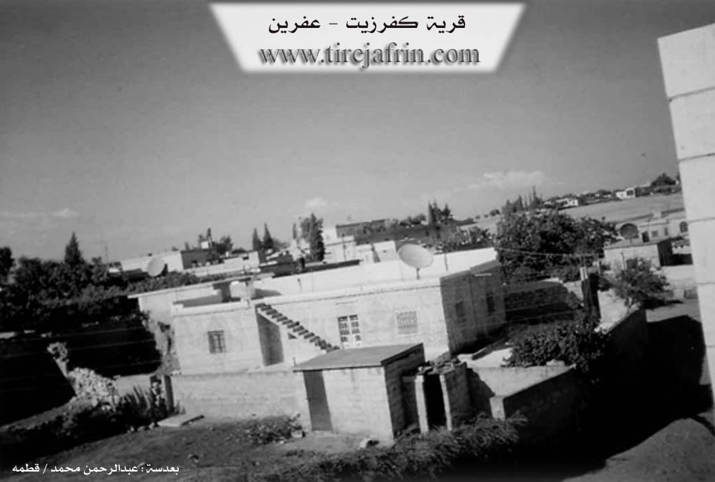
Photos
Basic Information about Keferzîtê
Source: Afrin Flo
Foundation Date/Period: late 18th or early 19th century
Hills: Çiyayê Lêlûn
Other Landmarks: Sêdê Meydankê, Deşta Cîmê, Ziravkê, Qemerîkê
Summaries
I. Summary from TirejAfrin Site (English) of Keferzîtê
Source: https://www.tirejafrin.com/site/kura%20afrin%20markaz-%20kefezete.htm
It is stated in the book جبل الكرد (عفرين) دراسة جغرافية Çiyayê Kurmênc (Efrîn): A Geographical Study by د. محمد عبدو علي Dr. Mihemed Ebdo Elî: Keferzît, Kefer Zeyt or Keferzîd / 1266 inhabitants 542 houses 15km 300m /:
The name is a compound of: Kefer + Zeyt or Zêd, and "Zêd" means prominent and projecting (zêd) in the Kurdish language /Dictionary of Kurdistan/. The location of the village on the high slope is consistent with the name. Also, Zeyt or Zêd is an Eastern Syriac word meaning "oil," and for that reason, the name might mean: Village of Oil.
It is a large village located on the higher southern slope of a limestone height that overlooks the northern bank of the river of Efrîn, at a distance of 1.5km from it.
It is stated in the book: عفرين .... نهرها وروابيها الخضراء Efrîn... Her River and Her Green Hills by the writer عبدالرحمن محمد Ebdulrehman Mihemed from the village of Qetme: Keferzît is a village in Çiyayê Kurmênc, administratively belonging to the villages of the center of the Efrîn district, Heleb governorate.
It is a large village situated atop the higher southern slope of the limestone mountain of Merzayet. The slope overlooks the river of Efrîn from the northern bank of the river. It is bordered to the north by a slope and a plain that is agriculturally fertile and planted with olive trees, and the village of Tilelf; to the south by a slope, a plain, the watercourse of the river of Efrîn, and the village of Xezawiyê in the far south; to the east by a slope, a fertile plain planted with olive trees, and the villages of Kewkebê and Kefîrê; and to the west by a slope planted with olive trees and the village of Firêriyê and Til Hemo.
The number of its houses reaches about 300 houses and its age is about 500 years. Its old residences are of stone and mud with wooden ceilings, while the modern ones are of stones and cement and have spread to the outskirts of the village. An electricity network, a primary school, a small mosque, and a paved road up to the center of the village are available in it. The residents drink from a network that draws its water from the well located northeast of the village of Xezawiyê.
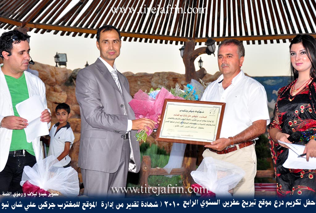
Its inhabitants work in the cultivation of grains, vegetables, olive trees, and other fruit trees, and they raise sheep and goats primarily. Its lands are agriculturally fertile on the southern and eastern sides due to their proximity to the watercourse of the river of Efrîn. It is mentioned that the expatriate Cerkîn Nebo, who contributed to the annual honoring ceremonies of the Tîrêj Efrîn site, is among the sons of this village.
Village Mukhtar: Hesen Kalo Elî
Preparation and Execution:
Manager of the Tîrêj Efrîn site: Ebdulrehman Hacî Osman
20/12/2013
Sources:
- Book: جبل الكرد (عفرين) دراسة جغرافية Çiyayê Kurmênc (Efrîn): A Geographical Study by د. محمد عبدو علي Dr. Mihemed Ebdo Elî.
- Book: عفرين .... نهرها وروابيها الخضراء Efrîn... Her River and Her Green Hills by عبدالرحمن محمد Ebdulrehman Mihemed from the village of Qetme.
II. Summary of Keferzîtê from Afrin Flo
Source: https://www.youtube.com/watch?v=cFGV39fmdBU
The village of Kurzêlê, also referred to as Kurzêlê Cûmê, is situated in the Deşta Cîmê plain within the Çiyayê Kurmênc region. The settlement possesses a deep rooted social history marked by the long standing presence of specific lineages. According to local residents, the core families have inhabited the village for approximately 200 to 250 years, suggesting a stable population established around the late 18th or early 19th century. While the village contained between 700 and 750 households prior to 2010, the conflicts in Syria and subsequent displacement reduced this number to around 500 households by the time of filming.
The social structure of Kurzêlê is defined by several large, established families rather than a single tribal affiliation. Prominent lineages identified in the village include the Kilepçêk, Bilalê Hemo, Şemî, Bêrem, and Osman families, with the latter also known locally as Xoca. Another significant group is the Hamekerro family, which is also referred to as Şênê. The Abdo family is notably active in the village's agricultural development, particularly in the field of apiculture. Additionally, the Mehmûd family is mentioned as a resident household. These families have historically placed a high value on education, with a legacy of sending children to study that dates back to the 1960s, producing teachers, doctors, and engineers.
Historically, the village practiced social customs such as bardêl or bride exchange, where families would exchange daughters in marriage to avoid paying a dowry. Elders recount that this practice sometimes involved exchanges between villages across the region, where meeting points on bridges or roadsides served as the location for swapping brides. Another historical custom mentioned was elopement, which served as an alternative to arranged marriages and often required subsequent reconciliation efforts between families.
The economy and daily life of Kurzêlê are historically agrarian, heavily reliant on the cultivation of olives, eggplants, peppers, and okra. The village faces contemporary challenges regarding water access, specifically linked to the water levels of the Sêdê Meydankê. A distinctive feature of the village's recent economic history is the development of professional beekeeping. This industry was pioneered in the village during the 1980s by the father of resident Rezan Abdo, who introduced scientific methods and expanded the practice from a few household hives to a significant local trade. The surrounding geography includes views of Çiyayê Lêlûn opposite the plain, while songs associated with the region reference nearby locations such as Ziravkê and Qemerîkê.
II. Summary of Keferzîtê from Multi Channel
The village of Kefer Zêt is situated in the fertile Deşta Cûmê region, southwest of Efrîn and close to the banks of the Çemê Efrînê. Its name derives from the ancient Syriac language, combining the words for village and olive, perfectly reflecting its enduring agricultural legacy. Although the site has been associated with olive cultivation for over five centuries, it was largely an abandoned ruin until roughly 150 years ago. At that time, nomadic Kurd pastoralists seeking water and grazing lands for their livestock settled the area.
The village was primarily repopulated by members of the Xastiyan and Bêrkan tribes. The Xastiyan, which includes the Denadîle lineage, migrated down from the village of Birc Heyder located on Çiyayê Lêlûn. Meanwhile, the Bêrkan presence traces back to a single family that arrived 150 years ago from Sînka, located in the Şikakî area of the Şera district. Historically, the residents of Kefer Zêt followed the Êzîdî faith. Over the last century, the majority gradually converted to Islam, though a handful of Êzîdî households still remain in the village. In the past, the Êzîdî community would bury their deceased in an ancient Zerdeşt cemetery in the nearby village of Şadêr.
Socially, the inhabitants of Kefer Zêt maintain strong kinship and marital ties with neighboring villages such as Birc Ebdalo, Xezawiyê, Îskan, and Birc Heyder. The local Kurd population has also shared a long history of coexistence, joint agricultural labor, and intermarriage with regional Arab tribes. Notable among these are the Omeran, who have lived in surrounding settlements like Frêriyê, Kawkebê, and Basûtê longer than other Arab tribes such as the Benî Zêd and Bûbena. Today, the village has expanded to include hundreds of displaced individuals from the Hema and Idlib regions, who work alongside the locals in the olive groves.
The architecture of Kefer Zêt has evolved significantly. Early homes were constructed from simple mud and wooden pillars. Later, residents began utilizing local calcareous stone quarried from the eastern side of the village. A prominent example is the surviving stone house built in the year 1958 by a builder named Merwan Hesen from Barad for a local man named Nasîr Derwîş. By the year 1990, modern cement construction replaced these older methods to prevent roof collapses during heavy rains. Before 2011, water was supplied to the village from Xezawiyê.
Agriculture remains the heart of Kefer Zêt. The village boasts tens of thousands of olive trees, alongside pomegranate orchards and diverse vegetable gardens. Women like Um Ehmed keep culinary traditions alive, baking fresh flatbread on a traditional iron saj and preparing local specialties like muhammara seasoned with fresh ingredients from their home gardens. While baking, she shared a traditional Kurmanji song mentioning the city of Heleb. The village is characterized by a strong sense of community, where residents assist one another during harvests, weddings, and funerals, maintaining the welcoming and generous spirit of their ancestors.
II. Summary of Keferzîtê from Multi Channel 2
Located between Efrîn and Cindirêsê, the agricultural village of Keferzîtê was founded approximately three centuries ago. The local mukhtar, Zuheyr Mihemed, explains that the village name has deep historical roots. The word Kefer comes from a Roman term meaning farm or settlement, while zeyt refers to olive oil. In the past, the village served as a major center for olive oil production and was known for its large stone presses.
The earliest settlers who established the village were the Hisî Berko and Nasirê Derwêş families. They were soon joined by the Kolo family. Over time, other families migrated from outside areas and settled in the village, including the Silêman, Hec Bettal, Cined, and Cafo families. Today, the village comprises about 170 households. The community is highly integrated through intermarriage, resulting in strong social bonds. The village is home to both Muslim and Êzîdî residents. The Êzîdî families originally migrated from the village of Sînka. They were warmly welcomed into Keferzîtê and share fully in all local traditions, festivals, and community obligations without any social division. Other residents have also relocated from the nearby village of Keferdelê.
The local economy relies heavily on agriculture, specifically olive farming, vegetable cultivation, and livestock. However, the region has faced severe economic and social stagnation since 2018. Many educated residents, including former teachers, are currently unemployed. The local school only offers classes up to the sixth grade, meaning older children must travel to private schools elsewhere to continue their education. Despite these hardships, residents maintain their cultural heritage. Women like Aîşe, who originally comes from Birc Ebdalo and married into the village of Mêrskê, preserve customary culinary practices like making kutayî, a hearty winter dish prepared by laboriously pounding wheat and cooking it with meat.
The documentary also delves into the grim political history of the region through an interview with Abdulqadir Seydo Ehmed. In 2007, he and three other men from the village, Cîhad Abdo, Salih Abdo, and Husên Mihemed, were arrested by military intelligence during a clandestine political meeting in Efrîn. They endured brutal interrogations in Heleb and the Palestine Branch in Damascus before being transferred to the infamous Sêdnaya prison. He provides a harrowing account of a massive prison uprising in 2008, where inmates broke through walls and faced live ammunition, an event that claimed the life of his friend Tahsîn Şemo from Qîberê.
In lighter moments, the village displays a fondness for traditional music. A local man named Mihemed Hanîf, who learned to play the tembûr from a Bilbilî friend while performing his military service in Hemê, shares a traditional song. He also notes that another famous singer from their village, Celal Hamo, currently resides in Êrşînê. Through hospitality, shared meals, and deep community solidarity, the residents of Keferzîtê continue to navigate their complex history and uncertain future together.
Transcriptions and Subtitles
| Source | Video | Subtitles | Transcript |
|---|---|---|---|
| Afrin Flo 1 | Watch Video | Download SRT | View Transcript |
| Multi Channel 1 | Watch Video | Download SRT | View Transcript |
| Multi Channel 2 | Watch Video | Download SRT | View Transcript |
Possible Village Name Meaning of Keferzîtê
A compound name from "Kefer" and "zît" or "zêd". "Zêd" is Kurdish for prominent/towering. "Zît" is a Syriac-Eastern word for "oil," so perhaps "the oil village."
Source: TirejAfrin Site
V. Links
- Tirej Afrin:
https://www.tirejafrin.com/site/kura%20afrin%20markaz-%20kefezete.htm - Jawlat:
https://www.youtube.com/watch?v=G6G3HzAG3V4 - Drone:
https://www.youtube.com/watch?v=kp7m9TrYwe0 - Link:
https://www.youtube.com/watch?v=vSupGmFYvkQ - Video:
https://www.youtube.com/watch?v=xBG6m-EA6IQ - Link:
https://www.youtube.com/watch?v=xm0TuTwElsA - Afrin Flo:
https://www.youtube.com/watch?v=cFGV39fmdBU - Multi Channel:
https://youtu.be/PXZjZbOI_us?si=WfFhed4okosCOc_1