General Information
Nahiya (Subdistrict)
Reco
Also Known As
Al-Ba'rain, Jetal Qoyou, Qasim, Qesim, Qêsim, Qêsimê, البئرين, جتال قويو, شَتَا القوة, قاسم, چَتَل قويو, جتال قيو, قيسم
Tribes
Omka, Omko
Families, Clans, etc.
Dîko, Dîkê, Ehûka, Evdike, Henanê Dîko, Mala 'Elê, Mala Dîkê, Mala Ehîko, Mala Hûko, Mala Kûze, Mala Qesim, Mala Îsa, Mala Îsê, Molekuzê, Osmanîçep, Qesim, Qosimlera, Seydê Dîkê, Sîdo Dîko, Îso

Photos
Basic Information about Qêsim
Source: Ax û Welat
Etymology: Originally named Gaza Hêro, later renamed Qesim after the ancestor of the first family who settled there
Foundation Date/Period: More than 300 years ago
Springs: Kaniya Kurê, Avên Kewa, Avên Kirgo
Wells: Bîra Derê, Bîra Dûnxiz, Bîra Gelê, Bîra Ker, Bîra Qestel, Bîra Çûbana, Bîra Kûra, Bîra Dûdere, Bîra Iskan
Other Landmarks: Gaza Hêro, Çiyayê Hawarê, Çiyayê Bilêl, Geliyê Tîra, Geliyê Hesîn Ake, Çerxereya Badîna
Source: Afrin Flo
Etymology: The village is called Qestem, Qestel, or Qêsim; speakers identify the inhabitants as Qosimlera meaning the people of Qosim who was a nephew of the Dîko family
Foundation Date/Period: 350 to 400 years ago
Hills: Çiyayê Hawar, Çiyayê Bilêl, Çiyayê Cirqa, Kêlşîr, Kurê
Wells: Bîr Donguz, Bîrkar, Bîrê Du Dara, Biziya
Other Landmarks: Deşta Meydanê, Geliyê 'Elê, Ziving, Kurdax
Source: Afrin 366
Etymology: Named after the Qesim family, who are considered the primary or founding family
Foundation Date/Period: Between 200 and 300 years ago
Hills: Zahrê Bilbilê
Wells: Bîra Romanî, Bîra zêr, Bîra kevin, Bîrker
Other Landmarks: Çê, Çê Qelmed
Summaries
I. Summary from TirejAfrin Site (English) of Qêsim
Source: https://www.tirejafrin.com/site/kura%20afrin%20%20%20Reco%20-%20Qesim.htm
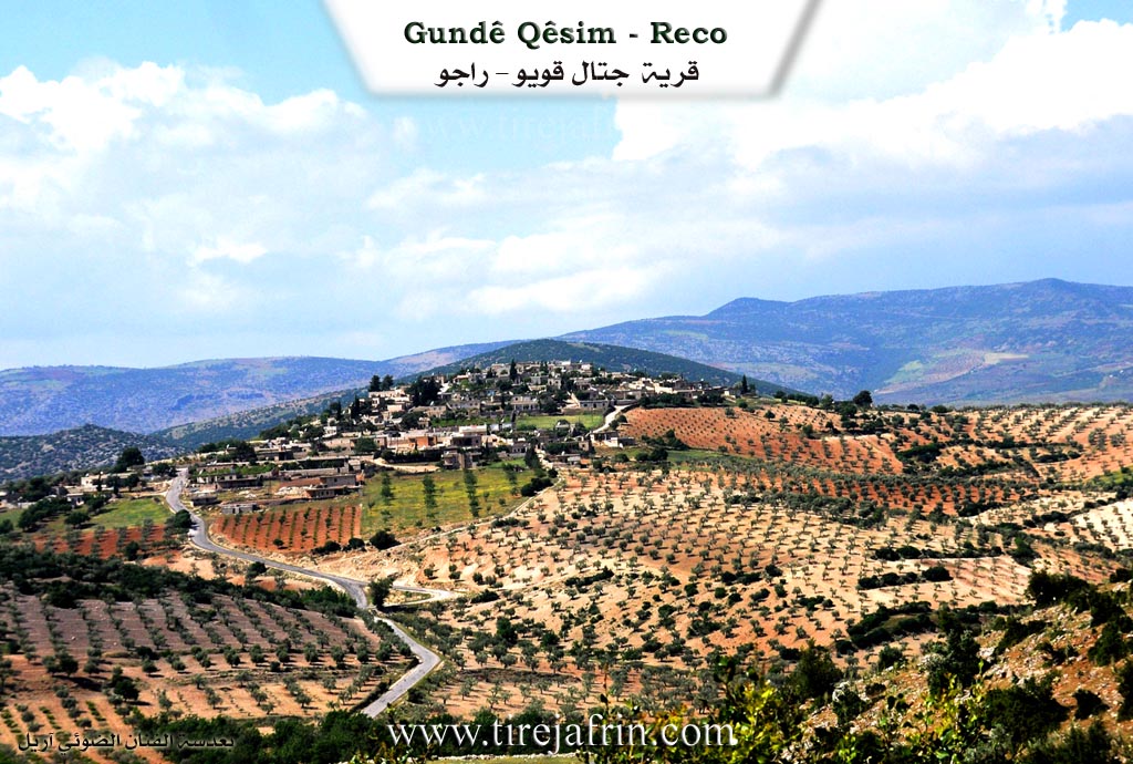
Gundê Qasim Çetel Qûyû El-Biêrên
According to the book Çiyayê Kurmênc (Efrîn): A Geographical Study: Gundê Qasim, Çetel Qûyû, El-Biêrên / 1720 inhabitants - 332 hectares - 8 km - 778 m /:
The popular name is derived from the personal name "Qasim." As for the Turkish name Çetel Qûyû, it means "possessor of two wells" due to the presence of two old wells beside the village. The Arabized name is a translation of the Turkish designation. Before the adoption of the final Arabized name, the name had been Arabized to "Şeta El-Quwe," but this was later discarded.
It is a medium-sized village located on the highest peak of a limestone plateau. It is one of the villages of the Dîko clan, and most of their families reside there.
According to the book Efrîn... Her River and Her Green Hills: Çetel Qûyû is a village in Çiyayê Kurmênc that belongs to the Reco district, Efrîn region, Heleb governorate. It is a large village located on a wide, undulating summit of a furrowed limestone plateau, overlooking its agricultural and alluvial lands. It is located 8 km northeast of the town of Reco. It is bordered to the north by a slope, a plain, the Riya Bilbil-Kûtanlî-Reco (Bilbil-Kûtanlî-Reco road), and the village of Zerkanlî; to the south by a valley, a plain, and the village of Şêxler Obasî on a high elevation; to the east by a slope, a valley, and the village of Dîk Obasî; and to the west by a harsh slope, a deep watercourse, and the village of Kûranlî.
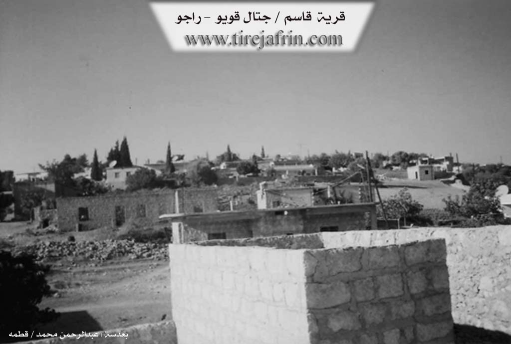
The number of houses reaches about 80, and the age of the village is approximately 400 years. It was built on the ruins of the old village. Its dwellings were originally stone and mud with wooden roofs, but it has expanded with modern cement construction on all sides. An electricity network and a primary school are available. The village drinks from rainwater collected in household cisterns or from very old wells dating back to the Roman era. Note that there are three old wells in the village (two of them on the eastern side of the village and the other at the bottom of a valley on the southern side). Large, ancient, perennial trees circle the site of the wells. This village was named El-Biêrên (The Two Wells) in reference to the wells found within it.
It connects to the main road via an unpaved dirt road. The residents work in rain-fed agriculture (olives, grains, vines, walnuts, almonds, apples, cherries) on an area of 332 hectares, alongside raising sheep and goats. The village is considered one of the beautiful villages in terms of the beauty of both modern and ancient construction and the abundance of trees surrounding the village, which distinguishes it as if the village lies within a garden.
Among its most important families are: (Sîdo Dîko), who were the first to inhabit the village.
Among the holders of higher degrees in the village: Ismaîl Ehmed / PhD in Engineering / Dams Department / Russia.
Mukhtar of the village: Izet Bilal Mihemed.
Sources of Information:
- Book: جبل الكرد (عفرين) دراسة جغرافية Çiyayê Kurmênc (Efrîn): A Geographical Study by د. محمد عبدو علي Dr. Mihemed Ebdo Elî.
- Book: عفرين .... نهرها وروابيها الخضراء Efrîn... Her River and Her Green Hills by عبدالرحمن محمد Ebdulrehman Mihemed from the village of Qetme.
- Studies of Navenda Tirej Soft / Ebdulrehman Hacî Osman.
- Some residents of the villages.
Preparation and Execution: Manager of the Tirej Efrîn website: Ebdulrehman Hacî Osman 20/12/2013
II. Summary of Qêsim from Ax û Welat
Source: https://www.youtube.com/watch?v=1wodNxVx83E
The village of Qesim, located in the Reco district of the Efrîn region, sits situated between Çiyayê Hawarê and Çiyayê Bilêl. Before it acquired its current name, the location was known as Gaza Hêro. The village was renamed Qesim after the founding ancestor of the first family settled there more than 300 years ago. Historically, the village is inhabited by members of the Omka tribe (also referred to as Amka). The settlement was originally established by five core families: Qesim, Dîkê, Îso, Molekuzê, and Osmanîçep. Over time, other lineages such as Ehûka and Evdike have been noted, though the entire village is bound by the kinship of the Omka tribe.
The village is renowned for the leadership of Seydayê Dikê (also known as Seyda Axa), a prominent historical figure and leader of the Omka tribe. Seydayê Dikê was responsible for approximately sixty villages in the region, including the Amkan Jorin (Upper Amkan) and villages in the plains like Senarê, Anqelê, and Tirmûşa. He is celebrated for his resistance against the French Mandate forces in the 1930s. Residents recount that Seydayê Dikê, alongside allies such as Ehmedê Rût, Adê Îmir, and Mela Şûrbe, organized attacks against French interests. Notable engagements include an ambush at Geliyê Tîra, where resistance fighters overturned a French military train, and a battle at Çerxereya Badîna. While the French eventually entered Qesim and threatened to burn it, negotiations led to their withdrawal, though the village was subsequently bombarded by aircraft.
Daily life in Qesim has long revolved around agriculture and access to specific water sources. Before modern infrastructure, the villagers relied on ancient wells, many of which are still named and remembered, including Bîra Derê, Bîra Dûnxiz, Bîra Gelê, Bîra Ker, and Bîra Qestel. Several springs also define the local geography, such as Kaniya Kurê and Avên Kewa.
Culturally, the village maintains specific traditions. Cemal, a craftsman from the Evdike family, is known for constructing musical instruments, specifically the tembûr, using wood from local tû (mulberry) trees. The village also preserves culinary heritage, with elders preparing traditional dishes like tirşika kundiro (pumpkin stew), bişbiş, and qatmer. Additionally, Qesim has a reputation for keeping gamecocks (dîkê şer), a tradition passed down from elders like Hebeş Axa, with residents like Omerê Reşîd and Dîko Berdenhev continuing to raise these birds, originally of the Gêlanî breed.
II. Summary of Qêsim from Afrin Flo
Source: https://www.youtube.com/watch?v=FOM9gjDGnAk
The village of Qestem which is also referred to as Qestel or Qêsim in the Afrin region of Kurdax. According to the elders the village was founded approximately 350 to 400 years ago. The history of the settlement is intrinsically linked to the Dîko family. A prominent resident named Henan Hebeş Henan Dîko explains that the community identifies strongly as Qosimlera. This group originated when the Dîko family gave a wife to their nephew named Qosim establishing a bond that united the families. While the Dîko family remains central including sub branches like Mala Henanê Dîko and Mala Seydê Dîkê other families have also been part of the village history. The Mala Kûze family arrived later from the village of Dîko while the Mala Îsa and Mala 'Elê families once lived there but have since moved away.
The social structure is rooted in these long standing family lines and the village is noted for its high level of education with many residents becoming doctors and engineers. The residents also preserve the memory of Seyda Axa or Seydo Axa who was a leader of the Omko tribe and an ancestor of the current inhabitants. The village house visited in the footage dates back to 1321 Hijri which corresponds to 1902 AD and contains historical artifacts such as a bell called Çan brought from Kilis over 150 years ago and a stone mortar known as Bîmolk.
Geographically Qestem is situated in a mountainous area described as being without natural stones in the immediate village soil which is dominated by Merx trees. However it is surrounded by prominent elevations including Çiyayê Hawar and Çiyayê Bilêl as well as Çiyayê Cirqa and Kêlşîr and Kurê. The village overlooks the Deşta Meydanê near the location of Ziving. Water sources serve as critical landmarks in this landscape. The speakers list several specific wells including Bîr Donguz located to the east and Bîrkar which was originally a spring where a young goat died. Another notable well is Bîrê Du Dara which features two openings resembling a spring source. A more recent well named Biziya was dug by hand by Hesen Agha about 60 to 70 years ago. A valley in the area retains the name Geliyê 'Elê named after the family that formerly resided there.
II. Summary of Qêsim from Afrin 366
Source: https://www.youtube.com/watch?v=cW2p-lCUumo
The documentary focuses on the village of Qesim, located in the Reco area of the Afrin region. According to local elders, the village has a history spanning approximately 200 to 300 years. Its name is derived from the Mala Qesim, the family lineage considered to be the founders or the most prominent group in the settlement. While the village currently hosts about 120 households, residents note that Arab populations who once lived there have since departed, leaving the current population largely homogenous.
The geography and history of Qesim are deeply defined by its water sources. In the past, the village relied on six or seven specific wells located some distance away. Elders recall these landmarks vividly, specifically naming Bîra Romanî, Bîra zêr, and Bîra kevin. Another significant site mentioned is Bîrker, a well located further down from the village. This site was formerly marked by a massive tree, estimated to be 250 years old, which was unfortunately destroyed by fire. The landscape offers views of surrounding areas, including Zahrê Bilbilê and neighboring villages such as Dîkê, Aşûnê, Zivingê, and Çê.
Socially, the village structure revolves around several key families. Alongside the founding Mala Qesim, the residents mention Mala Dîkê, Mala Hûko, and Mala Îsê. The documentary highlights the hospitality of local elders like Apê Aras and Ehmed, who maintain well tended courtyards filled with plants like Iklîl Cebel. The community maintains strong emotional ties to relatives living in the diaspora, with specific greetings sent to family members currently residing in Elmanya and Holanda. Despite the scenic nature of the village and its historic stone architecture, residents note a lack of certain modern infrastructure, such as a central water network, relying instead on traditional wells and cisterns.
Transcriptions and Subtitles
| Source | Video | Subtitles | Transcript |
|---|---|---|---|
| Afrin 366 1 | Watch Video | Download SRT | View Transcript |
| Afrin Flo 1 | Watch Video | Download SRT | View Transcript |
| Ax û Welat 1 | Watch Video | Download SRT | View Transcript |
Foundation/Origin Information of Qêsim
It is one of the Âl Diku villages. The Sido Diku family were the first to inhabit the village.
Source: TirejAfrin Site
Originally founded by the Elî and Gewanê families. The Dîko family, part of the Amka tribe, migrated to the area from a village called Dîkê.
Source: Afrin Flo Transcript
Possible Village Name Meaning of Qêsim
The popular name comes from the scholar 'Qasim'. The Turkish name Çetel Qoyou means 'with wells'. The Arabic name Al-Ba'rain is a translation of the Turkish. It was also briefly Arabized to 'Sheta al-Quwwa'.
Source: TirejAfrin Site
V. Links
- Tirej Afrin:
https://www.tirejafrin.com/site/kura%20afrin%20%20%20Reco%20-%20Qesim.htm - Ax û Welat:
https://www.youtube.com/watch?v=1wodNxVx83E - Videos:
https://www.youtube.com/watch?v=AkCdPUYpIuE - Link:
https://www.youtube.com/watch?v=WpF_kYIXozU - Afrin Flo:
https://www.youtube.com/watch?v=FOM9gjDGnAk - Afrin 366:
https://www.youtube.com/watch?v=cW2p-lCUumo