General Information
Nahiya (Subdistrict)
Reco
Also Known As
Gundê Qopê / Hamshalk / Qopê / Qûbê / Ĥemşelek / حمشلك / حمشو / Ḧemşelek, قوبه
Tribes
Bîyan, Neîm
Families, Clans, etc.
Ebdî Mehoko, Ehson Lero, Elî Balo, Elî Palo, Ezeddîn Hemra, Heboke, Hebîb, Hecîba, Hecîko, Hecîkê Şîmo, Hemşelek, Hesenê Emşê, Heyder, M'hemedê Henî, Mala Bekir, Mala Evdoyê Elî Sêlim, Mala Hisênê Elî, Mala Ĥebba, Mehmûd, Mirad, Mislim, Mislim Lero, Miştê Hese, Omer, Qobe, Sebrî Yûsif, Xelefê Derê, Xelîlê Ehmed, Şemdînê Ebdê, Şêxo, Şêxê Elîkê

Photos
Basic Information about Qopê
Source: Afrin Flo
Etymology: Named after a wealthy man named Hemo who stored meat in large jars (qûp) for guests, leading to the name Qûpê (from 'Qûpê di goşt'). Also called Hemşelek or Hemşû, referring to Hemo dragging supplies or guests.
Foundation Date/Period: Approximately 300 years ago
Caves: Şikefta mezin, Hecîko
Hills: Ber çoyê gewir
Shrines: Sifî Pênc
Ruins: Gundê Elî Bolo, Gundê Xelek
Wells: Bîra Pilingê, Bîra Elî Teybê, Bîra Sînê, Bîra dîşko
Other Landmarks: Çiyayê Hawar, Deştî bolo, Destê nodan, Kutx, Binê dehrikî
Source: Afrin 366
Springs: Kaniya Lîme
Wells: Sarincê Kapnor
Summaries
I. Summary from TirejAfrin Site (English) of Qopê
Source: https://www.tirejafrin.com/site/kura%20afrin%20%20%20Reco%20-Qopa.htm
It is stated in the book جبل الكرد (عفرين) دراسة جغرافية Çiyayê Kurmênc (Efrîn): A Geographical Study: Ĥemşelek - Gund Qop Ziving / 1627N - 10km - 550m /:
The village is called by three names. The first is Ĥemşelek, which is composed of two words: "Ĥem," a proper noun derived from Mihemed, and "Şelek," meaning "load of straw/wood," which is also used as an adjective for a large-bodied person. The second is Qop, meaning "boiled piece of meat"; it is said that the owner of the village was generous, slaughtering animals and inviting people to eat, so the village was named "morsel of meat" (Qop). The third is Ziving, meaning "cave" in Kurdish. It is the name of a small village that existed above the current village; its inhabitants abandoned it, descended to the slopes, and established the new village.
Ĥemşelek was formed from three ancient residential clusters that were adjacent to each other near the mountain peak. These villages were: Elî Palo, Geliyê Zivingê, and Mala Ĥebba. Their inhabitants abandoned them in the second quarter of the twentieth century due to the ruggedness of their locations and the difficulty of reaching them, and most of them settled in the village of Qop.
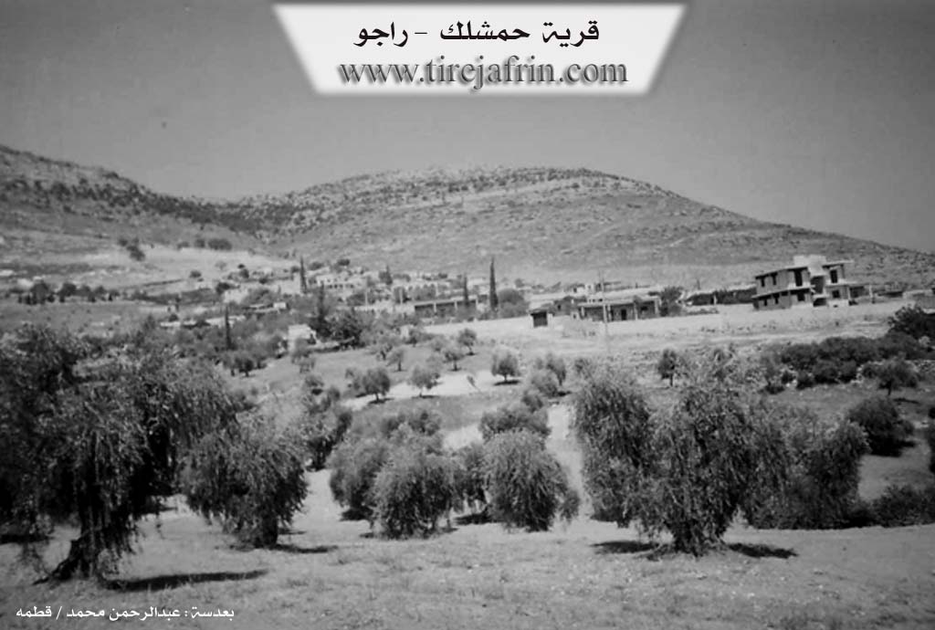
It is a small village located on the southern slope of Çiyayê Benê, and on the western side of the southern entrance to the Geliyê Tîra valley. It overlooks the plain of Beçdinê, which is covered with olive trees.
It is stated in the book عفرين .... نهرها وروابيها الخضراء Efrîn... Her River and Her Green Hills: Ĥemşelek is a village in Çiyayê Kurmênc belonging to the Reco district, Efrîn region, Heleb governorate. It is a large village located on the eastern slope of Çiyayê Beleng in the western section of the northern part of the Çiyayê Kurmênc massif. It overlooks agricultural land towards the south and east and is surrounded by a number of watercourses. It lies southeast of the town of Reco at a distance of 9 km.
It is bordered to the north by a rugged mountain range, the village of Derwîş Obasî, and the village of Mosik Obasî. To the south, it is bordered by the fertile agricultural Deşta Kitix (Kitix plain) and the village of Ereb Uşaxî. To the east, it is bordered by a slope, the Xeta Trêna Heleb-Meydan Ekbez (Heleb-Meydan Ekbez railway line), the Riya Reco-Efrîn (Reco-Efrîn road), the Geliyê Tîra valley, and the village of Berbend. To the west, at a distance of 500 m, lies the village of Beçdinê.
The number of its houses is about 100, and its age is approximately 300 years. Its houses are made of stone and mud with flat wooden roofs, while the modern ones are made of cement and have started to spread towards the south and west. An electricity network and a primary school are available. There are two asphalt roads: one connects the village of Beçdinê and Ĥemşelek, and the other connects to the district and the region. The village drinks from a network that draws its water from the Beçdinê well, and there is a mosque in the center of the village. The residents work in rain-fed agriculture on an area of 500 hectares (olives, grains, legumes) and irrigated agriculture from artesian wells for summer vegetables. They also raise sheep and goats.
Village Mukhtar: Ednan Ĥemo Arif
Sources of Information:
- Book: جبل الكرد (عفرين) دراسة جغرافية Çiyayê Kurmênc (Efrîn): A Geographical Study by د. محمد عبدو علي Dr. Mihemed Ebdo Elî.
- Book: عفرين .... نهرها وروابيها الخضراء Efrîn... Her River and Her Green Hills by عبدالرحمن محمد Ebdulrehman Mihemed from the village of Qetme.
- Studies of Navenda Tirej Soft / Ebdulrehman Hacî Osman.
- Some residents of the villages.
Preparation and Execution: Director of the Tirej Efrîn site: Ebdulrehman Hacî Osman 20/12/2013
II. Summary of Qopê from Afrin Flo
Source: https://www.youtube.com/watch?v=AXZp_NUrJWY
The village of Qûpê, also known historically as Hemşelek, is situated in the Efrîn region near Çiyayê Hawar. According to local oral history, the village was founded approximately three hundred years ago. Its name implies a history of hospitality and abundance; elders recount that a wealthy ancestor named Hemo kept large storage jars (called qûp) filled with preserved meat to feed guests and travelers. People would say they were going to "Hemo of the meat jars" (Hemo qûpê di goşt), which evolved into the name Qûpê. The alternate name, Hemşelek, is said to derive from Hemo dragging (şelek) provisions.
The settlement history of Qûpê is complex, involving the consolidation of earlier sites. Residents explain that the village formed from the merger of three distinct entities or nearby hamlets: Elî Bolo, Hecîba (or Hecîko), and Hemşelek. Remnants of these older sites, such as the ruins of Gundê Elî Bolo, are located near the current village. In the past, the inhabitants lived primarily in caves, including a site known as Şikefta mezin, before moving into stone and earth houses which have since largely collapsed or been replaced.
The village is home to a significant religious site, the shrine of Sifî Pênc, described as a "large tomb." A foundation legend connects this site to the arrival of storks and the discovery of water near Gundê Xelek, which prompted people to settle there. Historically, the villagers relied on communal wells for water, specifically named landmarks such as Bîra Pilingê, Bîra Elî Teybê, Bîra Sînê, and Bîra dîşko, before the advent of modern cisterns.
Socially, the village comprises various distinct families, including Mala Heyder, Mala Ebdî Mehoko, Mala Sebrî Yûsif, and Mala Ehson Lero. The elders, such as Mehdîn Mislim and Ebdo Elî Yûsif, recall a time of deep communal solidarity, where meat from sacrifices and agricultural harvest was shared widely among neighbors. Economically, the village has transitioned from vineyard cultivation (Rez) and grain farming to being dominated by olive groves (Zeytûn). Education was historically difficult, with children walking to Baedîna until a local school was built in Qûpê around 1976 during the era of Hafez El Esed.
II. Summary of Qopê from Afrin 366
Source: https://www.youtube.com/watch?v=VCX3oFY4sBc
The documentary focuses on the village of Qûpê, located in the Çiyayê Kurmênc region. The village is described by the host as a small but ancient settlement (kevnar) situated on high ground. The landscape is characterized by rugged terrain, numerous caves (şikeft), and ancient cisterns (sarinc) carved into the rock. One specific water source or cistern area is identified as Kaniya Lîme, while another significant subterranean site is referred to as Sarincê Kapnor. The village also contains ancient olive trees that were once sold cheaply due to debt but are now considered extremely valuable.
The history of land ownership in Qûpê is detailed through the testimony of an eighty year old elder, the son of Hisênê Elî. He explains that in the era of his forefathers, land ownership was determined by zote (force or occupation) rather than legal documentation. This changed in 1964 with the arrival of the Islah Zira'î (Agrarian Reform) implemented by the Syrian state. During this period, the local Axa (feudal lords) fled the region, and the land was subsequently distributed among the villagers, who then registered the deeds in their own names. The elder recalls a time when daily life was difficult but social bonds were stronger; he laments that while technology has arrived, the "taste of humanity" has vanished, and familial strife has increased.
Socially, the village is comprised of tight knit families, though many residents have emigrated. An elderly woman interviewed in the village mentions she originally hails from Gundê Dêrîş and identifies a nearby home as belonging to Mala Evdoyê Elî Sêlim. The host also visits his cousin Bekir and highlights a local shop run by Babekir, which has been serving the community for approximately forty five years. The village architecture features old stone houses and communal spaces where residents once ground wheat (genim dihêran) and baked bread, reflecting a historically self sufficient lifestyle that has largely faded in the modern era.
II. Summary of Qopê from Multi Channel
The documentary explores the village of Hemşelek, located twenty one kilometers northwest of Efrîn. Geographically bounded by Raco, Ma'betlî, Birbend, and Ba'denlî, the modern village is approximately three hundred years old. However, the surrounding area has roots stretching back to the Roman and Byzantine periods. The original inhabitants lived in an older village higher up the mountain but relocated to the current lower site during the second quarter of the twentieth century due to rugged terrain and difficult access. According to local elders, Hemşelek was historically composed of three distinct but adjacent settlements near the mountain peak.
The village is primarily inhabited by Kurdish families belonging to the Bîyan tribe and Arab families from the Neîm tribe. A fascinating aspect of the social fabric is the deep integration of these groups. The Hebîb family, descending from the Neîm tribe ancestor Ezeddîn Hemra, settled in the area over two hundred years ago. Over time, this Arab family fully integrated with the local Kurdish population. They lived alongside the original Kurdish families, intermarried, and adopted the Kurdish language. Older residents of all backgrounds now predominantly speak Kurdish, with some elders speaking very little Arabic. Other notable families include the Hemşelek, Elî Balo, Şêxo, Mislim, and Mirad lineages. Historically, members of these families spread out to nearby areas like Ereb Uşaxî, Zefenke, and Ba'denlî.
The village name Hemşelek is said to mean straw, while the name of the lower settlement and clan, Qobe, translates to meat. The landscape is marked by historical remnants, such as the ancient caves locally known as Ziqnaq, which were used by early settlers who sought refuge in the mountains. Surrounding the village are notable geographic features like Çiyayê Hebîb and Çiyayê Kolo, along with the old housing foundations of the Elî Balo settlement. The area also contains ancient cisterns and wells dating back centuries.
Today, Hemşelek is known for its agricultural character, particularly the cultivation of Zeytî and Xelxalî olives, almonds, and sumac. Despite its small size, it hosts displaced people from Heleb, Kifr Emîm in Îdlib, and Baba 'Emero in Hims. The village accommodates an industrial workshop run by a displaced man from Heleb. Since 2014, this workshop has built commercial baking ovens for bread and kaak, providing jobs for local residents and supplying businesses across northern Syria. The documentary concludes with a display of traditional music, featuring local musicians playing the buzuq and explaining how Kurdish musical traditions are deeply inspired by the natural sounds of the mountain environment.
Transcriptions and Subtitles
| Source | Video | Subtitles | Transcript |
|---|---|---|---|
| Afrin 366 1 | Watch Video | Download SRT | View Transcript |
| Afrin Flo 1 | Watch Video | Download SRT | View Transcript |
| Multi Channel 1 | Watch Video | Download SRT | View Transcript |
Foundation/Origin Information of Qopê
'Hamshalk' was formed from three old residential clusters (Ali Palo, Wadi Zivng, and Beit Habib) whose inhabitants migrated in the second quarter of the 20th century and settled in Qopê village.
Source: TirejAfrin Site
Possible Village Name Meaning of Qopê
Called by three names. Ḧemşelek: from 'Ḧem' (Mohammad) and 'Şelek' (wood carrier). Qop: 'piece of boiled meat,' as the village owner was generous. Zîvîng: 'cave' in Kurdish, the name of a small village that existed above the current one.
Source: TirejAfrin Site
V. Links
- Tirej Afrin:
https://www.tirejafrin.com/site/kura%20afrin%20%20%20Reco%20-Qopa.htm - Jawlat:
https://www.youtube.com/watch?v=Dqw3_kUg-ZI - Local FB page:
https://www.facebook.com/Hamshalak - Video:
https://www.youtube.com/watch?v=fRaRvQyv3UE - Afrin Flo:
https://www.youtube.com/watch?v=AXZp_NUrJWY - Afrin 366:
https://www.youtube.com/watch?v=VCX3oFY4sBc