General Information
Nahiya (Subdistrict)
Reco
Also Known As
Al-Murtafa'a, Murtfa'a, Qada, Qedê, Qude, المرتفعة, قوده كوي, قداه
Tribes
Şêxa
Families, Clans, etc.
Elî Bili, Ereb, Fato, Gurfa, Haco, Hec Mûsa, Hecî Hecûm, Henan, Hevşo, Heyder, Kirmû, Mala Ebû Faiq, Mala Sebrî, Mala Sebrî Mûsa, Miso, Mist Kêle, Nano, Qudê, Siyamendo

Photos
Basic Information about Qude
Source: Ax û Welat
Etymology: Named after the founder Qudê who was a wealthy nobleman from the Şêxa tribe
Foundation Date/Period: Approximately 400 years ago
Springs: Kaniya Kûkila
Trees: Merx
Wells: Bîra Hejîrkê, Bîra Kûkila
Source: Afrin 366
Hills: Çiyayê Gewr, Bûzî Kûl
Ruins: Meqbeza Hecer
Trees: Darê Hacîka
Wells: Bîra Hacîka
Other Landmarks: Benê Ne'meto, Deşta Sûrke, Kalmon
Source: Khalil Sino
Foundation Date/Period: 400 to 500 years ago
Summaries
I. Summary from TirejAfrin Site (English) of Qude
Source: https://www.tirejafrin.com/site/kura%20afrin%20%20%20Reco%20-%20Qude.htm
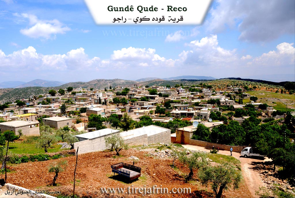
It is stated in the book جبل الكرد (عفرين) دراسة جغرافية Çiyayê Kurmênc (Efrîn): A Geographical Study: Gund Qude, Qude Koy, "The High". Population: 1794. Houses: 373. Distance: 7km. Altitude: 920m.
Qude: In Kurdish, it means "the high/tall stature." This was the nickname of the first inhabitant of the village. His origin was from the village of Eqîlme, and most of the village residents descend from him.
It is a small village located on the peak of a mountainous elevation with steep slopes on its four sides. Its beautiful location, surrounded by natural forests and facing Çiyayê Amanos to the west, is suitable for establishing wonderful summer resorts.
It is stated in the book عفرين .... نهرها وروابيها الخضراء Efrîn... Her River and Her Green Hills: Qude Koy: A village in Çiyayê Kurmênc following the district of Reco, Efrîn area, Heleb governorate. It is a large village located on the middle slope of the mentioned mountain. It is bordered to the north by a harsh slope, a deep valley, a mountain range after the valley, the village of Hesen Kelkewî, and the village of Hecîk. To the south, it is bordered by a deep valley, a rugged mountain range, and the village of Memala. To the west, a high mountain range and the village of Omera. To the east, a rugged mountain range, several watercourses, and the village of Dêrwîş Oba.
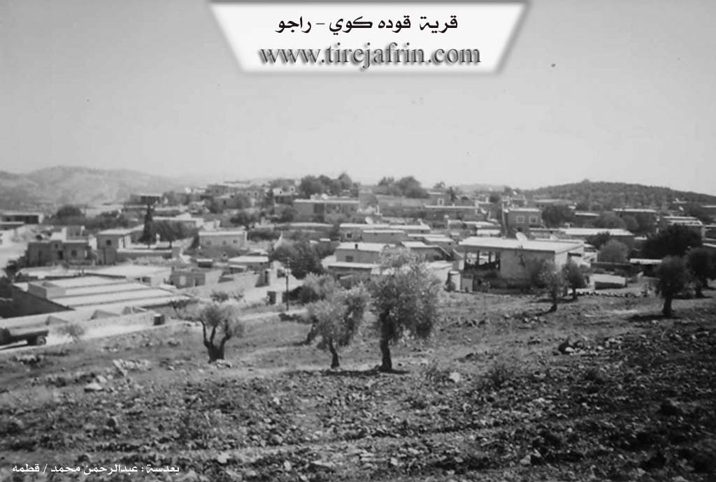
The number of its houses reaches about 200, and its age is about 500 years according to the account of one of the elderly people in the village. Its houses are stone and mud with flat wooden roofs, while modern cement ones have spread east and west. An electricity network is available, and the residents drink rainwater stored in pools or cisterns dug into the houses. The village has a primary and preparatory school, and a mosque in the center of the village.
The residents work in rain-fed agriculture (olives, vines, legumes, grains) and some fruit trees, alongside raising sheep and goats due to the mountainous nature surrounding the village from all sides. The village connects to the district and neighboring villages via newly asphalted roads reaching the center of the village. The village is considered one of the old villages in the Efrîn region.
Among the families of the village are: the Hec Mûsa family (branches: Bekir/Bakîr, Osman (Memo), Silêman, Mihemed); the Mist Kêle family (Mûsa); and the Haco family. It is mentioned that Dr. Iqbal Xelîl Ereb, who holds a PhD in Informatics from France, and (Dr. Fethî Osman, Şukrî Osman, Ebdulezîz Bakîr), who hold higher degrees in their medical specializations, are children of this village, in addition to the presence of many university degree holders.
Village Mokhtar: Ehmed Silêman Omer.
Sources of Information:
- Book: جبل الكرد (عفرين) دراسة جغرافية Çiyayê Kurmênc (Efrîn): A Geographical Study by د. محمد عبدو علي Dr. Mihemed Ebdo Elî.
- Book: عفرين .... نهرها وروابيها الخضراء Efrîn... Her River and Her Green Hills by عبدالرحمن محمد Ebdulrehman Mihemed from the village of Qetme.
- Studies of Navenda Tirej Soft / Ebdulrehman Hacî Osman.
- Some residents of the villages.
Preparation and execution: Manager of the website Tirej Efrîn: Ebdulrehman Hacî Osman 20/12/2013
II. Summary of Qude from Ax û Welat
Source: https://www.youtube.com/watch?v=T7mENt26n8Y
The village of Qudê, located in the Afrin region (specifically linked to the Reco district), is a settlement with a history spanning approximately four centuries. According to village elders like Apê Mihemed, the village was founded by an individual named Qudê, a wealthy and noble man ("xanedan") from the Şêxa tribe. The founder arrived in this specific location after conflicts arose in other Kurdish territories, seeking a place with sufficient pasture and water for his livestock. While the village has always been known as Qudê to its inhabitants, the state authorities attempted to Arabize the name to El Murtefe'a, meaning "The High One," referencing the village's high elevation.
The social fabric of Qudê is composed of several distinct families. Apart from the lineage of the founder Qudê, the village is home to the families of Miso, Henan, Nano, Elî Bili, Siyamendo, Fato, and Ereb. Apê Mihemed notes that not all current residents are direct descendants of the founder; specifically, five of these families originated elsewhere before settling in the village.
Water scarcity and management played a significant role in the village's history. The community relies on historical water sources such as Kaniya Kûkila (also referred to as Bîra Kûkila) and Bîra Hejîrkê, the latter located approximately two kilometers away. These water sources were vital not only for Qudê but were also used by the neighboring village of Dêrîş, and occasionally led to conflicts with the village of Hesen over access. In the past, water had to be laboriously transported by back or draft animal from these distant points.
A central feature of the village's cultural landscape is a massive, ancient tree known as the Merx. Estimated to be over two hundred years old, this tree serves as a communal gathering spot. It functions as a natural sanctuary where villagers of all ages, from elders like Apê Elî to children, gather during holidays and celebrations to rest in its shade, swing on ropes, and maintain social bonds.
The village preserves many traditional aspects of rural Kurdish life. Elders describe the use of the Cercer, a traditional threshing sled used on the threshing floors ("bêder") for months at a time during the harvest season. Residents also maintain culinary traditions, preparing specific dishes such as Sermîsok, Lûrk, and a sweet made from grape molasses called Vişvişk or Zengilûk. The community is also known for preserving ancient games like Tûş, played by women and children in the pastures, and for their localized craftsmanship, such as farriery work traditionally learned in Heleb and practiced in Reco.
II. Summary of Qude from Afrin 366
Source: https://www.youtube.com/watch?v=WTN5wE60Cuc
Gundê Qudê, also referred to simply as Qudê or Qada, is a high-altitude village located in the Raco district of the Afrin region. The village is characterized by its elevation and rugged terrain, offering expansive views of the surrounding geography, including Çiyayê Gewr and the Deşta Sûrke. It borders the villages of Dêwirîş (also called Gundê Dêwirîş), Hecîko, and Hesen.
The social structure of Gundê Qudê is comprised of several distinct lineages. The current population is estimated between 200 and 275 households. One resident notes that the community includes a mix of people, stating "Ereb nav man da ne" (Arabs are among us), while identifying his own group as Hevşo (or Hevş). Prominent families mentioned include Mala Sebrî, Mala Sebrî Mûsa, and Mala Ebû Faiq. The Hecî Hecûm family is particularly notable for their economic role in the village; Evdînê Hecî Hecûm, also known as Ebû Receb, is identified as the former mukhtar and owner of the local olive press. Other mentioned residents include Seîdê Kirmû and Mistefa Gurfa (also referred to as Kado Gurfa).
The village entrance is marked by a significant landmark pairing: Bîra Hacîka (The Well of Hacîka) and the adjacent Darê Hacîka (The Tree of Hacîka). This site serves as a gathering point, though speakers note that many trees in the area have been cut down. Another specific location within the village territory is Benê Ne'meto, a high point described as a sirt (ridge), and Bûzî Kûl, a hill or mound that overlooks the village boundaries.
Economy and daily life in Gundê Qudê revolve heavily around olive cultivation. The village contains a modern olive press built in 1985, managed by the Hecî Hecûm family. There are also ruins of an older stone press, referred to as Meqbeza Hecer, which is now dilapidated (xarabî). The documentary highlights the practice of afarê, gleaning leftover olives after the main harvest, as a traditional activity, particularly for children.
Culturally, the village is home to Gîvara Heyder, a dengbêj (singer) who performs songs celebrating the region's geography, mentioning places like Çiyayê Hawarê, Cindêrêsê, and Geliyê Tîra. The village also possesses a school (Mekteb) but lacks a bakery, relying on Raco for bread. The residents describe the village as having a "popular" (şe'bî) and lively atmosphere during the olive harvest season.
II. Summary of Qude from Khalil Sino
Source: https://www.youtube.com/watch?v=q4EYBjDzcRI
The village of Qudê, also referred to as Murtefa in Arabic and occasionally pronounced as Qederê by the host, is situated in the Raco district of the Efrîn region. It is located approximately 7 to 8 kilometers from the center of Raco. The village sits at a high altitude, estimated by residents to be between 1000 and 1200 meters, offering expansive views that reach as far as Lîwa Skenderûn and Heleb. According to an elder named Sewle, the village was founded on this mountain peak approximately 400 to 500 years ago. A resident named Hemîd suggests the name Qudê is derived from the history of their ancestors first settling or "sitting" in that specific spot.
The social structure of Qudê is comprised of approximately 300 households. The documentary highlights the return of residents from the diaspora; specifically, Hemîd returned to his ancestral home after living in Stenbol for 22 years. Hemîd belongs to a family of traditional bone-setters (mucebir) who have practiced this healing art for over a century, inheriting the skill from their fathers and grandfathers. He expressed that the clean air of Qudê cured the breathing difficulties he suffered in the city. Other residents interviewed include Zuwêr Ebdilmihemed, Mihyedîn Reşîd, and his wife Sewle, as well as Zeyneb, a mother of eight.
Historically, the agricultural identity of Qudê was defined by a specific type of pear known locally as qeşermît or hirmê, which grew abundantly in the vineyards. However, these trees have largely disappeared, replaced by orchards of cherries (keras), apricots (mişmiş), almonds (be'îv), and olives (zeytûn). The residents maintain a strong connection to their past; Zeyneb recalled a time when life was materially harder but socially richer, characterized by safety and communal activities like fetching water from the springs and children playing late into the night.
The village preserves specific culinary traditions, such as the preparation of Zangelûk. Zeyneb described this dish as a sweet made from water, flour, and grape molasses (dims), which is fried in oil and garnished with sesame seeds (kunc). This traditional treat is also known by the names Qilqê Pîra or Qilqê Kalo. Despite the challenges of modern life and migration, the residents express a deep devotion to their land, viewing their return to Qudê as a restoration of their health and spirit.
Transcriptions and Subtitles
| Source | Video | Subtitles | Transcript |
|---|---|---|---|
| Afrin 366 1 | Watch Video | Download SRT | View Transcript |
| Ax û Welat 1 | Watch Video | Download SRT | View Transcript |
| Khalil Sino 1 | Watch Video | Download SRT | View Transcript |
Foundation/Origin Information of Qude
Most of the village's inhabitants descend from the first inhabitant.
Source: TirejAfrin Site
Founded by people who migrated from Xelîlê Qirnîkî and other nearby villages. The community was established by nine core families, five of whom are considered original.
Source: Ax û Walat Transcript
The village was founded by the family of a 'qazî' (judge).
Source: Halil Sino Transcript
Founded by ancestors from the Shikakan (Şikakan) tribe who migrated from the Botan region.
Source: Afrin Flo Transcript
Possible Village Name Meaning of Qude
Qude in Kurdish means 'the high elevated stature', and it is the title of the first inhabitant of the village, who was originally from Çeqilme village.
Source: TirejAfrin Site
Its original Kurmanji name is Qudayî. Due to its high elevation, it was officially named 'El-Murtefea' by Syrian Arab authorities and also called 'Gawrî' by Turkish and Arab officials.
Source: Ax û Walat Transcript
Known in Arabic as Murtfa'a due to its high elevation. It derives its name from a 'qazî' (judge).
Source: Halil Sino Transcript
Its original Kurdish name is Qedê, but it was later renamed 'Qastal' by the Syrian regime.
Source: Afrin Flo Transcript