General Information
Nahiya (Subdistrict)
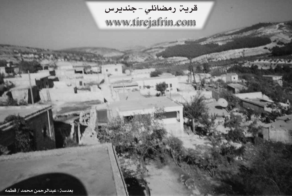
Cindires
Also Known As
Ramadan, Ramadanê, Remedana, Remedano, Remedena, رمضانلي, رمضانه
Families, Clans, etc.
Dawûdî, Hevîdî, Mala Hemedî Ne'sê, Mala Kemo, Mala Mûsê, Mala Simo, Mala Şîşo, Muserdî, Nesredî

Photos
Basic Information about Remedena
Source: Ax û Welat
Etymology: Named after Remadan or Eliyê Remedên, the first ancestor who settled the village
Springs: Kaniya Ûzê, Kaniya Kêlê Ehmed, Ava Qimete
Hills: Çiyayê Xastiya, Çaka, Zinarê Zîn
Ruins: Dimilî, Aş
Trees: Merx
Wells: Sarînca Xerbî
Other Landmarks: Geliyê Cercemê, Geliyê Hûre, Geliyê Qîmetê, Geliyê Dole, Gola Êş
Summaries
I. Summary from TirejAfrin Site (English) of Remedena
Source: https://www.tirejafrin.com/site/kura%20afrin%20Cindires%20-%20remedena.htm
According to the book جبل الكرد (عفرين) دراسة جغرافية Çiyayê Kurmênc (Efrîn): A Geographical Study by د. محمد عبدو علي Dr. Mihemed Ebdo Elî: Remedana, Remedanlî, Remedan / 697 inhabitants - 540m /.
"Remedan" is the name of its first inhabitant.
It is a small village overlooking Geliyê Çerçem (the Çerçem valley) passing by its southeastern side. Its area is forested and rugged.
According to the book عفرين .... نهرها وروابيها الخضراء Efrîn... Her River and Her Green Hills by the writer عبدالرحمن محمد Ebdulrehman Mihemed from the village of Qetme:
Remedanlî is a village in Çiyayê Kurmênc, affiliated with the Cindirês district, Efrîn region, Heleb governorate. It is a small village located on the western side of the central section and the southern slope of the mentioned mountain, above a mountain slope descending southward to Geliyê Çerçem.
It is bordered to the north by high, rugged mountainous heights planted with forest trees and olives, the village of Turmişkanlî, and Mexarê Çeq; to the south by a slope and Geliyê Çerçem, in which the waters of the Rotanlî spring flow, mountainous heights, and the village of Hec Hesenlî and Kurdanlî; to the west by a slope, Geliyê Çerçem, rugged mountainous heights, and the village of Erende and Şiyê; and to the east by mountainous heights, a deep valley, and the village of Dalyanlî.
The number of its houses is about 55, and its age is about 125 years. It was formerly a small farm. Its old houses are of stone and mud with flat wooden roofs, while the modern ones are concrete and have expanded east and west.
An electricity network and a primary school are available in it. The road to Cindirês up to the village of Hec Hesenlî is paved up to the center of the village, and after that, the road is paved up to the town of Cindirês.
Its residents work in rain-fed agriculture (olives, vines, walnuts, pomegranate, apricots) in the nearby and fertile Geliyê Çerçem. The village drinks from rainwater collected in winter, and currently, they have dug artesian wells next to the houses, alongside raising sheep, goats, and cows.
Village Mukhtar: Mecîd Mihemed Mistefa
Sources:
- Book: جبل الكرد (عفرين) دراسة جغرافية Çiyayê Kurmênc (Efrîn): A Geographical Study by د. محمد عبدو علي Dr. Mihemed Ebdo Elî.
- Book: عفرين .... نهرها وروابيها الخضراء Efrîn... Her River and Her Green Hills by عبدالرحمن محمد Ebdulrehman Mihemed from the village of Qetme.
Preparation and execution: Director of Tirej Efrîn site: Ebdulrehman Hacî Osman
- 20/12/2013
II. Summary of Remedena from Ax û Welat
Source: https://www.youtube.com/watch?v=DKoaU-oF1xA
Mistefa provides a detailed chronology of milling technology in the region. He explains that before the advent of modern machinery or even water mills, the villagers relied on the destar, a hand mill used to grind grain manually. He describes this era as "berî aşa" or before the mills. Following the era of the destar, the community utilized aşê avê, or water mills, which were powered by the local river. Mistefa compares the mechanics of these water mills to modern hydroelectricity, explaining how the water would strike the wheel to turn the stone. This reliance on the river indicates that Remezan a is situated near a significant water source that was historically central to their grain processing before the introduction of diesel motors and modern electricity.
A significant portion of the oral history centers on the use of the sox, a large hollowed stone mortar used for pounding wheat and making bulgur. This process was a communal and rhythmic activity involving multiple people. Mistefa and the elderly woman describe a specific method where two people would strike the grain while a third person sat between them to manage the contents. To maintain the rhythm of this arduous physical labor, the villagers developed specific chants. One rhythmic phrase used was "Su çi çi," which helped coordinate the strikes of the pestles.
The elderly woman recites a traditional rhyme associated with this work: "Hum hum dan e, dan kutan e, dan bilxur e, sox kevir e." This chant translates the process itself, referencing the grain, the pounding, the resulting bulgur, and the stone mortar. She recalls this as a vivid memory from her childhood when she would accompany her father. Her testimony also sheds light on the gendered division of labor and the agricultural economy of Remezan a. She lists the daily chores of the past which included milking sheep, gathering olives, hauling wood or branches known as şexre, and pounding barley.
Culturally, the speakers highlight a deep sense of hospitality inherent to Remezana. The woman notes that when they baked bread, they did not eat it themselves or give it to neighbors but prioritized saving it for guests, emphasizing the village's reputation for generosity. Both speakers reflect on this past life with a sense of nostalgia, describing the difficult but communal village life of the past as "pir xweş" or very good. The narrative concludes by affirming that while modern tools have replaced the destar and sox, the memory of these traditions defines the identity of Remezana.
II. Summary of Remedena from Ax û Welat 2
Source: https://www.youtube.com/watch?v=_zpHDMCgYPw
The documentary footage focuses on the village of Remedana, centering on the preservation of cultural craftsmanship rather than ancient origins or tribal lineage. The narrative is driven by an interview with a local seamstress, Fehîme, and her elderly mother. Fehîme describes her work creating traditional Kurmancî clothing, specifically the dresses associated with the Efrîn region. She explains that these garments are particularly difficult to produce because they involve complex facings (sicef) and require significant handwork that machines cannot replicate. Fehîme has been sewing for ten years, a skill she learned from her mother, and she briefly operated a shop in the town of Cindirêsê where she taught other young women before returning to Remedana.
The social history of the village is illuminated through the mother's recollections. She explains that she is not originally from Remedana but moved there approximately 55 years ago from Sorya upon her marriage. She recounts the hardships of the past, noting that the village only received electricity about 15 years ago. Prior to that, women performed delicate needlework, such as lace making (tentena) and cross stitch (qenewîç), by the light of oil lamps. In the past, she primarily sewed for her immediate family and neighbors, whereas now customers come from various locations.
Current social organization in Remedana is organized partly through a local commune known as Komîna Şehîd Rênas. Fehîme details that this body had been established for seven months at the time of filming and includes seventeen members in total: seven women and ten men. Among the women involved are three teachers. The close community ties are further evidenced by the presence of neighbors and friends named Şêziyê, File, and Euf who attended the gathering.
II. Summary of Remedena from Ax û Welat 3
Source: https://www.youtube.com/watch?v=N8onILdMedM
The village of Remadana is a small but historically rich settlement located in the Şiyê district of the Efrîn region. Situated on the heights of Çiyayê Xastiya, the village is positioned within a mountain range that stretches from Merwaniyê to Gundê Hesê. The village name is derived from its founder, an ancestor named Remadan (also referred to as Eliyê Remedên), who originally lived in the caves of the area before constructing the first houses. The community is small, consisting of approximately five households and around 30 residents, comprising families such as Mala Kemo, Muserdî, Mala Mûsê, Hevîdî, Dawûdî, and Nesredî.
The history of Remadana is deeply intertwined with its geography and water sources. To the south lies Geliyê Cercemê (also known as Geliyê Dole), a valley that historically served as a trade route between Îskenderûn and Kilîs. In the past, this area was abundant with water, supporting a series of water mills, or aş, along the stream. One such site, simply known as Aş, remains a known landmark, though the water flow has diminished over time. Another significant water source is Geliyê Qîmetê to the north. Local lore suggests the Syrian government attempted to rename it "Qiyamet" (Doomsday), but the villagers call it Qîmet (Value) due to the precious nature of its water. Nearby, a spring called Kaniya Ûzê is the subject of local legend; elders recount that it flows for seven years and dries up for seven years, and they believe fish found in its waters travel underground from Turkey.
The residents of Remadana have preserved unique cultural and economic traditions suited to their environment. The village is surrounded by forests containing Merx trees (Juniper), particularly in the area known as Geliyê Hûre. Locals utilize these trees to produce Qitran, a black, tar-like medicinal substance used to protect livestock from pests and diseases. This traditional veterinary practice involves burning Merx wood to extract the substance, which is then mixed with olive oil.
Daily life in Remadana also retains echoes of the past. Women in the village are skilled in tailoring traditional Efrîn dresses, a complex craft passed down from mothers to daughters. The village elders also recall the era before modern machinery, describing the use of the Destar (hand mill) to grind grain. During this labor-intensive process, villagers would chant "su çe çe" to maintain a rhythm while crushing wheat into bulgur. Despite the scarcity of water and the modernization of surrounding areas, the community maintains a strong connection to landmarks like the Sarînca Xerbî (Western Cistern) and the ruins of the Dimilî house, keeping the memory of their ancestors alive on the peaks of Çaka.
Transcriptions and Subtitles
| Source | Video | Subtitles | Transcript |
|---|---|---|---|
| Ax û Welat 1 | Watch Video | Download SRT | View Transcript |
| Ax û Welat 2 | Watch Video | Download SRT | View Transcript |
| Ax û Welat 3 | Watch Video | Download SRT | View Transcript |
Possible Village Name Meaning of Remedena
Named after its first inhabitant, Ramaḍān.
Source: TirejAfrin Site