General Information
Nahiya (Subdistrict)
Cindires
Also Known As
Tel Silur, Til silorê, Tilsilor, Tislor, تل سلور, تسلور
Tribes
Bû Selah, Bû Şeban, Ecacî, Hedîdî, Hidêfî
Families, Clans, etc.
Bû Saleh, Elhesûn, Mala 'Umo, Mala Mihemed Elî, Mala Silo, Mihemed Elî, Silê Fatê, Silêman

Photos
Basic Information about Tilsilorê
Source: Ax û Welat
Etymology: Named after the Silûr fish found in the river and the hill Gir located near the village
Foundation Date/Period: Approximately 450 years ago
Caves: Şkefta Girê Çemê
Springs: Kaniya Gulbehirê, Kaniya Dirêj
Hills: Girê Çemê
Ruins: Gulbehir
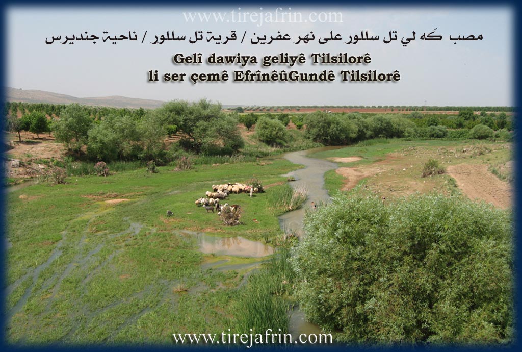
Other Landmarks: Çemê Efrînê
Summaries
I. Summary from TirejAfrin Site (English) of Tilsilorê
Source: https://www.tirejafrin.com/site/kura%20afrin%20Cindires%20-%20til%20silore.htm
According to the book جبل الكرد (عفرين) دراسة جغرافية Çiyayê Kurmênc (Efrîn): A Geographical Study by د. محمد عبدو علي Dr. Mihemed Ebdo Elî: Tilsilor, population 735, 160 houses.
Regarding the name Silûr, Yaqut al-Hamawi states that it comes from the Silûr fish "black fish" (catfish), which used to live abundantly in Çemê Efrîn (Efrîn river) and the lakes and springs that feed it. However, Abdullah al-Hilu in his book Historical Investigations (page 105) says that there is a disagreement regarding the Syriac or Greek origin of the village name, but that it is not Arabic in the sense of catfish. As for Tel, it is a well known Arabic word meaning hill.
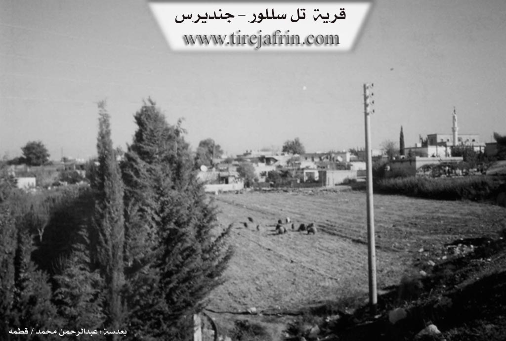
It is a medium sized village resting on the southern bank of Çemê Efrîn. Its old residences surround the archaeological Girê Tilsilorê (Tilsilor mound). In the vicinity of the village, especially in its east, there are traces of ancient settlement indicated by caves and hewn building stones that appear there. It is a beautiful summer village.
In the book عفرين .... نهرها وروابيها الخضراء Efrîn... Her River and Her Green Hills by the writer عبدالرحمن محمد Ebdulrehman Mihemed from the village of Qetme:
Tilsilor is a village in the Efrîn valley, administratively belonging to the Cindirês district, Efrîn region, Heleb governorate. It is a small village located on the left bank of Çemê Efrîn in a flat land that connects to the northwestern slopes of Çiyayê Seman. It slopes down towards Çemê Efrîn and is covered by fertile alluvial soil. It is located 4km southeast of the town of Cindirês. To its north lies an archaeological earthen mound (tell) scattered with pottery shards indicating its ancient habitation.
It is bordered to the north, 50 meters away, by the valley and course of Çemê Efrîn, the eastern Cindirês plain, and the village of Hacîler. It is bordered to the south by an agriculturally fertile plain, the northwestern chain of Çiyayê Seman, Xirbe Elûş, and Mezra Fîlk. To the west, it is bordered by Pira Tilsilorê (Tilsilor bridge), the valley of Çemê Efrîn, and the village of Medaya. To the east, it is bordered by a fertile plain planted with grains, cotton, and pomegranate orchards, and the village of Celeme.
The number of its houses is about 80 and its age is about 400 years. Its houses made of mud and stones with wooden roofs constitute the core of the village. Modern concrete houses have spread around it, most of which have extended towards the southwest along the paved road that connects it to Cindirês, as well as extending on the southern slope of the archaeological mound in the northern side of the village.
Available services include an electricity network, a primary school, a mosque, a telephone, and the archaeological mound. The village drinks from a water network connected to a well north of the village of Xezewiyê. To its west, a bridge was established connecting it to neighboring villages. It is connected to the town of Cindirês by a paved road. Mezra Fîlk is administratively attached to it.
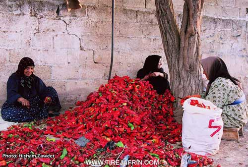
Its residents work in rainfed agriculture on an area of 410 hectares, producing grains and olives, and 80 hectares of irrigated land via pumping from Çemê Efrîn and artesian wells, producing crops such as cotton, sugar beet, pomegranate, and tobacco. A water spring bursts forth in its agricultural lands, forming a lake with waters from other springs, the water of which is utilized to irrigate the crops found around the village. They also raise sheep and cattle.
Village Mukhtar: Nafê Mihemed Elî
Preparation and Execution:
Manager of Tirej Efrîn website: Ebdulrehman Hacî Osman
20/12/2013
Sources
Book: جبل الكرد (عفرين) دراسة جغرافية Çiyayê Kurmênc (Efrîn): A Geographical Study by د. محمد عبدو علي Dr. Mihemed Ebdo Elî.
Book: عفرين .... نهرها وروابيها الخضراء Efrîn... Her River and Her Green Hills by عبدالرحمن محمد Ebdulrehman Mihemed from the village of Qetme.
II. Summary of Tilsilorê from Ax û Welat
Source: https://www.youtube.com/watch?v=oaZe291U_5Y
The village of Til Silûr, also referred to as Teslûr, is situated in the fertile Deşta Cûmê plain, approximately four kilometers southwest of the Cindirês district center in Efrîn. The village derives its name from the combination of "Til" (hill) and "Silûr," referring to the catfish found in the adjacent Çemê Efrînê. Residents state that the village was founded roughly 450 years ago. The original founders were two brothers from the Mala Mihemed Elî family. Initially, these early inhabitants lived in caves before constructing houses. Over time, the population expanded through marriage; notably, two early sons in law named Xelîl Silo and 'Umo joined the community, establishing the Mala Silo and Mala 'Umo lineages.
While the village is historically Kurdish, Arab families began settling there approximately 60 to 80 years ago. These communities describe their relationship as brotherly, sharing in both labor and daily life. The Arab residents belong to various groups, including the 'Ecacî and Hidêfî tribes, as well as the Silê Fatê and Bû Saleh families. The village economy is driven by agriculture, with residents cultivating olives, cotton, tobacco, wheat, and various vegetables like peppers and tomatoes.
A dominant landmark is Girê Çemê, a hill located north of the village. Beneath this hill lies a deep, ancient cave known as Şkefta Girê Çemê. This cave is historically significant and serves as a fishing spot, particularly for the Silûr fish. However, the site is considered dangerous; residents like Remzî recount stories of people drowning there, including a cousin and an Arab neighbor. Remzî shares a personal account of becoming trapped by fear in the cave late at night while fishing.
Another historical feature is Kaniya Gulbehirê, a spring located about two kilometers from the village. Residents believe the water source has Roman origins ("Rûmanî") and was historically channeled through a tunnel. For generations, this spring provided drinking water and served as a washing place for wool and wheat before modern plumbing was available. Elders like Siltan recall the arduous daily task of carrying heavy loads of water and yogurt to markets in Cindirês. Siltan also displays handcrafts made by Kurdistan, a young woman from the Şikê village who lived with Siltan's family before dying in the conflict.
II. Summary of Tilsilorê from Khalil Sino
The documentary explores the village of Tislûrê, shedding light on the daily lives, demographics, and social harmony of its residents. The host, Xelîl Sîno, visits the village to learn about its history and people, while also facilitating a charitable food distribution sponsored by Welîd Gumrukî from the Kurdaxê electricity workshop, who is noted to have a branch in Istanbulê and business ties in Tirkiyê.
During the visit, the host encounters a woman picking wild greens, such as mallow and mustard greens. She explains that although she currently lives in the village, she is originally from Efrîn and her family hails from Cindirêsê. She moved to the village after getting married and has remained there ever since. Later, the host speaks with a fifty year old woman named Afê, who was born and raised in the village. When asked about the name of the village, Afê notes that the name is of Arabic origin, though she does not know the specific story or meaning behind it.
Another older resident named Zelîxe shares her family history, stating that her father and grandfather were also from the area. Interestingly, she refers to her village as Tel Qesab. Both Afê and Zelîxe emphasize the unique and harmonious demographic composition of the settlement. The population is split evenly between Kurd and Arab families. According to Zelîxe, the two communities live together as one cohesive unit without any conflicts. They have organically integrated over time, with Arab residents learning Kurdish and Kurd residents learning Arabic. This mutual respect is further reflected in their daily traditions, such as sharing meals and supporting one another during times of need.
Despite the strong social bonds, the village faces several infrastructural challenges. While it boasts a mosque and an abundance of water wells that provide drinking water throughout the summer and winter, it completely lacks medical clinics, pharmacies, and commercial bakeries. Consequently, residents must bake their own bread using traditional tandoor ovens. When medical emergencies arise, they are forced to travel to larger neighboring towns such as Çil Axa, Girkê Legê, or Tirbespiyê to seek treatment.
The documentary highlights the spirit of community and resilience among the residents. The host purchases groceries from a local shopkeeper, during which the location of Pêncwînê is briefly mentioned, to provide an evening meal for several families, demonstrating the ongoing importance of charity and mutual aid. The broadcast concludes with deeply emotional musical performances dedicated to Efrîn. The songs express a profound longing for the homeland, celebrating its natural beauty, its olive trees, and the shared memories of its people, while holding onto the hope that they will one day return and rebuild Efrîn.
II. Summary of Tilsilorê from Multi Channel
The documentary explores the picturesque village of Tel Silor, located four kilometers south of Cindirês and sixteen kilometers west of Xezawiyê in the Efrîn region. The village derives its unique name from the catfish known locally as silor. In the past, the waters of Çemê Efrînê would flow into the caves beneath the northern hill, drawing massive schools of catfish from neighboring territories in Tirkiyê. Elders like Ebdulcelîl Şehade vividly recall standing at the entrance of Şikefta Tel Silor and hearing the dense, churning sounds of the fish swarms echoing from within the cave, comparing the noise of them bumping into one another to a herd of cows.
According to the local mukhtar, Ehmed Îsmaîl, the current settlement dates back 400 to 500 years, though the site itself harbors a much deeper history. The northern boundary of the village is dominated by an artificial mound called Tel Silor. Believed to date back to the Assyrian era, the hill has yielded historical artifacts including pottery, old lanterns, and individual ancient graves known as khashkhashat. Today, the village cemetery rests atop this historic mound.
The social fabric of Tel Silor is defined by a deep and harmonious coexistence between Kurdish residents and Arab residents. Kurds were the original inhabitants of the modern settlement, represented prominently by families such as Silêman and Mihemed Elî. Over time, Arab tribes migrated to the area, including segments of the Bû Şeban, Bû Selah, and Hedîdî tribes. Some of these groups relocated from the Îskenderûn region after facing difficulties in their homelands. Today, the population is evenly split. The community is highly integrated through intermarriage, and members of both groups are completely bilingual, sharing in the joys and sorrows of one another.
Farming serves as the backbone of the local economy. The village spans 500 hectares of fertile land irrigated by Çemê Efrînê and numerous artesian wells. Residents cultivate wheat, peppers, olives, and a variety of fruits. However, farmers currently face steep challenges. Locals like Reşîd Subhî explain that agricultural supplies are overly expensive and trade routes are closed. In recent years, the village has also become a refuge for displaced families escaping conflict in other parts of Sûriyê. The documentary highlights the struggles of Welîd Ehmed Elhesûn, a displaced man from the Elhemra area in eastern Hema who previously sought refuge in Erîha. He now lives in a mud floor tent and struggles to secure daily labor, as well as Remezan Ebû Elî, a displaced farmer from the village of Celemê who now tends to goats and leased agricultural land in Tel Silor.
The village is additionally home to a notable centenarian, Ebdulcelîl Şehade, who is believed to be around one hundred years old. Having migrated from Tirkiyê in his youth around the 1930s, he wandered through various towns before firmly settling in Tel Silor. He fondly recounts the vibrant community life of his early days, filled with festive dances during holidays. Despite failing eyesight and physical frailty, he retains a strong spirit, spending his advanced years reading the Quran and maintaining connections with his children spread across Serê Kaniyê, Heleb, and Îstenbol.
Transcriptions and Subtitles
| Source | Video | Subtitles | Transcript |
|---|---|---|---|
| Ax û Welat 1 | Watch Video | Download SRT | View Transcript |
| Khalil Sino 1 | Watch Video | Download SRT | View Transcript |
| Multi Channel 1 | Watch Video | Download SRT | View Transcript |
Foundation/Origin Information of Tilsilorê
A medium-sized village resting on the southern bank of the Afrin river. Its old dwellings are surrounded by the archaeological Tel Silur. In the village vicinity, especially to its east, are traces of an old settlement evidenced by caves and carved building stones that appear in it.
Source: TirejAfrin Site
The village was founded by the family of Mihemed Elî, who were first drawn to the area by the river and a large, deep cave that provided shelter. The community later expanded through the intermarriage of the founder's daughters with the Xelîl Silo and Umo families. An Arab community settled in the village approximately 60 to 80 years ago.
Source: Ax û Walat Transcript
Possible Village Name Meaning of Tilsilorê
About the name "سلور" Yaqut al-Hamawi says it comes from the سلور fish "the black fish", and it used to live abundantly in the Afrin river and the lakes and springs that feed it. As for Abdullah al-Hilu, he says there is disagreement about the origin of the Syrian or Greek village name, but it is not Arabic in the sense of سلور fish. As for Tel: it is a well-known Arabic word.
Source: TirejAfrin Site
Its name is derived from the Kurdish words for a local hill ('Til') and a specific type of fish ('Silor') that was once abundant in the adjacent Afrin River.
Source: Ax û Walat Transcript
V. Links
- Tirej Afrin:
https://www.tirejafrin.com/site/kura%20afrin%20Cindires%20-%20til%20silore.htm - Ax û Welat:
https://www.youtube.com/watch?v=h380LO5IWPY - Jawlat:
https://www.youtube.com/watch?v=vJH3NzWDdlw - Local FB page:
https://www.facebook.com/profile.php?id=100069122567268 - Link:
https://www.youtube.com/watch?v=oaZe291U_5Y - Khalil Sino:
https://www.youtube.com/watch?v=w-vmecvOAzw