General Information
Nahiya (Subdistrict)
Reco
Also Known As
Omar, Omar Oshaghi, Umera, Ûmera, عمر, عمر اوشاغي
Tribes
Milan, Omeran, Omranlî, Şêxan
Families, Clans, etc.
Bekir, Bilêl, Hisên, Kelkawî, Malê Nasûr, Mistefa, Mûs, Nesan, Reşik

Photos
Basic Information about Umera
Source: Ax û Welat
Springs: Kaniyê Sîmanê
Other Landmarks: Geliyê Sîmanê
Source: Afrin 366
Etymology: Named after the founder Omer who came from the plains and hid his farming equipment there; also called E'mmaro
Foundation Date/Period: Approximately 300 to 400 years ago
Caves: Bena Qawolê
Hills: Girê Omer
Ruins: Kela Zer
Summaries
I. Summary from TirejAfrin Site (English) of Umera
Source: https://www.tirejafrin.com/site/kura%20afrin%20%20%20Reco%20-%20umera.htm
It is stated in the book جبل الكرد (عفرين) دراسة جغرافية Çiyayê Kurmênc (Efrîn): A Geographical Study: Umera, Omer Uşaxî, Omer / 1029 inhabitants - 192 hectares - 9 km - 820 m /.
Etymology and Origins
The name derives from the proper name "Omer," and Omranlî: a clan of the Milan tribe in Mount Qerece Dax. It is a medium-sized village located on one of the southern peaks of Çiyayê Atmana and overlooks Deşta Amqê (the Amik Plain) from the west.
Location and Boundaries
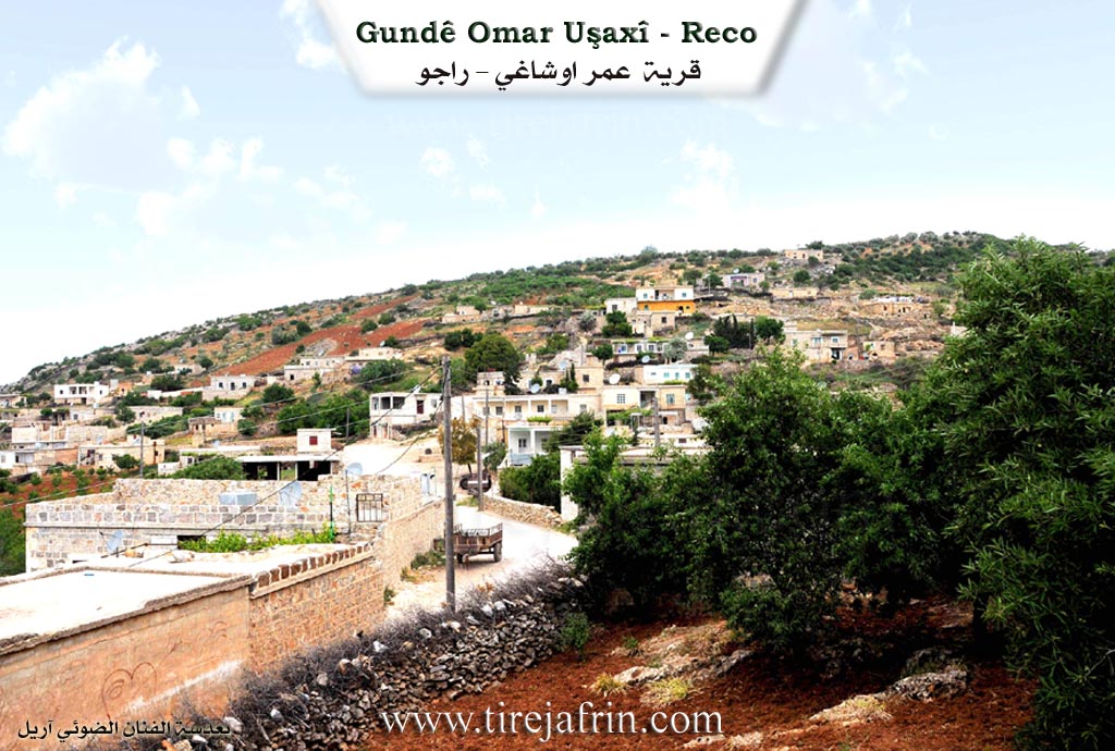
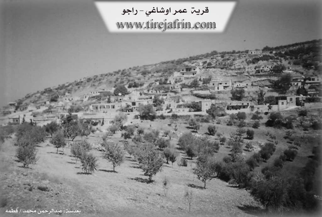
According to the book عفرين .... نهرها وروابيها الخضراء Efrîn... Her River and Her Green Hills: Omer Uşaxî is a village in Çiyayê Kurmênc following the Reco sub-district, Efrîn region, Aleppo governorate. It is a large village located in the middle section of the mentioned mountain on the western slope of a height overlooking Deşta Amqê, which has alluvial soil. It is located 9 km southwest of the town of Reco.
It is bordered to the north by a high mountain range planted with olive trees and the villages of Hesen Kelkewî, Kemreş, and Qûda; to the south by a harsh slope, a deep valley, and the village of Memel Uşaxî; to the east by a high mountain range planted with olive trees; and to the west by a harsh rugged slope, Deşta Amqê, the direct Turkish border, and the villages of Qele, Kûmêt, and Şadiyanlî.
Infrastructure and Housing
The number of houses reaches about 85, and the village is approximately 350 years old. Its dwellings are stone and mud with flat wooden roofs, and modern cement houses have spread to the north and east. An electricity network, a primary school, and a mosque are available in the village.
The residents drink from ponds and cisterns, and currently, they rely on artesian wells for drinking and irrigating orchards. The village belongs to the municipality of Memel Uşaxî. It connects to the sub-district center and neighboring villages via a leveled, unpaved dirt road. It is considered one of the beautiful villages in terms of location and modern construction on the highest mountain peak.
Agriculture
The residents work in rain-fed agriculture (olives, grains, vineyards, legumes) on an area of 192 hectares, alongside raising sheep and goats.
Administration
Village Mukhtar: Ezîz Mihemed Elî
Sources
- Book: جبل الكرد (عفرين) دراسة جغرافية Çiyayê Kurmênc (Efrîn): A Geographical Study by د. محمد عبدو علي Dr. Mihemed Ebdo Elî.
- Book: عفرين .... نهرها وروابيها الخضراء Efrîn... Her River and Her Green Hills by عبدالرحمن محمد Ebdulrehman Mihemed from the village of Qetme.
- Studies of Navenda Tirej Soft / Ebdulrehman Hacî Osman.
- Some residents of the villages.
Preparation and Execution: Manager of the Tirej Efrîn website: Ebdulrehman Hacî Osman 20/12/2013
II. Summary of Umera from Ax û Welat
Source: https://www.youtube.com/watch?v=FwukYv9Chrk
The village of 'Umera is characterized in this documentary primarily through its seasonal traditions and the oral history of its female elders regarding daily labor and survival in the past. While specific foundation dates or tribal affiliations are not explicitly detailed in the transcript, the residents paint a vivid picture of a community deeply rooted in agriculture and self-sufficiency.
Current life in 'Umera revolves around the preparation of winter reserves, known locally as leçer. The women of the village utilize the harvest to create various traditional foods. Grapes are processed into bastiq, dims (molasses), mîj, and kêsme. Pumpkins, specifically a variety referred to as kundirê qişê, are peeled and candied. Figs (hêjîr) are also central to the village's culinary culture; they are ground and mixed with gûz (walnuts) or kuncî (sesame) to create sweets served to guests.
Historically, life in 'Umera was defined by intense physical labor and water scarcity. An elder resident recounts that in previous generations, the village lacked convenient water sources such as wells (bîr) or cisterns (sehrînc). To sustain the community, residents traveled to a specific landmark known as Geliyê Sîmanê (The Valley of Sîman). Here, they utilized the Kaniyê Sîmanê (Spring of Sîman) to wash clothes and fetch drinking water, which they carried back to the village on their backs or using animals.
The agricultural history of 'Umera involved the entire community. Residents engaged in reaping (pale) and plowing (cotarî). The elder describes the use of a cer-cer, a threshing sled made of wood and iron pulled by animals, to process the harvest at the threshing floor. The women of the past were also skilled weavers and tailors, spinning wool from their own sheep to create clothing and mattresses, a skill set the elder notes has largely faded in the modern era as younger generations rely on purchased goods.
II. Summary of Umera from Afrin 366
Source: https://www.youtube.com/watch?v=kvIUSctlWmE
The documentary focuses on the village identified by the host as E'mmaro and by the elders as Gundê Omeran. Located in the highlands of the Afrin region, the village history is deeply intertwined with the lineage of a single progenitor named Omer. According to the village elder Abo Adham, the settlement was founded approximately three to four hundred years ago. The origin story recounts that Omer originally came from the Deşt or lowlands. He established a meqat (a summer farming site) at this location and hid his plough, known as derabetê xol, in the area. Because of this event, the site became associated with him, eventually evolving into the permanent settlement of Omeran.
The social structure of the village is defined by the direct descendants of this founder. The elder traces the lineage back seven generations, stating that the village population originated from two primary sons of Omer, named Mûs and Bilêl. These two ancestors represent the main branches of the village kinship structure. From the line of Bilêl, other family subdivisions emerged, including Reşik and Malê Nasûr. The elder explicitly details his own genealogy to illustrate the village age, reciting the line from Bilêl to Mistefa and then to Bekir, his own father. This patrilineal descent forms the core identity of the community, which now comprises roughly 300 households.
Historical and geographical landmarks play a significant role in the local narrative. The elder mentions a site called Girê Omer, where the founder reportedly settled. Furthermore, the documentary highlights ancient ruins located below the village. The most prominent of these is Kela Zer, or the Yellow Castle, situated about an hour's walk downhill. Close to this fortress, separated by about 200 meters, is a formation described as a ledge or cave like structure called Bena Qawolê. The elder provides a specific historical interpretation of this site, attributing it to the Qawol. He describes the Qawol as ancient Kurmanc people who followed the Zeredeştî (Zoroastrian) faith. This connection serves to assert a long standing Kurdish presence in the region dating back to pre Islamic times.
Despite the rich oral history, the residents note that physical artifacts have largely disappeared. The elder claims that during past conflicts and the arrival of foreigners, many tangible antiquities were removed or lost, leaving mostly the oral traditions and the names of the landscape, such as Kela Zer, as evidence of the past. The village maintains connections with its diaspora, with specific greetings sent to family members like Hoşeng living in Holenda. The narrative presents E'mmaro as a settlement that retains a strong memory of its origins through the Omeran lineage while preserving the names of ancient sites associated with the Qawol and Zeredeştî history of the region.
II. Summary of Umera from Multi Channel
The documentary explores the historical and social landscape of Omer Uşaxî, a picturesque agricultural village located in the Rajo district of the Efrîn region. Geographically, the village is bordered to the west by Deşta Kifrê, Deşta Şadiyan, and the borders of Turkey. To the east lie rugged mountains, Geliyê Xirbê, and the village of Dumîlya. The northern side features the village of Qûda and the towering Çiyayê Dûzdax, which reaches over a thousand meters above sea level. To the south, it is bounded by Çiyayê Îskender and the sister village of Mamel Uşaxî.
Historically, the current settlement of Omer Uşaxî was established three hundred and fifty to four hundred years ago. According to local elders, the original inhabitants previously lived to the west in an ancient valley settlement called Kanîko. Due to localized conflicts, they abandoned Kanîko and sought refuge in the higher, more defensible mountainous terrain where Omer Uşaxî stands today. The village name itself translates to the descendants or children of Omer, utilizing a Turkish term for children.
The residents belong entirely to the Şêxan tribe. Within this tribal structure, the village comprises several core families who share a common ancestry, most notably the Kelkawî, Nesan, Mistefa, and Hisên families. Historically, the region experienced open borders, and elders fondly recall traveling freely to Qiriqxan in Turkey to trade their goods at local markets.
The surrounding territory is rich with historical remnants from Greek, Roman, and Byzantine eras. The most prominent archaeological feature is Bîra Devfireh, an ancient Roman well situated in the old ruins of Kanîko. With a depth exceeding twenty meters, this well continues to provide pristine, ice cold drinking water to locals and passing shepherds. Further toward the border lies Qeleya Zer, an ancient ruin nestled between the local plains. The village also maintains deep spiritual traditions, centering around Ziyareta Se'bê. This sacred tree shrine serves as a spiritual focal point where locals tie threads and make wishes regarding marriage and personal fortune.
Economically, Omer Uşaxî depends heavily on goat herding and olive cultivation. Because the terrain is exceedingly rocky and harsh, modern agricultural machinery is useless. Consequently, farmers still rely on traditional animal drawn plows. The village is highly renowned for a specialized dry stone building technique known locally as mosaic or French wall construction. Learned generations ago by villagers traveling to work in Arab countries like Lebanon, this method involves shaping and tightly stacking rocks without mortar to create beautiful, durable agricultural terraces and homes.
During the documentary visit, the community was celebrating a traditional wedding in the main village square known as Qada Dolab. Residents from neighboring villages like Qemereş joined the festivities, showcasing traditional garments, vibrant folk dances, and the deeply rooted communal solidarity that defines Omer Uşaxî.
Transcriptions and Subtitles
| Source | Video | Subtitles | Transcript |
|---|---|---|---|
| Afrin 366 1 | Watch Video | Download SRT | View Transcript |
| Ax û Welat 1 | Watch Video | Download SRT | View Transcript |
| Multi Channel 1 | Watch Video | Download SRT | View Transcript |
Possible Village Name Meaning of Umera
From the proper name "Omar" (عمر), and Omranli (عمرانلي): a clan from the Mellan (ملان) tribe in Qara Jah Dagh (قره جه داغ) mountain.
Source: TirejAfrin Site