General Information
Nahiya (Subdistrict)
Efrîn
Also Known As
Birc Ebdalo, Bircê, Birj Abdalo, Birj Abdullah, Burj Ebdalo, Colaqa, برج عبدالله, برج عبدالو
Tribes
Imêratî, To'ta, Xaltî
Families, Clans, etc.
Arif Betal, Baqûbî, El Qeckê, Evdalo, Evdêl, Evdêlok, Kalo, Kelaho, Keyalî, Mala Aloyê Dêla Hesen, Mala Arif Axa, Mala Dewşê, Mala Ehmedê Hesenê Elû, Mala Evdalê Şemsê, Mala Hesenê Nebî, Mala Hesenê Osmên, Mala Hesenê Usmên, Mala Hisên Îso, Mala Keyalî, Mala Kuleh, Mala Kîkî, Mala Mela Osmên, Mala Mele Usmên, Mele Osman, Nebî Hesen, Sîdo Mîmî, Yeqûb, mala Ebdal, mala Ebuzan, mala Lêylû, mala Mihemed Cimo

Photos
Basic Information about Bircê
Source: Ax û Welat
Etymology: Named after Birca Evdal or Birca Evdêl (Tower of Evdal), where a solitary man named Evdal (or Ebdê Şemo) once lived
Caves: Dûderî, Şkefta Mala Hesenê Usmên, Şkefta Ehmedê Hesenê Elû, Şkefta Mala Mele Usmên
Springs: Ser Çem
Hills: Çiyayê Lêlûn, Tilê Ûsib, Til Amos, Girê Usib axa
Shrines: Tirba Kuleh
Ruins: Birca Evdal, Keleha Batolê Batêl, Qişle, Pira kevn
Wells: Bîrê me
Other Landmarks: Bendava Birc Ebdalo, Bendê Heno, Geliyê Dûderî, Geliyê Husênê, Geliyê Qertel, Geliyê Piling, Çemê Efrînê
Source: Afrin Zeyton
Etymology: Named after a dervish named Ebdal who took shelter in a tower (burc) that stood in the center of the village
Foundation Date/Period: Approximately 300 years ago
Ruins: Qişlê, Burc
Other Landmarks: Efrîn
Summaries
I. Summary from TirejAfrin Site (English) of Bircê
Source: https://www.tirejafrin.com/site/kura%20afrin%20markaz-bircke%20abdalo.htm
It is stated in the book جبل الكرد (عفرين) دراسة جغرافية Çiyayê Kurmênc (Efrîn): A Geographical Study by د. محمد عبدو علي Dr. Mihemed Ebdo Elî: Birc, Birc Ebdalo, Birc Ebdellah / 1962 inhabitants - 150 houses - 12km - 240m /:
Its name is attributed to an archaeological tower (Birc) that existed in the center of the village, and to the name of its first inhabitant Evdal, which is a local Kurdish variation of the name Ebdellah, which was adopted again as the name of the village after Arabization.
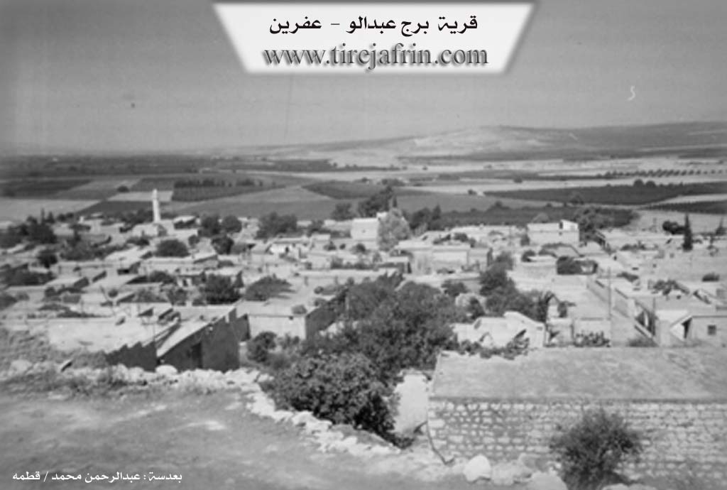
It is stated in the book عفرين .... نهرها وروابيها الخضراء Efrîn... Her River and Her Green Hills by the writer عبدالرحمن محمد Ebdulrehman Mihemed from the village of Qetme:
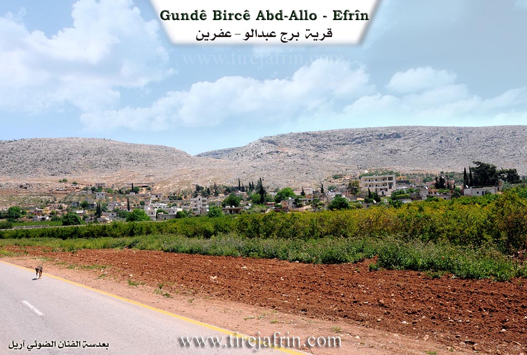
Birc Ebdalo is a village in the Cûm plain and the Efrîn valley, belonging to the villages of the Efrîn center and district, Heleb governorate. It is a large village located on a limestone plateau and the Cûm plain on the western slope of Çiyayê Seman and Lêlûn. It is 15km away from the city of Efrîn towards the south.
It is bordered to the north by a wide and agriculturally fertile plain, the valley of the Efrîn river, and the village of Kefêr. To the south, it is bordered by a fertile agricultural valley and plain, Girê Temûs planted with pomegranate and apple trees, and the village of Xezawiyê. To the east lies a rugged and elevated mountain range of Çiyayê Seman and Lêlûn and the villages of Kîmar and Brad. To the west, there is a wide and agriculturally fertile plain, the valley of the Efrîn river, some orchards planted with pomegranates, apples, and olives, and the village of Kefer Zît on the highest elevation on the western side of the Efrîn river.
The number of its houses is approximately 200, and its age is approximately 400 years according to the statements of the citizen Hesen Nebo. Its old houses are made of stone and mud with wooden ceilings, while the modern ones are made of stone and cement. The village has expanded to the north, south, and east, and on both sides of the Riya Xezawiyê-Efrîn (Xezawiyê-Efrîn road). An electricity network is available, as is drinking water from Kaniya Birc Ebdellah located on the northern side of the village. It has a primary and middle school. It belongs to the Basûtê municipality. The road leading to it is paved and connects with the region and neighboring villages. Several streets have been paved by the Basûtê municipality. There is an old archaeological spring from the Roman era next to the village on the northern side.
Its residents work in the cultivation of cereals and olives through rain-fed farming, and the cultivation of pomegranates, cotton, sugar beets, apples, and vegetables through irrigation from the Efrîn river or artesian wells dug within the orchards.
According to the statements of one of the residents, the first founder of the village is Ebdalo, in reference to the village of Birc Ebdellah. Among its most important families are Arif Betal (Sîdo Mîmî), Yeqûb (Baqûbî - Kelaho), and El Qeckê, and they were the first to inhabit the village. It is a beautiful village in terms of location and general view, surrounded by pomegranate, walnut, and apple trees from all sides. From the village comes Betal Arif, a former member of the People's Council, and the lawyer Mihemed Nûrî Arif, one of the first lawyers in the Efrîn region.
Village Mukhtar: Ednan Elî
Preparation and Execution:
Manager of Tirej Efrîn website: Ebdulrehman Hacî Osman
20/12/2013
Sources:
- Book: جبل الكرد (عفرين) دراسة جغرافية Çiyayê Kurmênc (Efrîn): A Geographical Study by د. محمد عبدو علي Dr. Mihemed Ebdo Elî.
- Book: عفرين .... نهرها وروابيها الخضراء Efrîn... Her River and Her Green Hills by عبدالرحمن محمد Ebdulrehman Mihemed from the village of Qetme.
- Statements by resident Hesen Nebo.
- Statements by some residents of the village.
II. Summary of Bircê from Ax û Welat
Source: https://www.youtube.com/watch?v=NFSOqcbBvmE
The village of Bircê Ebdalo, located in the Şêrawa district of Efrîn, sits between Deşta Cûmê and Çiyayê Lêlûn. Its name originates from a historical structure known as Birca Evdal (The Tower of Evdal). According to local oral history recounted by elder Tahir Kuleh, a solitary man named Evdal, also identified as Ebdê Şemo, lived in this tower long ago. While the tower itself is ruined, its foundation stones were incorporated into the home of the Mala Keyalî family.
The village is historically significant for its deep roots and connection to the surrounding landscape. To the east lies the Çiyayê Lêlûn mountain range, home to the famous Dûderî cave. This cave is a major archaeological site where a joint Syrian Japanese team discovered the skeletal remains of a two year old Neanderthal child in 1993, dating back approximately 60,000 years. Archaeologist Hîşam notes that the burial style, with limbs folded against the chest, indicates that the Neanderthals possessed spiritual beliefs about the afterlife. Local resident Emîne participated in these excavations, sifting through soil to find flint tools and animal bones.
Socially, Bircê Ebdalo is defined by a strong bond between its Êzîdî, Misilman, and Ereb residents. They share a single cemetery and participate in each other's religious rites. The village is home to several prominent families, including Mala Mele Usmên, Mala Evdalê Şemsê, and Mala Hesenê Usmên. Some families, such as Mala Kuleh and Mala Ehmedê Hesenê Elû, historically lived in specific caves within the village before modern housing was built. The Arab population, including Mala Hisên Îso and Mala Kîkî (locally called Malê Têt), migrated to the village about a century ago from Tirmonînê and belong to the Imêratî tribe or To'ta group.
The village is also known for the Bendava Birc Ebdalo (also referred to as the dam of Basûtê), constructed on the Çemê Efrînê around 1998. This dam transformed the local economy, allowing for the extensive irrigation of pomegranates (hinar), pears (armûd), and peaches. Historical landmarks include the ruins of Keleha Batolê Batêl, a fortress used by the figure Batolê Batêl to fight against the Ottomans, and Tilê Ûsib, a hill associated with an ancient wheelwright. The village preserves unique traditions, such as the "Bisk" ceremony, a hair cutting ritual for young children rooted in the lineage of Îbrahîm Xelîl.
II. Summary of Bircê from Afrin Zeyton
Source: https://www.youtube.com/watch?v=TIALTm8oVy0
The village of Burc Ebdalo, located in the Afrin region, possesses a history deeply rooted in the migration narratives of the Xaltî tribe. The name of the village carries a specific etymological origin described by local elders: approximately three centuries ago, a tower (burc) stood in the center of the settlement. A dervish named Ebdal arrived and took shelter within this structure. Consequently, the locals named the location Burc Ebdalo (Ebdal's Tower) in his honor. While the original tower is described as an old archway or ruin (qentermokî kevn) that is no longer standing, it remains the defining historical marker of the village's identity.
The history of the community is one of migration and settlement. Residents trace their ancient origins to the Botan region (specifically Jizîra Bota), a land associated with the famous Kurdish epic of Mem û Zîn. From Botan, the ancestors of the current villagers moved to Îsko, where they were established for a time. Eventually, they migrated to the current location of Burc Ebdalo. An elder notes that for much of their history, the Kurds in this area were mountain dwellers, living in tents (kon) and temporary encampments (war) rather than permanent stone villages. Significant settlement into the current housing structures occurred more recently, with one elder recalling the village being built up roughly 70 years ago, transitioning from older habitation sites like Qişlê, a ruined site located to the north of the current village.
Socially, Burc Ebdalo is defined by the coexistence of Êzdî and Misilman families. The village comprises approximately 200 households, with the majority (around 140) being Êzdî. Elders emphasize a strong tradition of brotherhood and "oneness" between the two religious groups. They recount that in previous generations, Êzdî residents would specifically ask their Misilman neighbors to perform the slaughter of animals for feasts to ensure the food was religiously permissible for everyone to eat, fostering a communal atmosphere where holidays and funerals are shared without division.
Prominent families in the village history include Mala Mela Osmên, described as a native and established lineage, and Mala Hesenê Osmên. Another key family, Mala Kuleh, is recorded as having lived at the Qişlê site before moving down to the main village as the settlement expanded.
Economically, the village relies on agriculture, supported by the nearby Efrîn river and local wells. While traditional crops include wheat, lentils, and chickpeas, the village is also known for its orchards producing pomegranates, pears, and apples. In the last five to six years, the agricultural output has diversified to include new crops such as potatoes, anise, and safflower.
II. Summary of Bircê from Multi Channel
This documentary transcript features an eighty two year old man recounting the history, landscape, and social life of his home village of Zaretê, situated on the rugged terrain of Çiyayê Lêlûn in the Efrîn region. The locals, who are sometimes referred to by the nickname Seyfiyê, are described as a peaceful and hardworking Muslim community. According to the elder, the mountain was entirely barren in the past. Through intense manual labor, the villagers transformed the rocky landscape by planting olive trees, pomegranate orchards, wheat, and barley.
A major historical event in the collective memory of Zaretê involves a significant archaeological excavation in a large two story cave located in a nearby valley. The speaker recalls when Japanese archaeologists, whom he refers to as Yabanî, arrived to excavate the ancient site. The local villagers, including men, women, and youths, worked alongside the foreign team for two to three years. During their digging, they uncovered the ancient skull and remains of a small child. The researchers carefully packed the ancient skeleton into a box and transported it to Ewropa.
The elder also shares detailed memories of his youth and his interrupted educational journey. Growing up, the village had a vibrant social life where people deeply respected one another, the local girls freely spoke Kurmanji, and neighbors frequently visited each others homes in the evenings. His education began with religious instruction when he completed his reading of the Quran under the guidance of a teacher named Şêx Faris. He then enrolled in formal schooling in the nearby village of Îskê. Because he already knew how to read, he was placed directly into the second grade, even though he had not yet learned how to write.
He later continued his studies in the village of Basûtê before transferring to a school in the city of Efrîn. Unfortunately, his formal education was cut short due to severe financial hardship. The school in Efrîn required a five lira fee for an economy fund, and despite searching the entire village, his father was unable to raise the money. Despite dropping out, the speaker remained fiercely dedicated to learning. He independently studied grammar, composition, and mathematics, eventually reaching a level where he was tutoring ninth grade students. Many of the local children he helped educate went on to earn their baccalaureate degrees, and they continue to treat him with immense respect today.
The account concludes with a poignant reflection on the current state of the region. The elder expresses a deep longing for peace, urging an end to the ongoing war so that all displaced people and strangers can finally return safely to their own homes.
II. Summary of Bircê from Multi Channel 2
Birc Ebdalo is a historic village situated on the northwestern slopes of Çiyayê Lêlûn in the Efrîn region. Bordered to the north by the Ava Efrînê river, the village boasts a profound historical legacy. Between 1989 and 1993, a joint Japanese Syrian archaeological expedition discovered a 100,000 year old child skeleton in Şikefta Duderiyê, a cave located in the southern hill known as Girê Mûsa.
Historically, early inhabitants of the area lived in the caves of Girê Mûsa, which feature rooms carved directly into the rock. Settlement later moved to a northern hill called Girê Qişlê or Qişle, where ancient rock carved storage bins and ruins still exist. According to the village mukhtar Kamîran Mistefa, the residents moved down from Girê Qişlê to the current village location around 200 to 250 years ago. The village itself derives its name from a Roman watchtower originally built to protect the Silk Road and military caravans. Legend states that a man named Ebdalo lived beside the ruins of this tower, leading to the name Birc Ebdalo. The stones from the ancient tower were eventually repurposed to build modern homes, including a residence constructed by Şêx Omer Keyalî.
The social fabric of Birc Ebdalo is diverse and known for its tolerance. The original population of about 400 families consists of Arab, Sunni, and Êzîdî residents, alongside internally displaced persons who work as agricultural laborers. Prominent locals interviewed include Omer Reşîd, Mistefa Osman Elî, and Mihemed Xelîl Kalo, who served as a religious reference for the Êzîdî community in Efrîn. The Êzîdî population shares many customs and burial rites with their Sunni neighbors but maintains distinct religious traditions. These include a three day fast in December, the Xidir Îlyas holiday in February, and the Spring New Year in April.
Culturally, Birc Ebdalo shares deeply rooted folklore with neighboring villages such as Xezawiyê, Kefirzêtê, and Basûtê. The locals preserve traditional Kurmanji music, famously singing the tragic ballad of Eyşanê, a bride whose soul was taken by Azrael on her wedding night. Economically, the village functions as an agricultural and tourist hub. A prominent dam lake on Ava Efrînê irrigates lush orchards of pomegranates, apples, and quince. The surrounding forests, scenic riversides, and local restaurants once made Birc Ebdalo a popular destination for visitors seeking nature and heritage.
II. Summary of Bircê from Multi Channel 3
The village of Birca Evdalo, also referred to as Birc Ebdella, is situated twelve kilometers from the city of Efrîn in the Şêrewa district. The settlement is over 150 years old. Originally, the villagers lived on higher ground at a location known as Qişle. They eventually moved down into the valley to be closer to Kaniya Birca Evdalo, a spring that allowed them to cultivate crops and access water more easily. According to the local mukhtar, Kemeran Mistefa Elî, the village derives its name from a dervish named Evdal or Evdalo. He took shelter in a small tower called a bircik located in the center of the area, prompting the community to name the village Birca Evdalo in his honor.
The foundational lineage of the village rests upon several core families, including the Nebî Hesen, Mele Osman, Evdalo, Evdêl, and Evdêlok families. A defining characteristic of Birca Evdalo is the harmonious coexistence of Êzîdî and Muslim residents. About one third of the village is Êzîdî. Elders proudly explain that both groups share a single cemetery and celebrate religious holidays together. The Êzîdî community observes traditional fasting periods, celebrates Çarşema Sor in the spring, and undertakes the pilgrimage to Laliş in Iraq, while also joining their Muslim neighbors for Islamic holidays like the feast of Qurban.
Historically and archaeologically, the village is exceptionally significant. Locals point out several ancient landmarks including the hills of Tiliya Ûsiv Axa, Tiliya Ber Gir, Tila Mûsê, and Têl Çawer. An elder notes that the village holds deep historical layers comparable to the ancient temple found at the nearby Tila Enydarê. A prominent archaeological site is a cave called Didarî located in Cebel Bircê. Decades ago, a Japanese expedition spent time excavating this cave with the help of local workers. They discovered the skeletal remains of a young child and ancient tools dating back tens of thousands of years, proving the deep antiquity of human habitation in the valley.
Today, Birca Evdalo is renowned for its agriculture and its high number of educated professionals, including doctors and pharmacists like Xelîl Batal Arif and Doktor Seydelî Cemîl Batal. The orchards are filled with apples, pomegranates, and specialized pear varieties. Furthermore, the village possesses a rich cultural legacy. It is the birthplace of Koma Agirî, a pioneering Kurdish musical and theatrical group founded in 1986 by local figures such as Nûrî Reşîd, Ebdile Berekat, Elî Misto, Ebû Şivan, and Ebû Selah Mistefa Osmo. Inspired by legendary artists like Şivan Perwer, the group performed plays like Ala Hêvî and Kawa, keeping Kurdish heritage alive across the Efrîn and Heleb regions.
II. Summary of Bircê from Afrin 366
Source: https://www.youtube.com/watch?v=Jzewpv1C0Ks
This documentary explores the village of Burj Ebdalo, also referred to by elders as Birc Abdul, located in the Efrîn region. The hosts journey through the village to document its current state, geographical layout, and the lives of its inhabitants. They are guided by a request from a former resident named Rênas, and they specifically visit the home of her family, the household of Mihemed Cimo, who is also known as Ebû Kawa.
The history and etymology of the village are deeply tied to its original founders. According to a local elder, the village was named after a man named Ebdal from the mala Ebdal lineage. Ebdal was the individual who initially established and built the settlement. Over time, the village experienced significant growth. The elder recalls a period when the settlement consisted of only fifty homes. Today, the village has expanded considerably and contains approximately three hundred houses.
Geographically, the village is situated in a mountainous and fertile area within Efrîn, surrounded by the high peaks of Çiyayê Efrînê. Agriculture serves as the foundation of the local economy. The villagers cultivate a variety of crops, including lentils, barley, and wheat, alongside numerous fruit trees and olive groves.
The social fabric of the village is tightly bound, with residents maintaining a strong connection to their land and community. Elders frequently reminisce about the past and the communal spirit that characterized village life. They recount stories of earlier generations and mention local figures such as Am Berzencî, Xal Sûfî, Am Hesen, Ebdillah, Am Xeyrî, and Am Nûrî Hacî Haş. These individuals were well known among the local tribes and played vital roles in the social life of the community. Other individuals mentioned during the cultural discussions include Cewad, who is credited with gifting a musical instrument, and Nûrî.
During their tour, the hosts visit several households, including the home of Ebuzan and the household of Lêylû. They observe the traditional stone architecture of the village, noting how many of the courtyards and homes are built with sturdy materials suited for the mountain environment. However, they also document several abandoned or empty houses, reflecting the displacement that has impacted the region. Despite these challenges, the returning residents and the remaining villagers continue to maintain their customs, such as preparing traditional foods during festive times like Cejna Erefatê. The village cemetery, described as a resting place for the ancestors, stands as a testament to the enduring presence of these families on their ancestral land. Burj Ebdalo retains its reputation as a prosperous and beautiful village, cherished deeply by its diaspora community now living in places like Heleb and beyond.
II. Ax û Walat Book 2
77
BIRC EBDALO
7.7.2017
The village of Birc Ebdalo is affiliated with the Şêrewa district of the Efrînê canton, located 14km south of the city of Efrînê and 5 km south of the town of Basûtê.
It is said that a person named (Evdalê Şemo) settled in the location of the village, and because, like all the ancient villages of the Şerewa district, it had a tower that was like a mansion, this name was given to it.
The people of the village were all formerly Yazidis, but after the Ottoman occupation imposed its rule over the region, many families became Muslims, but other families did not abandon their religion and have preserved it to this day.
78
There are around 250 houses in the village, and nearly 2000 people live there. There are 3 Arab families in the village.
All the components of the village, Yazidis, Muslims, and Arabs, have good relations and act as one family in joy and sorrow.
There are 5 families in the village:
The family of Qirn Os or Mihemed Xalî, Bêrem, Şêx Zêdo, Ebdalê Şemso, and the Elo family.
To the east of the village is the Lêlûn mountain range, in which the Duderî cave is located. The age of this cave goes back 4000 years.
The land and fields of the village are suitable for agriculture, so the people of the village make their living by cultivating olive groves, pomegranates, apples, and many other types of fruits like apples, peaches, apricots, quinces, medlars, etc., and they sell their products in the markets of Efrînê.
Along with agriculture, some families also raise sheep for home consumption and also for sale. A few people also work as employees in the institutions and bodies of the Autonomous Administration.
To the south of the village, there are many caves named (Tilemosê). They are very ancient, and their history goes back to the era of the caves.
To the east of the village is the Kûr valley; it is a valley that starts from the village of Kîmarê and goes south, and is named the valley of
79
Duderî. Beyond it lie the Husêniyê valley, the Qertel valley, and the Piling valley.
To the west is the Efrînê river, on which a dam has been built, and the Ûsib Axa hill. And to the north is a barracks near which there is a water well; it was a place for picnics and gatherings for the people of the village, but unfortunately, now only a few ruins are visible, remaining.
There is a water dam on the Efrînê river near the village, 2 km away, which was built in 1998. This dam is used for irrigating agricultural fields and irrigates nearly 600 Hectares of land, so farmers grow beets, wheat, and cotton around the dam.
This dam has provided great benefits to the village by improving the agricultural situation on one hand and increasing the farmers' agricultural products on the other.
Şêx Mihemed Kalo is one of the Yazidi religious figures in the village. He has put a lot of effort and work into preserving the Yazidi religion, and he is a respected and honored figure among the people of the village and all the surrounding people.
Transcriptions and Subtitles
| Source | Video | Subtitles | Transcript |
|---|---|---|---|
| Afrin 366 1 | Watch Video | Download SRT | View Transcript |
| Afrin Zeyton 1 | Watch Video | Download SRT | View Transcript |
| Ax û Welat 1 | Watch Video | Download SRT | View Transcript |
| Multi Channel 1 | Watch Video | Download SRT | View Transcript |
| Multi Channel 2 | Watch Video | Download SRT | View Transcript |
| Multi Channel 3 | Watch Video | Download SRT | View Transcript |
Foundation/Origin Information of Bircê
The first founder of the village was Abdul Wa. Among its most important families are Aref Battal (Sido Mimi) - Yacoub (Baqoubi - Klaho) Ali Qajkeh - and they are the first to inhabit the village.
Source: TirejAfrin Site
The modern village was established on land that was previously a pasture. Its contemporary social fabric was formed around 70-80 years ago with the arrival of the first Yazidi families, including one from Khaltan in the Botan region, who joined a previously all-Muslim community.
Source: Afrin Zeyton Transcript
Possible Village Name Meaning of Bircê
Its name is attributed to an archaeological tower that existed in the center of the village, and to the name of its first inhabitant "Abdal," which is a local Kurdish modification of the name "Abdullah".
Source: TirejAfrin Site
Its name originates from an ancient, two-story tower of asceticism once inhabited by a dervish named Abdalo.
Source: Afrin Zeyton Transcript
V. Links
- Tirej Afrin:
https://www.tirejafrin.com/site/kura%20afrin%20markaz-bircke%20abdalo.htm - Ax û Welat:
https://www.youtube.com/watch?v=NFSOqcbBvmE - Jawlat (post-2018):
https://www.youtube.com/watch?v=zV0UVqjpSQg - Gundên Me (post-2018):
https://www.youtube.com/watch?v=TIALTm8oVy0 - Drone video:
https://www.facebook.com/radyodelal/posts/pfbid01Fv5A4d5T69UBGNtE7ctAvXdLfCWVyqXLq6R61BNa8boFgYJZw5tK7K8WGrYZjWLl - Link:
https://www.youtube.com/watch?v=M47MskVyfvI - Link:
https://www.youtube.com/watch?v=8vSnv_b_gDA - Link:
https://www.youtube.com/watch?v=QeRPEv3IBTY - Link:
https://www.youtube.com/watch?v=UU6s-dv4P6M - Link:
https://www.youtube.com/watch?v=w92uAJdmAPA - Link:
https://www.youtube.com/watch?v=focOuf5GhlY - Multi Channel:
https://youtu.be/V_j4a-s_GFw?si=RjyVLmj8UtQbUyUh - Afrin 366:
https://www.youtube.com/watch?v=Jzewpv1C0Ks