General Information
Nahiya (Subdistrict)
Mabeta
Also Known As
Al-Amiriyah, Hise, Husê, Mirka, Hemtato, Mirkan, Mirkanli, Mîrka, Mîrkan, Ĥem Tato، الأميرية, الأميرية, حسة, ميركان, حسه, كونده حسه, ميركو
Tribes
Behdînî, Mîrkan, Mîrko
Families, Clans, etc.
Ebdî, Ebû Ciwan, Ebû Kawa, Elîk, Elîko, Gelerî, Genço, Hanan, Hec Emîr, Hec Selîm, Hemalîk, Hemlîko, Hemtet, Hesîko, Mala Cefir, Mala Goro, Mala Gênco, Mala Hemolîk, Mala Hemtat, Mala Sînê, Malê Cepiro, Malê Guro, Malê Gênco, Malê Hemalîkê, Malê Hemtatê, Malê Kêlo, Malê Sînê, Silêman, Sîno, Çapira

Photos
Basic Information about Mîrka
Source: Ax û Welat
Etymology: Originally called Mîrka, then Hemtatu (after the founder Hemtat), and finally Gundê Hisê (after Hisê, the son of Hemtat)
Old Names: Hemtatu, Hisê
Foundation Date/Period: More than 350 years ago
Trees: Darik çinarê
Wells: Bîra gundê Husê
Source: Afrin 366
Etymology: The village is primarily known as Mêrkan or Gundê Hisê. It has several names, including Amîrî. Historically, Ereb neighbors referred to it as Hemto to.
Foundation Date/Period: 300-400 years ago
Hills: Vêla Sînemê, Koxrê, Hec Hesna
Ruins: Xirbê me
Trees: Darê Hinarê
Other Landmarks: Birîmce, Şîtka, Gund Bêlwehan
Summaries
I. Summary from TirejAfrin Site (English) of Mîrka
Source: https://www.tirejafrin.com/site/kura%20afrin%20%20%20mebetli%20-%20mirka.htm
The following states in the book جبل الكرد (عفرين) دراسة جغرافية Çiyayê Kurmênc (Efrîn): A Geographical Study by د. محمد عبدو علي Dr. Mihemed Ebdo Elî: Gundê Husê, Hem Tato, Mîrkan, El Emîriye / 3085 inhabitants - 920 H - 5 km - 630 m /:
This village has three local names, all of which are of Kurdish origin:
Mîrkan: The plural of "Mîr" (Princes). It is the name of a Kurdish tribe found in Mount Şengal (Lîrx, p. 51).
Gundê Husê: A proper name derived from Huseyn.
Hem Tato: Meaning Mihemed "the Tat". He was nicknamed this because he was blond and fair-skinned, resembling the Tat people. This is a characteristic of some residents of Mount Seman known for their white skin.
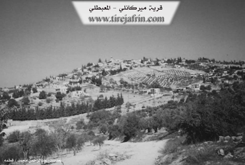
It is a large village located on the surface of a plateau at the beginning of the Xastiya valley. It contains commercial shops and small vocational workshops. Its mosque is perhaps the oldest in the region, with its construction dating back to the beginning of the twentieth century.
The following states in the book عفرين .... نهرها وروابيها الخضراء Efrîn... Her River and Her Green Hills by the writer عبدالرحمن محمد Ebdulrehman Mihemed from the village of Qetme:
Mîrkanlî is a village in Çiyayê Kurmênc, administratively belonging to the district of Mabeta, in the Efrîn region, Heleb governorate. It is a large village located in the central part of Çiyayê Kurmênc, on the surface of a rolling limestone plateau, furrowed by watercourses heading towards the northeast and southwest. Its soil is clay/argillaceous, and forests and pastures are spread across it. It is 5 km away from the district center towards the southwest.
It is bordered to the north by slopes, watercourses, and the village of Berîmce. To the south, it is bordered by a watercourse, the valley of Cercim, and the villages of Şêrkanlî and Îkî Axur. To the west, it is bordered by a slope, the valley of Cercim planted with olive, walnut, and apricot trees, high mountain elevations, and the village of Mistû Aşûr. To the east, it is bordered by slopes, several watercourses planted with olive trees, and the village of Darkîrê Mezin.
The number of houses reaches 350, and its age is approximately 400 years. Its old houses are made of stone and mud with flat wooden roofs, while the modern ones are of stone and cement, spreading towards the south and west up to the village square next to the public road. An electricity network is available. The village drinks from a water network branching from the Berîmce village water network and from local wells. It contains a primary school, a preparatory school, telephone service, a mosque, and an agricultural cooperative society. There are four modern olive presses in the village. It is connected to the district center by a paved road which passes through its center to several neighboring villages.
The residents work in rain-fed agriculture on an area of 880 hectares, growing grains, olives, legumes, and other fruit trees. The remaining 40 hectares are irrigated from artesian wells (summer vegetables, pomegranates, walnuts, and apricots) in the plain of the Cercim valley up to the valley of the Rotanlî spring, in addition to raising sheep and goats. Currently, the village drinks from a modern water network in the south of the village in the Cercim valley at (Şbîrlaq).
The village is divided into three sections: a northern section at the top of the elevation, a second section in the middle, and a third section in the south and around the public road. Here, there are several blacksmithing shops and commercial stores. Among its most important families are the Hemlîko, Elîko, and Silêman families.
Village Mukhtar: Mistefa Xelîl Qadir
Preparation and execution:
Manager of Tirej Efrîn website: Ebdulrehman Hacî Osman
20/12/2013
Sources:
- Book: جبل الكرد (عفرين) دراسة جغرافية Çiyayê Kurmênc (Efrîn): A Geographical Study by د. محمد عبدو علي Dr. Mihemed Ebdo Elî.
- Book: عفرين .... نهرها وروابيها الخضراء Efrîn... Her River and Her Green Hills by عبدالرحمن محمد Ebdulrehman Mihemed from the village of Qetme.
II. Summary of Mîrka from Ax û Welat
Source: https://www.youtube.com/watch?v=SM8rsva4AaQ
Located in the Mabeta district of the Çiyayê Kurmênc region in Efrîn, the village commonly known as Gundê Hisê (or Hisên) has a distinct tripartite naming history reflecting its origins. According to village elder Mihemed, the settlement was founded more than 350 years ago by an individual named Hemtat, who migrated from Sîncar (Sinjar) in Başûrê Kurdistanê. Upon his arrival, the site was initially associated with the Mîrkan tribe (referred to as "Eşîra Mîrko"), giving it its first name, Mîrka. Later, it became known as Hemtatu or Gundê Hemtatê in honor of the founder. Eventually, the name changed a third time to Gundê Hisê, named after Hisê, the son of Hemtat.
The social structure of the village is defined by six primary families (malbat): Mala Cefir, Mala Sînê, Mala Hemolîk, Mala Hemtat, Mala Goro, and Mala Gênco. Today, the village comprises approximately 350 households. It serves as a strategic economic hub for the surrounding area, particularly after the establishment of a local Tuesday market (Bazar) following the declaration of Democratic Autonomy. This market serves as a commercial center for roughly 15 to 20 nearby villages, including Sotiya, Selo, and Xozana.
Economically, Gundê Hisê is renowned for its agriculture, specifically olive and sumac production. The head of the village council notes that unique olive varieties grow here, such as Zeytûnê Kêlo, Xelxalî, and the oil-rich Zeytûnê Zêtî. The village is a powerhouse for sumac, producing an estimated two-thirds (over 250 tons) of the total sumac yield in the Efrîn region. They formerly maintained trade relations with merchants in Jordan, Lebanon, and Turkey.
A vital historical landmark is Bîra gundê Husê (The well of Hisê village). Elders believe this well pre-dates the village itself and was the primary reason for the settlement's location ("the village was composed upon the water"). Historically, a Darik çinarê (plane tree) stood to the west of this well. While the village once had many springs and high water tables, residents note that water levels have fluctuated with rainfall in recent years.
The village has a rich cultural legacy. Henîfe Silêman, a resident and one of the first female teachers in the region, recounts graduating from Dar el-Mu'alimat in 1958 and overcoming social taboos against female education. She also shares memories of meeting the Kurdish intellectual Nûredîn Zaza and his wife Ferîde Riza in Heleb. The village is also home to the music group Koma Şehîd Viyan, formed to honor the village's martyrs. The group dedicates their songs to the 13 martyrs ("Şehîd") from Gundê Hisê, listing names such as Cemşîd, Hemze, Welat, Sîpan, and Delîl in their lyrics.
II. Summary of Mîrka from Ax û Welat 2
Source: https://www.youtube.com/watch?v=9bk6IBqmysM
The village of Gundê Hisên, also widely known as Gundê Mîrkan or Gundê Bazarê, serves as a significant historical and economic hub within the Mabeta district of the Efrîn region. According to the oral history provided by village elder Apê Mihemed, the settlement was founded approximately 350 years ago. The founder, a man named Hemtato (or Hemtat), migrated to the area from Sîncar (Sinjar) in Southern Kurdistan. Upon arrival, Hemtato encountered an indigenous inhabitant (described as "yerli") named Tat. The village was initially known as Hemtato, but the name eventually evolved to Gundê Hisên in honor of Hemtato's son, His (or Lêw).
The social structure of the village is rooted in the Mîrkan (or Mîrko) tribe, to which the founders belonged. Over the centuries, the population grew to include approximately 350 households. The primary lineages that constitute the village society include Malê Cepiro, Malê Sînê, Malê Hemalîkê, Malê Hemtatê, Malê Guro, and Malê Gênco. Additionally, the Malê Kêlo family is mentioned in the context of agriculture, specifically regarding a unique local olive variety.
Economically, Gundê Hisên is distinct from surrounding settlements due to its vibrant weekly market, the Bazar, held every Tuesday. Established by the local council following the implementation of the Democratic Autonomy administration, this market serves as a strategic commercial center for neighboring villages such as Selo, Xozana, and Hec Qasima, allowing residents to trade without traveling to the distant city of Efrîn. The village is renowned for its agriculture, particularly olive cultivation. A rare olive variety known as Zeytûnê Malê Kêlo, characterized by large pits and small leaves, is native to the village. The area also produces Zeytûnê Zêtî, Xelûb, and Xelxalî olives, alongside fruits like cherries, apples, and pears. Historically, the village was a major center for sumac (Simaq) trade, with merchants maintaining direct trade routes to Dera, Jordan, Lebanon, and Turkey.
Culturally, the village has been home to notable figures such as Henîfa Silêman, who became a teacher in 1958 and is also a painter. She recounts the history of education in the region, mentioning Necah Mihemed Axa as the first female teacher before her. Henîfa Silêman also describes her interactions with the artist Nûredîn Dêrsim and his wife Ferîde Riza in Heleb. The village preserves traditional craftsmanship, with women like Henîfa Silêman maintaining the art of weaving items such as Berr (thin rugs), Xalîçe (carpets), Bercade (prayer rugs), and Melez (mixed cotton and wool fabric) using natural dyes and traditional tools like the Teşî (spindle).
II. Summary of Mîrka from Afrin 366
Source: https://www.youtube.com/watch?v=newxSpN-wwk
The village featured in this documentary is a prominent settlement in the Afrin region, identified by multiple names depending on the speaker and historical context. While formally known as Mêrkan, the local residents frequently refer to it as Gundê Hisê. An elder notes that the village has three or four names, including Amîrî, and points out that Ereb (Arab) neighbors historically called the village Hemto to. Situated near the junction of Birîmce, the village sits on elevated terrain described by residents as having a "paradise-like" nature, abundant with almond trees and greenery.
The history of Mêrkan spans several centuries. According to a village elder, the settlement has existed for approximately 300 to 400 years. The physical footprint of the village has expanded significantly over time. One resident points out a specific pomegranate tree, Darê Hinarê, noting that 50 years ago, there were no houses beyond that point, and the lower area was merely ruins (Xirbê me) or fields. Today, the village has grown to include those areas. The village preserves its historical architecture, with mention of an old mosque (Camîya kevn) and an old cemetery containing the grave of an ancestor named Hec Selîm.
Socially, the village is described as a tight-knit and highly educated community. The residents mention that while many villagers have emigrated to Europe, those remaining maintain strong bonds. The village prides itself on its emphasis on education and culture, having produced numerous doctors and graduates. Specific households mentioned during the visit include the families of Ebû Kawa, Ebû Ciwan, and Hec Emîr. The host visits the home of Mihemed Xelîl Ebû Kawa, where he speaks with a 93-year-old matriarch, emphasizing the community's respect for their elders.
The geography surrounding Mêrkan is defined by specific local landmarks visible from the village. The residents point out neighboring locations such as Şîtka and Koxrê. To the east, the road leads toward Mabata and Dargirê. Notable terrain features include the mountains of Hec Hesna and a famous hill or spot known as Vêla Sînemê. The village is also situated near Kefer Delemê and Maratê, placing it firmly within a network of well-known settlements in the region.
II. Summary of Mîrka from Multi Channel
The documentary provides a deep historical and cultural look at the village of Hesê, officially known as Mîrkan, located in the Mabeta district of the Çiyayê Kurmênc region. The village was founded around 400 to 500 years ago by members of the Behdînî tribe. The very first settler was Sîno along with his son Mîrko. The official name Mîrkan was derived from Mîrko. Later, the Arab state renamed the village Emîriyê. However, the local people call it Hesê in honor of Hes, the son of Hemtet, who became a prominent local leader.
Initially, the village consisted of just three families: Sîno, Hemalîk, and Hemtet. While the Sîno and Hemalîk lineages remained mostly unchanged, the Hemtet family arrived from the Sefîrê area near Til Elem and Til Ern. Over time, the Hemtet lineage branched into several families, including Elîk, Gelerî, Hesîko, Ebdî, and Hanan. Around 150 years ago, the Genço family, also known as Çapira, arrived and integrated into the community. Other residents migrated from Kurdistana Bakur in Tirkiyê and areas below Şêxorzê to escape difficult living conditions, drawn to the village by its abundant springs, pristine nature, and fertile land.
The village is celebrated for its exceptional sumac, which grows naturally on the hillsides and relies solely on rainfall. This sumac is distinctively tart and highly prized, regularly bought by merchants and exported to Urdun and Libnan. Residents also cultivate olives, walnuts, and pomegranates. Historically, the village had an ancient Roman well surrounded by trees, which provided water for the entire community until it was sealed with cement about fifteen years ago. The village features historical architecture, including an old bakery, a ruined mill, a mosque, and a school building that is over 150 years old.
A defining characteristic of Hesê is its strong dedication to education, largely supported by enlightened community leaders like Îbrahîm Nasan, who served as the Mufti of Efrîn, and Mihemed Efendî. They actively encouraged both boys and girls to study. Because of this progressive mindset, the village produced the first female teacher in the entire Efrîn region, Anse Necah Silêman, followed by Anse Henîfe. Furthermore, Lîwa Nasan, the daughter of the Mufti, became the first female civil engineer in Çiyayê Kurmênc. Before the village established its own formal school in 1952, students traveled to nearby villages like Birîmca and Koxrê. Eventually, Hesê became an educational hub, hosting the preparatory school for surrounding villages such as Qeleme, Çolaqa, and Çomazan.
Elders recall a time when life was physically demanding but highly communal. Women managed heavy labor like gathering firewood, baking bread on wooden boards, and washing clothes with a plant called ore before soap became widely available. Social bonds were exceptionally tight, especially during weddings, where the bride and groom had separate henna ceremonies. The community celebrated marriages with large feasts, sharing traditional foods like keşk made from cracked wheat and yogurt. Hunting is also a notable tradition for some men, who travel to areas like Çiyayê Hawar, Meydan, and Ezaz to hunt partridges and hares during specific seasons.
Transcriptions and Subtitles
| Source | Video | Subtitles | Transcript |
|---|---|---|---|
| Afrin 366 1 | Watch Video | Download SRT | View Transcript |
| Ax û Welat 1 | Watch Video | Download SRT | View Transcript |
| Ax û Welat 2 | Watch Video | Download SRT | View Transcript |
| Multi Channel 1 | Watch Video | Download SRT | View Transcript |
Foundation/Origin Information of Mîrka
Among its most important families are the Hamliko, Aliko, and Suleiman families.
Source: TirejAfrin Site
Founded by Hemtato, who came from Sinjar. The settlement was established around a pre-existing, hand-dug well. The community comprises 350 households from six main families.
Source: Ax û Walat Transcript
The village's very existence is tied to an ancient well, believed to be of Roman origin, which existed before the village was founded.
Source: Ax û Walat Transcript
The village mosque is believed to be 300 years old and was reportedly built by Arabs.
Source: Afrin 366 Transcript
Possible Village Name Meaning of Mîrka
This village has three local names, all of Kurdish origin: Mirkan the princes is the name of a Kurdish tribe found in Sinjar Mountain. usê ğ Gundî: which is a proper name from Hussein. And Ğem Tato: meaning Mohammed "the Tatar", nicknamed so because he was blonde with fair skin resembling the Tatars.
Source: TirejAfrin Site
First called Mirka, after the Mirkan tribe of its founder, Hemtato. It was later known as Hemtato before adopting its current name, Gundê Husê.
Source: Ax û Walat Transcript
First known as Mîrka, from the Mîrkan tribe; then Hemtato, after a Kurmanj settler named Tato who arrived from Sinjar in Southern Kurdistan; and finally Gundê Husê, named after a descendant of the Hemtato family.
Source: Ax û Walat Transcript
Known locally by several names of Kurdish origin, including Gundî Husê, Mîrka, Hento, and Emîriye, though its original name is said to be Gundî Hesen.
Source: Afrin 366 Transcript
V. Links
- Tirej Afrin:
https://www.tirejafrin.com/site/kura%20afrin%20%20%20mebetli%20-%20mirka.htm - Ax û Welat:
https://www.youtube.com/watch?v=ACzTE41G960 - Video:
https://www.youtube.com/watch?v=QEY0XKHHSd0 - Link:
https://www.youtube.com/watch?v=3Dcvd11hhM8 - Link:
https://www.youtube.com/watch?v=a8i0LPsxsHQ - Link:
https://www.youtube.com/watch?v=9bk6IBqmysM - Ax û Welat:
https://www.youtube.com/watch?v=SM8rsva4AaQ - Afrin 366:
https://www.youtube.com/watch?v=newxSpN-wwk - Multi Channel:
https://youtu.be/7kw1fIF0YIg?si=EkOoEZhRELHtgNk_